| 0024 SC Apolingffhian Uingffhicane Season (Litia Von Lucerna) | |
|---|---|
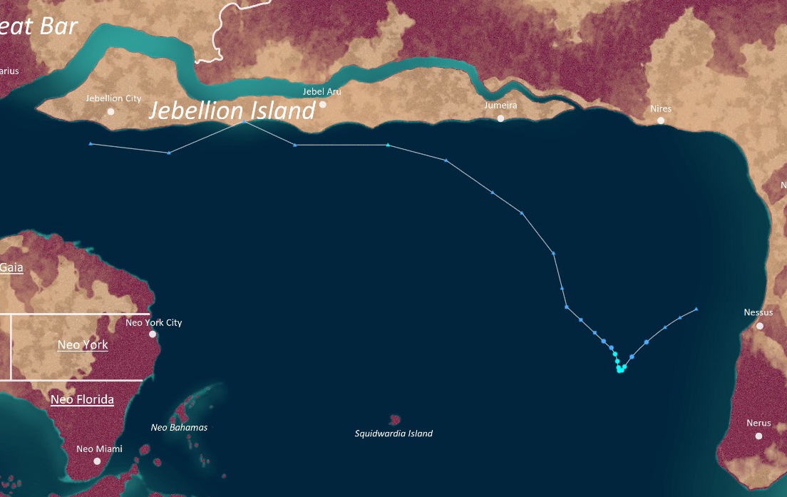
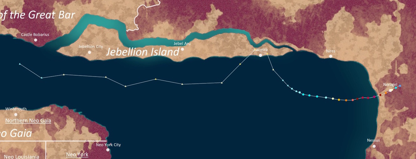
 Season summary map | |
| Seasonal boundaries | |
| First system formed | Goringffh 1 (record earliest) |
| Last system dissipated | Goringffh 2, 0025 SC |
| Strongest storm | |
| Name | Campanella |
| • Maximum winds | 870 km/h (540 mph) |
| • Lowest pressure | 543 hPa (mbar) |
| Seasonal statistics | |
| Total irregularities | 56 (record high) |
| Total swirls | 56 (record high) |
| Total uingffhicanes | 40 (record high) |
| Total malakas uingffhicanes | 32 (record high) |
| Total tempests | 19 (record high) |
| Total hyper tempests+ | 5 (record high) |
| Total fatalities | >3,077,963 |
| Total damage | $8.5212094 trillion (0024 USD) |
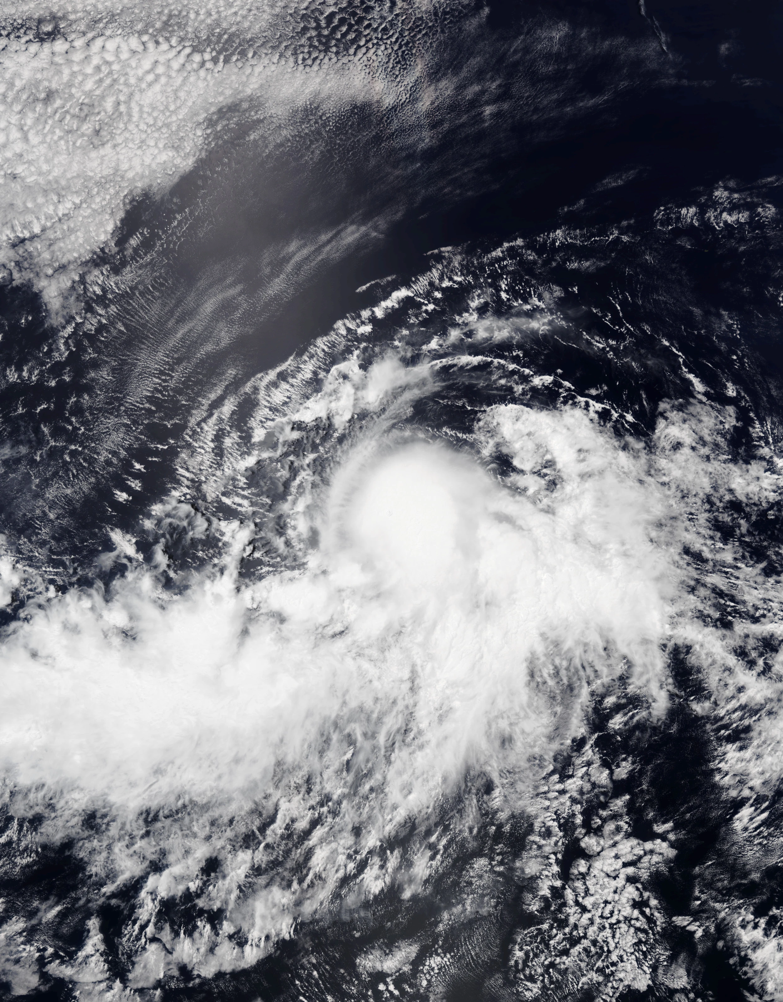
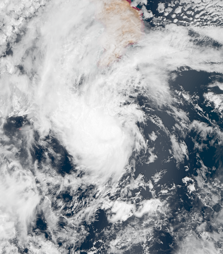
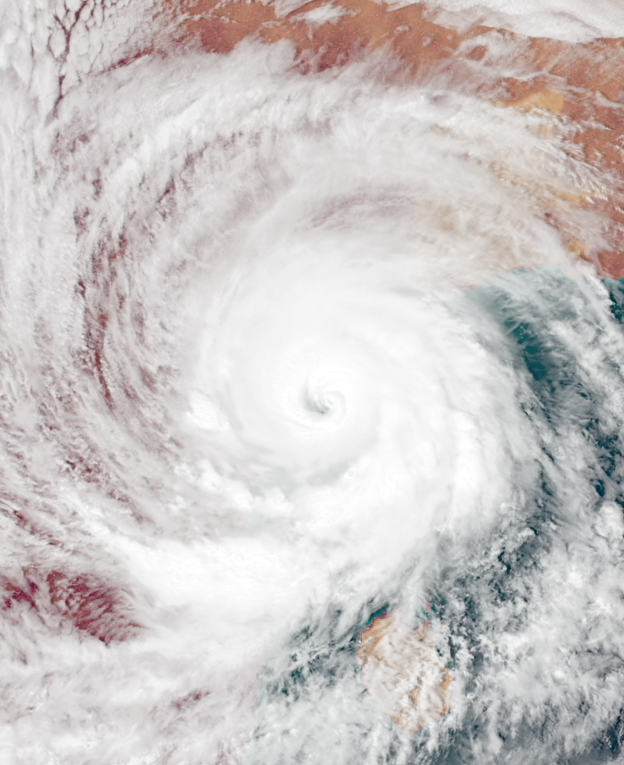
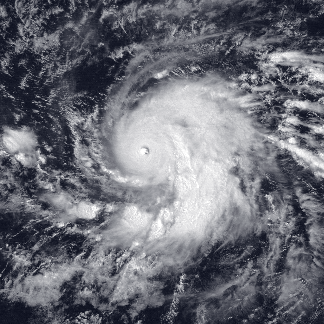
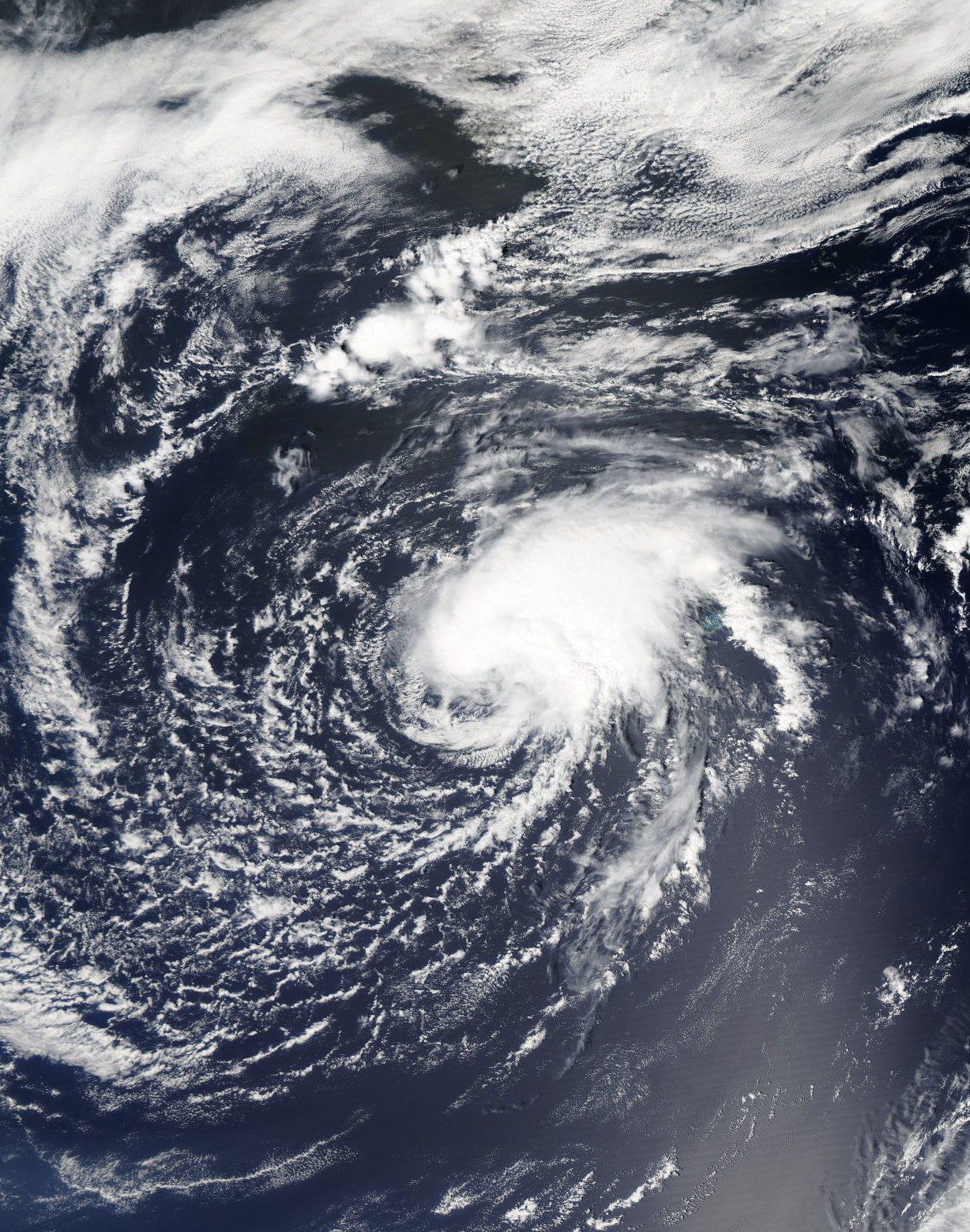
The 0024 SC Apolingffhian Uingffhicane Season was the most active Apolingffhian uingffhicane season in not only the SC era, but in recorded history as a whole. The season contained 56 named systems, 40 uingffhicanes, 32 malakas uingffhicanes, 19 tempests, 5 hyper tempests, 2 mega tempests, and 1 infinite tempest. The season's first storm, Hymnia, formed right at the start of the year at Goringffh 1.
The season was extremely notable for multiple obvious reasons. Besides being the most active Apolingffhian season as mentioned above, it contained the strongest and most intense tropical cyclone ever recorded in the Apolingffhian basin - Infnite Tempest Campanella. Another thing that was notable about the season was that it was the costliest and deadliest Apolingffhian season on record. Furthermore, the season was notable for having the most storms form in a single month - 9 storms in Septavia including one hyper tempest (Roblox). Yet another notable aspect of the year was that it was the first where Neo Gaian cities were equipped with the same wind shields and flood barriers as tabulon cities, keeping them safe from weaker storms, though this did not prevent the season from becoming damaging and deadly due to the occurrence of many tempests which overpowered the defenses.
However, the most significant aspect of the season was the fact that it took place during a very severe pandemic of the highly infective and dangerous Glorazia-24 virus which had begun during Clovingffh this year. Many uingffhian officials, including both humans and tabulons, predicted that the storm season would worsen the Glorazia-24 pandemic due to the need to travel/evacuate away from an oncoming storm and the need to socially distance/isolate from others to prevent contracting Glorazia directly contradicting one another. Unfortunately, this turned out to be true, and the Glorazia-24 pandemic is often cited as one of the reasons why the 0024 season became so catastrophic. This effect was seen in the neighboring Tornelingffhian Uingffhicane Basin as well - in fact, it was even worse due to an asteroid impact and a submarine flood basalt in the area heating up the waters to exceptionally high temperatures which led to extreme activity that included dozens of infinite tempests.
The Basin[]
Main article: Apolingffhian Uingffhicane Basin

Satellite image of the basin
The Apolingffhian Sea is an ocean located on the planet of Uingffh, situated in its northern hemisphere between the mainland and the island continent of Neo Gaia. The basin is known for being very conductive for tropical cyclone development, with an average of over 20 storms per Uingffhian year, with activity occurring year-round.
In general, tropical cyclones in this basin are called Uingffhicanes. However, they are given different classifications depending on strength. A tropical irregularity is any uingffhicane with winds less than 40 miles per hour, corresponding to the tropical depression category on Earth. Systems with winds of 40-59 miles per hour are called tropical swirls and correspond to tropical storms. Systems with winds of 60-79 miles per hour are severe tropical swirls. A storm is truly a uingffhicane once it reaches winds of 80 miles per hour or higher. In addition, uingffhicanes with winds of over 110 miles per hour are called malakas uingffhicanes and storms with winds of over 194 miles per hour tempests. Furthermore, storms with winds over 300 miles per hour are called hyper tempests, known simply as "hypercanes" on Earth. They are rather rare, being only as common as Category 5 storms on Earth.
.png)
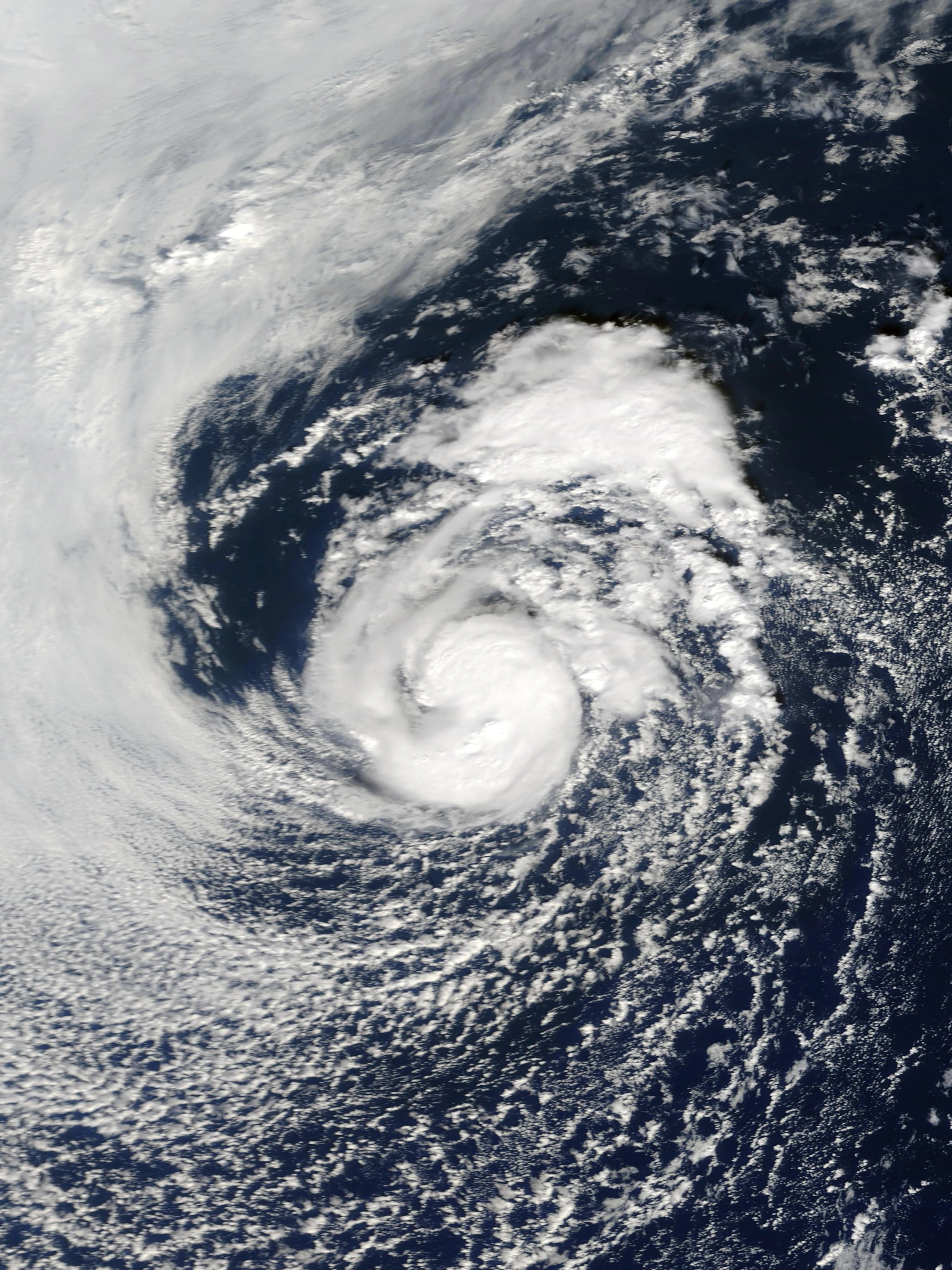
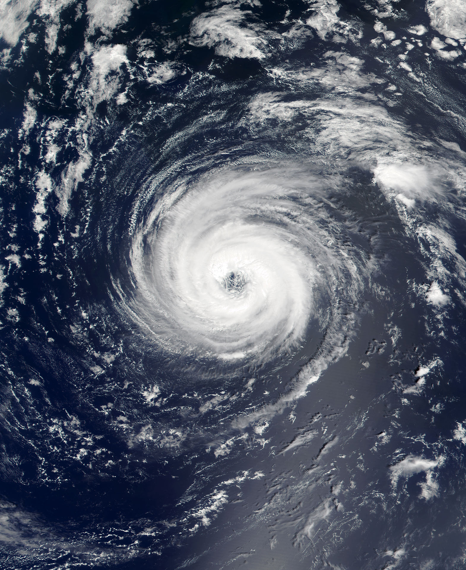
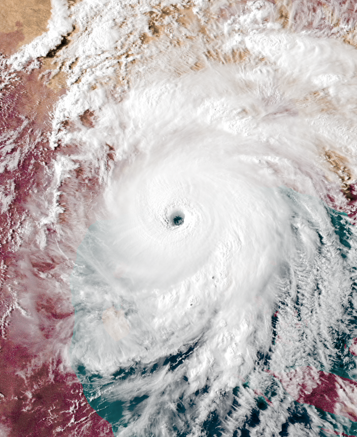
Mega Tempest Wulfgar, the first recorded storm to surpass hyper tempest strength during the SC era
Two other designations, mega tempests and infinite tempests, also exist, but they are extremely uncommon - only one storm of mega tempest strength occurs per decade, while infinite tempests only happen once every century, and are apocalyptic when they happen.
In this basin, uingffhicanes are monitored by the Apolingffh Disaster Service's Uingffhicane Branch, or ADSUB. Storms in this basin are classified using the Eudae Uingffhicane Wind Scale (EUWS), invented by Urlum Eudae Kaywell, a well-known Uingffhian scientist. The Eudae Scale is very similar to the Saffir-Simspon Scale on Earth, but with several new categories. It universal and is used for uingffhicanes in other basins as well.
Like on Earth, Apolingffhican uingffhicanes receive names once they reach tropical swirl status. Six lists of names are used in this basin and rotate regardless of year, similar to the Western Pacific Basin.
The average Apolingffhian uingffhicane season contains roughly 22 named storms, 16 uingffhicanes, 10 malakas uingffhicanes, and 3 tempests. The average amount of hyper tempests per year is slightly less than 1, while anything stronger than that only occurs once every 10 years on average. The season runs year-round, but most storms form in the Uingffhian month of Aurelius, which roughly corresponds to August on Earth.
History & Background Information[]
An example of a tabulon. (Note: colors vary)
The land areas of Apolingffh are populated by both humans and Uingffh's native intelligent species, the Tabulons, which resemble cats on Earth but sphere-shaped and with tentacle-like apendages.
Humans first formally settled on the planet in the year of 2050. The Tabulon Civilization, which was much more technologically advanced, was peaceful with humans and allowed them to settle on the island continent of Flornelia, which looked somewhat similar to North America. The continent was formally renamed "Neo Gaia" and various settlements named after Earth cities were built.
The day humans arrived on Uingffh began a new era in Uingffhian timekeeping. All years thereafter were given the suffix "SC", which stands for "since contact". The day humans arrived is known as 0000 SC.
The Apolingffh Disaster Service's Uingffhicane Branch was formed by both tabulons and humans on Neo Gaia on 0020 SC, which was also when uingffhicanes began to be recorded in an official database and began receiving names.
On Uingffh, years contain 10 months in contrast to Earth's 12, which are listed below. Each month contains 30 Earth days, making for a 300-day year.
- Goringffh
Goringffh is generally an inactive month due to cold SSTs and high wind shear as well as due to how tropical waves are rare. However, subtropical or tropical swirls that form from extratropical cyclones do occur relatively often.
- Florissa
Activity in Florissa is basically the same as Goringffh, with extratropical cyclones being the main source of activity.
- Clovingffh
Clovingffh is usually when the first storms from tropical waves form, and activity begins to increase from here. By Clovingffh, the first uingffhicane has probably formed.
- Jovette
Jovette marks the first active month of the season and when storms begin to form en masse. Jovette is often when the first malakas uingffhicanes begin to form as SSTs begin to increase. However, tempests do not normally occur during this month.
- Urvette
Urvette contains similar activity to Jovette, but is when tempests may begin to form.
- Aurelius
Aurelius marks the beginning of the peak of uingffhicane seasons. It and Septavia receive the most storms of the ten months, but not always the strongest storms since most storms tend to stay out to sea.
- Septavia
Septavia, like Aurelius, is a very active month. Landfalls and damaging storms tend to be more common in Septavia due to the warm SSTs encompassing the entire basin, which allows for storms to become strong almost anywhere near the tropical regions.
- Octavia
Activity begins to die down by Octavia, with SSTs moving west towards Neo Gaia. However, the strongest storms in a season usually form in this month due to tropical swirls frequently forming in the Gulf of Neo Mexico at this time of the year, which is a location infamous for its very high SSTs favorable for rapid intensification. Almost all hyper tempests and higher storms like Olu'um and Wulfgar formed in Octavia.
- Thanktavia
Thanktavia is even less active than Octavia, with storms only forming from tropical waves if conditions are just right. Extratropical cyclones become the prominent source for storms once again. However, Thanktavia still has the potential for a strong storm or tempest to form once in a while, but it is generally the end of the active period or even the season as a whole if the year was below-average.
- Christavia
Christavia, the final month, is the beginning of the inactive period from Christavia to Florissa, with extratropical cyclones being the main source of storms. Still, a strong cyclone can occur once in a while during this month like what happened with Zorum in 0020.

Uingffh from space. Sovin, the blue gas giant that is Uingffh's parent planet, can be seen to the left.
Though Uingffhian days are actually as long as a month since Uingffh is actually a moon of the gas giant Sovin, time is still divided into 24 hour periods to make things more manageable for humans. Time is measured using Uingffhian Time Coordinated (UTC), which is very similar to the Universal Time Coordinated used on Earth.
Geography[]
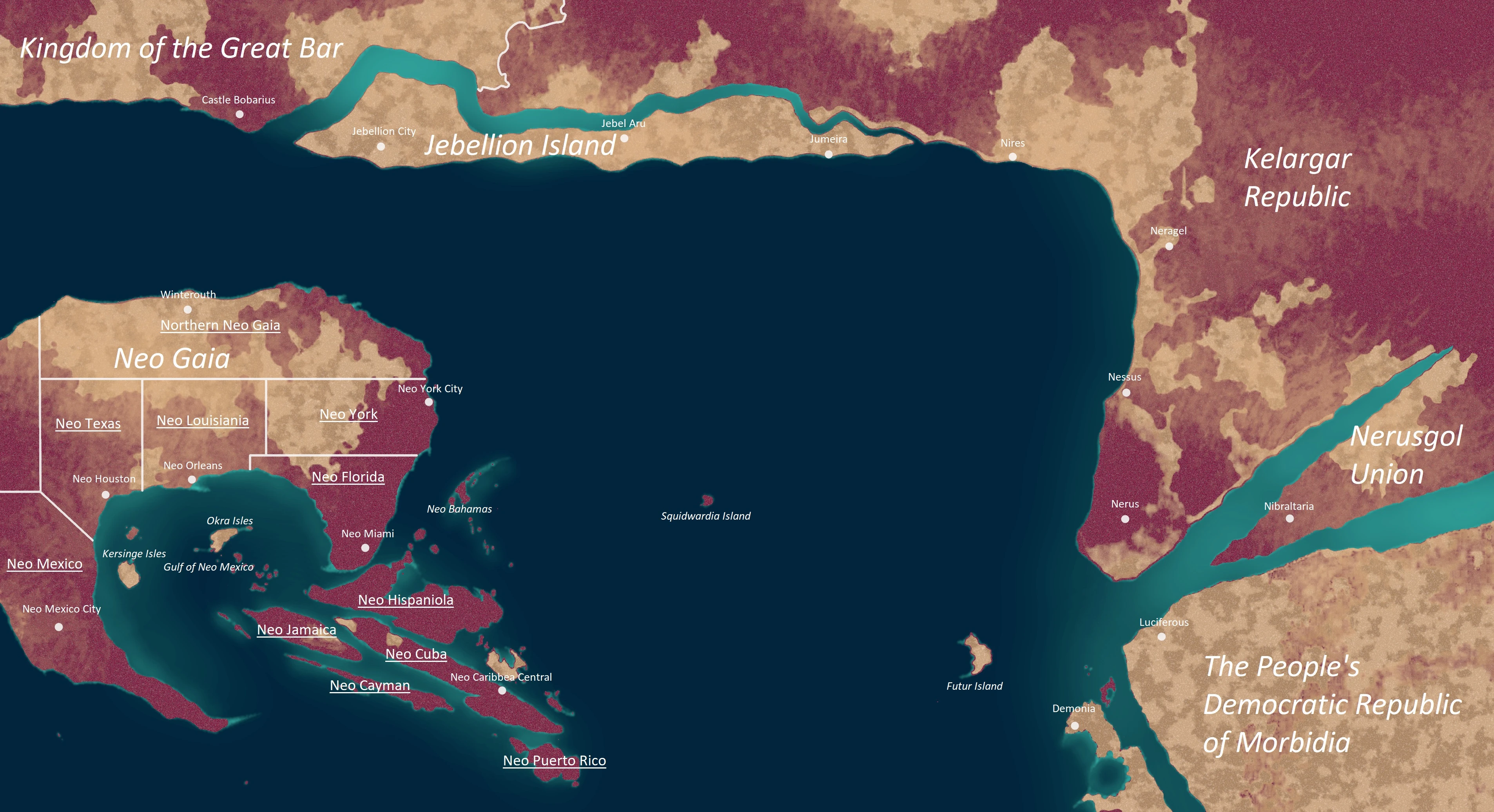

.jpeg)
A map of the Apollingffhian Ocean, with countries and major cities labeled (Note: Due to the large image size, it is recommended that you view to original file in order to read the labels)
On Uingffh, plants are colored magenta instead of green like on Earth. This is because Uingffh's sun is dimmer and redder, so Uingffhian chlorophyll and chloroplasts have to be a different color in order to absorb more light.
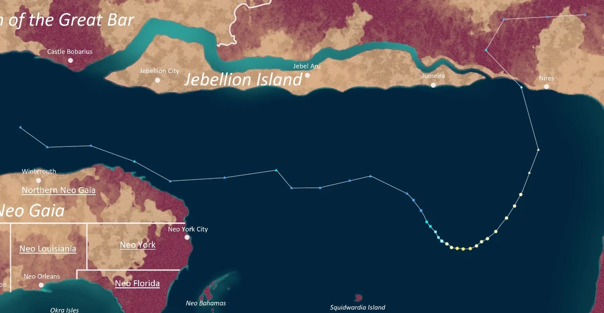
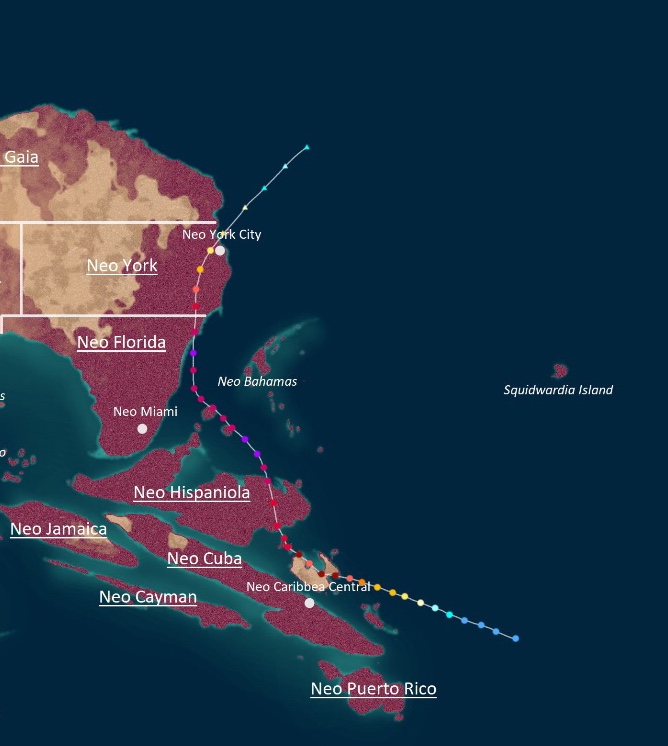
The eastern part of the sea is bordered by Neo Gaia, which is where the human population lives. Its shape is very similar to that of the North American continent on Earth; there is even a collection of islands south of Neo Florida that is similar to the Caribbean Archipelago. Due to this, many of the provinces and major cities on the continent are named after locations on Earth - for example, the Caribbean-like archipelago mentioned earlier was named Neo Caribbea. Neo Gaia and its surrounding islands receive the most uingffhicanes, unfortunately, and are at a very high risk of being hit due to warm waters and steering currents which push storms in the direction of the continent. In addition, Neo Gaia is a relatively dry and flat continent, meaning that brown ocean effects are extremely common.
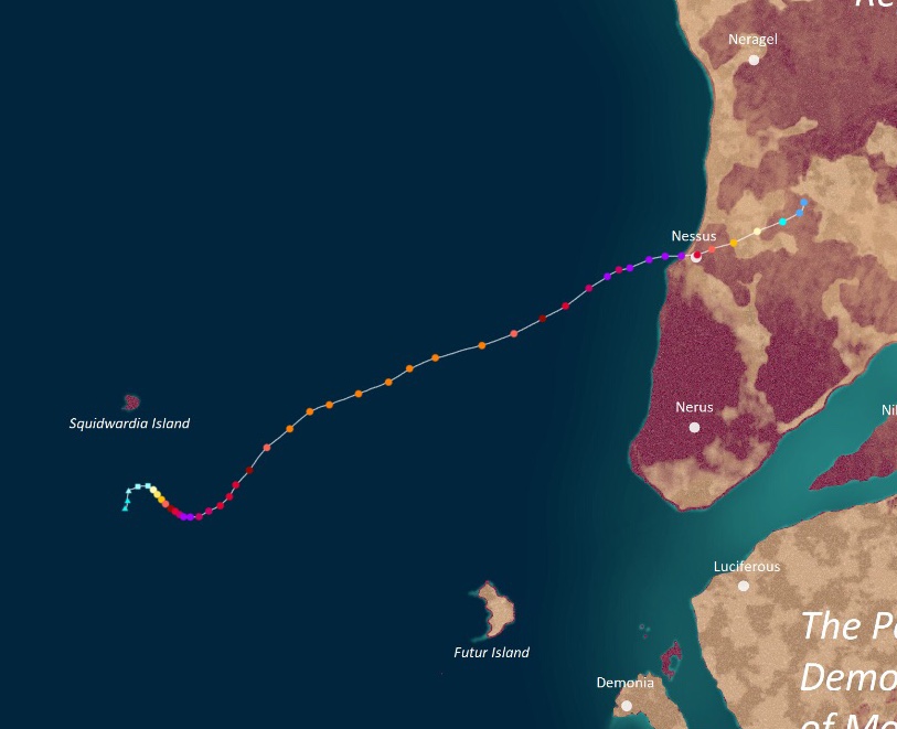
To the west is Uingffh's main landmass, a supercontinent called Ulstonia. It is where most of the tabulons reside. Three countries near Apolingffh exist in Western Ulstonia: Kelargar, Nerusgol, and Morbidia. In general, these countries are safer from uingffhicanes than Neo Gaia since tabulon buildings are stronger due to being tetrahedron-shaped and since cities are equipped with technology like wind shields and retractable flood barriers. However, storms can still caused destruction especially if they are at tempest strength.
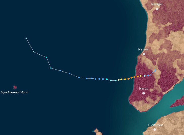
The Kelargar Republic exists on the northern part of Western Ulstonia. It is a highly conservative country embedded in tradition. Important cities in Kelargar include Neragel, Nessus, Nerus, and Nires. Kelargar is not as much of a target for uingffhicanes as Neo Gaia is since waters near the country are cold and steering currents push most storms away from the republic, but it is nowhere near completely immune to the effects of uingffhicanes, with strong storms making landfall especially near Nerus City a few times each year. Furthermore, since many of the country's residents are conservative, the threat of storms that hit the country is often downplayed, leading to more damages and deaths.
The Nerusgol Union exists in between two large straits. It is a moderately progressive country. Since it is mostly inland and does not contain major cities near the coast besides Nibraltaria, it is at low risk for uingffhicanes. However, once in a while, a very potent storm may survive passage through land and effect Nerusgol and may even reach the Sea of Nerusgol further inland.
The People's Democratic Republic of Morbidia exists south of Nerusgol. It is a communist nation with two major cities located near Apolingffh: Luciferous and Demonia. Morbidia does not receive a lot of landfalls per se, but it is notable for being the main location where tropical waves begin similar to how most waves in the Atlantic Ocean begin in Africa or Cape Verde. However, Morbidia still receives storms on special occasions, though very rarely and usually only from weak storms due to how there is a lot of dry air in the country.
To the north are Jebellion Island, a large continental island, and the United Kingdom of the Great Bar, both located on a northern strip of land completely encircling Uingffh called the Great Bar. Since waters near these nations are cold and wind shear is high, uingffhicanes practically don't hit there at all. However, their extratropical remnants affect these countries often.
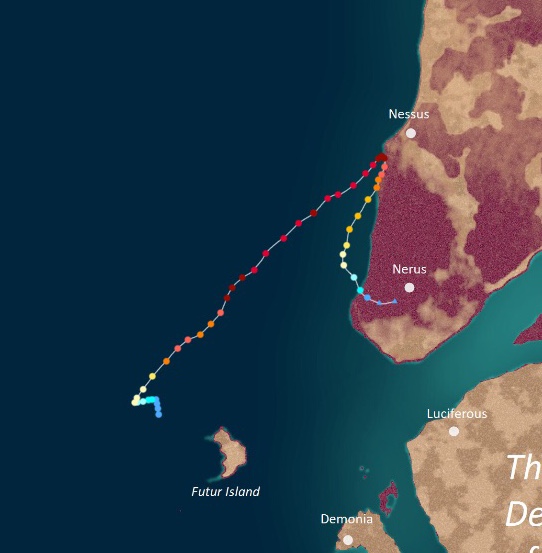
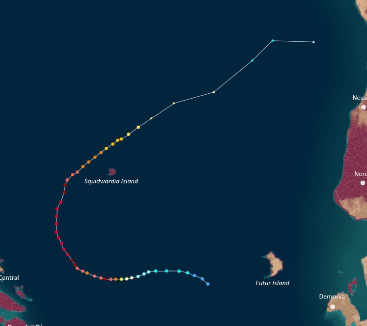
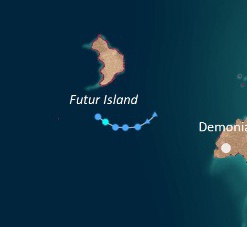
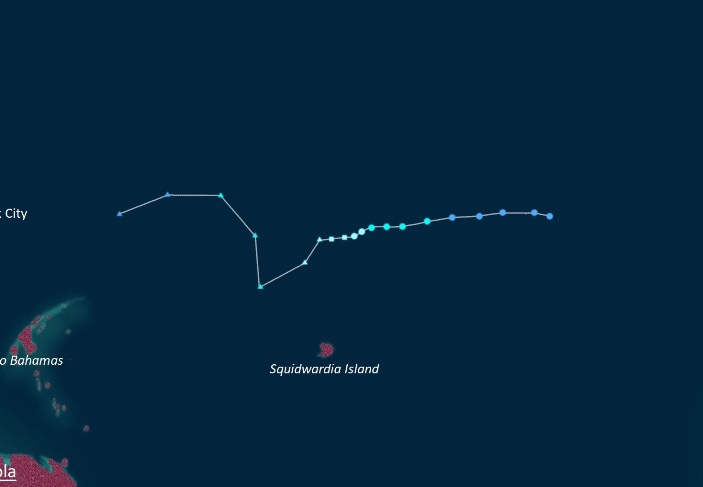
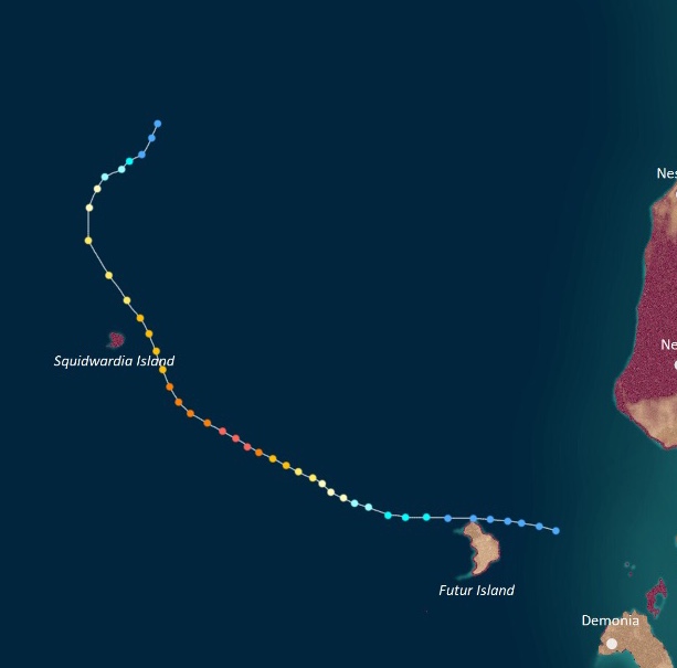
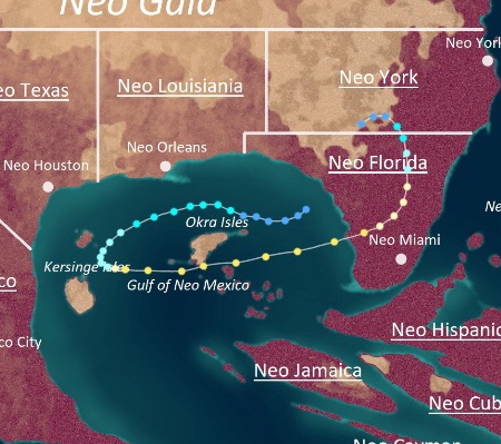
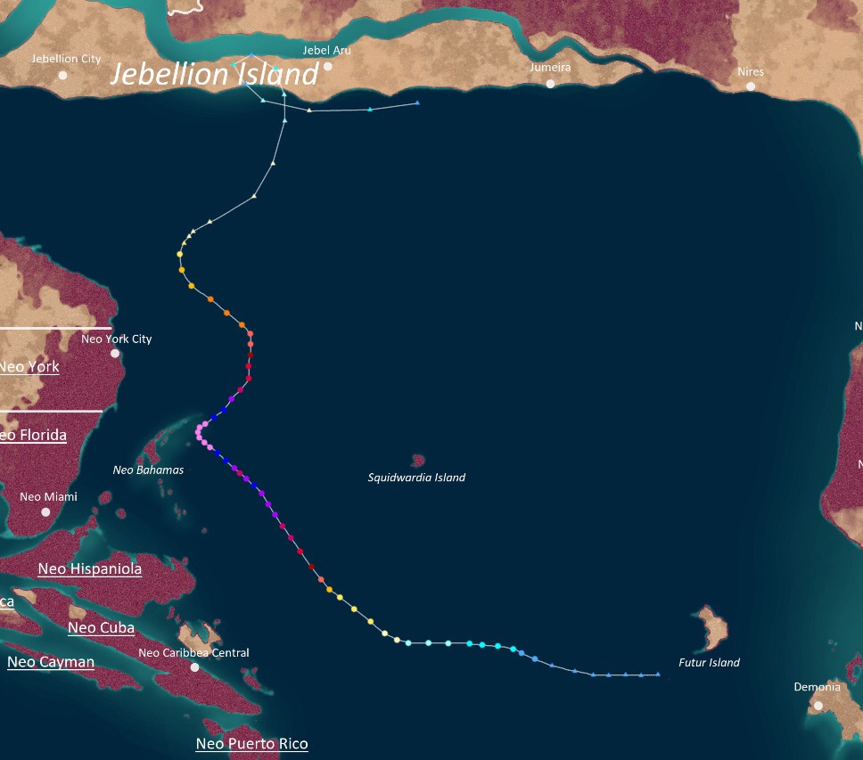
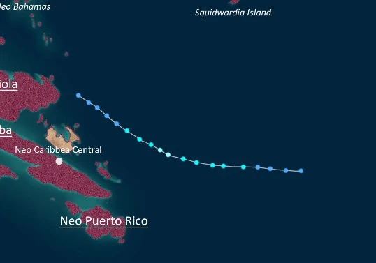
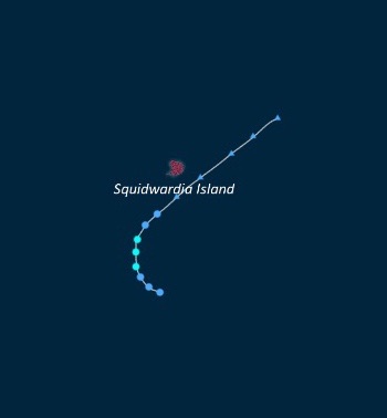
In addition to these countries, there are also several independent islands that are not affiliated with any major nation. These are Squidwardia Island, Futur Island, Neo Bahamas, the Okra Isles, and the Kersinge Isles. Uingffhicanes rarely hit Futur Island, as it is another source for tropical waves similar to Morbidia. Squidwardia Island receives close passes from storms on a regular basis, but true landfalls are rare due to the island's small size. The other islands are all located near Neo Gaia and receive lots of uingffhicanes as a result. However, the Okra and Kersinge Isles are both uninhabited, so no damage or death ever occurs there. As such, they are excluded from seasonal effects tables.
Scale[]
The creator of the EUWS, Urlum Eudae Kaywell.
Main article: Eudae uingffhicane wind scale
All tropical cyclones that form in the Apolingffhian Ocean are classified using the Eudae Uingffhicane Wind Scale (EUWS). It is very similar to the Saffir-Simpson Hurricane Wind Scale used on Earth, but with extra categories beyond Category 5. The extra categories are there because tabulon buildings are stronger and can withstand low-end Category 5 winds, necessitating higher categories to measure damage done to said structures.
| Rating | Wind Speeds (mph) | Abbreviation |
| Tropical Irregularity | ≤39 | TI |
| Tropical Swirl | 40-59 | TS |
| Severe Tropical Swirl | 60-79 | STS |
| Category 1 Uingffhicane | 80-95 | C1 |
| Category 2 Uingffhicane | 96-110 | C2 |
| Category 3 Malakas Uingffhicane | 111-129 | C3 |
| Category 4 Malakas Uingffhicane | 130-156 | C4 |
| Category 5 Malakas Uingffhicane | 157-194 | C5 |
| Stage 1 Tempest | 195-220 | T1 |
| Stage 2 Tempest | 221-240 | T2 |
| Stage 3 Tempest | 241-260 | T3 |
| Stage 4 Tempest | 261-280 | T4 |
| Stage 5 Tempest | 281-299 | T5 |
| Hyper Tempest | 300-399 | HYT |
| Mega Tempest | 400-499 | MGT |
| Infinite Tempest | 500+ | INT |
Seasonal Summary[]

Systems[]
|
Tropical Swirl Hymnia[]
| Tropical Swirl (EUWS) | |
|---|---|
| Tropical Storm (SSHWS) | |
  | |
| Duration | Goringffh 1 – Goringffh 3 |
| Peak intensity | 50 mph (80 km/h) (1-min) 997 mbar (hPa) |
Formed at 10:00 UTC on Goringffh 1 from an extratropical low in the open ocean. Hymnia was a short-lived storm that peaked on Goringffh 2 as a 50 mph tropical swirl while exhibiting a small, exposed circulation. It degenerated into a remnant low due to wind shear on Goringffh 3.
Though it did not affect land, Hymnia was notable for being the earliest storm in a season on record.
Tropical Swirl Iveerios[]
| Tropical Swirl (EUWS) | |
|---|---|
| Tropical Storm (SSHWS) | |
  | |
| Duration | Goringffh 6 – Goringffh 10 |
| Peak intensity | 40 mph (65 km/h) (1-min) 1006 mbar (hPa) |
Formed at 22:00 UTC on Goringffh 6 from an extratropical low. Iveerios was another weak and short-lived storm that peaked on Goringffh 8 with winds of 40 mph. It remained very ragged on satellite imagery for its whole life and turned extratropical on Goringffh 10.
Its remnants went on to bring some rain to western Kelargar, but only minimal damage occurred.
Severe Tropical Swirl Jove[]
| Severe Tropical Swirl (EUWS) | |
|---|---|
| Tropical Storm (SSHWS) | |
  | |
| Duration | Goringffh 23 – Goringffh 26 |
| Peak intensity | 65 mph (105 km/h) (1-min) 995 mbar (hPa) |
Formed at 14:00 UTC on Goringffh 23 from an extratropical low. Jove was somewhat stronger than the two storms before it, peaking on Goringffh 25 with winds of 65 mph and a central pressure of 995 mbar. However, the storm soon strayed north into an area of more intense wind shear, causing Jove to become extratropical the next day. Its remnants affected parts of Jebellion as well as Kelargar, but only minimal damage was reported.
One person in Squidwardia Island died of rip currents generated by Jove.
Uingffhicane Kronkus[]
| Category 1 Uingffhicane (EUWS) | |
|---|---|
| Category 1 Uingffhicane (SSHWS) | |
  | |
| Duration | Florissa 3 – Florissa 6 |
| Peak intensity | 80 mph (130 km/h) (1-min) 989 mbar (hPa) |
Formed at 01:00 UTC on Florissa 3 from a frontal low off the coast of Neo York. Kronkus curved northeast and peaked on Florissa 5 as an 80 mph Category 1 uingffhicane, becoming the first uingffhicane of the season. Cooler temperatures and high wind shear caused Kronkus to weaken down into a tropical swirl and turn extratropical the next day.
Kronkus brought swells to Neo York and Northern Neo Gaia which killed 2 people.
Uingffhicane Lamperouge[]
| Category 4 Malakas Uingffhicane (EUWS) | |
|---|---|
| Category 4 Uingffhicane (SSHWS) | |
  | |
| Duration | Florissa 13 – Florissa 18 |
| Peak intensity | 145 mph (235 km/h) (1-min) 943 mbar (hPa) |
Formedat 13:00 UTC on Florissa 13 from an extratropical cyclone. Lamperouge moved east for its entire life and initially struggled to strengthen due to cold waters and high wind shear. However, as it approached Kelargar, the storm hit an area of very favorable conditions, causing Lamperouge to rapidly intensify into a malakas uingffhicane. On Florissa 16, it peaked with winds of 145 mph, making it a C4, shortly before making landfall on Kelargar. It then dissipated inland two days later.
Thanks to the tabulons' wind shields and flood barriers, damage was only minimal, though 4 tabulons died due to rip currents.
Uingffhicane Mosa[]
| Category 2 Uingffhicane (EUWS) | |
|---|---|
| Category 2 Uingffhicane (SSHWS) | |
  | |
| Duration | Florissa 17 – Florissa 21 |
| Peak intensity | 105 mph (165 km/h) (1-min) 978 mbar (hPa) |
Formed at 04:00 UTC on Florissa 17 from an extra low in the open ocean. Mosa was an unnotable storm that took a U-shaped path over the open Apolingffhian ocean. On Florissa 19, Mosa reached its peak intensity of 105 mph and 978 mbar (a Category 2 uingffhicane) while exhibiting a slightly ragged but still well-defined eye. Afterwards, as Mosa ventured north, it began to grow in side while wind shear began to degrade the storm. On Florissa 21, Mosa became extratropical and hit Nires City.
Mosa did not cause any damage or deaths while tropical, but it did cause some wind damage while extratropical which led to $4 million in damages. Thankfully, no deaths were reported.
Uingffhicane Neldomar[]
| Category 2 Uingffhicane (EUWS) | |
|---|---|
| Category 2 Uingffhicane (SSHWS) | |
  | |
| Duration | Florissa 22 – Florissa 26 |
| Peak intensity | 100 mph (160 km/h) (1-min) 970 mbar (hPa) |
Formed at 07:00 UTC on Florissa 22 from a frontal low near Neo Bahamas. Neldomar was a moderately powerful storm that peaked on Florissa 25 as a 100 mph Category 2 uingffhicane while moving north. Not long after, the storm ventured into an area of more hostile conditions, causing it to dissipate on Florissa 26.
Neldomar's precursor disturbance brought some rain to Neo Bahamas while Neldomar itself created rip currents and swells along the coast of Neo Gaia. A couple died after drowning in a rip current in Neo York City.
Uingffhicane Odelium[]
| Category 4 Uingffhicane (EUWS) | |
|---|---|
| Category 4 Uingffhicane (SSHWS) | |
  | |
| Duration | Clovingffh 5 – Clovingffh 11 |
| Peak intensity | 150 mph (240 km/h) (1-min) 936 mbar (hPa) |
Formed at 15:00 UTC on Clovingffh 5 near Futur Island, becoming the first storm of the season to form from a tropical wave. The system turned west and stalled over an area of warm water, where it rapidly intensified into a Category 4 uingffhicane. On Clovingffh 9, Odelium reached its peak intensity of 150 mph and 936 mbar before accelerating north. While doing so, colder waters and high wind shear tore away at Odelium's structure until it eventually became extratropical on Clovingffh 11.
Its extratropical remnants went on to hit Neragel, where they caused 5 deaths and $1.4 million in damages due to high winds.
Tropical Swirl Popsiclea[]
| Tropical Swirl (EUWS) | |
|---|---|
| Tropical Storm (SSHWS) | |
  | |
| Duration | Clovingffh 6 – Clovingffh 9 |
| Peak intensity | 45 mph (70 km/h) (1-min) 1003 mbar (hPa) |
Formed at 11:00 UTC on Clovingffh 6 from an extratropical cyclone. Popsiclea moved southeast, but then stalled and gradually intensified. On Clovingffh 8, just as it was about to turn northwest, it reached its peak intensity of 45 mph and 1003 mbar. The next day, high wind shear caused Popsiclea to lose all of its convection and degenerate into a remnant low while off the coast of Nessus City.
Popsiclea's precursor cyclone dumped some heavy rain onto Jebellion Island, but no damage was reported.
Uingffhicane Rizal[]
| Category 3 Malakas Uingffhicane (EUWS) | |
|---|---|
| Category 3 Uingffhicane (SSHWS) | |
  | |
| Duration | Clovingffh 10 – Clovingffh 21 |
| Peak intensity | 120 mph (195 km/h) (1-min) 959 mbar (hPa) |
Formed at 19:00 UTC on Clovingffh 10. Rizal was a rather long-lived storm that had a unique track. As it curved north, it rapidly intensified into a Category 3, but an eyewall replacement cycle caused Rizal to weaken into a C2 for a brief time. However, Rizal soon regained its strength while turning east. Developing a large eye, Rizal peaked on the 15th with winds of 120 mph and a central pressure of 959 mbar in the open ocean. Afterwards, wind shear began to degrade the storm as it made a small cyclonic loop. After turning north as a weakening TS, Rizal dissipated on Clovingffh 21.
The storm brought some rough surf to Squidwardia, but no damage or deaths were reported.
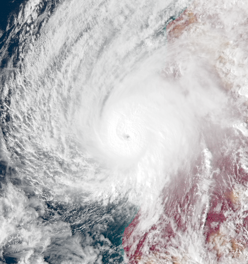
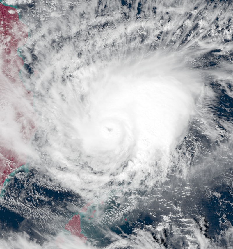
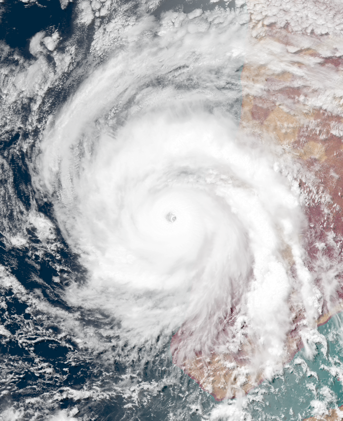
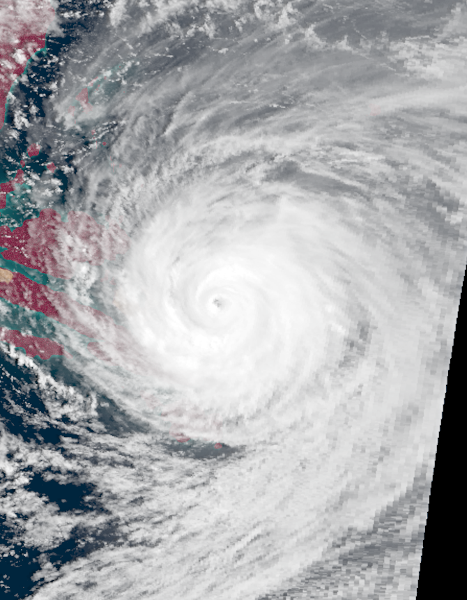
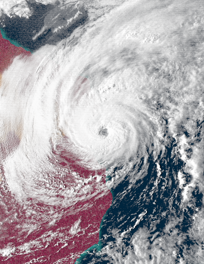
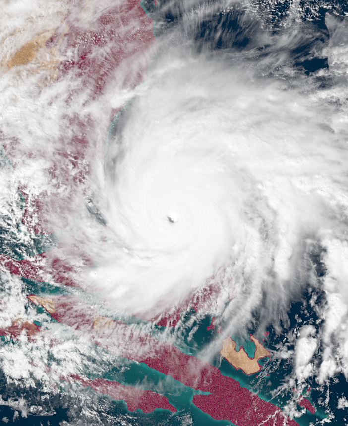
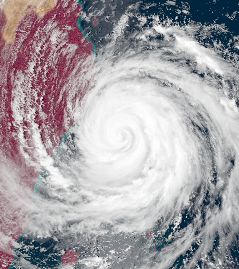
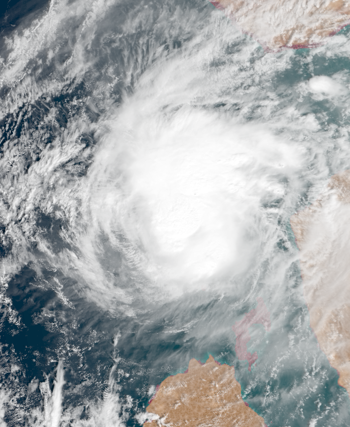
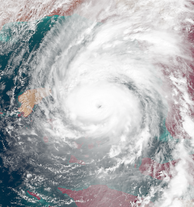
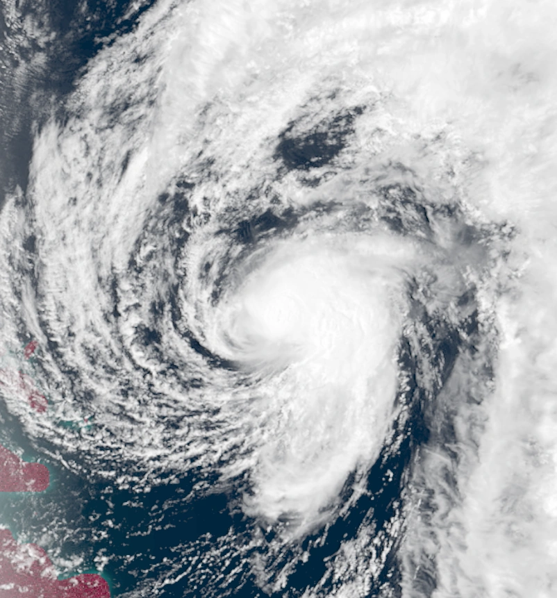
Tempest Sam[]
| Stage 2 Tempest (EUWS) | |
|---|---|
| Category 5 Uingffhicane (SSHWS) | |
  | |
| Duration | Clovingffh 15 – Clovingffh 26 |
| Peak intensity | 230 mph (370 km/h) (1-min) 853 mbar (hPa) |
Formed at 05:00 UTC on Clovingffh 14 near Futur Island. Sam initially stalled, but was then carried northeast due to a large trough to the northwest. There, rapid intensification occurred, and Sam strengthened into the first tempest of the season. On Clovingffh 20, Sam reached its first peak of 225 mph before an eyewall replacement cycle weakened the storm down to a T1 for a few hours. Afterwards, the storm re-strengthened, and on Clovingffh 22, Sam reached its peak intensity of 230 mph and 853 mbar. Shortly after, Sam made landfall southwest of Nessus City, stalled, and turned south, emerging back into open waters as a weakening C3. It then made one last landfall at tropical swirl strength before dissipating on the 26th near Nerus.
Sam caused a large amount of destruction in Kelargar which was amplified by the Glorazia-24 pandemic, which was beginning to spread rapidly at the time. The storm's winds breached the Nessus City wind shields and wrought havoc on the buildings within, reducing many to rubble. In addition, with the failure of the wind shields, heavy rain was allowed to pour into the city, resulting in extreme flooding. A total of 982,377 structures were damaged or destroyed by Sam. Besides the usual storm effects, Sam also contributed to Glorazia's spread. With many homes destroyed, millions of tabulons were displaced and had to go to storm shelters, where some asymptomatic individuals spread the virus among evacuees. Overall, Sam caused $213 billion in damages and 3,105 deaths.
Tempest Trinilia[]
| Stage 2 Tempest (EUWS) | |
|---|---|
| Category 5 Uingffhicane (SSHWS) | |
  | |
| Duration | Jovette 1 – Jovette 13 |
| Peak intensity | 225 mph (360 km/h) (1-min) 860 mbar (hPa) |
Formed at 23:00 UTC on Jovette 1. Trinilia curved northwest over open waters, where it began to rapidly intensify thanks to favorable conditions. On Jovette 5, Trinilia became the season's second tempest, but an eyewall replacement cycle caused the storm to weaken shortly after. However, the system completed the ERC and regained its strength before peaking on Jovette 8 as a 225 mph Stage 2 tempest. It then turned northeast and began to weaken due to wind shear and cooler waters. Eventually, Trinilia became an extratropical cyclone while a category 2 uingffhicane on Jovette 13.
As Trinilia stayed away from land masses, no damages were reported. However, 3 people in Neo Caribbea died from rip currents.
Tropical Swirl Vectoriom[]
| Tropical Swirl (EUWS) | |
|---|---|
| Tropical Storm (SSHWS) | |
  | |
| Duration | Jovette 4 – Jovette 5 |
| Peak intensity | 45 mph (70 km/h) (1-min) 1000 mbar (hPa) |
Formed at 14:00 UTC on Jovette 4 south of Futur Island. Vectoriom was a short-lived but erratic system that briefly peaked on Jovette 5 with winds of 45 mph and a central pressure of 1000 mbar. It then dissipated due to wind shear.
Vectoriom caused some rough surf along the coast of Southern Futur Island, but no effects were reported.
Severe Tropical Swirl Wally[]
| Severe Tropical Swirl (EUWS) | |
|---|---|
| Category 1 Uingffhicane (SSHWS) | |
  | |
| Duration | Jovette 5 – Jovette 8 |
| Peak intensity | 75 mph (120 km/h) (1-min) 988 mbar (hPa) |
Formed at 07:00 UTC on Jovette 5 from an extratropical low in the open Apolingffhian sea. Wally moved east for its whole life and experienced its peak intensity upon formation, peaking as a 75 mph C1-equivalent STS on the 5th. This was due to its strength being inherited from Wally's precursor extratropical low. After peaking, Wally underwent a steady weakening trend and dissipated on Jovette 8 without affecting any land.
Uingffhicane Xythra[]
| Category 5 Malakas Uingffhicane (EUWS) | |
|---|---|
| Category 5 Uingffhicane (SSHWS) | |
  | |
| Duration | Jovette 9 – Jovette 13 |
| Peak intensity | 160 mph (255 km/h) (1-min) 933 mbar (hPa) |
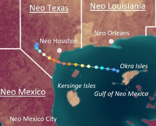
Formed at 15:00 UTC on Jovette 9 in the Gulf of Neo Mexico, the first storm of the season to do so. Moving west, Xythra rapidly intensified as it approached Neo Texas. becoming a malakas uingffhicane on Jovette 11. Later that day, Xythra reached its peak intensity of 160 mph, a Category 5 uingffhicane. After sustaining C5 winds for around 6 hours, Xythra made landfall south of Neo Houston at peak intensity. Xythra later dissipated over land on Jovette 13.
Xythra was known to be the first major storm to hit Neo Gaia since its wind shields and flood barriers were first installed, so the storm was often touted as the shields and barriers' first true test. To the elation of engineers and scientists, the technology were successful in blocking Xythra's storm surge and high winds, resulting in only minimal damage and no deaths. However, many people skeptical of the defenses decided to evacuate inland anyway, which resulted in an uptick in Glorazia-24 cases due to crowding in evacuation centers.
Uingffhicane Ysila[]
| Category 5 Malakas Uingffhicane (EUWS) | |
|---|---|
| Category 5 Uingffhicane (SSHWS) | |
  | |
| Duration | Jovette 10 – Jovette 20 |
| Peak intensity | 175 mph (280 km/h) (1-min) 911 mbar (hPa) |
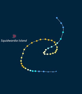
Formed at 04:00 UTC on Jovette 10 from a tropical disturbance near Futur Island. Ysila scraped the northern tip of Futur as an irregularity on Jovette 11 as it began its journey northwest. Afterwards, it rapidly intensified in open waters much like the previous storm Xythra. On Jovette 15, Ysila reached its peak intensity of 175 mph and 911 mbar before wind shear and cooler waters began to weaken the storm. On Jovette 17, Ysila passed close to Squidwardia Island as a weakening C3, triggering a Class I Blue Alert. Eventually, on Jovette 20, Ysila dissipated and its remnants were absorbed into a frontal low. Ysila brought heavy rain to Futur Island and Squidwardia Island, with numerous incidents of minor flooding and rough surf. In Futur, 3 deaths were reported - two from drowning and one from being struck by a fallen tree. No deaths occurred in Squidwardia however, as the island became deserted following the cataclysmic Hyper Tempest Zephyriom of the previous year. Overall, Ysila caused $18 million in damages and 3 deaths.
Tempest Zol[]
| Stage 3 Tempest (EUWS) | |
|---|---|
| Category 5 Uingffhicane (SSHWS) | |
  | |
| Duration | Jovette 16 – Jovette 30 |
| Peak intensity | 255 mph (410 km/h) (1-min) 826 mbar (hPa) |
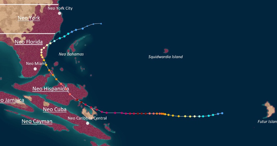
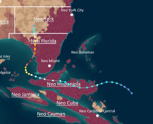
Formed at 20:00 UTC on Jovette 16 in the open Apolingffhian ocean. Zol was a powerful storm that wrought havoc across Neo Caribbea and the eastern Neo Gaian provinces. Zol rapidly intensified and reached its first peak as a 160 mph C5 on Jovette 20 while slowly moving west, but then weakened back into a C4 during an eyewall replacement cycle. However, Zol quickly recovered and became the third tempest of 0024 on Jovette 21. Eventually, Zol reached its peak intensity of 255 mph and 826 mbar, a strong Stage 3 tempest, on Jovette 23. An increase in wind shear caused it to weaken down to a T1 before hitting Neo Hispaniola on Jovette 25 while turning northwest. On Jovette 27, Zol made a final landfall on Neo Florida as a C3 before turning east and dissipating off the coast of Neo York.
Zol proved to be a devastating blow to Neo Gaian cities, as its powerful winds and extensive flooding tore through newly-built wind shields and storm surge barriers with ease. In Neo Hispaniola, a total of 5 cities had their uingffhicane defenses breached, and nearly all buildings in those cities were completely flattened. Several small villages which were not equipped with shields and barriers due to the onset of Glorazia-24 also suffered from Zol, with many being buried under mudslides or flattened by winds. This also occurred in neighboring Neo Cuban small towns, which experienced nearly as much rainfall as Neo Hispaniola. In addition to Neo Cuba and Neo Hispaniola, Neo Florida was also impacted by Zol, though damage there was minimal since Zol was unable to pierce the province's wind shields and flood barriers. Overall, Zol caused $216 billion in damages along with 4,362 fatalities, with the large death count being blamed on a lack of adequate evacuations thanks to paranoia surrounding Glorazia-24.
Uingffhicane Akerius[]
| Category 4 Uingffhicane (EUWS) | |
|---|---|
| Category 4 Uingffhicane (SSHWS) | |
  | |
| Duration | Urvette 1 – Urvette 4 |
| Peak intensity | 130 mph (210 km/h) (1-min) 950 mbar (hPa) |
Formed at 12:00 UTC on Urvette 1 from a low pressure area along a cold front over Neo Bahamas. Akerius accelerated northwest for much of its life, where it rapidly intensified due to warm waters. On Urvette 3, Akerius reached its peak intensity of 130 mph and 950 mbar, a Category 4 uingffhicane. However, its peak was short-lived, as the storm quickly weakened and became extratropical on Urvette 4 due to high wind shear.
Its remnants went on to bring some rain and gusty winds to Neragel. Besides minimal damage in Neo Bahamas from Akerius' precursor disturbance, the storm caused no harm to land.
Uingffhicane Boris[]
| Category 4 Uingffhicane (EUWS) | |
|---|---|
| Category 4 Uingffhicane (SSHWS) | |
  | |
| Duration | Urvette 3 – Urvette 7 |
| Peak intensity | 140 mph (225 km/h) (1-min) 943 mbar (hPa) |
A frontal low formed on Urvette 1 over the Gulf of Neo Mexico, which eventually formed into an irregularity at 05:00 UTC on Urvette 3 off the coast of Neo York. After being named Boris on Urvette 4, the storm began to slowly move towards the Northern Neo Gaia-Neo York border. On Urvette 5, Boris reached its peak intensity of 140 mph (C4) before making a rare landfall on Northern Neo Gaia the following day. After recurving back out to sea, Boris became post-tropical on Urvette 6.
Though the areas Boris affected were sparsely populated, rather severe damage was recorded due to its unusual landfall location. As no wind shields or flood barriers had been set up in Northern Neo Gaia due to the supposed unlikelyhood of a uingffhicane landfall, many buildings and towns were left vulnerable. Most in Boris' path were flattened by the winds or put underwater due to flooding. In addition, large waves of over 30 feet were recorded as far south as Neo York City. Overall, Boris caused $4.2 billion in damages and 13 fatalities.
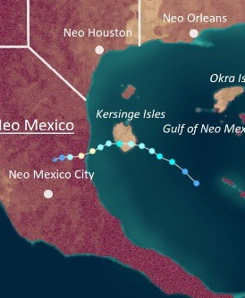
Uingffhicane Cecile[]
| Category 1 Uingffhicane (EUWS) | |
|---|---|
| Category 1 Uingffhicane (SSHWS) | |
  | |
| Duration | Urvette 4 – Urvette 7 |
| Peak intensity | 90 mph (145 km/h) (1-min) 983 mbar (hPa) |
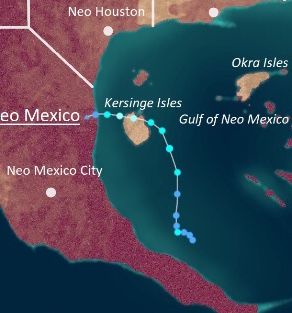
A tropical wave developed in the Gulf of Neo Mexico which eventually become an irregularity at 04:00 UTC on Urvette 4. This irregularity at around noon the same day and became a 70 mph severe tropical swirl before hitting the Kersinge Isles at that intensity on Urvette 5. After briefly weakening down into a tropical swirl due to land interaction, Cecile re-intensified and rapidly peaked as a uingffhicane with winds of 90 mph on Urvette 6. Shortly after, Cecile made landfall northeast of Neo Mexico City before dissipating over land on Urvette 7.
Cecile brought strong winds and large waves to the Kersinge Isles as an STS, but no damage was reported since the islands are unpopulated. Meanwhile, in Neo Mexico, numerous mudslides occurred due to heavy rain alongside gusty winds, flooding, and a storm surge of 5 feet. A Class IV Yellow Emergency was put into effect for the area. However, since the areas in Neo Mexico affected by Cecile were sparsely populated and protected by wind shields, only minimal damage was reported. No deaths were reported in association with the uingffhicane.
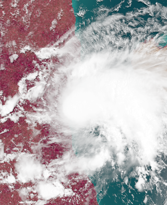
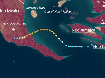
Subtropical Swirl Destriom[]
| Subtropical Swirl (EUWS) | |
|---|---|
| Subtropical Storm (SSHWS) | |
  | |
| Duration | Urvette 10 – Urvette 12 |
| Peak intensity | 45 mph (70 km/h) (1-min) 1000 mbar (hPa) |
An extratropical cyclone formed off the coast of Neo York. The ADSUB monitored the system until its eventual formation into a subtropical irregularity at 23:00 UTC on Urvette 12. Moving east, the system strengthened into Subtropical Swirl Destriom on the 11th, peaking later that day with winds of 45 mph and a central pressure of 1000 mbar while exhibiting an exposed core. Soon after, wind shear tore apart Destriom and the swirl dissipated on Urvette 12.
Destriom did not affect land.
Tempest Emblem[]
| Stage 5 Tempest (EUWS) | |
|---|---|
| Category 5 Uingffhicane (SSHWS) | |
  | |
| Duration | Urvette 13 – Urvette 25 |
| Peak intensity | 290 mph (465 km/h) (1-min) 814 mbar (hPa) |
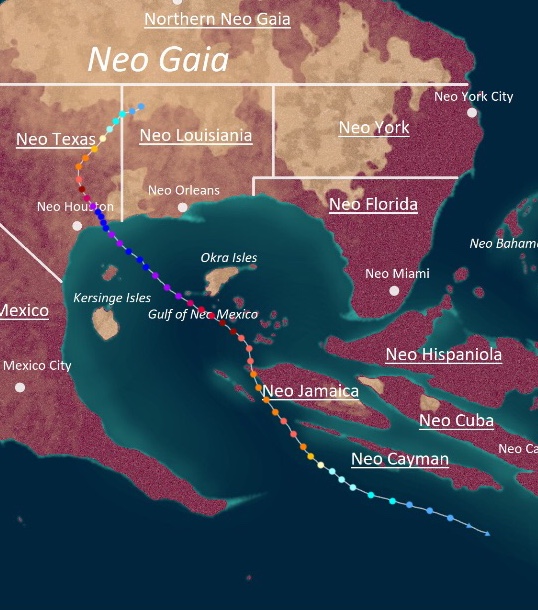
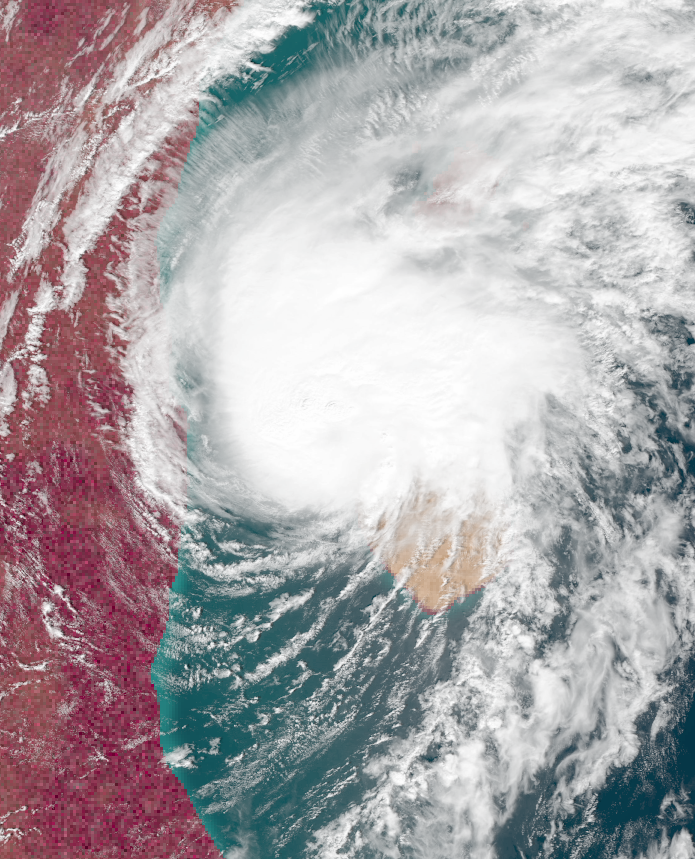
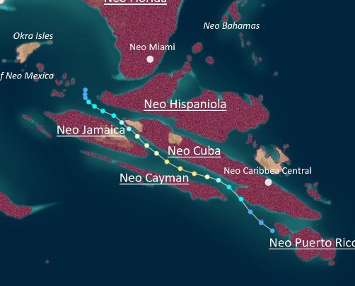
Late on Urvette 12, a tropical disturbance was detected south of Neo Cayman. At 08:00 UTC the following day, enough convection developed for the ADSUB to upgrade the system into a tropical irregularity. On Urvette 14, the system gained gale-force winds and received the name Emblem. Afterwards, Emblem began a period of rapid intensification and reached an initial peak intensity of 170 mph (a Category 5 on the EUWS) on Urvette 16. Then, Emblem underwent an eyewall replacement cycle and hit Neo Jamaica as a C4 on Urvette 17. However, upon entering the Gulf of Neo Mexico, Emblem re-strengthened and began another period of rapid deepening. On Urvette 18, Emblem became a tempest, and on Urvette 20, the storm reached its peak intensity of 290 mph and 814 mbar, an exceptionally powerful Stage 5 tempest. At peak strength, Emblem measured over 800 miles (1287 kilometers) in diameter. On Urvette 21, after briefly weakening down into a T4 as a result of another ERC, Emblem made landfall a few hundred miles east of Neo Houston. The storm then spent four days weakening over land before eventually dissipating over Neo Louisiana on the 25th.
Emblem was a catastrophic system due to a combination of poor preparation and its immense strength breaking through anti-storm defenses with ease. For one, Emblem was powerful enough to destroy Neo Houston's wind shields with its 250+ mph wind gusts, resulting in severe wind damage. With cities exposed, buildings became vulnerable to not only direct wind damage, but large flying projectiles including lawn furniture, vehicles, broken wind shield shards, mobile homes, trailers, and even whole office buildings (yes, Emblem was that powerful), which practically decimated every building into rubble including the sturdiest skyscrapers. Even more devastating, however, was the storm's 40+ foot storm surge and 39+ inches of rain which brought flash flooding all the way to Neo Louisiana and Northern Neo Gaia. The towns not damaged by winds suffered from large waves and inundation which claimed around 845,600 structures. Numerous crops were destroyed, harming Neo Texas' economy. However, the threat of Glorazia-24 was the factor that greatly worsened the damage and death toll of Emblem. Many humans were afraid of evacuating due to being afraid of getting infected by the highly unpredictable and deadly virus, so numerous people stayed in their homes, where they ended up being trapped by the storm and forced to endure Emblem's wrath by themselves. Furthermore, many rescue operations were unable to be carried out due to most work being halted by Glorazia, leading to several deaths that could have been prevented had the pandemic not occurred. Overall, Emblem caused a shocking $682.9 billion in damages and 10,325 fatalities.
Thankfully, the tabulons were able to rebuild the wind shields by the end of the month, but not without the consequence of inadvertently exposing Neo Houston citizens to Glorazia-24 through asymptomatic workers.
Tempest Fragilia[]
| Stage 4 Tempest (EUWS) | |
|---|---|
| Category 5 Uingffhicane (SSHWS) | |
  | |
| Duration | Urvette 15 – Urvette 25 |
| Peak intensity | 270 mph (435 km/h) (1-min) 813 mbar (hPa) |
On Urvette 14, a tropical wave was spotted in the open Apolingffhian ocean which was eventually classified as a tropical irregularity at 16:00 UTC the next day. Steadily intensifying due to favorable conditions, the irregularity became Tropical Swirl Fragilia on Urvette 16 and began rapid intensification. On Urvette 19, Fragilia gained a pinhole eye and became a tempest, but an eyewall replacement happened shortly after. However, Fragilia not only regained its strength, but intensified even more, making landfall on Neo Hispaniola as a Stage 2 tempest on Urvette 21. Despite landfall, Fragilia only continued strengthening. Not long after emerging into the waters east of Neo Florida, Fragilia reached its peak intensity of 270 mph and 813 mbar, a stage 4 tempest, on Urvette 22. Then, another eyewall replacement cycle occurred as Fragilia triggered Red Alerts and Red Emergencies all throughout Neo Florida, Neo Bahamas, and Neo York. The storm briefly re-attained T4 status before hitting a few hundred miles south of the Neo Florida-Neo York border on Urvette 24. Fragilia rapidly weakened due to land interaction shortly after, becoming extratropical over Neo York City on the 25th.
Fragilia brought an onslaught of destruction in Neo Cuba, Neo Hispaniola, Neo Florida, Neo Bahamas, and Neo York comparable to that of Tempest Emblem, another powerful and damaging system that existed at the same time as Fragilia. Wind shields and flood barriers were destroyed in Neo Hispaniola, Neo Florida, and parts of Neo York, leading to exceptionally high property damage. Power was lost for a total of 17 million residents due to flooding destroying power sources. Like with Emblem, refusal to evacuate in fear of Glorazia-24 led to a large amount of fatalities, as many who chose stay were crushed by debris or drowned in flooding. Overall, Fragilia caused $440 billion in damages and 7,982 fatalities.
Tempest Gaelia[]
| Stage 4 Tempest (EUWS) | |
|---|---|
| Category 5 Uingffhicane (SSHWS) | |
  | |
| Duration | Urvette 15 – Urvette 26 |
| Peak intensity | 265 mph (425 km/h) (1-min) 829 mbar (hPa) |
An area of low pressure with gale-force south of Squidwardia Island was detected on Urvette 15. However, a closed circulation did not develop until 22:00 UTC that day, when Subtropical Swirl Gaelia was officially desgniated. Over the next few days, Gaelia stalled over warm waters, causing it to rapidly intensify. On Urvette 18, Gaelia reached its first peak intensity of 265 mph and 830 mbar, a stage 4 tempest. Afterwards, cooler waters caused Gaelia to weaken as it began to accelerate northeast. By Urvette 20, Gaelia had been downgraded into a mere Category 4 uingffhicane. However, weakening ceased by then, and the storm maintained C4 status until the 22nd, when warm waters off the coast of Kelargar led to a second period of rapid intensification. On Urvette 23, Gaelia reached its second peak intensity of 265 mph and 829 mbar. The following day, Gaelia hit Nessus City at peak intensity, where it rapdily weakened due to land until its dissipation on Urvette 26.
Like with Emblem and Fragilia, Gaelia caused severe damage to Nessus due to breaching its anti-uingffhicane technology. Numerous Class VIII Red Emergencies were declared across the area. Luckily, those in the storm's path heeded evacuation orders, so deaths were kept low. However, this came at the cost of increasing the spread Glorazia-24 - Kelargar's government did not take the virus seriously. Multiple evacuation shelters became hotspots for the Glorazia virus. As for the actual property damage, it was typical of that of a tempest - almost all buildings were destroyed due to extreme 200+ mph winds and large flying debris. Entire skyscrapers were toppled while the small businesses and homes were blown away without a trace. In total, Gaelia caused $410 billion in damages and 1,009 deaths.
The name of the tempest caused some online controversy due to sharing its name with an imfamous tabulon minister named Gaelia Gerolaze from a faraway country called Kaywell. Many jokes and memes were created on the internet associating the storm with Minister Gerolaze - even Prime Minister Sentar Kraglathea firself joined in on the trend. However, these actions were harshly denounced as insensitive by more progressive politicians like Urania Sido and Malcalia Breisgau, causing Minister Kraglathea's approval ratings, which had already been low following a controversial remark regarding Mega Tempest Colin of the previous year, to plummet even further. In fact, just a few days later during the Aurelius 1 Kelargan election where Kraglathea and Sido competed for position of next prime minister, Sido won by a huge landslide and received a record 81% of the votes.
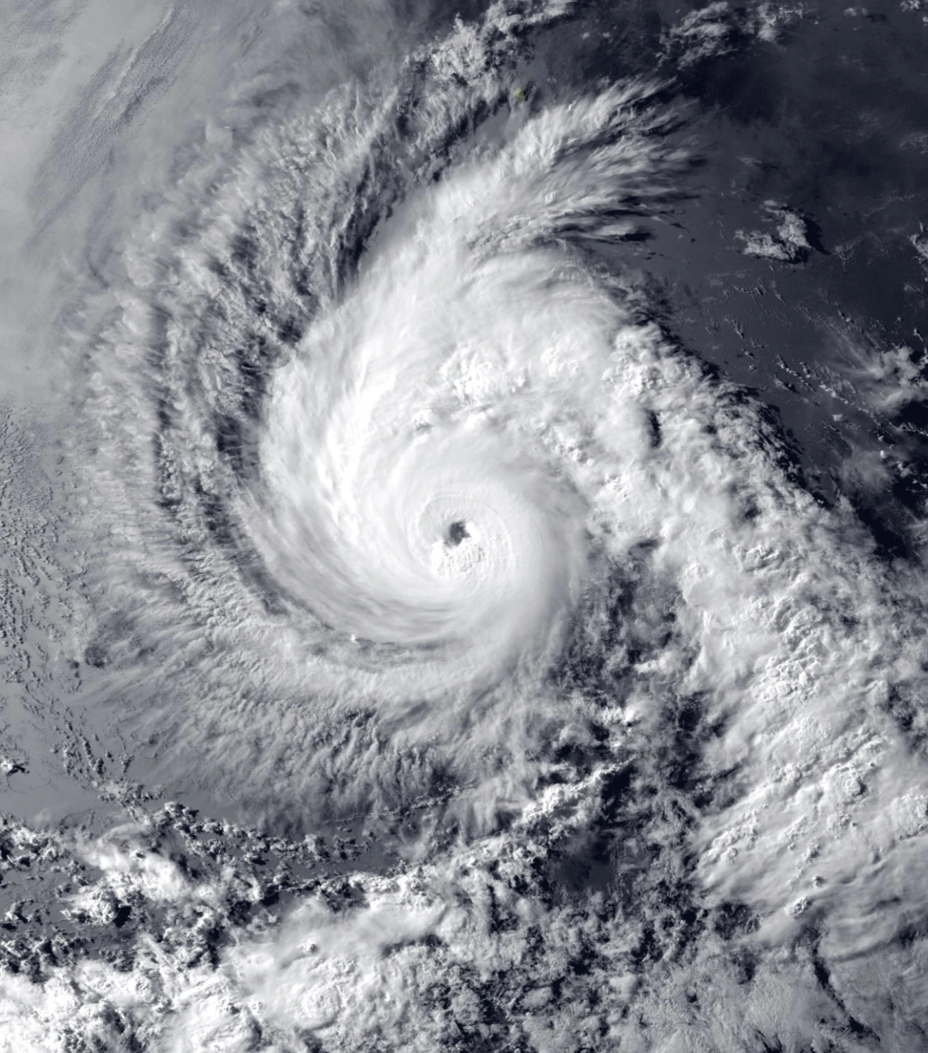
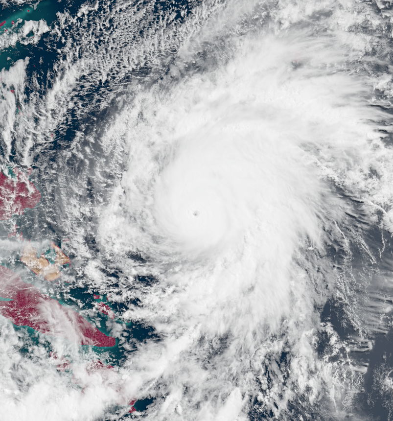
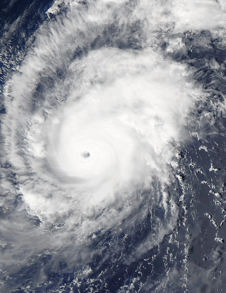
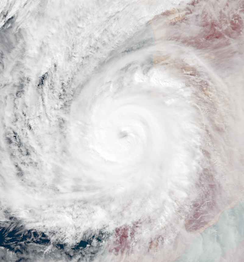
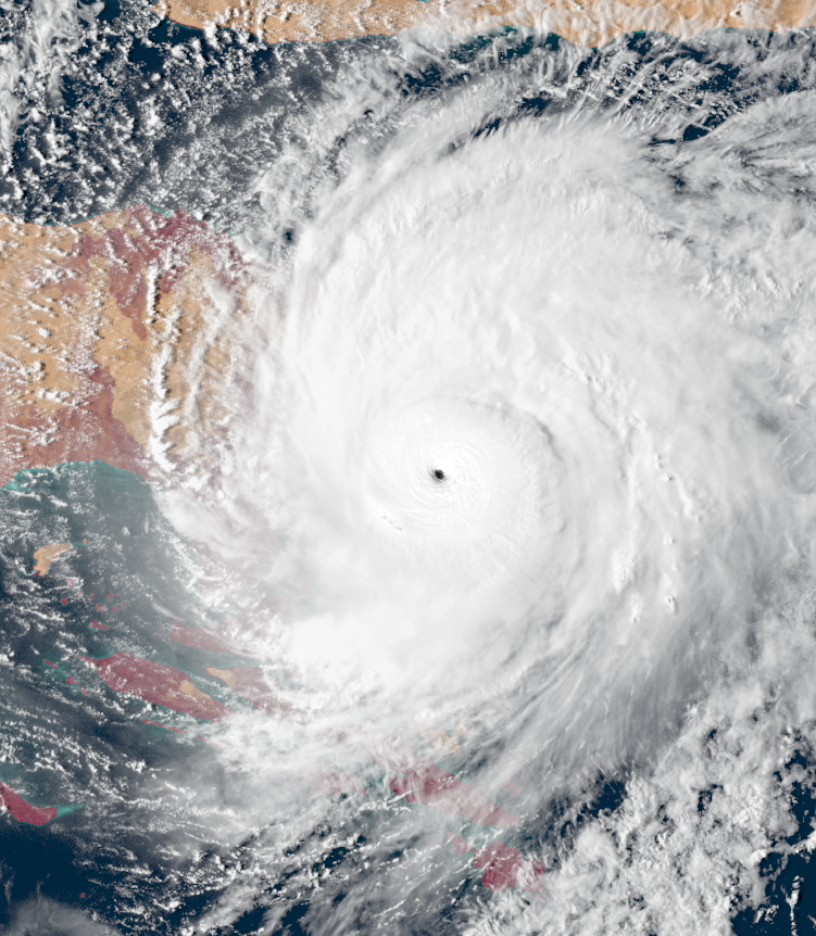
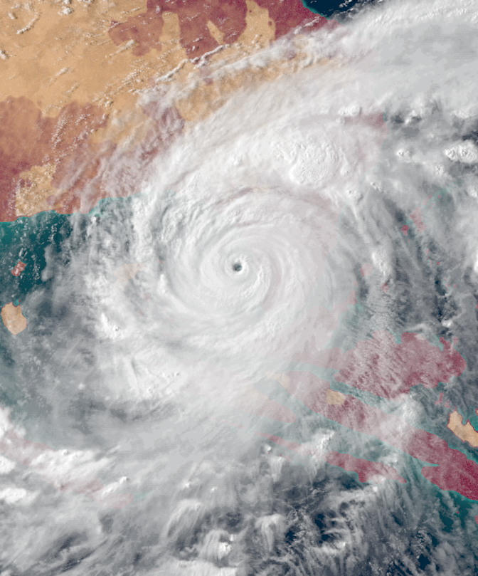
Hyper Tempest Hectavio[]
| Hyper Tempest (EUWS) | |
|---|---|
| Category 5 Uingffhicane (SSHWS) | |
  | |
| Duration | Urvette 30 – Aurelius 15 |
| Peak intensity | 320 mph (515 km/h) (1-min) 779 mbar (hPa) |
On Urvette 29, a tropical wave formed in the open Apolingffhian basin. The system initially struggled to develop due to a cold wake left by Tempest Fragilia, but it eventually formed into an irregularity at 18:00 UTC on Urvette 30. Being named Hectavio the day after, the storm began to move west, where it began to strengthen steadily. On Aurelius 4, Hectavio achieved winds of 160 mph, a Category 5, before making landfall on Neo Caribbea Central the same day as a C4. Hectavio proceeded to move over the Neo Caribbean Isles for several days as a C4 until Aurelius 7. That day, Hectavio entered the infamous Gulf of Neo Mexico whose warm waters caused Hectavio to begin a period of explosive intensification. Hectavio became a hyper tempest on Aurelius 9, the first of the season, as it curved towards Neo Louisiana. Class IX and Class X warnings were hoisted all over the province in anticipation of a catastrophe. Though Hectavio underwent an eyewall replacement cycle that temporarily weakened it, the warnings remained in effect. On Aurelius 10, the storm re-gained hyper tempest strength and reached its peak intensity of 320 mph. At peak, Hectavio's gale-force wind diameter measured nearly 1,000 miles (1,609 kilometers) wide. That day, Hectavio hit a few dozen miles west of Neo Orleans at peak intensity. Afterwards, the storm weakened slowly while curving northeast, eventually dissipating five days later over Neo York.
Hectavio was one of the worst catastrophes to ever affect Neo Louisiana. Its slow movement and incredible strength resulted in tons of damage and an inconceivable amount of fatalities. Wind shields and flood barriers in the city of Neo Orleans were destroyed with ease, leading to flooding up to 70 feet deep in places due to the city's low elevation. Over 89 inches of rain were recorded in some areas due to Hectavio stalling, which contributed to the flooding. This flooding totally drowned all buildings with less than three stories, while all larger buildings were torn apart by the high winds. The winds also turned whole skyscrapers into projectiles, laid entire forests bare, and radically altered coastlines to the point of being unrecognizable. Though Neo Orleans was the center of the impact, severe damage from both winds and flooding also occurred elsewhere in the province, as Hectavio was slow to weaken. Unlike Emblem and Fragilia earlier in the month, people heeded evacuation orders, but this proved to be futile due to Hectavio's slow weakening rate and travel distance being underestimated. Evacuation centers ended up being exposed to the storm, and many were destroyed. Though transports did arrive to bring people in the centers to safer locations, they were significantly delayed by Glorazia-24, and many were left to die in the centers. Neo Cuba and Neo Jamaica were also affected by Hectavio, but the storm was not strong enough to pierce those areas' wind shields, so damage there remained minimal. Overall, Hectavio caused $1.32 trillion in damages and 924,367 fatalities.
Hectavio was the earliest hyper tempest to ever form in a season, beating the previous record holder (Palia) by 9 days.
Uingffhicane Idyssia[]
| Category 3 Malakas Uingffhicane (EUWS) | |
|---|---|
| Category 3 Uingffhicane (SSHWS) | |
  | |
| Duration | Urvette 30 – Aurelius 7 |
| Peak intensity | 115 mph (185 km/h) (1-min) 964 mbar (hPa) |
On Urvette 29, a tropical disturbance developed a few miles off the coasts of Neo Cuba and Neo Puerto Rico and began to track westward. Eventually, it developed into an irregularity at 22:00 UTC on Urvette 30 and became Tropical Swirl Idyssia the next day. Thereafter, Idyssia began to move northward into the Gulf of Neo Mexico, where it intensified into a uingffhicane on Aurelius 2. ON Aurelius 4, Idyssia became a malakas uingffhicane as it began showing signs of an eye forming. On the 5th, Idyssia achieved peak winds of 115 mph. Though the storm was expected to intensify further into a C4 and hit Neo Orleans, a sudden change in wind currents and conditions caused Idyssia to turn west abruptly before explosively weakening. Idyssia dissipated on the 7th without making any significant landfalls.
Idyssia was originally forecasted to hit Neo Louisiana just a few days before another storm, Hectavio, was expected to hit at a similar intensify, marking the first time in Apolingffhian history that two storms were expected to hit the same place at nearly the same time. Numerous Class V Orange Alerts and Class VI Orange Emergencies were hoisted for the province. However, this predicted scenario ended up becoming untrue, as Idyssia unexpected weakened and turned away from land before landfall while Hectavio went on to strengthen into a hyper tempest. Idyssia's impacts were minimal since wind shields and flood barriers were able to protect cities from the storm's effects. No deaths were reported.
Uingffhicane Jebediah[]
| Category 3 Malakas Uingffhicane (EUWS) | |
|---|---|
| Category 3 Uingffhicane (SSHWS) | |
  | |
| Duration | Aurelius 14 – Aurelius 20 |
| Peak intensity | 115 mph (185 km/h) (1-min) 961 mbar (hPa) |
On Aurelius 14, an area of low pressure formed a few miles northeast of Neo Miami and formed into a tropical cyclone at 17:00 UTC that day. Moving northeast, the newly-named Tropical Swirl Jebediah rapidly intensified due to favorable conditions. On Aurelius 16, Jebediah reached its peak intensity of 115 mph and 961 mbar in the waters between eastern Neo Gaia and Neo Bahamas. After that, Jebediah weakened down into a tropical swirl due to cooler waters and higher wind shear, but continued to persist despite forecasts to dissipate. On Aurelius 18, Jebediah managed to regain severe tropical swirl status, but weakened again quickly after and dissipated two days later.
Jebediah caused only minimal damage thanks to wind shields and flood barriers, but two people drowned due to rip currents created by the uingffhicane.
Severe Tropical Swirl Kasra[]
| Severe Tropical Swirl (EUWS) | |
|---|---|
| Tropical Storm (SSHWS) | |
  | |
| Duration | Aurelius 18 – Aurelius 22 |
| Peak intensity | 60 mph (95 km/h) (1-min) 1000 mbar (hPa) |
On Aurelius 17, a cluster of thunderstorms developed around a hundred miles north of Neo Mexico. At 13:00 UTC on Aurelius 18, it organized enough for the ADSUB to designate it as an irregularity. Initially, it stalled and briefly attained TS status (being named Kasra in the process) on the 19th, but then began moving north while weakening back to an irregularity. On Aurelius 20, Kasra became a tropical swirl once more as it approached the Kersinge Isles. The next day, the storm made landfall on the isles before achieving a peak intensity of 60 mph and 1000 mbar. Afterwards, wind shear caused Kasra to rapidly weaken, becoming a remnant low by the 22nd over Neo Mexico.
Since all of the impacted areas were remote, Kasra caused minimal damage and no deaths.
Severe Tropical Swirl Lukana[]
| Severe Tropical Swirl (EUWS) | |
|---|---|
| Tropical Storm (SSHWS) | |
  | |
| Duration | Aurelius 18 – Aurelius 26 |
| Peak intensity | 70 mph (110 km/h) (1-min) 985 mbar (hPa) |
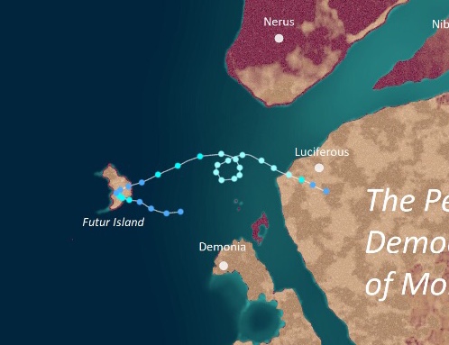
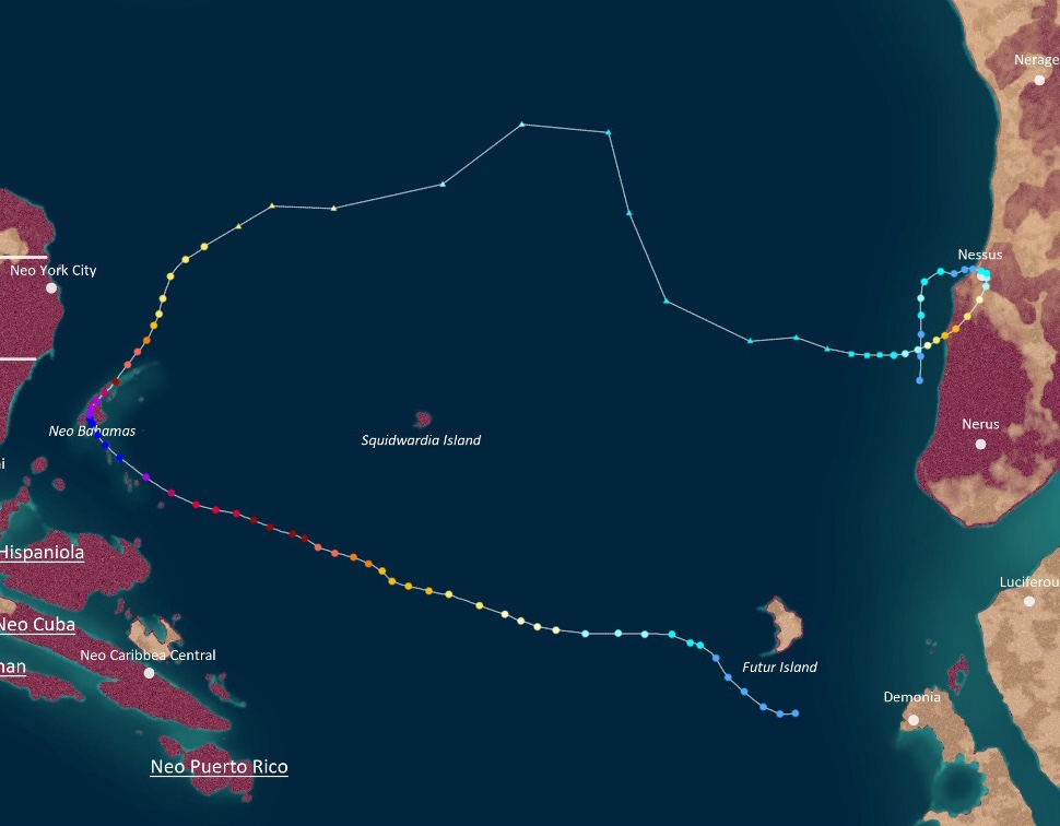
On Aurelius 18, a tropical wave east of Futur Island quickly organized into a tropical irregularity at 21:00 UTC. The next day, it intensified into Tropical Swirl Lukana before making a rare tropical swirl landfall on Futur Island itself. Then, after stalling for a few days over the island, Lukana exited Futur Island as a weak irregularity on Aurelius 21, though it quickly re-strengthened into a swirl later that day. On Aurelius 22, Lukana become a severe tropical swirl and began to make a cyclonic loop. During this loop, Lukana reached its peak of 985 mbar and 70 mph on Aurelius 23. After the loop, Lukana began approaching Morbidia, triggering Class I Blue Alert. Eventually, on Aurelius 25, Lukana hit Morbidia with winds of 65 mph before dissipating insland the next day. Its remnants ended up contributing to the formation of Tempest Nick the next day.
Lukana was notable for its highly unusual track, hitting two areas not known for storm landfalls. In Futur Island, damage was minimal thanks to flood walls and wind barriers, but a record amount of rainfall was recorded in the area - a total of 32 inches of rain fell on the island. Its Morbidia landfall, meanwhile, caused some damage since the Morbidians were unprepared for the landfall. However, it was limited to only $53 million and 5 deaths since its landfall location was rather remote, with the sole nearby major city, Luciferous, being protected by flood barriers and a wind shield.
Uingffhicane Mesmo[]
| Category 1 Uingffhicane (EUWS) | |
|---|---|
| Category 1 Uingffhicane (SSHWS) | |
  | |
| Duration | Aurelius 21 – Aurelius 25 |
| Peak intensity | 85 mph (135 km/h) (1-min) 984 mbar (hPa) |
On Aurelius 20, an area of low pressure developed several hundred miles northwest of Futur Island. Eventually, it organized into a tropical irregularity on Aurelius 21 at 05:00 UTC. The next day, the system became a tropical swirl and was given the name Mesmo by the ADSUB. Moving east towards Kelargar, Mesmo steadily intensified, eventually peaking as a well-organized Category 1 uingffhicane on Aurelius 24. The next day, Mesmo began to rapidly weaken while accelerating. Shortly after hitting Kelargar as a severe tropical swirl, the cyclone dissipated inland.
Mesmo did not cause any damage, but it did crash an outdoor party of Glorazia-skeptic tabulons who were purposefully breaking stay-at-home orders and social distancing guidelines. Nobody died, but it forced the group to call for rescue from authorities, who then gave the involved persons a fine for breaking rules. A few days later, all of them contracted Glorazia-24 with four of them dying, and the infamous "Mesmo Party" became a popular reminder for people to take the Glorazia virus seriously. However, since the four deaths were not caused by Mesmo itself, they were not counted in season totals.
In addition to the party, the storm was notable for sharing its name with that of the ring (somale term for king/queen) of Kaywell, Mesmo Kerolon Kaywell. However, since fe is not a controversial ruler, very few people made memes or references with the storm unlike Tempest Gerolaze of the previous month. Well, except for former prime minister Sentar Kraglathea since he is always a jerk. (How on earth did he even win enough votes to get elected, anyway? Not even members of fir own party support fir!)
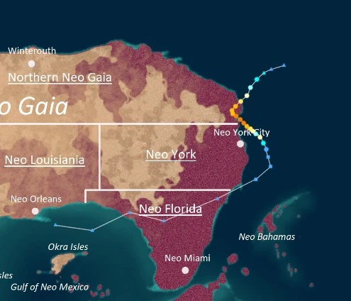
Tempest Nick[]
| Stage 5 Tempest (EUWS) | |
|---|---|
| Category 5 Uingffhicane (SSHWS) | |
  | |
| Duration | Aurelius 27 – Septavia 20 |
| Peak intensity | 295 mph (475 km/h) (1-min) 780 mbar (hPa) |
On Aurelius 26, a large tropical wave merged with the remnants of Severe Tropical Swirl Lukana and emerged from the coast of Morbidia. Quickly organizing, the storm was designated an irregularity at 19:00 UTC on Aurelius 27 while south of Futur. On Aurelius 29, the irregularity was designated Tropical Swirl Nick after a recon flight found gale-force winds in the core. Thereaster, Nick slowly intensified, becoming a uingffhicane on the 30th and a malakas uingffhicane on Septavia 2. Starting on Septavia 4, Nick began to rapidly intensify, becoming a tempest that day. Soon, Nick became a Stage 5 on Septavia 6 while approaching Neo Bahamas, triggering Class VIII Red Emergencies for the islands. On Septavia 7, Nick reached its peak intensity of 295 mph and 780 mbar while boasting a large wind field roughly 1000 miles wide before hitting Neo Bahamas at peak intensity. Afterwards, Nick began to weaken, losing tempest status on the 9th and losing malakas uingffhicane status on the 10th. Though the storm stabilized as a Category 2, Nick eventually became extratropical early the next day.
However, on Septavia 14, the extratropical remnants of Nick began to regain tropical characteristics off the coast of Kelargar and regenerated into a subtropical swirl that day. Later, the storm became fully tropical and strengthened further into a uingffhicane on Septavia 15. On Septavia 16, Nick reached its secondary peak intensity of 120 mph and 960 prior to making landfall on Kelargar. Over land, Nick stalled for nearly two days while making an anticyclonic loop, passing over Nessus City as a severe tropical swirl. On the 18th, the storm re-entered the open ocean as a mere irregularity, but managed to re-intensity yet again. On Septavia 19, Nick reached its third and final peak intensity as a 60 mph severe tropical swirl before dissipating for good the following day.
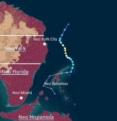
Tempest Nick was one of the worst storms to strike Neo Bahamas. Very strong waves, rip currents, and storm surges radically altered the shapes of many of the islands. Numerous islands ended up being temporarily submerged, with any buildings on them inundated and destroyed. Flood barriers proved to be useless against the tempest, as they were either not high enough or ended up collapsing due to their sandy foundations becoming unstable. Furthermore, many islands which served as important habitats for endangered wildlife were destroyed, causing harm to the local ecosystems of Neo Bahamas. In addition to flooding, Nick's exceptionally high 300+ mph wind gusts destroyed any wind shields on the islands with ease, battering the already-damaged buildings with airborne debris and wind gusts. An archipelago-wide power outage occurred due to power stations being destroyed by the storm, leaving millions in the dark. Unfortunately, much like with previous severe storms during the year, the people of Neo Bahamas were unable to evacuate efficiently due to air travel being inhibited by Glorazia-24 restrictions, leading to a very high death toll. In addition to Neo Bahamas, Neo Hispaniola, Neo Florida, Neo York, and Northern Neo Gaia all reported gusty winds, rip currents, and heavy rain. Nessus City was also affected by Nick when it regenerated into a C3, with over 29 inches of rain falling over the area, but damage was only minimal there thanks to advanced technology. Overall, Nick caused $500.8 billion in damages and 14,253 deaths.
Tempest Okra[]
| Stage 3 Tempest (EUWS) | |
|---|---|
| Category 5 Uingffhicane (SSHWS) | |
  | |
| Duration | Aurelius 29 – Septavia 8 |
| Peak intensity | 260 mph (420 km/h) (1-min) 839 mbar (hPa) |
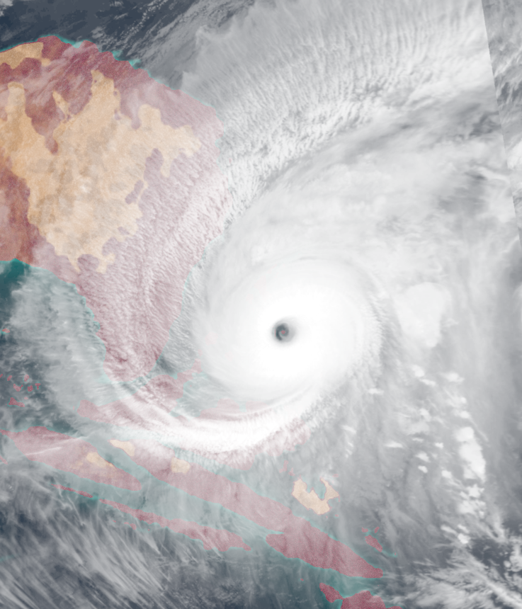
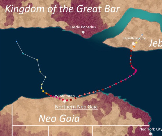
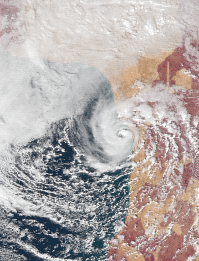
On Aurelius 28, an extratropical low south of the UKGB formed and explosively strengthened into a C2-equivalent cyclone. Later, the powerful storm began to exhibit signs of a tropical transition. Eventually, the storm formed into Subtropical Uingffhicane Okra at 15:00 UTC on Aurelius 29 (Note: Unlike on Earth, hurricane/uingffhicane-force subtropical cyclones are officially recognized by the ADSUB) and became a fully tropical category 3 malakas uingffhicane later that day. The next day, Okra underwent a period of explosive intensification, wiht its winds increasing by 135 mph (215 km/h) over the course of roughly 24 hours, becoming the northernmost tempest ever recorded. Shortly after reaching its first peak at a 245 mph stage 3 tempest, Okra made an exceptionally rare Northern Neo Gaia landfall, marking the first time a tempest has ever made direct landfall on the province. Afterwards, Okra began weakening due to land interaction but remained strong, passing over the city of Winterouth as a Stage 2 on Septavia 1. The day after, Okra emerged back into the open Apolingffhian as a Category 5 while undergoing an eyewall replacement cycle. On Septavia 3, Okra transitioned into an annular tropical cyclone while regaining tempest strength. As the storm moved north, Okra reached its peak of 260 mph and 839 mbar on Septavia 5 over the waters between Northern Neo Gaia and Jebellion, breaking its own record of northernmost tempest. Class VII Red Alerts and later Class VIII Red Emergencies were issued for Jebellion City, the first time tropical cyclone warnings had even been issued for Jebellion. Soon, on Septavia 7, Okra made landfall near Jebellion City as a 195 mph T1. Then, Okra rapidly weakened over land, dissipating on Septavia 8 less than 18 hours after landfall.
Okra was a highly unusual tropical cyclone that impacted several areas not accustomed to uingffhicane landfalls. As such, damage was very severe. In Winterouth, every single building was demolished even before the onset of tempest winds, as no wind shields had been set up in the city due to the unlikelyhood of a tropical cyclone landfall. Storm surge was not a huge problem in Winterouth since the city was relatively inland, but flooding still left its mark, with many rivers overtopping their banks. Around 2.3 million customers lost power during the storm. As for Jebellion, damage was surprisingly light since Okra had rapidly weakenedby the time it reached a major city, though rainfall and wind records were still broken. Also, since Jebellion had been Glorazia-free thanks to the country's relative sparse population and very effective safety measures brought about by its prime minister, Moh Ira, evacuation was able to take place smoothly. Overall, Okra caused a total of $78 billion in damages and 187 fatalities - damage and deaths were relatively low since the locations it hit were sparsely populated, but they were still a record for the area.
Uingffhicane Pavilion[]
| Category 2 Uingffhicane (EUWS) | |
|---|---|
| Category 2 Uingffhicane (SSHWS) | |
  | |
| Duration | Septavia 1 – Septavia 10 |
| Peak intensity | 110 mph (175 km/h) (1-min) 962 mbar (hPa) |
On Aurelius 29, an area of low pressure formed off the coast of western Neo Florida and steadily organized. By 03:00 UTC on Septavia 1, the system had organized enough to be declared a tropical irregularity by the ADSUB. Afterwards, the system moved west as it continued to organize, becoming Tropical Swirl Pavilion the next day. By Septavia 4, Pavilion had been upgraded into a severe tropical swirl and by Septavia 5, a category 1 uingffhicane. Early the next day, Pavilion began to rapidly intensify and became a Category 2 uingffhicane. However, a sudden influx of medium wind shear and slightly cooler waters caused Pavilion to top off at 110 mph and 962 mbar. This intensity remained constant for several days as Pavilion made an erratic turn east, with numerous Class III and Class IV warnings being hoisted for Neo Florida. After reaching a minimum pressure of 962 mbar on Septavia 7, Pavilion made landfall on Neo Florida late that day. Thereafter, the storm curved north-northwest as it began to weaken from both land interaction and wind shear from the nearby and much more powerful Tempest Roblox. Eventually, Pavilion was absorbed completely into Roblox the next day.
Pavilion caused only minimal damage thanks to wind shields and flood barriers, though one person died due to recklessly driving out during the storm and getting caught in a swollen river.
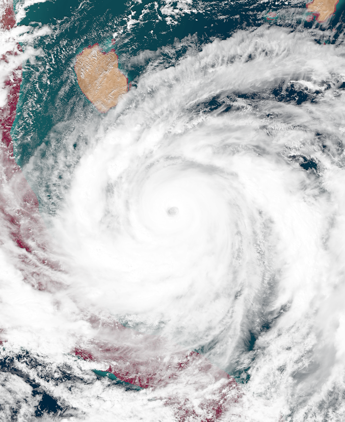
Hyper Tempest Roblox[]
| Hyper Tempest (EUWS) | |
|---|---|
| Category 5 Uingffhicane (SSHWS) | |
  | |
| Duration | Septavia 2 – Septavia 14 |
| Peak intensity | 375 mph (605 km/h) (1-min) 716 mbar (hPa) |
On Septavia 1, a well-organized tropical wave emerged from the coast of Morbidia. Though it initially struggled to develop a circulation, the system eventually became a tropical irregularity at 21:00 UTC on Septavia 2. The next day, the irregularity received the name Roblox due to becoming a tropical swirl. As the swirl began to move northwest, it began to quickly gain strength. By Septavia 4, Roblox had intensified into a uingffhicane. Shortly after, Roblox entered an area where conditions were more than ripe for explosive intensification. On Septavia 5, Roblox achieved both malakas uingffhicane status and tempest status while developing a well-defined pinhole eye. Roblox went on to achieve an initial peak intensity of 285 mph on Septavia 7, but underwent an eyewall replacement cycle that caused it to weaken temproarily into a Stage 3 tempest. However, Roblox quickly re-strengthened before reaching its true peak of 375 mph and 716 mbar on Septavia 9, the second hyper tempest of the season, and absorbed the remnants of Uingffhicane Pavilion in the process. While doing so, Roblox grew to an enormous size of over 2,000 miles in diameter, matching Infinite Tempest Palia of the previous year's record for largest tropical cyclone on record in Apolingffh (though both it and Palia would be beaten by Infinite Tempest Campanella the same year). Neo Bahamas experienced 200+ mph sustained winds despite being more than a hundred miles away from the eyewall. After making a turn to the northeast, Roblox' convection began to wane as cooler waters and wind shear began to take their toll. Roblox lost tempest strength on Septavia 12 as it began moving northwest again. Two days later, on the 14th, Roblox became extratropical. Its remnants went on to hit Jebellion Island and the Great Bar as a severe blizzard and windstorm.
Roblox never made any true landfall, but its large size enabled its effects to stretch far and wide, with rough surf and stormy conditions being experienced in Neo Caribbea, Neo Florida, Neo York, and Northern Neo Gaia. Neo Bahamas was the area that recieved the worst effects from Roblox, as the islands were close enough to the eyewall of Roblox to experience tempest-force winds. However, since the area had already been thoroughly destroyed by Tempest Nick, damage there was lower than what is usual for hyper tempests. However, there was still significant disruption in the form of halted rescue and recovery operations along with the destruction of any surviving structure. In addition to this, Roblox caused severe damage to Jebellion and the UKGB as an extratropical windstorm, with numerous structures experiencing significant damage and severe snow. Wind gusts of over 100 miles per hour were recorded in numerous places while visibility was near zero, producing horrendous conditions. Numerous vehicle accidents occurred in the two nations, killing dozens. Also, power supply for a total of 10 million people went out thanks to the snow. Power was unable to be restored for several days due to the snow and winds making it essentially impossible to drive safely. This led to water shortages and famine amongst Jebellians and Great Bar citizens that not even good leaders like Moh Ira were able to do something about. Overall, Roblox killed 2,316 people and caused $140 billion in damages.
The use of the name "Roblox" for the storm generated some media attention associating it with Roblox, an online game popular yet controversial amongst humans. Some poked fun at the storm for a short time, but this stopped after a stern speech from Jebellion prime minister Moh Ira, whose country was devastated by Roblox, condemning the jokes as insensitive. Meanwhile, the popularity of the game Roblox skyrocketed downwards due to superstitious people associating the game with the storm. The previous tally of 265 million active Roblox users on Uingffh dwindled down to a mere 98 million. However, its popularity gradually increased. But it then went down to 0 active users in 0025 since all life in existence became extinct that year thanks to extremely powerful black holes.
Tropical Swirl Sancha[]
| Tropical Swirl (EUWS) | |
|---|---|
| Tropical Storm (SSHWS) | |
  | |
| Duration | Septavia 4 – Septavia 6 |
| Peak intensity | 50 mph (85 km/h) (1-min) 994 mbar (hPa) |
Early on Septavia 4, a frontal low formed southeast of Squidwardia Island. Due to favorable conditions, the system underwent a tropical transition and became a subtropical irregularity at 14:00 UTC that day. The following day, the subtropical irregularity intensified into Subtropical Swirl Sancha and became fully tropical by noon. Later that day, Sancha peaked with winds of 50 mph and a central pressure of 994 mbar, a strong tropical swirl, before beginning to weaken. By midnight on Septavia 6, Sancha had degenerated into a trough.
Sancha caused some rough surf along Squidwardia Island, but no deaths were reported.
Uingffhicane Torgenia[]
| Category 2 Uingffhicane (EUWS) | |
|---|---|
| Category 2 Uingffhicane (SSHWS) | |
  | |
| Duration | Septavia 12 – Septavia 17 |
| Peak intensity | 100 mph (160 km/h) (1-min) 977 mbar (hPa) |
On Septavia 9, a tropical wave emerged from the coast of Morbidia and trekked across the open ocean for several days. Despite optimal water temperatures, outflow from the much stronger Hyper Tempest Roblox prevented formation until 02:00 UTC on Septavia 12, when the system was located a few miles off the western coast of Neo Puerto Rico. Later that day, the newly-designated irregularity strengthened into a tropical swirl and received the name Torgenia. Though the storm was forecasted to make landfall on Neo Caribbea, Torgenia instead turned slightly west and wove through the waters between Neo Cuba, Neo Cayman, and Neo Jamaica. On Septavia 13, Torgenia became a uingffhicane and by Septavia 14, it had reached its peak intensity as a minimal Category 2 uingffhicane with winds of 100 mph and a central pressure of 977 mbar while in between Neo Cuba and Neo Cayman. As drier air began to weaken the system, Torgenia continued to stay in the narrow straits between the Neo Caribbean islands. On Septavia 17, Torgenia dissipated without having made any true landfall.
Torgenia only caused minimal damage and 7 deaths thanks to the protection of the tabulons' flood barriers and wind shields, but it was still notable for its erratic track that took it into the thin passages between the Neo Caribbean Islands, narrowly avoiding landfall. Meteorologists have called such an event a once-in-a-lifetime occurrence.
Severe Tropical Swirl Verona[]
| Severe Tropical Swirl (EUWS) | |
|---|---|
| Tropical Swirl (SSHWS) | |
  | |
| Duration | Septavia 13 – Septavia 18 |
| Peak intensity | 65 mph (105 km/h) (1-min) 996 mbar (hPa) |
On Septavia 11, a tropical wave began to form off the coast of Morbidia and drifted west for several days. Eventually, at 17:00 UTC on Septavia 13, the system developed into an irregularity while over the middle of the Apolingffhian. The following day, it strengthened into Tropical Swirl Verona while continuing to move in a general west direction. Verona reached its peak intensity as a 65 mph STS on Septavia 16 before wind shear and cooler waters caused the storm to dissipate on the 18th a few dozen miles east of Neo Hispaniola.
Verona brought rough surf to the coasts of Neo Puerto Rico, Neo Cuba, and Neo Hispaniola. However, no damage or deaths were reported.
Tropical Swirl Wilhelmnia[]
| Tropical Swirl (EUWS) | |
|---|---|
| Tropical Swirl (SSHWS) | |
  | |
| Duration | Septavia 16 – Septavia 18 |
| Peak intensity | 45 mph (70 km/h) (1-min) 998 mbar (hPa) |
A frontal low over the open Apolingffhian Ocean began to gain tropical characteristics on Septavia 15. Eventually, it became an irregularity at 23:00 UTC on Septavia 16 a few dozen miles southwest of Squidwardia Island. Afterwards, the system began making an unusual move southward as it achieved tropical swirl status the next day, receiving the name Wilhelmnia. Wilhelmnia peaked on Septavia 17 with winds of 45 mph and a central pressure of 998 mbar before wind shear destroyed the storm on Septavia 18.
Wilhelmnia brought some light rain to Squidwardia, but no damage or deaths occurred.
Tempest Xectorvia[]
| Stage 3 Tempest (EUWS) | |
|---|---|
| Category 5 Uingffhicane (SSHWS) | |
  | |
| Duration | Septavia 20 – Septavia 25 |
| Peak intensity | 245 mph (395 km/h) (1-min) 855 mbar (hPa) |
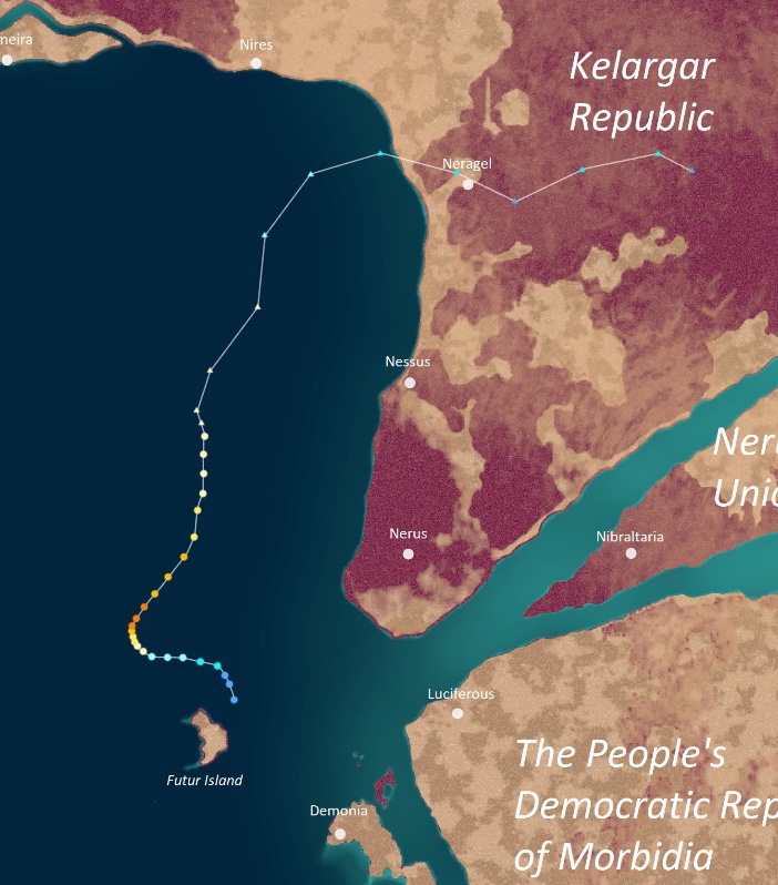
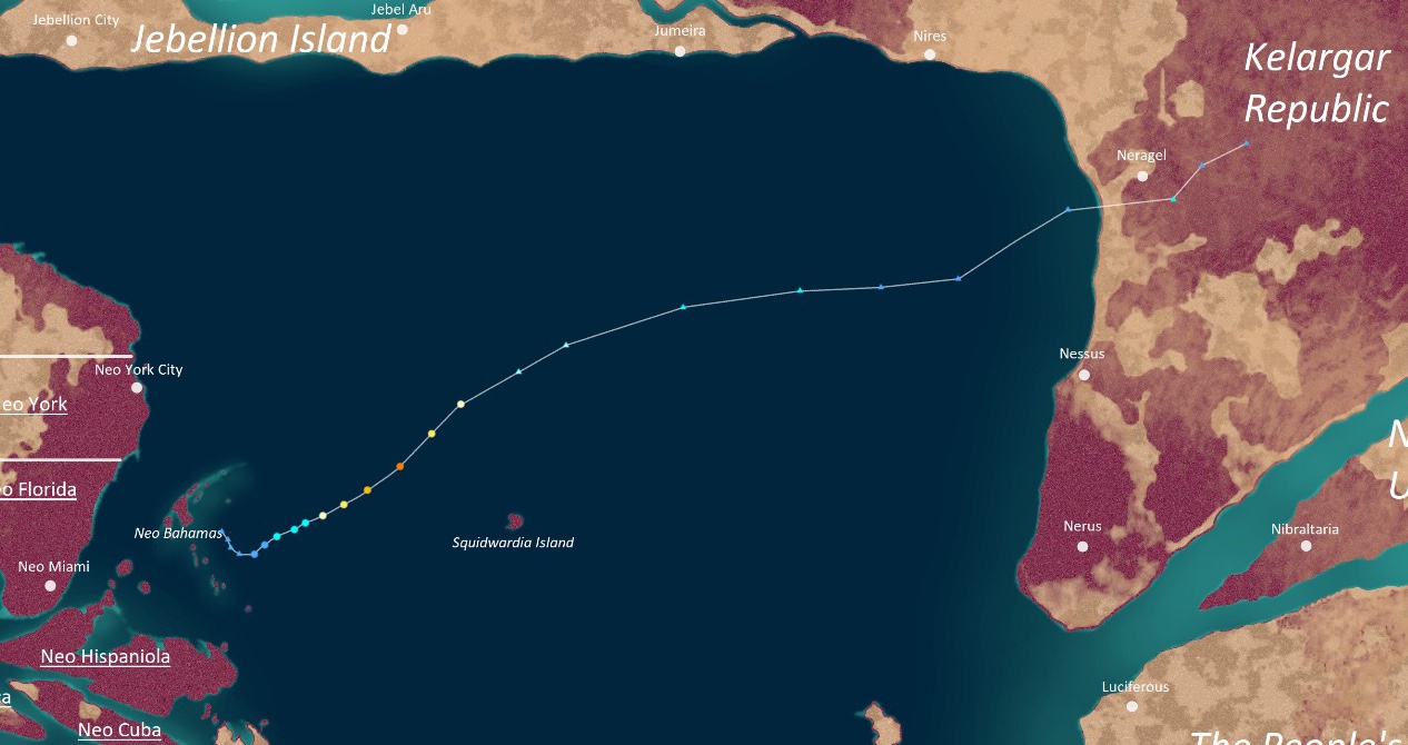
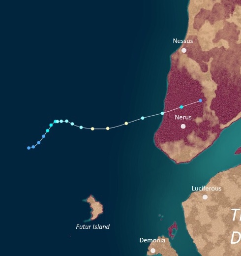
On Septavia 17, a large and powerful extratropical cyclone formed and moved across the northern Apolingffhian Ocean, bringing uingffhicane-force winds to Jumeira and northern Kelargar in the process. On Septavia 20, the ADSUB detected signs of a small tropical system forming within the cyclone, leading to the designation of Severe Tropical Swirl Xectorvia at 20:00 UTC on Septavia 20. This made the system the record second system to form at an unusually high latitude, with the other being Tempest Okra. Xectorvia eventually completed its tropical transition the next day, but its unusual location caused it to weaken back into a tropical swirl. On Septavia 22, however, Xectorvia passed over an area of unusually favorable conditions, causing it to rapidly intensify and become a uingffhicane that day. After becoming a tempest on Septavia 23, Xectorvia reached its T3 peak of 245 mph on Septavia 24, becoming the second northernmost tempest on record beaten only by Okra. Later that day, Xectorvia made landfall on Neragel before rapidly dissipating on the 25th.
On top of being a highly unusual system developing within a larger extra low, Xectorvia caused massive destruction while both extratropical and tropical. The system's parent extratropical cyclone brought severe winds and rain to Jebellion, the UKGB, and the parts of Kelargar on the Great Bar. Jumeira, a city in Jebellion, recorded sustained winds of over 105 mph, which is equivalent to a Category 2 uingffhicane. Thousands of trees were downed while many buildings sustained major damage. Damage was worst in Neragel, which had never seen a storm as strong as Xectorvia in hundreds of years. There, despite the storm weakening down to a malakas uingffhicane upon passing over the city, its unusual landfall location caused significant damage. A total of 756,000 structures were damaged in some form while 4.2 million lost power. Meanwhile, the dozens of small coastal towns near the landfall location of the storm were all completely flattened, with even the roads and sidewalks being peeled off. In total, Xectorvia killed 1,879 tabulons and caused $510 billion in damages, making it the worst disaster to ever hit northern Kelargar in history.
Uingffhicane Yacen[]
| Category 4 Uingffhicane (EUWS) | |
|---|---|
| Category 4 Uingffhicane (SSHWS) | |
  | |
| Duration | Septavia 22 – Septavia 28 |
| Peak intensity | 155 mph (250 km/h) (1-min) 933 mbar (hPa) |
On Urvette 21, an area of convection over Neo Cayman developed and rapidly organized, eventually becoming a tropical irregularity at 01:00 UTC on Urvette 22. Later that day, it became Tropical Swirl Yacen as it moved westward towards Neo Mexico. Steadily intensifying, Yacen eventually became a uingffhicane on Urvette 24, which was when the storm began to rapidly intensify. Later that day, Yacen developed a well-organized eye while becoming a malakas uingffhicane. By the 25th, Yacen was a powerful Category 4 uingffhicane with winds of 155 mph. The uingffhicane held C4 status into Urvette 26, but dropped back to C3 status by noon. Near the end of that day, Yacen made landfall several hundred miles southeast of Neo Mexico City with winds of 120 mph. It then rapidly weakened over land, dissipating fully on Urvette 28.
Yacen caused rather severe damage due to hitting several small towns which had not been equipped with wind shields due to Glorazia-24. Multiple homes were swept away by mudslides, landslides, and flash flooding triggered by the storm while high winds tore away rooves and walls. Deaths were amplified by the Neo Mexican government's inability to provide adequate aid for those affected due to the areas affected being known hotspots for the Glorazia virus. Eventually, rescue and medical personnel arrived at the scene, but not in time to prevent the deaths of 923 along with the loss of $14.5 billion to damages. Many of the personnel, as feared, ended up contracting Glorazia-24 after the event as well, making the pandemic worse.
Tempest Zwordelia[]
| Stage 1 Tempest (EUWS) | |
|---|---|
| Category 5 Uingffhicane (SSHWS) | |
  | |
| Duration | Septavia 30 – Octavia 10 |
| Peak intensity | 205 mph (330 km/h) (1-min) 884 mbar (hPa) |
On Septavia 27, a tropical wave formed in the middle of the Apolingffhian and moved west. Though organization was slow due to moderate wind shear, the system eventually became developed enough to be classified as an irregularity by the ADSUB at 19:00 UTC on Septavia 30 east of Neo Hispaniola. The next day, the system became a tropical swirl and was named Zwordelia and by Octavia 2, Zwordelia had become a severe tropical swirl. However, intensification was halted when the storm made landfall on Neo Hispaniola later that day. Zwordelia weakened back into a TS over land, but by a stroke of luck regained severe tropical swirl status on Octavia 4 due to passing over the warm waters of the Neo Hispaniolan Bay. After entering the Gulf of Neo Mexico on Septavia 5, Zwordelia became a uingffhicane and began to rapidly intensify while making a turn northeast. The storm reached its peak intensity of 205 mph and 884 mbar on Septavia 7, making it a Stage 1 tempest on the EUWS. The next day, Zwordelia made landfall on Neo Florida as a minimal Category 5 uingffhicane having weakened slightly due to an eyewall replacement cycle. The storm then weakened over land over the following days and eventually dissipated on Octavia 10 over Neo York.
Like with Yacen, Zwordelia did not cause much damage to the major cities, but did pull a devastating blow on the smaller towns of Neo Gaia. The swirl's strong winds tore off rooves and damaged walls while uprooting miles of vegetation. However, the worst effects came from flooding, as the storm spent over two days over Neo Florida and Neo York. The town of Neo Raleigh alone recieved over 20 inches of rain on Septavia 10. The high rainfall triggered numerous flash floods across Eastern Neo Gaia, with a total of 625,300 structures being affected. Multiple rivers overflowed their banks while numerous crops were destroyed, harming Neo Gaia's economy in the process. Also like Yacen, recovery was lengthy due to fears surrounding Glorazia-24, resulting in a high death toll from starvation, disease, and lack of medical help. These effects were not only felt in Neo Florida and Neo York, but Neo Hispaniola as well since the storm also passed over that province. Overall, Zwordelia caused $34 billion in damages and 888 fatalities.
Zwordelia's formation on Septavia 30 marked the tenth storm to form in Septavia. This set a record for the most storms to ever form in a single month in the Apolingffhian basin, beating the previous record of 9 storms during Urvette of 0023.
Tropical Swirl Aurus[]
| Tropical Swirl (EUWS) | |
|---|---|
| Tropical Swirl (SSHWS) | |
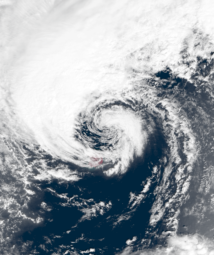 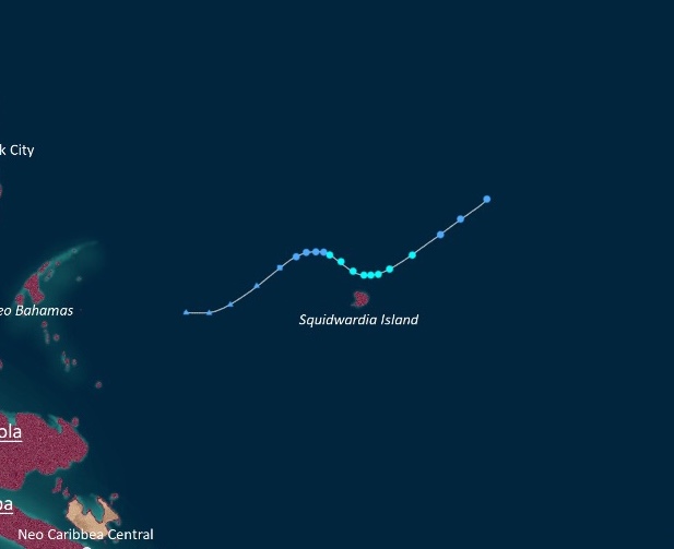 | |
| Duration | Octavia 3 – Octavia 7 |
| Peak intensity | 45 mph (70 km/h) (1-min) 1000 mbar (hPa) |
Early on Octavia 2, a low pressure area along a cold front moved east over the open ocean and began to transition into a tropical cyclone. The ADSUB monitored the system until its eventual development into a subtropical irregularity at 09:00 UTC on Octavia 3. The irregularity soon became tropical that day and further intensified into a tropical swirl on Octavia 4, receiving the name Aurus. Aurus proceeded to make a wavy path while north of Squidwardia island, peaking on Octavia 5 as a rather weak 45 mph, 1000 mbar tropical swirl. As the storm began to be carried northeast into cooler waters by the same cold front it had formed out of, it rapidly weakened. Aurus eventually dissipated on Octavia 7.
Aurus brought heavy rain to Squidwardia Island. One person drowned due to their car getting stranded on a flooded roadway, but otherwise no deaths and only minimal damage was reported. However, Aurus was notable for marking the first full rotation of all 6 ADSUB naming lists.
Severe Tropical Swirl Bonnie[]
| Severe Tropical Swirl (EUWS) | |
|---|---|
| Category 1 Uingffhicane (SSHWS) | |
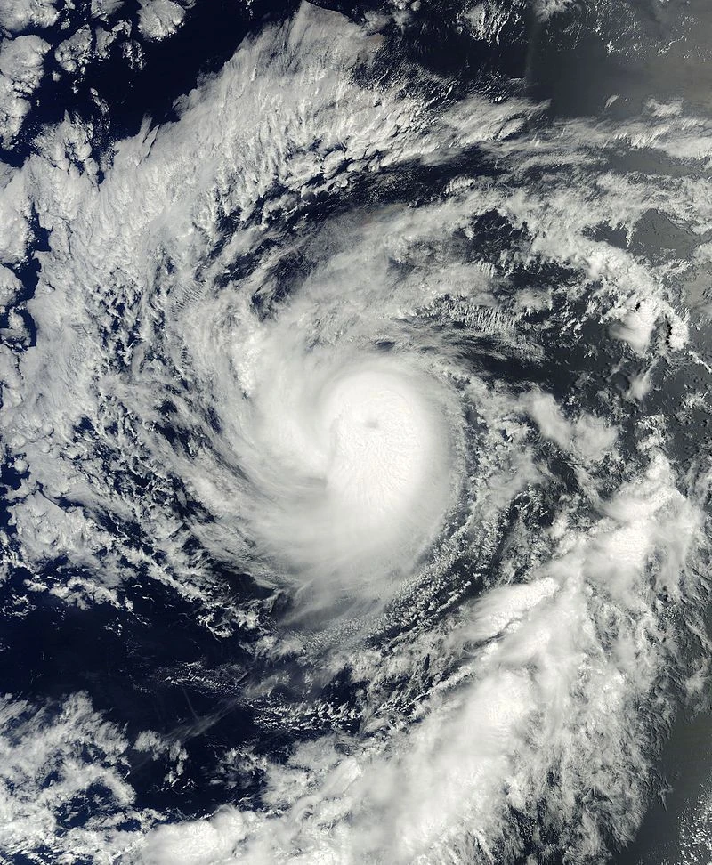 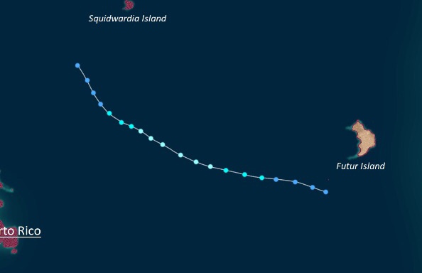 | |
| Duration | Octavia 4 – Octavia 9 |
| Peak intensity | 75 mph (120 km/h) (1-min) 981 mbar (hPa) |
On Octavia 4, a cluster of thunderstorms developed south of Futur Island and began to quickly organize thanks to favorable conditions. At 11:00 UTC that day, it developed into a tropical irregularity and received the name Bonnie on Octavia 5. Moving northwest for its whole life, Bonnie eventually reached its peak intensity of 75 mph and 981 mbar on Octavia 6 while developing a small but well-defined eye. Thereafter, an onset of wind shear began to gradually degrade Bonnie's structure, culimating in its dissipation into a trough on Octavia 9.
As Bonnie stayed far away from land for its entire life, the swirl caused no damage or deaths.
Infinite Tempest Campanella[]
| Infinite Tempest (EUWS) | |
|---|---|
| Category 5 Uingffhicane (SSHWS) | |
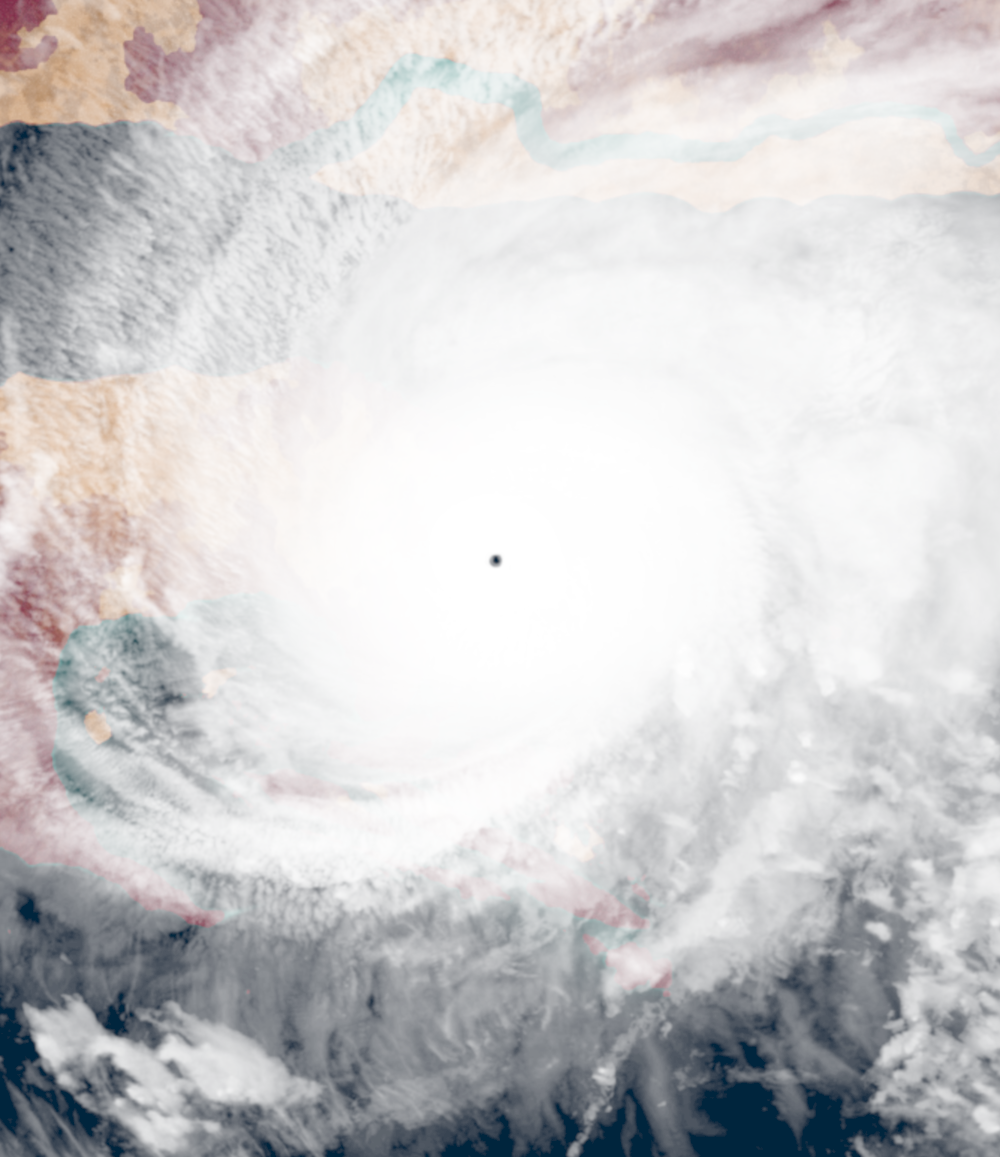 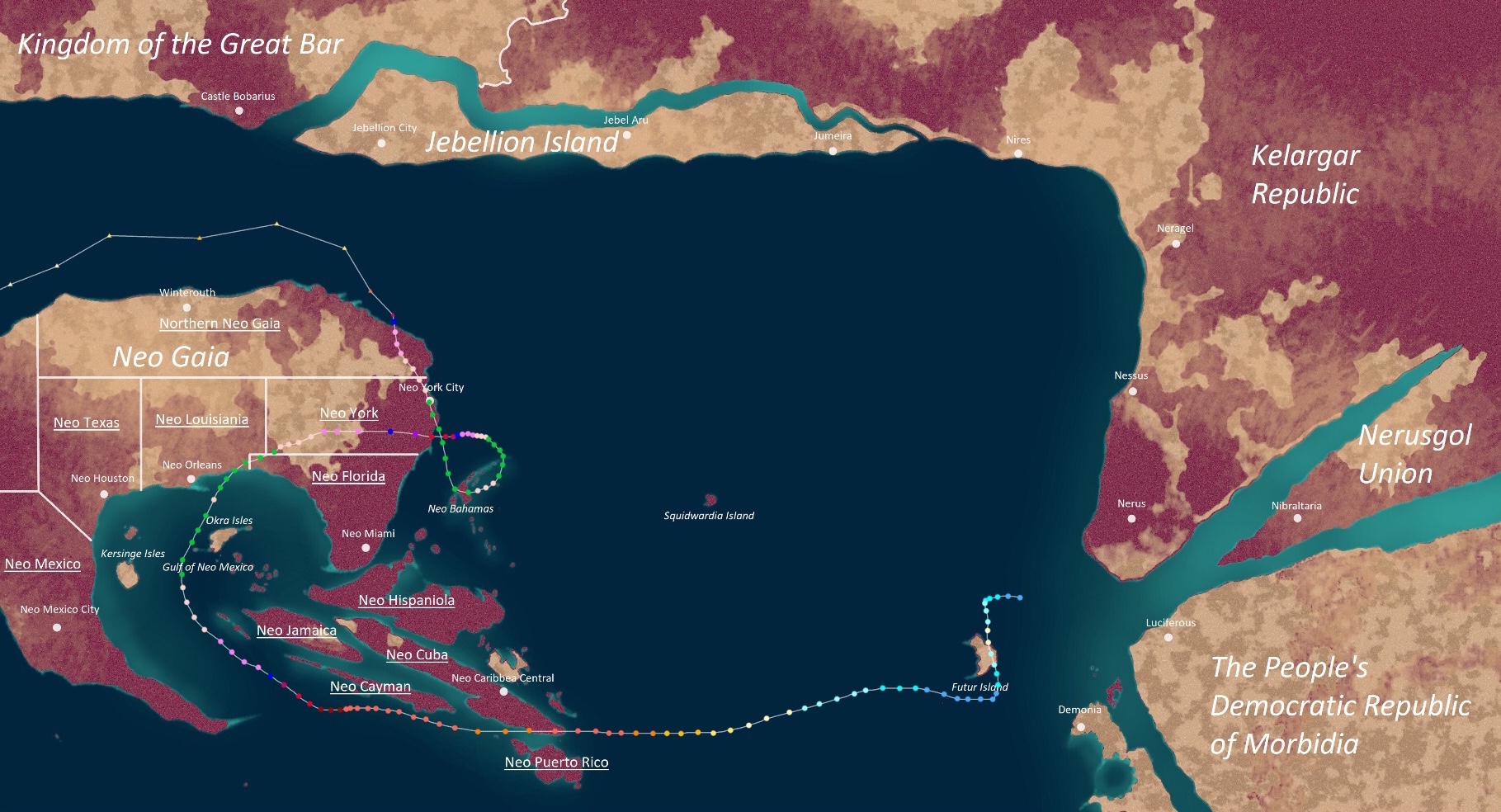 | |
| Duration | Octavia 6 – Thanktavia 8 |
| Peak intensity | 540 mph (870 km/h) (1-min) 543 mbar (hPa) |
Main article: Infinite Tempest Campanella (0024 SC)
On Octavia 6, a tropical wave developed north of Futur Island and immediately began to organize. Only a few hours after formation, it was designated a tropical irregularity by the ADSUB at 23:00 UTC that day. Afterwards, the newly-developed storm began quickly intensifying; on Octavia 8, it became a tropical swirl and was named Campanella, marking the first time the name was used after replacing the name Chi in 0020. By the end of Octavia 8, Campanella had become a Category 1 uingffhicane as it headed south towards Futur Island. The following day, the storm made landfall on Futur Island with winds of 90 mph before weakening over land. By the time it re-entered open waters, Campanella had weakened to a tropical swirl and weakened further into an irregularity on the 10th due to persistent wind shear. The storm then turned west and remained an irregularity, with the ADSUB forecasting a quick dissipation, but it nonetheless persisted. Then, as it moved into more favorable conditions in the west, Campanella began intensifying again and became a TS on Octavia 12. After that, the system began a trend of steady intensification. Campanella gained uingffhicane status on Octavia 14 and malakas uingffhicane stauts on Octavia 15. By Octavia 16, it reached its second peak intensity of 190 mph and 886 mbar, a strong C5. Orange emergencies were issued all over eastern Neo Cuba and Neo Puerto Rico as Campanella approached these areas. On Octavia 17, the powerful uingffhicane made landfall on Neo Cuba's southern tip. Afterwards, Campanella weakened back into a C4 due to land interaction and an eyewall replacement cycle, but it promptly regained its strength and became a Category 5 again on Octavia 18. Campanella remained a C5 for a few days while passing south of Neo Caribbea, but began another period of rapid intensification as it neared the warm waters of the Gulf of Neo Mexico, becoming a tempest on Octavia 21. Then, starting on Octavia 22, Campanella experienced a dramatic increase in strength due to nearly perfect conditions for explosive intensification. After only a few hours, the storm became an exceptionally powerful hyper tempest south of Neo Jamaica, making it the fastest-strengthening storm ever recorded in Apolingffh. However, the storm did not stop there and continued to strengthen very rapidly. On Octavia 24, Campanella became a mega tempest and by the 25th, an infinite tempest, shocking the globe. Its upgrade to infinite tempest status marked the shortest time period between two infinite tempest on record, as the last infinite tempest, Palia, occured only a year prior. Class X Violet Emergencies were hoisted all over Neo Gaia as the extremely powerful system inched towards Neo Louisiana and Neo Florida. Early on Octavia 27, after briefly weakening down to a mega tempest due to an ERC before restrengthening, the infinite tempest made landfall a few dozen miles west of the Neo Louisiana-Neo Florida border at its third peak with winds of 520 mph, breaking Palia's record for the strongest Apolingffhian tropical cyclone ever recorded.


_v2.PNG)
Campanella at record peak intensity early on Thanktavia 6 as seen from space.
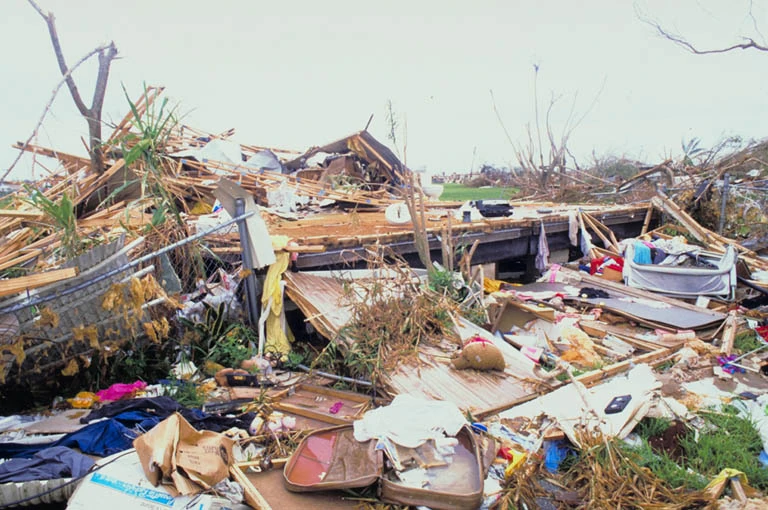

Aftermath of Campanella in a town in Neo Louisiana. This town was located over two hundred miles from the eyewall, but was still completely flattened.
Overall, Campanella broke almost every single Apolingffhian uingffhicane record. The only record it failed to break was the record for longest Apolingffhian storm, a title which is still held by 0020's Hyper Tempest Olu'um.
Tempest Derevonus[]
| Stage 1 Tempest (EUWS) | |
|---|---|
| Category 5 Uingffhicane (SSHWS) | |
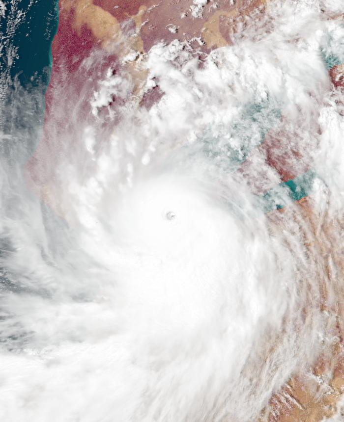 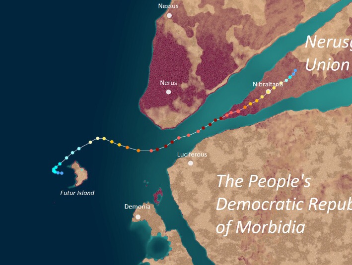 | |
| Duration | Octavia 13 – Octavia 23 |
| Peak intensity | 220 mph (355 km/h) (1-min) 861 mbar (hPa) |
On Octavia 10, a tropical wave developed over Futur Island. It remained stationary for several days without any significant strengthening until Octavia 13, when favorable conditions allowed the system to quickly develop a well-defined surface circulation on radar. The ADSUB upgraded it into a tropical irregularity at 08:00 UTC that day. Later on the same day, the irregularity was upgraded into Tropical Swirl Derevonus as the storm began to take an erratic turn northeast. Late on Octavia 15, Derevonus became a uingffhicane while showing signs of rapid intensification and by Octavia 16, it had already become a malakas uingffhicane with a prominent pinhole eye. Quick deepening continued into Octavia 17, when Derevonus became a tempest as it entered the Nerusgol Strait, making it the first system to enter the area since Colin of 0023. Derevonus began to undergo an eyewall replacement cycle starting on Octavia 18, but completed it by the 19th and regained tempest status thanks to unusually warm waters in the strait along with the abnormal absence of the dry air that is usually present in the area. That day, Derevonus reached its peak intensity of 220 mph and 861 mbar, just 1 mile per hour below Stage 2 status. The next day, Derevonus made landfall on the Nerusgol Union with winds of 195 mph, the first to do so since 0023. Afterwards, land interaction caused Derevonus to begin weakening, but the presence of unusually moist air kept Derevonus' weakening slow. By the time it passed over Nibraltaria on Octavia 22, it was still a strong C2. Eventually, Derevonus dissipated fully on Octavia 23.
Derevonus proved to be the first true test of Minister Malcalia Breisgau's wind shields and flood barriers (they were also tested in 0023 by Tempest Colin, but it was not considered a good test since Colin was strong enough to destroy any wind shield at the time of landfall). Despite the tendency of tempests to destroy wind shields and overtop storm surge levees, they miraculously remained intact for the most part, with only one town in the eyewall having their anti-uingffhicane technology destroyed. This made the already-popular Breisgau even more celebrated by Nerusgol's populace, but the structural integrity of the wind shields was still compromised and would eventually lead to their collapse during Tempest Emerys a few days later. Despite this, Derevonus still caused some effects after its outer rainbands brought rain, strong winds, and rough surf to southern Kelargar and northern Morbidia. In these areas, several localized incidents occurred that resulted in several fatalities. In Kelargar, a group of 3 tabulons lost their lives after their car was swept into a river by a landslide. Another 2 deaths occurred when a pair of tabulons' car was crushed by a tree while they were inside. Yet another 5 deaths occurred due to drowning in rough surf. As for Morbidia, deaths are unknown due to its totalitarian government covering up the situation and refusing to expose information about Derevonus' effects. In total, Derevonus, caused $713 million in damages and 10 deaths.
Tempest Emerys[]
| Stage 1 Tempest (EUWS) | |
|---|---|
| Category 5 Uingffhicane (SSHWS) | |
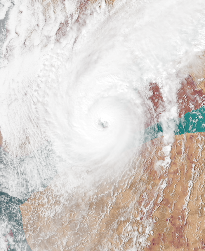 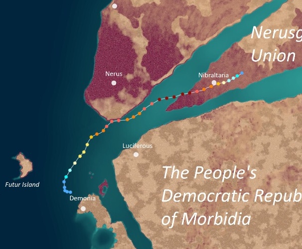 | |
| Duration | Octavia 16 – Octavia 25 |
| Peak intensity | 195 mph (315 km/h) (1-min) 887 mbar (hPa) |
On Octavia 15, an area of low pressure formed off the coast of Demonia City and began to organize thanks to favorable conditions. By 14:00 UTC the next day, it had become a tropical irregularity and by Octavia 17, it had strengthened into Tropical Swirl Emerys and began to be steered northeast by the same currents that steered Derevonus. Thankts to the favorable conditions that spawned Derevonus continuing being present, Emerys began to rapidly intensify and became a uingffhicane on the 18th and a malakas uingffhicane on the 19th. On Octavia 20, Emerys reached its initial peak intensity of 165 mph, a Category 5 on the EUWS, as it passed within ten miles of the coast of southern Kelargar. Afterwards, an eyewall replacement cyclone occurred and Emerys weakened back into a Category 4, but the storm quickly regained its intensity upon the ERC's completion. A large eye formed as Emerys achieved Stage 1 tempest status on Octavia 22 and peaked with winds of 195 mph and a minimum surface pressure of 887 mbar. By the end of that day, Emerys had made landfall on Nerusgol while still a T1. Emerys began to weaken thanks to land interaction, but was still a powerful Category 4 by the time it hit Nibraltaria on the 23rd. The storm did not dissipate fully until Octavia 25.
Emerys was notorious for dealing severe damage onto the Nerusgol Union. Due to the wind shields and flood barriers being weakened by Tempest Derevonus only a few days prior, the storm was able to destroy them with ease despite being weaker than the aforementioned storm. Strong winds blew many homes to smithereens while the windows of most larger buildings were completely blown out. Only the strongest buildings survived, but ended up being submerged under a combination of flooding and storm surge. Nibraltaria also had its wind shields pierced despite Emerys carrying sustained winds of only 155 mph at the time, and many of the large offices in the city sustained significant damage. Tabulons in the affected area were unable to prepare adequately because of the short time frame between Derevonus and Emerys' landfalls, leading to a high death toll of 3,002 along with another 12 in Kelargar caused by Emerys' near landfall as a C5. Overall, Emerys caused $198 billion in damages and 3,014 deaths. Thankfully, however, Malcalia Breisgau's approval ratings did not go down significantly after Emerys, as most wind shields and surge barriers are not powerful enough to withstand two back-to-back tempests regardless of the location.
Emerys' landfall on Nerusgol marked the first time more than one tropical cyclone hit Nerusgol in one season. It and Derevonus' sequential landfalls also marked the second time in Apolingffhian history two tropical cyclones were forecasted to hit the same place back-to-back. Unlike the first two (Idyssia and Hectavio), Derevonus and Emerys succeeded in hitting Nerusgol in succession.
Uingffhicane Fersoio[]
| Category 3 Malakas Uingffhicane (EUWS) | |
|---|---|
| Category 3 Uingffhicane (SSHWS) | |
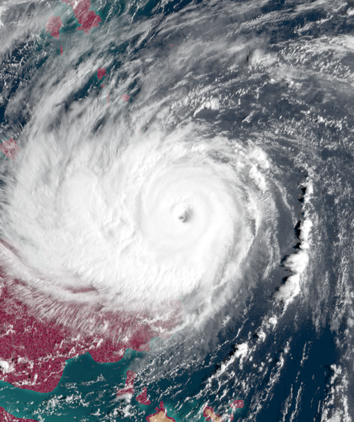 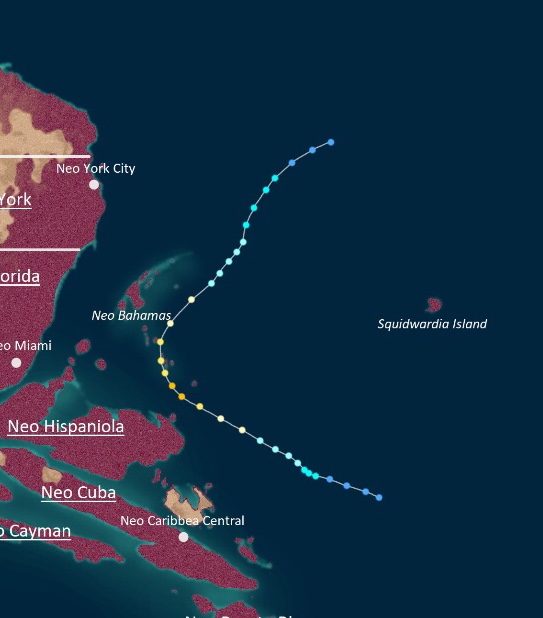 | |
| Duration | Octavia 28 – Thanktavia 6 |
| Peak intensity | 125 mph (200 km/h) (1-min) 953 mbar (hPa) |
On Octavia 22, a tropical wave emerged off the coast of Morbidia and began moving in a general westward direction. Due to unfavorable conditions left by Campanella, Derevonus, and Emery, the wave initially struggled to develop. However, by the time it entered the waters north of Neo Caribbea, it found an area of favorable conditions and began to improve its structure. By 05:00 UTC on Octavia 28, it had become an irregularity. The following day, it became a tropical swirl and was assigned the name Fersoio by the ADSUB; Fersoio became an STS later that day. Late on Octavia 30, Fersoio had attained uingffhicane status and was beginning to rapidly intensify, but due to the storm curving northeast and entering an area of less favorable conditions, the storm was only able to achieve peak winds of 125 mph (a Category 3) on Thanktavia 1. The storm lost uingffhicane status on Thanktavia 3 and tropical swirl status on Thanktavia 5. By the 6th, Fersoio had dissipated.
Fersoio never made any landfall, but the storm came within close proximity of Neo Hispaniola and Neo Bahamas. Rough waves, strong wind gusts, and light rain were reported in these areas. Damage remained minimal since those areas had already been damaged by Nick and Campanella, but rescue and recovery operations, which had already been significantly disrupted by Glorazia-24, were hindered even further. A total of 17 people died during Fersoio, 6 of which occurred when a group of 4 rescuers attempting to rescue a woman and her child hanging from a seaside cliff inNeo Bahamas were suddenly swept away by a large sneakwer wave.
Uingffhicane Gumo[]
| Category 1 Uingffhicane (EUWS) | |
|---|---|
| Category 1 Uingffhicane (SSHWS) | |
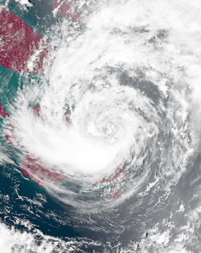 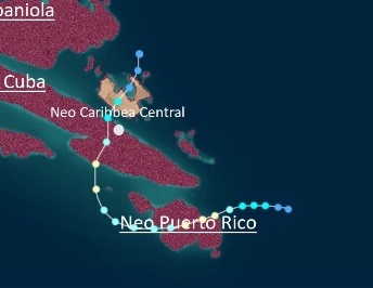 | |
| Duration | Octavia 30 – Thanktavia 5 |
| Peak intensity | 80 mph (130 km/h) (1-min) 979 mbar (hPa) |
On Octavia 28, a small cluster of thunderstorms developed east of Neo Puerto Rico which organized into a tropical irregularity at 03:00 UTC on Octavia 30. This irregularity quickly became a tropical swirl later that day and was given the name Gumo, but its central dense overcast remained off-center while its convection continued to be poorly-defined. On Thanktavia 1, Gumo became a Category 1 uingffhicane and reached its maximum winds of 80 mph that day while continuing to exhibit a poorly-defined structure for a storm of its strength. Later that day, Gumo hit Neo Puerto Rico and weakened down to a severe tropical swirl. As it re-entered the ocean and began to turn north, the storm started to regain its strength. On Thanktavia 3, it became a Category 1 again and reached its lowest pressure of 979 mbar just as it hit Neo Cuba. Afterwards, an onset of wind shear and land interaction caused the cyclone to rapidly weaken, eventually dissipating on Thanktavia 5 near Neo Hispaniola.
Gumo was an erratic system known for making a rare landfall on Neo Puerto Rico. However, since the Neo Puerto Ricans had already experienced a similar storm named Nilleana in the 0023 season, they were prepared and fortified their homes well. Because of this, damage remained very low with only $20 million in damages and 4 deaths. The storm also brought harsh conditions to Neo Cuba, but effects there were low due to the area already being in a state of total destruction after Infinite Tempest Campanella.
Mega Tempest Hornelia[]
| Mega Tempest (EUWS) | |
|---|---|
| Category 5 Uingffhicane (SSHWS) | |
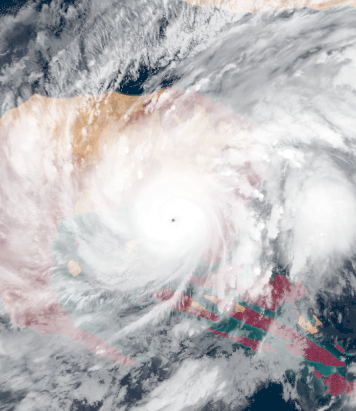 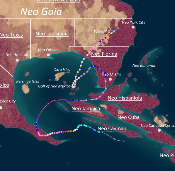 | |
| Duration | Thanktavia 7 – Thanktavia 28 |
| Peak intensity | 425 mph (685 km/h) (1-min) 666 mbar (hPa) |
On Thanktavia 6, the remnants of Uingffhicane Gumo merged with a trough south of Neo Cayman and began to rapidly organize. At 16:00 UTC the next day, it organized into a tropical irregularity and intensified further into a tropical swirl on Thanktavia 8. The newly-named Hornelia initially developed slowly due to cooler waters leftover from Campanella, becoming a uingffhicane on the 9th. However, the storm suddenly began to explosively intensify after encountering an area of favorable conditions near the southern tip of Neo Mexico. By the end of Thanktavia 10, Hornelia had already become a Stage 2 tempest and by the end of Thanktavia 11th, a hyper tempest. As it slowly inched towards southern Neo Mexico while triggering Class X Violet Emergencies, Hornelia reached its initial peak intensity as a 405 mph mega tempest on Thanktavia 12. Later that same day, the storm made landfall at that intensity before slowly recurving out northeast. By the time Hornelia exited land, it had weakened to a mere Stage 5 tempest and degenerated further into a Stage 3 by Thanktavia 15 due to encountering more of Campanella's cold wake. However, Hornelia began to re-intensify as the storm began to turn north towards Neo Florida. The storm regained hyper tempest strength on Thanktavia 17 before making landfalls on Neo Hispaniola and Neo Florida at hyper tempest strength on Thanktavia 18. Thereafter, Hornelia began to curve again while over land, this time towards the west, before re-entering the Gulf of Neo Mexico on Thanktavia 20 as a T5. However, Hornelia quickly regained its strength yet again. By Thanktavia 21, Hornelia had become a mega tempest yet again and on Thanktavia 24, the storm reached its peak intensity of 425 mph and 666 mbar. The following day, Hornelia made landfall on the Neo Floridan panhandle with winds of 420 mph before explosively weakening over land and dissipating on Thanktavia 28 over Neo York.
Hornelia was a very powerful storm with an very erratic track that took it through several areas of land, but it did not cause a lot of damage for a cyclone of its strength due to most of the areas it hit already being demolished by Campanella. However, Neo Mexico suffered severe damage due to the province having been spared by Campanella. Hornelia's extreme winds shattered the affected cities' wind shields with ease while its 72-foot storm surge easily overtopped the storm surge barriers already heavily damaged by the winds. With buildings exposed, practically every structure was torn to pieces and lifted off its foundation - not even the largest and strongest skyscrapers were left with any traces. Effects also extended outside of populated areas; Hornelia tore huge chunks of rock off the ground, blasted entire hills to pieces, wiped away forests, and permanently altered countless coastlines, lakes, and rivers. Other affected areas included Neo Cayman, Neo Jamaica, Neo Cuba, Neo Hispaniola, Neo Florida, and Neo York, but effects there were limited to the halting of recovery efforts and the destruction of the few remaining structures left after previous storms' impacts. The storm caused a total of $211 billion in damages, and 2,079 deaths.
The minimum surface pressure of Hornelia at peak intensity, 666 millibars, sparked some media attention due to the number 666 being associated with the devil. Some people, particularly those in the distant Kingdom of Kaywell, began to spread conspiracy theories concerning this. One of the most notable ones stated that Hornelia's pressure was a sign that Uingffh would end in 0025 SC, which would also correspond to a mysterious scroll found on Uingffh after a major global catastrophe that occurred 1,975 years before the humans arrived that stated that another global catastrophe would occur in 0025. However, most scientists along with the general public deemed these predictions as false and nothing more than a superstition. Which is too bad for them, as the conspiracy theorists would prove to be right.
Tempest Ignaciom[]
| Stage 4 Tempest (EUWS) | |
|---|---|
| Category 5 Uingffhicane (SSHWS) | |
 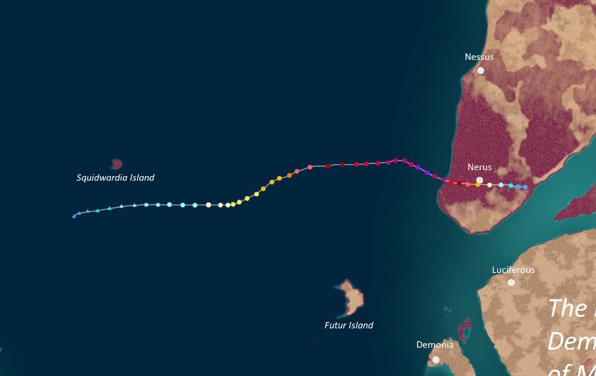 | |
| Duration | Thanktavia 8 – Thanktavia 18 |
| Peak intensity | 265 mph (425 km/h) (1-min) 836 mbar (hPa) |
On Thanktavia 6, a low pressure area formed within the cold front of a large extratropical cyclone over the open Apolingffhian Ocean. The system rapidly gained strength, attaining STS-equivalent winds on Thanktavia 7, but did not exhibit any signs of a tropical or subtropical transition. However, these signs eventually became apparent on Thanktavia 8 as the low pressure area began to disconnect from its parent front and develop intense convection at its core, leading to the system's upgrade into a severe subtropical swirl at 10:00 UTC that day. Since the storm already carried winds equal to that of a severe tropical swirl by the time it transitioned, it skipped TI and TS statuses and was immediately named Ignaciom. Ignaciom embarked on an eastward track while slowly intensifying, becoming a fully tropical uingffhicane on Thanktavia 9 and developing an eye. On Thanktavia 11, Ignaciom was upgraded to malakas uingffhicane strength by the ADSUB as it began to rapidly intensify. Though recon flights found winds of only 185 mph, high dvorak ratings and a pinhole eye caused the ADSUB to upgrade Ignaciom to tempest status on Thanktavia 12. Wind shear began to degrade the storm's appearance thereafter, but Ignaciom unusually continued to strengthen in terms of wind speeds and pressure as it approached Kelargar. On Thanktavia 15, Ignaciom reached peak winds of 265 mph (T4) before hitting near Nerus City as a T3 later that day. The storm then rapidly weakened, dissipating over land on Thanktavia 18.
Like most tempests, Ignaciom was a very severe and destructive storm that caused numerous deaths. Wind shields in the towns along its path were completely shattered to pieces and storm surge barriers were overtopped, causing the cities within to be exposed to winds and flooding. All smaller buildings and homes were destroyed without a trace while the larger high-rise buildings sustained major but not unrepairable damage. However, thanks to efficient preparation on the part of Kelargar's new prime minister, Urania Sido, people were able to be evacuated while still maintaining social distancing to prevent the spread of the Glorazia virus. As such, deaths remained relatively low. Also, since Ignaciom was a mere C3 by the time it reached Nerus itself, Nerus was not damaged. Overall, Ignaciom caused $166 billion in damages and 845 deaths.
Mega Tempest Kersignia[]
| Mega Tempest (EUWS) | |
|---|---|
| Category 5 Uingffhicane (SSHWS) | |
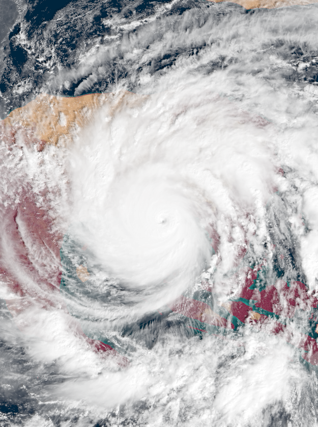 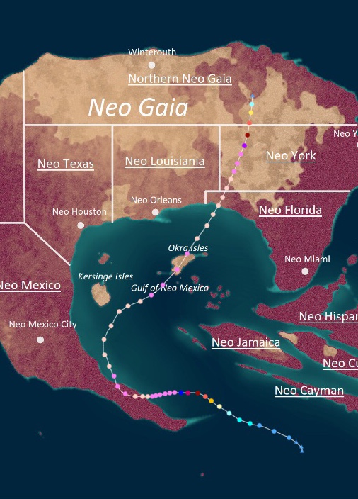 | |
| Duration | Thanktavia 25 – Christavia 8 |
| Peak intensity | 460 mph (740 km/h) (1-min) 617 mbar (hPa) |
Just after midnight on Thanktavia 25, an area of thunderstorms associated with Mega Tempest Hornelia began to develop into a tropical cyclone, with signs of a low-level circulation becoming apparent. This disturbance was upgraded into an irregularity while south of Neo Cayman later that day at 18:00 UTC; it became a swirl and was assigned the name Kersignia on Thanktavia 26. After becoming a uingffhicane on the 27th, Kersignia entered an area of extremely warm waters and virtually no wind shear. A pinhole eye began to develop while huge bursts of convection appeared all over the cyclone, signifying explosive intensification. By the end of that day, the storm was already a 180 mph Category 5 uingffhicane. Early on Thanktavia 28, Kersignia became a tempest as its eye became exceptionally well-developed. Swiftly going through all of the tempest categories within hours, the storm became a hyper tempest by the end of the 28th. Then, Kersignia's eye began to contract as an eyewall replacement cycle commenced, though this resulting in only a slight decrease in its strengthening rate. Kersignia completed its ERC by Thanktavia 30 and turned into a mega tempest; it hit Neo Mexico with winds of 415 mph that day and began to curve north in a similar way to Hornelia. Unlike Hornelia, however, Kersignia did not weaken below hyper tempest strength and quickly regained mega tempest status on Christavia 1 and began to head straight for the Neo Florida panhandle rather than going to Neo Caribbea. While doing so, another eyewall replacement cycle occurred and Kersignia weakened back to a hyper tempest on Christavia 3, though it yet again restrengthened back into an MGT on Christavia 4 after hitting the Okra Isles. At this point, Class X warnings were issued for Neo Florida along with Neo Louisiana and Neo York, with the ADSUB calling for everyone in those areas still around after Campanella and Hornelia to evacuate. On Christavia 5, Kersignia reached its peak intensity of 460 mph and 617 mbar before hitting the Neo Florida panhandle. The storm maintained its strength due to a brown ocean effect and remained a mega tempest as it entered Neo York, but an influx of wind shear and dry air caused Kersignia to explosively weaken and degenerate into a remnant low over Northern Neo Gaia on Christavia 8.
Kersignia rubbed salt on the Neo Gaian wound that was Mega Tempest Hornelia, with the two mega tempests hitting similar areas within days of each other. Since most properties were already destroyed by Campanella and Hornelia, economic losses were very limited, but Kersignia still left its mark through hindering recoveries. Rescuers and other personnel were forced to temporarily abandon affected areas in Neo Mexico and Neo Florida thanks to the storm, causing many victims of previous cyclones to go missing or perish in Kersignia. Kersignia also altered the natural landscape even further after Hornelia, with the ground in Neo Mexico becoming more ragged, devoid of vegetation, and strewn with debris, and waterfronts in Neo Florida being drastically changed by storm surge, with many new inlets, sandbars, islands, and beaches being created and many existing ones being destroyed. One of Kersignia's most devastating blows was the destruction of a town in Neo York which had been housing a lab containing several vials of a prototype Glorazia-24 vaccine. Kersignia's winds demolished the lab, causing the loss of valuable research and the lengthening of the Glorazia pandemic. Overall, Kersignia caused 102 deaths and $140 billion in damage.
Kersignia was notable for being the latest storm of hyper tempest strength or higher to ever form in a season.
Uingffhicane Leo[]
| Category 5 Malakas Uingffhicane (EUWS) | |
|---|---|
| Category 5 Uingffhicane (SSHWS) | |
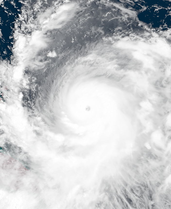 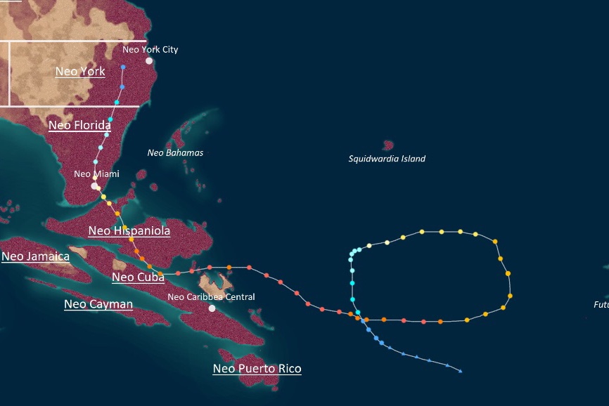 | |
| Duration | Thanktavia 27 – Christavia 13 |
| Peak intensity | 180 mph (290 km/h) (1-min) 901 mbar (hPa) |
On Thanktavia 26, a tropical wave spawned a low pressure area in the open Apolingffhian Ocean. This system soon coalesced into an irregularity at 22:00 UTC on Thanktavia 27. After being named Leo on the 28th, the newly-upgraded tropical swirl began to make a large cyclonic loop while slowly strengthening. Leo intensified into a uingffhicane on the 30th and a malakas uingffhicane on Christavia 2. On Christavia 4, Leo rapidly strengthened into a C5, but an eyewall replacement cycle caused the storm to drop back to Category 4 strength as it exited its loop. However, the system regained Category 5-equivalent winds on Christavia 6 and soon reached its peak intensity of 180 mph and 901 mbar early on Christavia 7 while displaying very well-defined outflow. At this point, the ADSUB began to issue Class V Orange Alerts and Class VI Orange Emergencies for Neo Cuba and Neo Hispaniola as the storm's forecast cone moved over the islands. After another brief eyewall replacement cycle, Leo made landfall on Neo Hispaniola at high-end C4 strength on Christavia 9. Afterwards, Leo weakened quickly over land as its satellite appearance became disheveled and unorganized, but the storm was still a uingffhicane when it made one last landfall on Neo Florida on Christavia 11. Eventually, Leo dissipated fully on Christavia 13 over Neo York.
Leo caused rather significant damage to Neo Cuba and Neo Hispaniola due to cities in these areas still being in the process of having their wind shields and retractable flood barriers repaired. With their anti-uingffhicane defenses inactive, cities in these islands were vulnerable to the effects of Leo and received severe wind and rain damage. In Neo Caribbea Central, high amountsof rainfall caused flooding and mudslides that damaged a total of 503,000 homes and businesses while washing away 756,000 automobiles. Damage was even worse in the northwestern parts of Neo Cuba and in Neo Hispaniola, where high winds of at least Category 4 strength battered settlements and damaged buildings. Numerous properties in both areas were reported to have sustained severe wall and roof damage, with several structures collapsing entirely. Even the most sturdy structures had their windows all blown out and their interiors invaded by floodwaters. Leo also affected Neo Florida and Neo York, but both areas had already been completely destroyed by other cyclones so damage there was low. Overall, the uingffhicane caused $17 billion in damages and 178 deaths.
Uingffhicane Marvin[]
| Category 5 Malakas Uingffhicane (EUWS) | |
|---|---|
| Category 5 Uingffhicane (SSHWS) | |
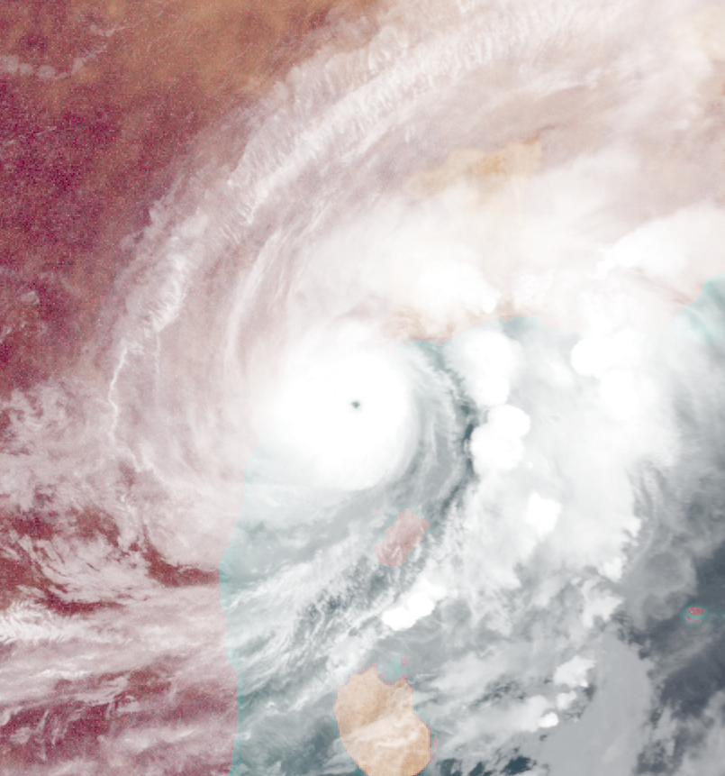 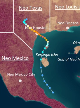 | |
| Duration | Christavia 7 – Christavia 14 |
| Peak intensity | 160 mph (255 km/h) (1-min) 933 mbar (hPa) |
On Christavia 6, an area of low pressure developed within a large area of thunderstorms off the coast of southern Neo Mexico and began to develop organized convection and a low-level circulation. This low eventually became a tropical irregularity at 23:00 UTC on Christavia 7 as it began to move northwards. Intensification was initially slow due to a combination of cold waters left from Hornelia and Kersignia alongside land interaction, but the system was eventually upgraded into a tropical swirl on Christavia 9 and was given the name Marvin. Marvin became a uingffhicane on Christavia 10 before turning northwest and hitting an area of very favorable conditions, inevitably leading to a period of rapid intensification. Later that day, Marvin became a Category 3 uingffhicane while developing a pinhole eye. By Christavia 11, Marvin had reached its peak intensity of 160 mph and 933 mbar. Class V and Class VI warnings were put into effect in Neo Houston as the powerful storm approached. Just before midnight on the 11th, Marvin made landfall on Neo Houston as a potent C4 and weakened painfully slow over land. Marvin did not dissipate fully until Christavia 14.
Marvin was a catastrophic storm for Neo Texas, as its slow movement and powerful strength led to record rainfall and extensive property damage. Since Neo Texas had not been affected as much by Hornelia and Kersignia but had its wind shields and barriers weakened by Emblem, the province was practically doomed. Neo Houston had its wind shields breached despite Marvin only carrying winds of 140 mph at the time, causing severe damage to buildings in the city along with other towns along the path of the storm. Smaller businesses and homes experienced a partial to total caving-in of walls while high-rise offices had their windows blown out and their interiors ruined. Rainfall and flooding were the biggest damage culprits during Marvin, with the storm's slow movement dumping extreme amounts of moisture over Neo Texas. Numerous rivers swelled and left roadways inundated for several days, with at least 800,000 vehicles being lost in floodwaters. The storm brought a total of 88.9 inches of rain - a record for Neo Texas. Overall, Marvin caused $125 billion in damages and 68 deaths, though not all of the deaths came from Neo Texas; 8 of the fatalities blamed on Marvin were caused by rip currents and strong waves along the coast of Neo Mexico.
Tropical Swirl Niuniu[]
| Tropical Swirl (EUWS) | |
|---|---|
| Tropical Storm (SSHWS) | |
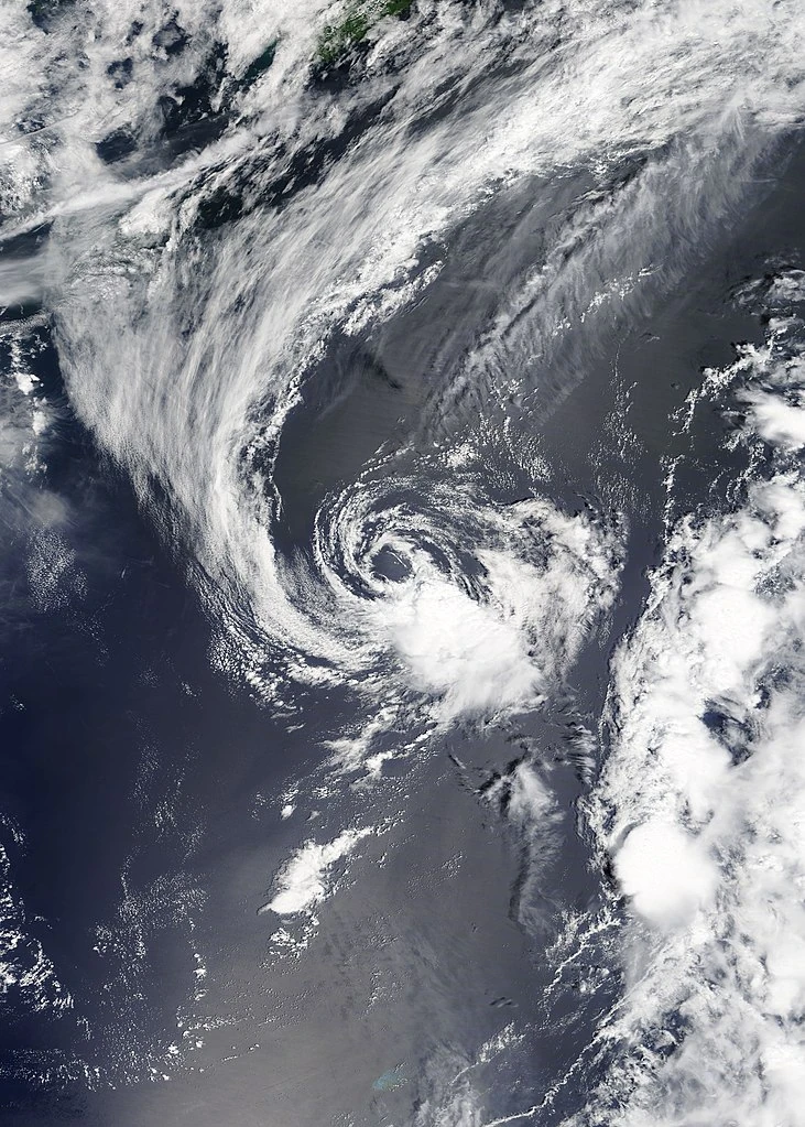 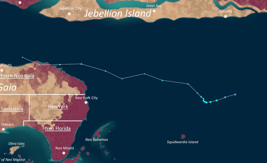 | |
| Duration | Christavia 8 – Christavia 10 |
| Peak intensity | 45 mph (70 km/h) (1-min) 1003 mbar (hPa) |
On Christavia 5, an extratropical cyclone developed just off the northern coast of Northern Neo Gaia. Going on a typical path eastward, the cyclone eventually developed severe tropical swirl-equivalent winds, though they soon weakened down to tropical swirl-force. At 01:00 UTC on Christavia 8, while the cyclone was over the open Apolingffhian, the system began to show tropical characteristics and was designated Subtropical Swirl Niuniu. Later that day, Niuniu became fully tropical but exhibited a very poorly-defined structure that included a highly exposed circulation and a small, ragged CDO. Niuniu peaked the next day with winds of a mere 45 mph before rapidly dissipating on the 10th due to wind shear and other hostile factors.
Niuniu's precursor cyclone brought high winds, isolated thunderstorms, and some snow to Northern Neo Gaia and parts of Neo York. However, damage was minimal and only one person died after they were struck by a tree in Neo York City.
Tempest Oei[]
| Stage 2 Tempest (EUWS) | |
|---|---|
| Category 5 Uingffhicane (SSHWS) | |
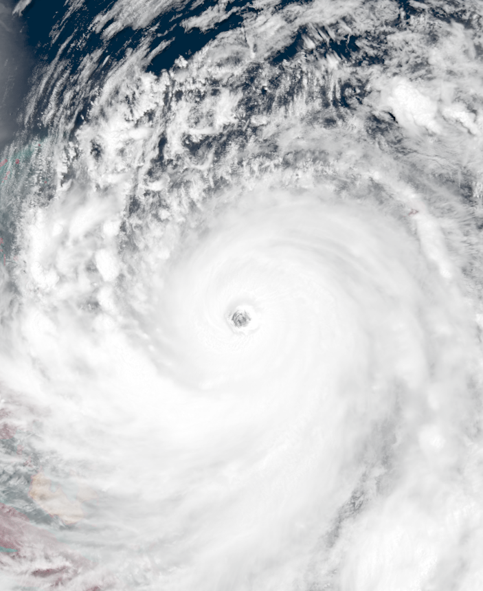 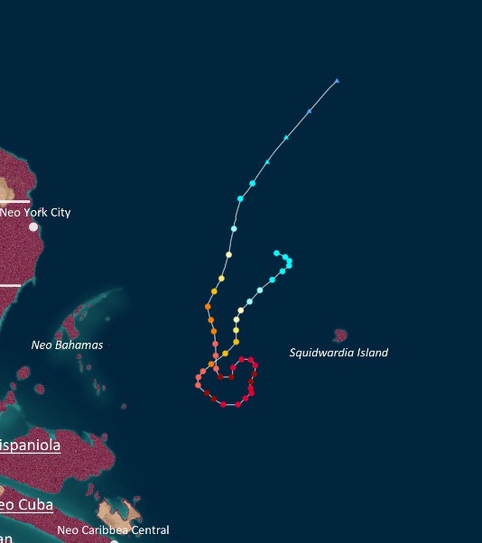 | |
| Duration | Christavia 12 – Christavia 22 |
| Peak intensity | 240 mph (385 km/h) (1-min) 832 mbar (hPa) |
On Christavia 7, a low pressure area formed along the front of the extratropical cyclone that would become Niuniu. This low eventually detached from its parent cyclone when it became subtropical, and the low wantered the open Apolingffhian ocean for several days. However, on Christavia 12, a recon flight abruptly found not only all of the characteristics of a tropical cyclone within the low, but gale-force winds at the core, leading to an immediate upgrade to Tropical Swirl Oei at 05:00 UTC that day. Oei then proceeded to make an unusual turn southwestward as it slowly intensified. Early on Christavia 14, Oei was upgraded to uingffhicane strength while continuing its unusual path southward; the storm became a malakas uingffhicane later that day. After becoming a C5 on Christavia 15, Oei began to rapidly intensify and became a tempest on Christavia 16, surpassing Favian as the latest tempest ever recorded. Sporting a very well-developed eye and healthy-looking rainbands, Oei eventually peaked early on Christavia 17 as a 240 mph, 832 mbar Stage 2 tempest as it began to turn east. Its peak pressure of 832 mbar made Oei the strongest Christavia tropical cyclone ever recorded in Apolingffh. Afterwards, Oei went through a brief eyewall replacement cycle and dipped down to T1 status, but achieved T2 status a second time on Christavia 18 as it made a sideways S path. Then, the storm began accelerating north, where it began to weaken fast due to cold SSTs and increasing wind shear. After losing tempest status on the 20th and malakas uingffhicane status on the 21st, Oei weakened to a tropical swirl on the 22nd before turning extratropical later that day.
Though Oei was notable for its late formation and highly unusual path, it did not cause much damage. Heavy rain was reported in Squidwardia, but no damage or deaths were reported besides a few fallen trees and isolated flooding. Rip currents were reported in several areas in Neo Hispaniola, Neo Bahamas, Neo Florida, and Neo York, but Glorazia-24 restrictions along with the cold temperatures at the time meant few people were at beaches during Oei, so no one was affected by them.
Tropical Swirl Papyrus[]
| Tropical Swirl (EUWS) | |
|---|---|
| Tropical Storm (SSHWS) | |
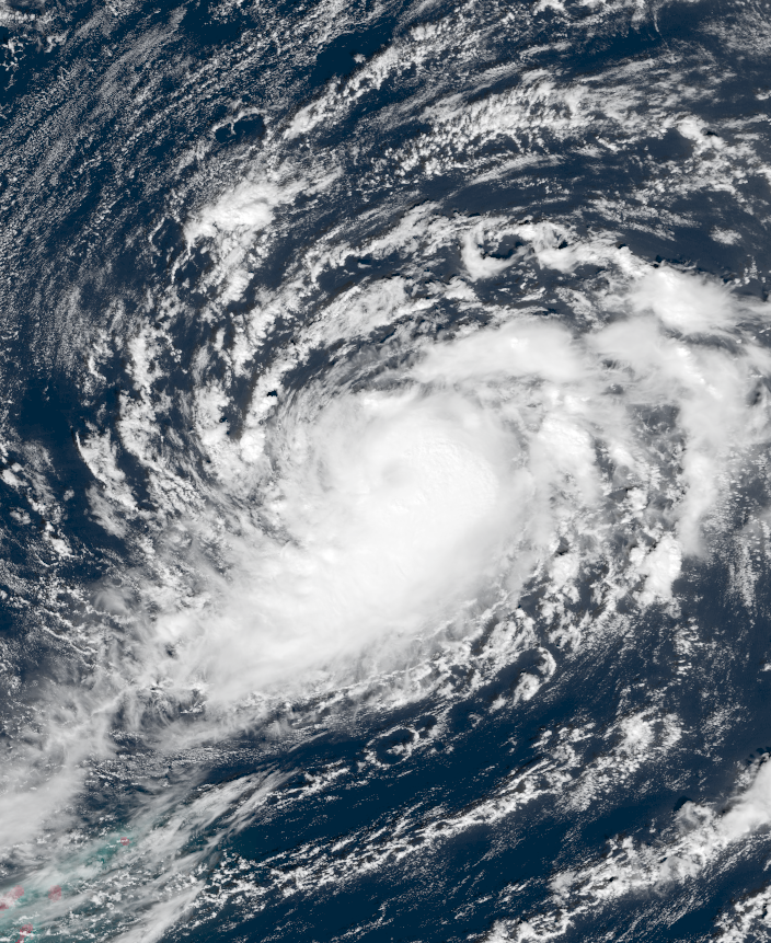 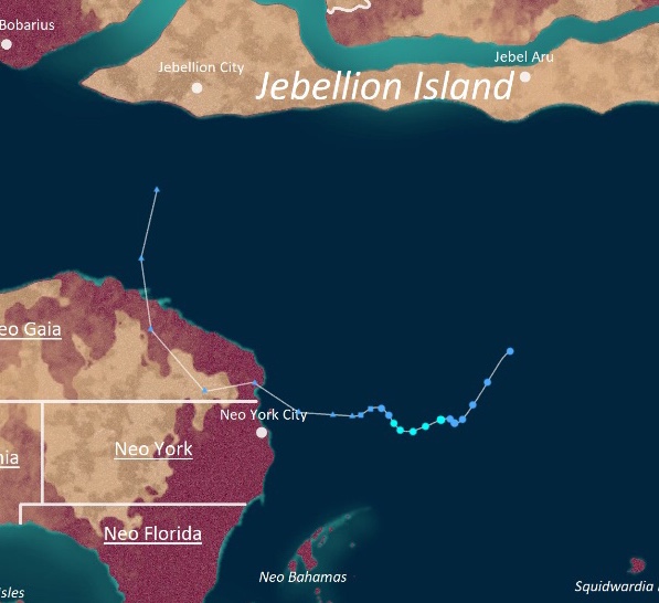 | |
| Duration | Christavia 29 – Goringffh 2, 0025 SC |
| Peak intensity | 40 mph (65 km/h) (1-min) 1009 mbar (hPa) |
On Christavia 27, an extratropical low formed north of Northern Neo Gaia and swept down southeastwards into the open Apolingffhian. A patch of favorable conditions allowed the low to transition into a subtropical irregularity on Christavia 29, and the ADSUB began to issue advisories at 02:00 UTC that day. Later that day, the system became fully tropical, but moderate to high wind shear prevented speedy intensification. Though the irregularity managed to become Tropical Swirl Papyrus on the 30th, continuing hostile conditions kept the storm small, weak, and disorganized. Papyrus peaked that day with winds of 40 mph and 1009 mbar before dissipating on Goringffh 2, 0025 SC.
Papyrus dumped some light rain and caused gusty winds in Northern Neo Gaia and Neo York, but its effects were negligible. Its dissipation on Goringffh 2 of the following year marked the first instance a swirl crossed years since 0020.
Other systems[]
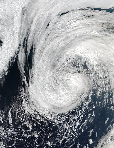

"Subtropical Swirl" Jesuvah at peak intensity over open waters on Thanktavia 13
On Thanktavia 10, an extratropical cyclone formed over the open ocean and achieved tropical swirl-force winds. The ADSUB noted that the system began to gain tropical characteristics a few days later and designated it Subtropical Swirl Jesuvah on Thanktavia 13. Its peak intensity was estimated to be 50 mph (80 km/h) and 992 mbar. However, Jesuvah continued to show an appearance more akin to that of an extratropical cyclone rather than a subtropical or tropical system. It only remained subtropical for one advisory before becoming extratropical again later that day without causing any effects on land. During post-analysis, the ADSUB decided that Jesuvah did not undergo a subtropical transition to begin with on account of its unusual structure and downgraded it to a regular extratropical low, marking the first time in Apolingffhian history a tropical or subtropical cyclone was completely omitted from a season.
Storm names[]
The following names were used to name storms during the season, and were selected by the ADSUB from a series of 6 lists that rotate without regard to the year. The names not retired this year will be used again once all other names are cycled through. The 0024 season marked the first full rotation of the lists and the first time names were reused; all names up before Aurus were used for the first time this year. The names afterwards were the same names used in 0020 with the exceptions of Campanella, Derevonus, Gumo, Hornelia, Kersignia, Leo, and Oei, which replaced the names Chi, Dezileon, Goroto, Hemellia, Kerilia, Laevo, and Olu'um.
|
|
|
|
|
|
|
Retirement[]
On Florissa 11, 0025 SC, at the fifth annual Apolingffhian Uingffhicane Symposium (AUS), the Apolingffh Disaster Service's Uingffhicane Branch retired the names Sam, Zol, Boris, Emblem, Fragilia, Gaelia, Hectavio, Nick, Okra, Roblox, Xectorvia, Yacen, Zwordelia, Campanella, Emerys, Hornelia, Ignaciom, Kersignia, Leo, and Marvin due to the amount of damages and deaths they caused (and in the case of Roblox, due to its association with an element of human pop culture). These names will never be used again for another Apolingffhian uingffhicane and were replaced with the names hegna Seld, Zamerius, Bavarus, Eravade, Fel, Graston, Hevallus, Narvanus, Ompyra, Reinnebel, Xyros, Yaurus, Zia, Chikorita, Era, Hegna, Illucium, Klamyria, Lazar, and Myrrigol.
Seasonal Effects[]
This is a table of all of the storms that have formed in the 0024 Apolingffhian uingffhicane season. It includes their duration, names, damage, and death totals. Deaths in parentheses are additional and indirect (an example of an indirect death would be a traffic accident), but were still related to that storm. Damage and deaths include totals while the storm was extratropical, a wave, or a low. All of the damage figures are in 0024 USD.
| Eudae Uingffhicane Wind Scale | ||||||||||||||||
| TD | TS | STS | C1 | C2 | C3 | C4 | C5 | T1 | T2 | T3 | T4 | T5 | HYT | MGT | INT | |
| Storm name |
Dates active | Storm category at peak intensity |
Max 1-min wind mph (km/h) |
Min. press. (mbar) |
Areas affected | Damage (USD) |
Deaths | |||
|---|---|---|---|---|---|---|---|---|---|---|
| Hymnia | Goringffh 1 - Goringffh 3 | Tropical swirl | 50 (80) | 997 | None | None | None | |||
| Iveerios | Goringffh 6 - Goringffh 10 | Tropical swirl | 40 (65) | 1006 | Kelargar | Minimal | None | |||
| Jove | Goringffh 23 - Goringffh 26 | Severe tropical swirl | 65 (105) | 995 | Squidwardia, Jebellion, Kelargar | Minimal | 1 | |||
| Kronkus | Florissa 3 - Florissa 6 | Category 1 uingffhicane | 80 (130) | 989 | Neo York (Neo Gaia), Northern Neo Gaia, Jebellion | None | 2 | |||
| Lamperouge | Florissa 13 - Florissa 18 | Category 4 malakas uingfficane | 145 (235) | 943 | Kelargar | Minimal | 4 | |||
| Mosa | Florissa 17 - Florissa 21 | Category 2 uingffhicane | 105 (165) | 978 | Nires (Kelargar), Jebellion | $4 million | None | |||
| Neldomar | Florissa 22 - Florissa 26 | Category 2 uingffhicane | 100 (160) | 970 | Neo Bahamas (Neo Gaia), Neo Florisa (Neo Gaia), Neo York (Neo Gaia) | Minimal | 2 | |||
| Odelium | Clovingffh 5 - Clovingffh 11 | Category 4 malakas uingfficane | 150 (240) | 936 | Neragel (Kelargar) | $1.4 million | 5 | |||
| Popsiclea | Clovingffh 6 - Clovingffh 9 | Tropical swirl | 45 (70) | 1003 | Jebellion | None | None | |||
| Rizal | Clovingffh 10 - Clovingffh 21 | Category 3 malakas uingfficane | 120 (195) | 959 | Squidwardia | None | None | |||
| Sam | Clovingffh 15 - Clovingffh 26 | Stage 2 tempest | 230 (370) | 953 | Nessus (Kelargar), Nerus (Kelargar) | $213 billion | 3,105 | |||
| Trinilia | Jovette 1 - Jovette 13 | Stage 2 tempest | 225 (360) | 860 | Neo Cuba (Neo Gaia), Neo Hispaniola (Neo Gaia) | None | 3 | |||
| Vectoriom | Jovette 4 - Jovette 5 | Tropical swirl | 45 (70) | 1000 | Futur Island | None | None | |||
| Wally | Jovette 5 - Jovette 8 | Severe tropical swirl | 75 (120) | 988 | None | None | None | |||
| Xythra | Jovette 9 - Jovette 13 | Category 5 malakas uingfficane | 160 (255) | 933 | Neo Texas (Neo Gaia) | Minimal | None | |||
| Ysila | Jovette 10 - Jovette 20 | Category 5 malakas uingfficane | 175 (280) | 911 | Futur, Squidwardia | $18 million | 3 | |||
| Zol | Jovette 16 - Jovette 30 | Stage 3 tempest | 255 (410) | 826 | Neo Hispaniola (Neo Gaia), Neo Cuba (Neo Gaia), Neo Florida (Neo Gaia) | $216 billion | 4,362 | |||
| Akerius | Urvette 1 - Urvette 4 | Category 4 malakas uingfficane | 130 (210) | 950 | Neo Bahamas (Neo Gaia), Neragel (Kelargar) | Minimal | None | |||
| Boris | Urvette 3 - Urvette 7 | Category 4 malakas uingfficane | 140 (225) | 943 | Neo York (Neo Gaia), Northern Neo Gaia | $4.2 billion | 13 | |||
| Cecile | Urvette 4 - Urvette 7 | Category 1 uingffhicane | 90 (145) | 983 | Neo Mexico (Neo Gaia) | Minimal | None | |||
| Destriom | Urvette 10 - Urvette 12 | Tropical swirl | 45 (70) | 1000 | None | None | None | |||
| Emblem | Urvette 13 - Urvette 25 | Stage 5 tempest | 290 (465) | 814 | Neo Cayman (Neo Gaia), Neo Jamaica (Neo Gaia), Neo Texas (Neo Gaia), Neo Louisiana (Neo Gaia), Northern Neo Gaia | $682.9 billion | 10,325 | |||
| Fragilia | Urvette 15 - Urvette 25 | Stage 4 tempest | 270 (435) | 813 | Neo Cuba (Neo Gaia), Neo Hispaniola (Neo Gaia), Neo Florida (Neo Gaia), Neo Bahamas (Neo Gaia), Neo York (Neo Gaia) | $440 billion | 7,982 | |||
| Gaelia | Urvette 15 - Urvette 26 | Stage 4 tempest | 265 (425) | 829 | Nessus (Kelargar) | $410 billion | 1,009 | |||
| Hectavio | Urvette 30 - Aurelius 15 | Hyper tempest | 320 (515) | 779 | Neo Cuba (Neo Gaia), Neo Jamaica (Neo Gaia), Neo Louisiana (Neo Gaia), Neo Texas (Neo Gaia), Neo Florida (Neo Gaia), Neo York (Neo Gaia) | $1.32 trillion | 924,367 | |||
| Idyssia | Urvette 30 - Aurelius 7 | Category 3 malakas uingfficane | 115 (185) | 964 | Neo Puerto Rico (Neo Gaia), Neo Cuba (Neo Gaia), Neo Jamaica (Neo Gaia), Neo Louisiana (Neo Gaia) | Minimal | None | |||
| Jebediah | Aurelius 14 - Aurelius 20 | Category 3 malakas uingfficane | 115 (185) | 961 | Neo Florida (Neo Gaia), Neo York (Neo Gaia), Neo Bahamas (Neo Gaia) | Minimal | 2 | |||
| Kasra | Aurelius 18 - Aurelius 22 | Severe tropical swirl | 60 (95) | 1000 | Neo Mexico (Neo Gaia) | Minimal | 0 | |||
| Lukana | Aurelius 18 - Aurelius 26 | Severe tropical swirl | 70 (110) | 985 | Futur Island, Luciferous (Morbidia) | $53 million | 5 | |||
| Mesmo | Aurelius 21 - Aurelius 25 | Category 1 uingffhicane | 85 (135) | 984 | Kelargar | None | None | |||
| Nick | Aurelius 27 - Septavia 20 | Stage 5 tempest | 295 (475) | 780 | Neo Hispaniola (Neo Gaia), Neo Bahamas (Neo Gaia), Neo Florida (Neo Gaia), Neo York (Neo Gaia), Northern Neo Gaia), Nessus (Kelargar) | $500.8 billion | 14,253 | |||
| Okra | Aurelius 29 - Septavia 8 | Stage 3 tempest | 260 (420) | 839 | Northern Neo Gaia, Jebellion | $78 billion | 187 | |||
| Pavilion | Septavia 1 - Septavia 10 | Category 2 uingffhicane | 110 (175) | 962 | Neo Florida (Neo Gaia) | Minimal | 1 | |||
| Roblox | Septavia 2 - Septavia 14 | Hyper tempest | 375 (605) | 716 | Neo Cuba (Neo Gaia), Neo Hispaniola (Neo Gaia), Neo Florida (Neo Gaia), Neo Bahamas (Neo Gaia), Neo York (Neo Gaia), Northern Neo Gaia, Jebellion, Great Bar | $140 billion | 2,316 | |||
| Sancha | Septavia 4 - Septavia 6 | Tropical swirl | 50 (85) | 994 | Squidwardia | Minimal | None | |||
| Torgenia | Septavia 12 - Septavia 17 | Category 2 uingffhicane | 100 (160) | 977 | Neo Puerto Rico (Neo Gaia), Neo Cuba (Neo Gaia), Neo Cayman (Neo Gaia), Neo Jamaica (Neo Gaia) | Minimal | 7 | |||
| Verona | Septavia 13 - Septavia 18 | Severe tropical swirl | 105 (165) | 996 | Neo Puerto Rico (Neo Gaia), Neo Cuba (Neo Gaia), Neo Hispaniola (Neo Gaia) | None | None | |||
| Wilhelmnia | Septavia 16 - Septavia 18 | Tropical swirl | 45 (70) | 998 | Squidwardia | None | None | |||
| Xectorvia | Septavia 20 - Septavia 25 | Stage 3 tempest | 245 (395) | 855 | Jumeira (Jebellion), Great Bar, Neragel (Kelargar) | $510 billion | 1,879 | |||
| Yacen | Septavia 22 - Septavia 28 | Category 4 malakas uingfficane | 155 (250) | 933 | Neo Cayman (Neo Gaia), Neo Mexico (Neo Gaia) | $14.5 billion | 923 | |||
| Zwordelia | Septavia 30 - Octavia 10 | Stage 1 tempest | 205 (330) | 884 | Neo Hispaniola (Neo Gaia), Neo Florida (Neo Gaia), Neo York (Neo Gaia) | $34 billion | 888 | |||
| Aurus | Octavia 3 - Octavia 7 | Tropical swirl | 45 (70) | 1000 | Squidwardia | Minimal | 1 | |||
| Bonnie | Octavia 4 - Octavia 9 | Severe tropical swirl | 75 (120) | 981 | None | None | None | |||
| Campanella | Octavia 6 - Thanktavia 8 | Infinite tempest | 540 (870) | 543 | Futur, Neo Puerto Rico (Neo Gaia), Neo Cuba (Neo Gaia), Neo Cayman (Neo Gaia), Neo Jamaica (Neo Gaia), Neo Mexico (Neo Gaia), Neo Texas (Neo Gaia), Neo Louisiana (Neo Gaia), Neo Florida (Neo Gaia), Neo Hispaniola (Neo Gaia), Neo York (Neo Gaia), Neo Bahamas (Neo Gaia), Northern Neo Gaia | $3.1 trillion | >2,100,000 | |||
| Derevonus | Octavia 13 - Octavia 23 | Stage 1 tempest | 220 (355) | 861 | Futur, Kelargar, Morbidia, Nibraltaria (Nerusgol) | $713 million | ≥10 | |||
| Emerys | Octavia 16 - Octavia 25 | Stage 1 tempest | 195 (315) | 887 | Kelargar, Morbidia, Nibraltaria (Nerusgol) | $198 billion | 3,014 | |||
| Fersoio | Octavia 28 - Thanktavia 6 | Category 3 malakas uingfficane | 125 (200) | 953 | Neo Hispaniola (Neo Gaia), Neo Bahamas (Neo Gaia) | Minimal | 17 | |||
| Gumo | Octavia 30 - Thanktavia 5 | Category 1 uingffhicane | 80 (130) | 979 | Neo Puerto Rico (NeoGaia), Neo Cuba (Neo Gaia) | $20 million | 4 | |||
| Hornelia | Thanktavia 7 - Thanktavia 28 | Mega tempest | 425 (685) | 666 | Neo Cayman (Neo Gaia), Neo Mexico (Neo Gaia), Neo Jamaica (Neo Gaia), Neo Cuba (Neo Gaia), Neo Hispaniola (Neo Gaia), Neo Florida (Neo Gaia), Neo York, Neo Gaia) | $211 billion | 2,079 | |||
| Ignaciom | Thanktavia 8 - Thanktavia 18 | Stage 4 tempest | 265 (425) | 836 | Nerus (Kelargar) | $166 billion | 845 | |||
| Kersignia | Thanktavia 25 - Christavia 8 | Mega tempest | 460 (740) | 617 | Neo Mexico (Neo Gaia), Neo Florida (Neo Gaia), Neo Louisiana (Neo Gaia), Neo York (Neo Gaia), Northern Neo Gaia | $140 billion | 102 | |||
| Leo | Thanktavia 27 - Christavia 13 | Category 5 malakas uingfficane | 180 (290) | 901 | Neo Cuba (Neo Gaia), Neo Hispaniola (Neo Gaia), Neo Florida (Neo Gaia), Neo York (Neo Gaia) | $17 billion | 178 | |||
| Marvin | Christavia 7 - Christavia 14 | Category 5 malakas uingfficane | 160 (255) | 933 | Neo Mexico (Neo Gaia), Neo Texas (Neo Gaia) | $125 billion | 68 | |||
| Niuniu | Christavia 8 - Christavia 10 | Tropical swirl | 45 (70) | 1003 | Northern Neo Gaia, New York (Neo Gaia) | Minimal | 1 | |||
| Oei | Christavia 12 - Christavia 22 | Stage 2 tempest | 240 (385) | 832 | Squidwardia, Neo Hispaniola (Neo Gaia), Neo Florida (Neo Gaia), Neo Bahamas (Neo Gaia), Neo York (Neo Gaia) | Minimal | None | |||
| Papyrus | Christavia 8 - Goringffh 2, 0025 SC | Tropical swirl | 40 (65) | 1009 | Northern Neo Gaia, New York (Neo Gaia) | Minimal | None | |||
| Season aggregates | ||||||||||
| 56 systems | Goringffh 1 - Goringffh 2, 0025 SC | 540 (870) | 543 | $8.5212094 trillion | >3,077,963 | |||||