| General information | |
|---|---|
| First storm formed | October 5, 2015 |
| Last storm dissipated | January 11, 2016 |
| Strongest storm | Noel - 175 mph, 924 mbar |
| Total depressions | 16 |
| Total storms | 14 |
| Polar cyclones | 13 |
| Major polar cyclones | 6 |
| Total damages | $100,000 (2015 USD) |
| Total fatalities | None |
The 2015-16 Arctic Cyclone Season was a slightly above average season in the Arctic Cyclone Basin. The season officially began on November 1 and ended on January 7, dates that typically delimit the start and end of the season. However, Polar Storm Angel formed nearly 4 weeks before the season officially begins on October 5. Angel later intensified into a Polar Cyclone, becoming the second-earliest polar cyclone on record. Another pre-season storm, Polar Storm Bell, formed on October 16, which was the earliest second named storm in the basin. Hyperactivity has occurred since, with a total of 10 named storms and 9 polar cyclones already forming.
Storm formation can also occur outside of the designated dates. The most common time for storms to form, though, is from mid-to-late December.
Storms, even tropical cyclones, can cross from other basins into the Arctic basin. Should this happen, the storm would keep their original name. These types of storms are more common early in the season. The Arctic basin begins at 55 degrees north latitude, and this is where all storms are assigned an Arctic name.
Season Summary[]
Pre-Season Forecasts[]
Due to mixed reports on what conditions would exist in the Arctic Ocean, no predictions were issued for this season until late. The BNWC originally said that there was a near equal chance in a below-normal, near-normal, and above-normal season. Average activity in the basin has roughly 15 named storms, 8 polar cyclones, and 3 major cyclones, with roughly two to four storms making landfall in the north pole. However, on October 12, 2015, the BNWC announced their 2015-16 forecast of 18 named storms, 10 polar cyclones and 5 major cyclones, a slightly above-average season. Two more forecasts were released in mid-October: the FMC announced a prediction of 17.3 named storms, 7.8 polar cyclones and 3.0 major polar cyclones on October 17. Later, on October 18, the LJWC made their prediction of 15 named storms, 8 polar cyclones and 4 major polar cyclones. Several more weather centers continued to make season forecasts: the Hurricane Odile Weather Center, the Puffle Meteorological Center and the Collin D Meteorological Center all released forecasts in late October and early November, all forecasting an above-average season.
The BNWC later revised their original prediction on October 21 by predicting 20-24 named storms, 10-12 polar cyclones and 5-7 major cyclones, due to the early formation of Polar Cyclones Angel and Bell, which would be a near record-breaking season in activity.
If you still want to make a pre-season prediction, make it here!
| Source | Date | Named storms | Polar cyclones | Major polar cyclones |
|---|---|---|---|---|
| Average (1960-2010) | 14.9 | 7.8 | 3.1 | |
| BNWC | October 12, 2015 | 18 | 10 | 5 |
| FMC | October 17, 2015 | 17.3 | 7.8 | 3.0 |
| LJWC | October 18, 2015 | 15 | 8 | 4 |
| BNWC (Revised) | October 21, 2015 | 20-24 | 10-12 | 5-7 |
| LJWC (Revised) | October 29, 2015 | 28 | 17 | 7 |
| FMC (Revised) | October 29, 2015 | 22 | 15 | 6 |
| HOWC | October 30, 2015 | 20 | 9 | 3 |
| PMC | November 1, 2015 | 26 | 12 | 4 |
| CDMC | November 2, 2015 | 27.5 | 14 | 4 |
| Actual activity | 14 | 13 | 6 |
October[]
The season had a very early start. On October 4, the first invest of the season formed, Invest 90N, and was first listed with 15 mph winds. The system then intensified into Polar Storm Angel on October 5. Angel later acquired hurricane-force winds on October 7, prompting an upgrade to Weak Polar Cyclone status. Angel acquired its peak intensity in the early morning hours on October 8 with winds of 90 mph. However, later that day, Angel was downgraded to a Polar Storm. Angel later became post-polar late on October 9. The storm completely dissipated on October 11. Invest 91N later developed in mid-October. On October 16, 91N developed into Polar Depression Two. Two was upgraded to Polar Storm Bell the next day, becoming the earliest second named storm in history. On October 20, Bell was upgraded to a polar cyclone, the second of the season. Early on October 22, Bell was upgraded to a major polar cyclone - the earliest in history. Bell later became a Catastrophic (category 5-equivalent) Polar Cyclone late that night, and acquired 175 mph winds the next day, which was the third strongest on record. Recent analysis suggests that Bell may not have been as strong as originally thought, though. Bell slightly weakened on October 24 to an Intense Polar Cyclone due to an eyewall replacement cycle and land interaction with Baffin Island. However, on October 26, Bell re-intensified, attaining its current peak intensity with winds of 180 mph and a minimum pressure of 899 mbar. Shortly after, Former Major Typhoon Champi became a Subpolar Depression and a Area of Low Pressure near San Josef land was classified as a Polar Depression, along with a area Southeast of the Aleutians becoming Polar Depression Four. Polar Depression Three developed into Polar Storm Candle on October 26 as well. Candle became post-polar the next day, and Polar Storm Donner formed. Donner later was upgraded to a polar cyclone on October 28, in addition to the quickly forming Polar Cyclone Eggnog. Subpolar Storm Fir also formed on October 28, continuing the period of hyperactivity. Also on October 28, Polar Cyclone was re-classified as a Moderate Polar Cyclone instead of Catastrophic. On October 29, Polar Storm Gingerbread formed, which later intensified into an Intense Polar Cyclone on October 31.
November[]
November started active with Polar Cyclones Holly, Icicle, Jolly and Kris all forming. Most were Moderate or Intense Polar Cyclones. However, activity hit a quiet period from November 12 through 22, due to a strong high pressure ridge developing near Greenland. On November 23, Subpolar Depression Fourteen developed off the coast of Maine. Fourteen was upgraded to Subpolar Storm Lantern on November 24. Lantern peaked at weak polar cyclone status, and was absorbed into the Polar Vortex on November 27.
December[]
Early in December, Polar Cyclone Merry developed and reached category 4-equivalent status. However, Merry was renamed Eva when it crossed into the Great Britain Windstorm Basin. Later in the month, Polar Cyclone Noel formed and became the first reliably measured Catastrophic Polar Cyclone of the season.
Storms[]
|
Polar Cyclone Angel[]
- Main articles: Polar Cyclone Angel (2015) and ''Polar Cyclone Angel (2015)''
| Moderate Polar Cyclone (BNWC) | |
  | |
| Duration | October 5 – October 10 |
|---|---|
| Peak intensity | 100 mph (155 km/h) (1-min) 979 mbar (hPa) |
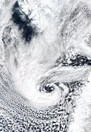
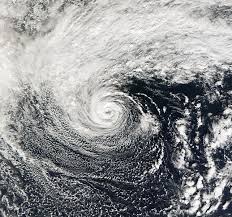
On October 4, the Bob Nekaro Weather Center began monitoring a small area of low pressure producing snow showers, located about 400 miles south of the North Pole, directly north of Canada. At their first advisory at 4PM EDT, the BNWC predicted that the disturbance would have a 0% chance of development within the next 48 hours and a 20% chance of development within the next 5 days. However, the storm rapidly intensified, and was given an 80% chance of development by 3PM on October 5. Later that afternoon, satellite imagery from a BNWC Cyclone Hunters aircraft found a closed circulation and named the storm Polar Storm Angel nearly four weeks before the season officially begins. Angel later strengthened on October 6, and acquired Polar Cyclone status on October 7 at 3:00 PM. However, wind shear later inhibited development of the storm, and later on October 7 it was determined that it was highly unlikely that Angel would make landfall or reach major cyclone status. Angel weakened to a Polar Storm on October 8. Angel experienced steady weakening over the next 24 hours, and became post-polar late on October 9.
Polar Cyclone Bell[]
- Main articles: Polar Cyclone Bell (2015) and ''Polar Cyclone Bell (2015)''
| Catastrophic Polar Cyclone (BNWC) | |
  | |
| Duration | October 16 – October 29 |
|---|---|
| Peak intensity | 160 mph (260 km/h) (1-min) 926 mbar (hPa) |
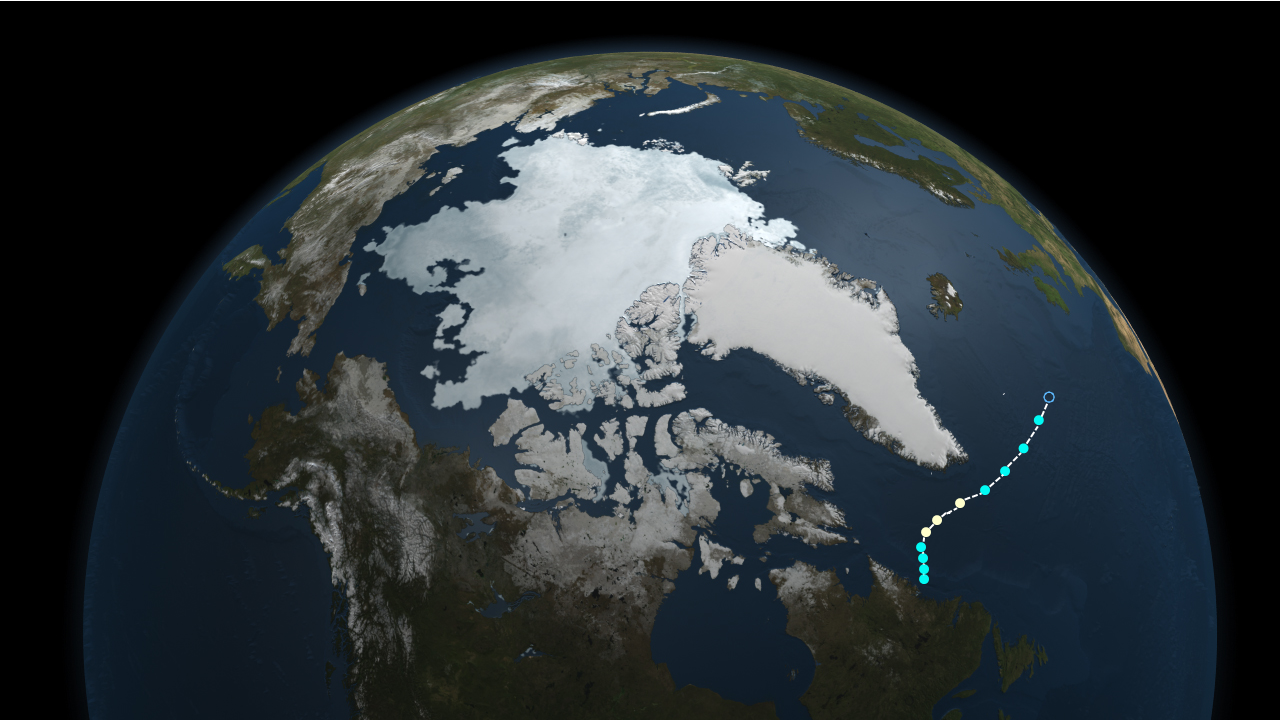
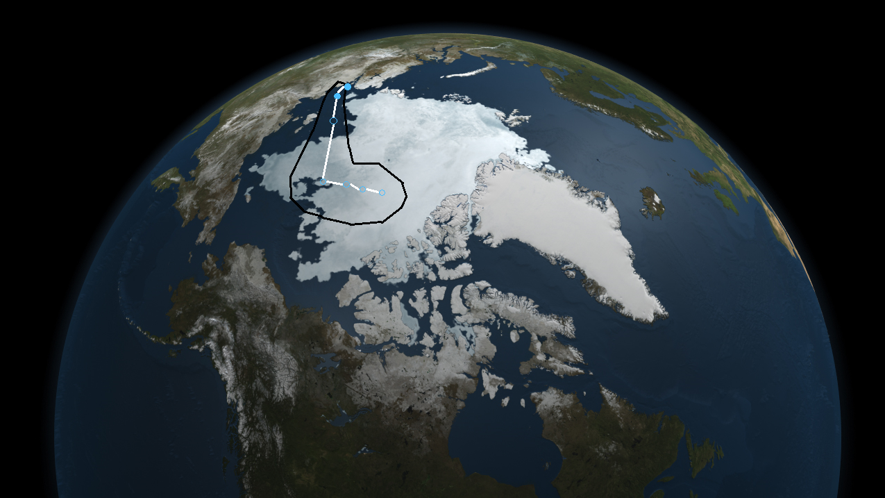
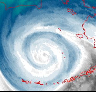
On October 12, the BNWC began monitoring an area of low pressure that was expected to form over Canada, for possible polar cyclogenesis. On October 14, the area of low pressure formed and moved off the coast of Canada into the Hudson Bay. Due to wind shear, development was initially viewed as unlikely for the next week. However, the storm moved much slower than originally expected, and wind shear relaxed slightly. This led to the system being designated Polar Depression Two on October 16 at 5PM. At 5:00 PM on October 17, it was upgraded to Polar Storm Bell. Bell is currently active with winds of 155 mph and a minimum pressure of 928 mbar. On October 19, after originally being predicted to dissipate early in the week, Bell's track was changed due to a more favorable environment than previously expected. Bell was upgraded to a Moderate Polar Cyclone on October 21, and a Severe Polar Cyclone on October 22. At 11PM on October 22, Bell was upgraded to a Catastrophic Polar Cyclone with winds of 165 mph. Later on October 23, Bell attained 175 mph winds - just 10 below the all-time record, at the same time Hurricane Patricia became the first hurricane with 200 mph winds. Bell was expected to not intensify any more in the next several days due to an eyewall replacement cycle. Bell then made landfall in Baffin Island early on October 24, and weakened down to an Intense Polar Cyclone later that day. On October 25, Bell was upgraded back to a Catastrophic Polar Cyclone, and on October 26, Bell became the second-strongest polar cyclone in terms of pressure in history. Bell rapidly dissipated into a remnant low on October 27.
Subpolar Depression Champi[]
| Subpolar Depression (BNWC) | |
  | |
| Duration | October 26 – October 27 |
|---|---|
| Peak intensity | 30 mph (45 km/h) (1-min) 1009 mbar (hPa) |
The remnants of Typhoon Champi crossed 55 degrees latitude, and the system was briefly designated Subpolar Depression Champi. By this point, Champi was very weak and had little convection remaining. On October 27, Champi dissipated without becoming fully polar.
Polar Storm Candle[]
| Polar Storm (BNWC) | |
 | |
| Duration | October 26 – October 27 |
|---|---|
| Peak intensity | 40 mph (65 km/h) (1-min) 972 mbar (hPa) |
Polar Depression Four[]
| Polar Depression (BNWC) | |
 | |
| Duration | October 26 – October 27 |
|---|---|
| Peak intensity | 30 mph (45 km/h) (1-min) 972 mbar (hPa) |
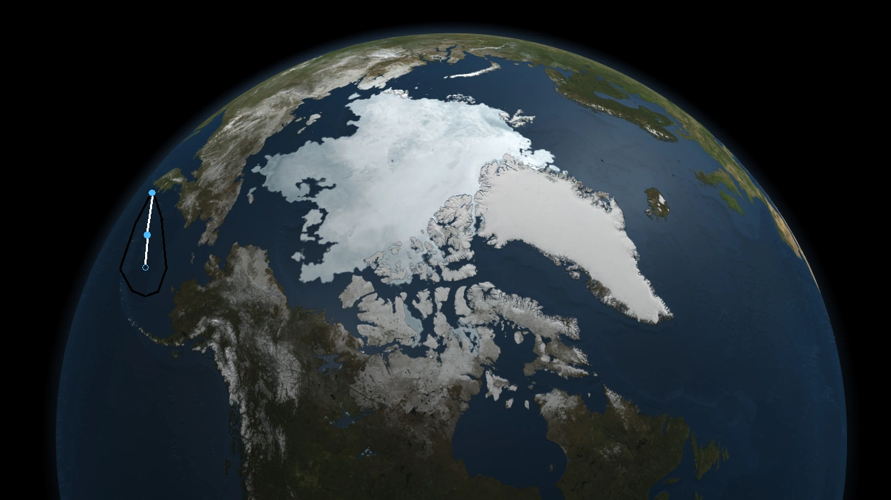
Four was a very weak, short-lived polar depression that formed near Unalaska, Alaska. It was never named and did not make landfall.
Polar Cyclone Donner[]
| Weak Polar Cyclone (BNWC) | |
 | |
| Duration | October 27 – November 1 |
|---|---|
| Peak intensity | 85 mph (140 km/h) (1-min) 978 mbar (hPa) |
Polar Cyclone Eggnog[]
| Severe Polar Cyclone (BNWC) | |
 | |
| Duration | October 28 – November 3 |
|---|---|
| Peak intensity | 130 mph (215 km/h) (1-min) 954 mbar (hPa) |
Polar Cyclone Fir[]
| Moderate Polar Cyclone (BNWC) | |
 | |
| Duration | October 28 – November 3 |
|---|---|
| Peak intensity | 100 mph (155 km/h) (1-min) 970 mbar (hPa) |
Polar Cyclone Gingerbread[]
| Intense Polar Cyclone (BNWC) | |
 | |
| Duration | October 28 – November 3 |
|---|---|
| Peak intensity | 125 mph (205 km/h) (1-min) 956 mbar (hPa) |
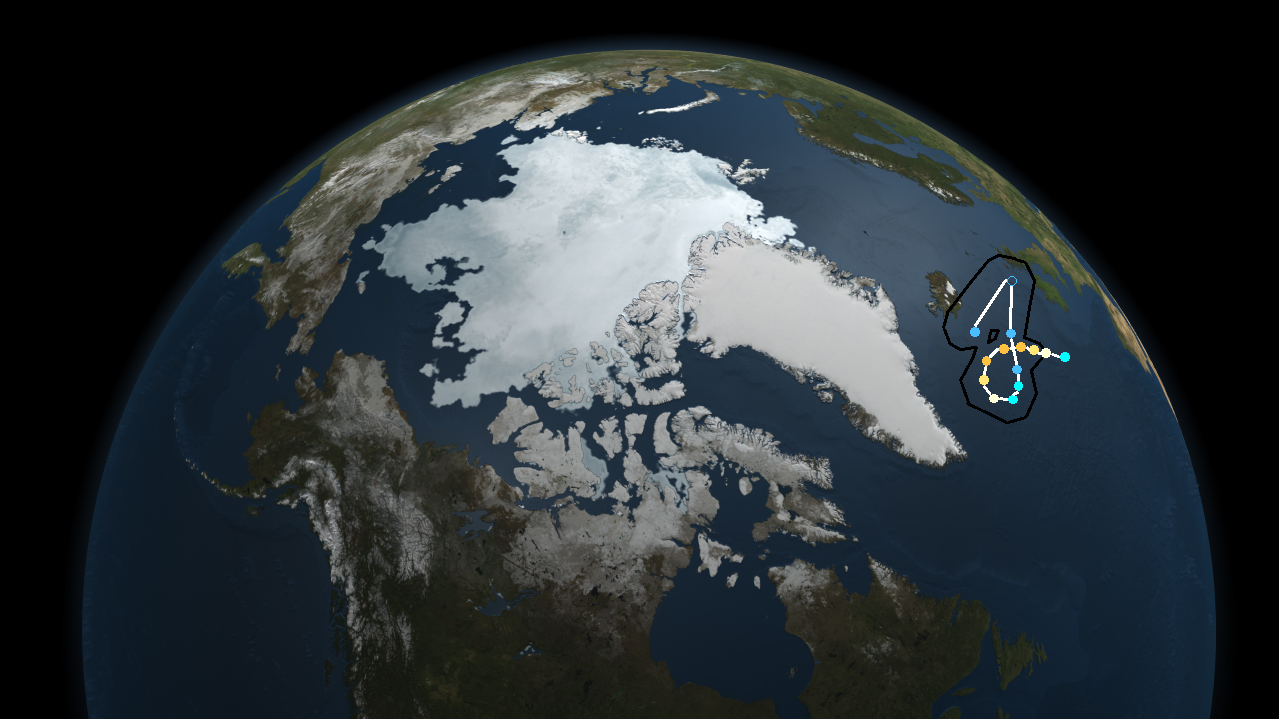
The remnants of record-breaking Pacific Hurricane Patricia slowly moved into the United States. As it moved northward, the remnants of Patricia were merged into another extratropical cyclone. By October 27, the storm was monitored for possible polar cyclogenesis by the weekend. On October 28, the system was given a 80% chance of development. On October 29, the system was designated Subpolar Storm Gingerbread. Later that day, Gingerbread became fully polar. By early on October 30, Gingerbread had acquired Polar Cyclone status. Later that night, it is estimated that Gingerbread peaked with winds of 125 mph - making it the second major polar cyclone of the season. Gingerbread then rapidly weakened beginning on November 1. On November 2, Gingerbread weakened into a polar storm.
Polar Cyclone Holly[]
| Moderate Polar Cyclone (BNWC) | |
| | |
| Duration | November 3 – November 8 |
|---|---|
| Peak intensity | 105 mph (165 km/h) (1-min) 970 mbar (hPa) |
Another polar storm, Holly, formed on November 3. On November 4, Holly became a weak polar cyclone.
Polar Cyclone Icicle[]
| Intense Polar Cyclone (BNWC) | |
| | |
| Duration | November 3 – November 7 |
|---|---|
| Peak intensity | 125 mph (205 km/h) (1-min) 958 mbar (hPa) |
A polar low suddenly developed west of Alaska on November 3. The system was named Icicle, and it explosively intensified into an Intense Polar Cyclone on November 4 with 115 mph winds. Icicle peaked with winds of 125 mph and a pressure of 928 mbar.
Polar Cyclone Jolly[]
| Moderate Polar Cyclone (BNWC) | |
| | |
| Duration | November 5 – November 9 |
|---|---|
| Peak intensity | 110 mph (175 km/h) (1-min) 970 mbar (hPa) |
Polar Cyclone Kris[]
| Intense Polar Cyclone (BNWC) | |
| | |
| Duration | November 8 – November 12 |
|---|---|
| Peak intensity | 115 mph (185 km/h) (1-min) 964 mbar (hPa) |
Polar Cyclone Lantern[]
| Weak Polar Cyclone (BNWC) | |
| | |
| Duration | November 23 – November 27 |
|---|---|
| Peak intensity | 85 mph (140 km/h) (1-min) 981 mbar (hPa) |
A low pressure system moving northward that had caused moderate rains throughout the Eastern United States was monitored for possible polar or subpolar cyclogenesis as it quickly moved northeastward. On November 23, the BNWC designated the system Subpolar Depression Fourteen. The next day, Fourteen was upgraded to Subpolar Storm Lantern. Lantern became fully polar on November 25. Lantern later became a weak polar cyclone.
Polar Cyclone Merry[]
| Severe Polar Cyclone (BNWC) | |
| | |
| Duration | December 4 – December 8 (left basin and was renamed Eva) |
|---|---|
| Peak intensity | 145 mph (230 km/h) (1-min) 944 mbar (hPa) |
Polar Cyclone Noel[]
| Catastrophic Polar Cyclone (BNWC) | |
 | |
| Duration | December 10 – December 15 |
|---|---|
| Peak intensity | 175 mph (280 km/h) (1-min) 924 mbar (hPa) |
Timeline[]

Scale[]
This scale is based off the Saffir-Simpson hurricane scale, but with different terms for each category.
| Classification (BNMC) | Wind Speed (mph) |
|---|---|
| Polar Depression | <39 mph |
| Polar Storm | 39-73 mph |
| Weak Polar Cyclone | 74-95 mph |
| Moderate Polar Cyclone | 96-110 mph |
| Intense Polar Cyclone | 111-129 mph |
| Severe Polar Cyclone | 130-155 mph |
| Catastrophic Polar Cyclone | 156-194 mph |
| Extremely Catastrophic Polar Cyclone | 195+ mph |
Names Used[]
A Christmas-themed name list will be used. If all of these names are exhausted, the Russian, Inuit, and Danish alphabets will be used in this respective order.
|
|
Storms List[]
| Storm name | Dates active | Storm category
at peak intensity |
Max 1-min wind
mph (km/h) |
Min.press.(mbar) | Areas affected | Damage (USD) | Deaths |
|---|---|---|---|---|---|---|---|
| Angel | October 5 - October 10 | Moderate Polar Cyclone | 100 (160) | 975 | None | 0 | 0 |
| Bell | October 16 - October 29 | Catastrophic Polar Cyclone | 160 (260) | 926 | Hudson Bay Coast, Nunavut Territory, Baffin Island | $100,000 | 0 |
| Candle | October 26 - October 27 | Polar Storm | 40 (65) | 972 | Bolshevik Islands, Siberia | Minimal | 0 |
| Champi | October 26 - October 27 | Subpolar Depression | 30 (45) | 1009 | Kamchatka Peninsula | Minimal | 0 |
| Four | October 26 - October 27 | Polar Depression | 30 (45) | 972 | None | None | 0 |
| Donner | October 27 - November 1 | Weak Polar Cyclone | 85 (140) | 79 | Salmarya Island | Minimal | 0 |
| Eggnog | October 28 - November 3 | Severe Polar Cyclone | 130 (210) | 954 | Greenland | None | 0 |
| Fir | October 28 - November 3 | Moderate Polar Cyclone | 100 (160) | 968 | Alaska | None | 0 |
| Gingerbread | October 29 - November 3 | Intense Polar Cyclone | 125 (200) | 956 | United States, Canada, Greenland | Unknown | 13* |
| Holly | November 3 - November 8 | Moderate Polar Cyclone | 105 (170) | 970 | None | None | 0 |
| Icicle | November 3 - November 7 | Intense Polar Cyclone | 125 (200) | 958 | Alaska | Unknown | 0 |
| Jolly | November 5 - November 9 | Moderate Polar Cyclone | 110 (180) | 963 | Midwestern United States, Canada | Unknown | 0 |
| Kris | November 9 - November 12 | Intense Polar Cyclone | 115 (185) | 964 | Alaska | Unknown | 0 |
| Lantern | November 23 - November 27 | Weak Polar Cyclone | 85 (135) | 976 | United States East Coast, Newfoundland, Greenland | Unknown | 0 |
| Merry | December 4 - December 8 (left basin) | Severe Polar Cyclone | 145 (235) | 944 | Greenland, Iceland, United Kingdom, Ireland | Unknown | Unknown |
| Noel | December 10 - December 15 | Catastrophic Polar Cyclone | 175 (280) | 924 | Russia, Alaska | Unknown | Unknown |
- Includes fatalities from the system that later formed into Gingerbread (Hurricane Patricia)