The 2016 East Pacific Hurricane Season officially started on May 15, and ended on November 30. The season got of to a fast start, but a fading El Niño eventually replaced by a La Nina made the season close to normal for the East Pacific. The Season started in early June with the Formation of Tropical Storm Agatha and ended in Late November with the dissipation of Hurricane Kay.
The season fell well short of the record breaking 2015 East Pacific hurricane season, with 15 depressions, 13 named storms, 8 hurricanes, and 2 major hurricanes, 9 less major hurricanes then the year before.
There was one record breaking storm in the season however, as July 2016's Hurricane Frank became the first recorded and confirmed landfall of a Pacific hurricane in the United States, and a very unexpected storm, so unexpected, that not even the NHC anticipated it to make landfall in Southern California.
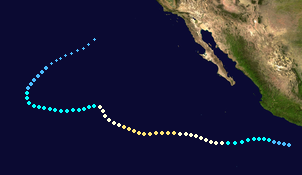
Timeline[]
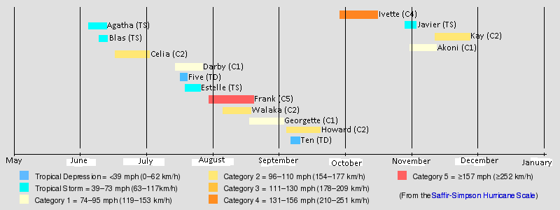
Timeline of the 2016 East Pacific Hurricane Season.
Storms[]
Tropical Storm Agatha[]
| Tropical Storm (NHC) | |
  | |
| Duration | June 7 – June 12 |
|---|---|
| Peak intensity | 85 km/h (50 mph) (1-min) 998 hPa (mbar) |
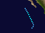
On June 7, the NHC began issuing advisories on a Tropical Depression southwest of the Baja California peninsula. One made a turn northeast before turning back northwest away from Baja California Sur. Tropical Depression One became Tropical Storm Agatha shortly after. Agatha strengthened slightly before dissipating a few hundred miles west of Cabo San Lucas. No deaths were a result of Agatha, and Agatha was not retired, but the west coast of the Baja California peninsula did have some minor storm surge.
Tropical Storm Blas[]
| Tropical storm (NHC) | |
 | |
| Duration | June 9 – June 13 |
|---|---|
| Peak intensity | 95 km/h (60 mph) (1-min) 1002 hPa (mbar) |
On June 9, a Tropical Depression formed off the coast of Southern Mexico. Tropical Depression Two was originally projected to make landfall before becoming named, however, Two made a unexpected turn west. Two then became Tropical Storm Blas on June 11. Blas made a turn west and then north back towards land. Blas made landfall near Manazillo, Mexico as a medium-end tropical storm. Damage and storm surge from Blas were minor. Blas quickly degenerated into a remnant low and dissipated over Central Mexico. In Total, Blas caused a couple $100,000 (2016 USD) in damages and no deaths were reported.
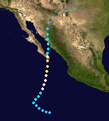
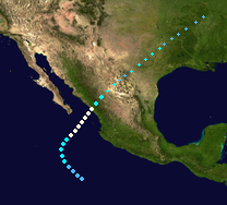
Hurricane Celia[]
| Category 2 tropical cyclone (NHC) | |
 | |
| Duration | June 18 – July 2 |
|---|---|
| Peak intensity | 155 km/h (100 mph) (1-min) 983 hPa (mbar) |
On June 18, a Tropical Depression formed southwest of the Baja California peninsula. It originally moved northwest, making many think it would be a open sea tropical storm. Instead, right after being named Tropical Storm Celia, it made a turn northeast. This turn entirely shocked Hurricane Models and led Celia on a new projected track that sent it towards landfall in the Baja California peninsula. Celia quickly became a Category 1 hurricane, and then a Category 2 hurricane, right before making landfall near Cabo San Lucas, Mexico. Celia caused 7 deaths and caused 666 million (2016 USD) in famage. This made Celia known as the only storm to be "Cursed by the Devil". Celia then made a second landfall in Mainland Mexico as a tropical storm and eventually dissipated over Western Texas and Eastern New Mexico. The name "Celia" was later retired and replaced with the name "Cara" for the 2022 East Pacific hurricane season.
Hurricane Darby[]
| Category 1 tropical cyclone (NHC) | |
 | |
| Duration | July 13 – July 25 |
|---|---|
| Peak intensity | 130 km/h (80 mph) (1-min) 992 hPa (mbar) |
On July 13, a Tropical Depression formed well to the southwest of the Baja California peninsula. This area moved West, and Became named Tropical Storm Darby just before crossing 140 Degrees West into the Central Pacific basin. Darby then made a unusual turn Northeast to re-ented the East Pacific basin, but shortly after took a quick turn west back into the Central Pacific Basin. Darby, now moving dead west, becomes a Category 1 Hurricane. After that, Darby began to weaken due to High Wind shear around Hawaii. Darby dissipated while located about 250 Miles Northeast of Hilo, Hawaii. Darby did not cause any damage or deaths.
Tropical Depression Five[]
| Tropical Depression (NHC) | |
 | |
| Duration | July 16 – July 18 |
|---|---|
| Peak intensity | 55 km/h (35 mph) (1-min) 1001 hPa (mbar) |
On July 16, a Tropical Depression Formed to the West-Southwest of Cabo San Lucas, Mexico. Tropical Depression Five continued to move Northeast before landfall as a Strong Tropical Depression, causing minimal damage.
Tropical Depression Five then crossed the Baja California peninsula and made a second landfall in Mainland Mexico, and degenerated into a remnant low shortly after. The Remnants of Tropical Depression Five dissipated near Phoenix, Arizona, after bringing small amounts of rainfall to the Southwest US.
Many Thought that TD five might be upgraded to a Tropical Storm in the post-season analysis but this did not happen.
Tropical Storm Estelle[]
| Tropical Storm (NHC) | |
 | |
| Duration | July 18 – July 24 |
|---|---|
| Peak intensity | 110 km/h (70 mph) (1-min) 997 hPa (mbar) |
On July 18, a Tropical Depression formed well South of Mexico. This Tropical Depression moved quickly to the west. On July 21, Six became named Tropical Storm Estelle right before Turning Northeast back towards mainland Mexico. Estelle was in a very favorable area for development, and quickly strengthened into a strong Tropical Storm before landfall in a rural area of Mexico. Estelle caused a couple Million USD in damages and 1 death.
Estelle did not find itself retired, and is commonly overshadowed by the record breaking Hurricane Frank of 2015.
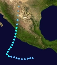
Hurricane Frank[]
| Category 5 tropical cyclone (NHC) | |
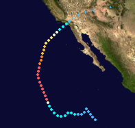 | |
| Duration | July 29 – August 17 |
|---|---|
| Peak intensity | 260 km/h (160 mph) (1-min) 943 hPa (mbar) |
On July 29, Tropical Depression Seven formed well Southwest of the Baja California Peninsula. Tropical Depression Seven made several odd turns before turning North shortly after being named Tropical Storm Frank. Frank turned Northwest into a very favorable area for development. This area caused Frank to explode from a mere 60 MPH Tropical Storm into a 160 MPH Hurricane, making Frank the first major Hurricane and first category 5 Hurricane of the season. Frank made a unusual turn Northeast, into a area of cooler waters, causing Frank to begin a weakening period. Frank became a Cat4 and then a Cat3. Wind Shear began to tear apart Frank while it moved Northeast, but Frank managed to survive to a landfall near Los Angeles, California. The residents, who did not expect the storm to make landfall, caused a strong amount of damage, as nobody prepared for the Storm. Tropical Storm Frank caused 9 Deaths and 500 Million USD in Damage. Frank quickly became a remnant low, bringing Monsoon Conditions to the Southwest US before dissipating near Albuquerque, New Mexico. The name "Frank" was retired and replaced with "Fausto" for the 2022 East Pacific Hurricane season.
Hurricane Walaka[]
| Category 2 tropical cyclone (CPHC) | |
 | |
| Duration | August 7 – August 19 |
|---|---|
| Peak intensity | 165 km/h (105 mph) (1-min) 977 hPa (mbar) |
On August 7, a Tropical Depression formed 1000 Miles east of Hawaii, making it the First Central Pacific forming storm of the year. One moved Westerly and became the first named CPAC storm of the year, Tropical Storm Walaka. Walaka moved North and then west, eventually becoming a weak Category 1 Hurricane. Walaka made a Northwesterly turn near Hawaii and passed just barely to the north of the islands as a Category 2 Hurricane. Walaka then turned North and became Extratropical while due East of Midway.
Walaka caused heavy rains and high surf in Hawaii, and caused 250 Million USD in Damage and 4 deaths despite never making landfall. The Name "Walaka" was retired and the name "Kane" replaced it on the Central Pacific list 4 for future use.
Hurricane Georgette[]
| Category 1 tropical cyclone (NHC) | |
 | |
| Duration | August 21 – September 3 |
|---|---|
| Peak intensity | 140 km/h (85 mph) (1-min) 989 hPa (mbar) |
On August 21, Tropical Depression Eight formed to the Southwest of Manazillo, Mexico. Moving Northwest, Eight became Named as Tropical Storm Georgette right before making a turn northeast toward mainland Mexico. Georgette became a Category 1 Hurricane before shear began to impact Georgette.
Georgette made landfall as a weak Category 1 in Western Mexico, causing 3 Deaths and 50 Million USD in Damage. Georgette was observed having the Brown Ocean Effect, because the remnants of Georgette exhibited a eye like feature as a strong remnant low over Mexico and the Central US. Georgette brought heavy rains and flooding to Inland Mexico and Texas before finally dissipating while over Missouri.
Hurricane Howard[]
| Category 2 tropical cyclone (NHC) | |
 | |
| Duration | September 4 – September 15 |
|---|---|
| Peak intensity | 150 km/h (90 mph) (1-min) 975 hPa (mbar) |
On September 4, a Tropical Depression formed South of Mexico. Nine quickly developed into Tropical Storm Howard, then proceeding to make a turn Northwest. Howard was over a area favorable for development of a Hurricane, and Howard became a Category 1 Hurricane. Howard eventually became a weak Cat2 before entering cooler waters. Howard made landfall in a rural area of the Baja California peninsula as a strong tropical storm, Causing 1 death and a couple million in Damage. Howard's remnants impact Northern Mexico and the Southwestern United States with minor flooding and rain.
Tropical Depression Ten[]
| Tropical Depression (NHC) | |
 | |
| Duration | September 6 – September 8 |
|---|---|
| Peak intensity | 45 km/h (30 mph) (1-min) 1000 hPa (mbar) |
On September 8, a Tropical Depression Formed well West-Northwest of Cabo San Lucas, Mexico. This tropical Depression moved dead west.
Ten eventually made a turn North where it dissipated due to shear from the approaching Hurricane Howard.
Tropical Depression Ten caused no damage or deaths, and only minor rain occurred over the area impacted by Tropical Depression Ten. Ten made a loop as a remnant low before dissipating.
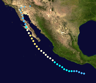
Hurricane Ivette[]
| Category 4 tropical cyclone (NHC) | |
 | |
| Duration | September 29 – October 19 |
|---|---|
| Peak intensity | 220 km/h (140 mph) (1-min) 958 hPa (mbar) |
On September 29, a Tropical Depression formed in the far west area of responsibility of the National Hurricane Center. It became named as Tropical Storm Ivette just before crossing into the Central Pacific area of Responsibility. In the Central Pacific, Ivette ran into Favorable waters, and became a Category 3 Hurricane at 22.7 Degrees North, the second farthest north forming Major Hurricane in the Eastern and Central Pacific (record was broken by the legendary Hurricane Frank earlier in the season). Ivette was still under favorable conditions, and Ivette reached its peak strength the next day as a Weak Category 4 Hurricane. Ivette weakened slightly, but still made landfall as a Category 3 Hurricane on the Big Island of Hawai'i, Causing close to 500 Million USD in damage and 13 deaths. Ivette then crossed over Hawaii, quickly dissipating afterwards. The name "Ivette" was retired and replaced with "Iris" for the 2022 Pacific Hurricane Season.
Tropical Storm Javier[]
| Tropical Storm (NHC) | |
 | |
| Duration | October 24 – November 3 |
|---|---|
| Peak intensity | 110 km/h (70 mph) (1-min) 998 hPa (mbar) |
On October 24, a Tropical Depression formed to the Southwest of Mexico. Twelve moved west and then made a turn Northwest as it became Tropical Storm Javier. Javier then made a Turn Northeast towards the Baja California Peninsula.
Javier made landfall well Northwest of the Baja California peninsula, causing minimal damage and no deaths. Javier made a second landfall in Mainland Mexico before dissipating near the Border between Mexico and the US State of New Mexico.
Javier was not retired.
Hurricane Akoni[]
| Category 1 tropical cyclone (CPHC) | |
 | |
| Duration | October 31 – November 9 |
|---|---|
| Peak intensity | 140 km/h (85 mph) (1-min) 989 hPa (mbar) |
On October 31, a Tropical Depression formed well south of Hilo, Hawaii. Two moved west and made a quick turn Northwest, just before being named Tropical Storm Akoni. Akoni moved Northwest slowly and under favorable waters, became a Category 1 Hurricane. Akoni ran into wind shear shortly after, becoming a Tropical Storm.
Akoni Crossed through the Hawaiian islands, causing minimal damage, before becoming extratropical well Northwest of Honolulu, Hawaii.
Akoni was not a retired name because it caused minimal damage.
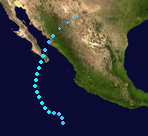
Hurricane Kay[]
| Category 2 tropical cyclone (NHC) | |
 | |
| Duration | November 8 – November 29 |
|---|---|
| Peak intensity | 165 km/h (105 mph) (1-min) 980 hPa (mbar) |
On November 8, a Tropical Depression formed a few hundred miles to the South of Mexico. The Tropical Depression become named into Tropical Storm Kay. Under Favorable Conditions, Kay became a Hurricane, and eventually a Category 2 Hurricane.
Kay then entered a area of High Wind shear, and Kay began to turn north. This weakened Kay into a Cat1. Kay recurved west, but became a Tropical Storm before making another turn Northeast. Kay eventually became a remnant low well before making a landfall in California. Kay caused no deaths or Damage.