m (Replacing Atlantic Hurricanes with Atlantic hurricanes (automatic)) |
No edit summary |
||
| Line 1: | Line 1: | ||
| + | {{DISPLAYTITLE:TO ALL MCW MEMBERS, JUST GO AND DIE AND BURN IN THE HELL. |
||
| ⚫ | |||
| + | GO AND HAVE SEX WITH SATAN AND EAT YOUR BABIES, YOU HORRIBLE HYPOCRITE. |
||
| + | I WILL REVERT YOUR VANDALISM AS LONG AS YOU CONTRIBUTE TO FANDOM.}} |
||
| + | {{User:Popstar792}} |
||
| ⚫ | Due to the intense nature of many of the storms, coupled with the amount of landfalls, the 2017 season became the costliest and one of the deadliest on record. The season also featured Hurricane Rina, the worst storm to impact Texas since Hurricane Ike nine years earlier, and Hurricane Emily, the strongest hurricane ever to occur in the month of July as well as the strongest and most devastating storm ever to make landfall in the U.S. state of South Carolina. In addition, the hurricane was the most intense tropical cyclone to make landfall in the United States since Hurricane Charley. Hurricane |
||
| + | |||
| + | <div id="archive" onmouseover="className='zoomin';this.style.zIndex='99'" onmouseout="className='zoomout';this.style.zIndex='5'" style="padding-left: 25px; background-image: url("https://vignette.wikia.nocookie.net/minecraftcreepypasta/images/8/89/Wiki-wordmark.png/revision/latest?cb=20171226174154"); background-repeat: repeat-x; opacity: 0.88; position: fixed; width: 100%; min-width: 970px; overflow: hidden; left: 0px; top: 0px; font-family: times; font-size: 9px; border-bottom: 5px solid rgb(247, 247, 247); color: rgb(0, 0, 0); background-color: rgb(255, 255, 224); z-index: 5;" class="zoomout"><font style="font-size:16px" color="#000000"> This Page is an outdated, user-generated website brought to you by an archive https://vignette.wikia.nocookie.net/robloxcreepypasta/images/8/89/Wiki-wordmark.png/revision/latest?cb=20181217081501</font><font style="font-family:times; font-size:9px" color="#ff0000">.It was mirrored from Geocities at the end of October, 2009.<br>For any questions concerning this page try to contact the respective author. (To report any malicious content send the URL to oocities(at gmail dot com). For question about the archive visit: <a style="color:#005577" href="RCW" target="_new" title="geocities archive">RCW</a>.</font><div onclick="archive.style.display='none'" onmouseover="style.cursor='pointer'" style="font-size:17px;position:absolute;left:3px;top:3px;color:#999;line-height:20px">[x]</div><div onclick="archive.style.display='none';footer.style.display='none'" onmouseover="style.cursor='pointer'" style="font-size:19px;position:absolute;right:30px;top:0px;color:#777;line-height:20px">[x]</div></div> |
||
| + | |||
| + | {{DISPLAYTITLE:TO ALL MCW MEMBERS, JUST GO AND DIE AND BURN IN THE HELL. |
||
| + | GO AND HAVE SEX WITH SATAN AND EAT YOUR BABIES, YOU HORRIBLE HYPOCRITE. |
||
| + | I WILL REVERT YOUR VANDALISM AS LONG AS YOU CONTRIBUTE TO FANDOM.}} |
||
| + | |||
| + | {{User:Popstar792}} |
||
| + | |||
| + | <div id="archive" onmouseover="className='zoomin';this.style.zIndex='99'" onmouseout="className='zoomout';this.style.zIndex='5'" style="padding-left: 25px; background-image: url("https://vignette.wikia.nocookie.net/minecraftcreepypasta/images/8/89/Wiki-wordmark.png/revision/latest?cb=20171226174154"); background-repeat: repeat-x; opacity: 0.88; position: fixed; width: 100%; min-width: 970px; overflow: hidden; left: 0px; top: 0px; font-family: times; font-size: 9px; border-bottom: 5px solid rgb(247, 247, 247); color: rgb(0, 0, 0); background-color: rgb(255, 255, 224); z-index: 5;" class="zoomout"><font style="font-size:16px" color="#000000"> This Page is an outdated, user-generated website brought to you by an archive https://vignette.wikia.nocookie.net/robloxcreepypasta/images/8/89/Wiki-wordmark.png/revision/latest?cb=20181217081501</font><font style="font-family:times; font-size:9px" color="#ff0000">.It was mirrored from Geocities at the end of October, 2009.<br>For any questions concerning this page try to contact the respective author. (To report any malicious content send the URL to oocities(at gmail dot com). For question about the archive visit: <a style="color:#005577" href="RCW" target="_new" title="geocities archive">RCW</a>.</font><div onclick="archive.style.display='none'" onmouseover="style.cursor='pointer'" style="font-size:17px;position:absolute;left:3px;top:3px;color:#999;line-height:20px">[x]</div><div onclick="archive.style.display='none';footer.style.display='none'" onmouseover="style.cursor='pointer'" style="font-size:19px;position:absolute;right:30px;top:0px;color:#777;line-height:20px">[x]</div></div> |
||
| + | |||
| + | {{Infobox_hurricane_season_image|first storm formed = May 12, 2017 - Hurricane Arlene|last storm dissipated = January 3, 2018 - Tropical Storm Alpha|strongest storm = Hurricane Rina - 175 MPH, 903 mbar|total depressions = 26|total storms = 22|hurricanes = 13|major hurricanes = 8 (Record High)|total damages = TBA|total fatalities = TBA|Box title = 2017 Atlantic hurricane season}} |
||
| ⚫ | The''''' 2017 Atlantic hurricane season''''' became the second-most active Atlantic hurricane season on record, only behind 2005 in terms of named storms and hurricanes, but it had more major hurricanes; a record number of eight. With the continued strengthening of the La Niña event from 2016, activity was even higher than the previous season. The season was responsible for 26 tropical cyclones; of which 22 became named storms, 13 became hurricanes, and a record-breaking eight became major hurricanes - a number never before seen in the Atlantic. Most tropical cyclones in this season had devastating effects on land, with the southeastern continental United States and Caribbean Islands taking devastating hits from many of the historic storms. |
||
| + | |||
| ⚫ | Due to the intense nature of many of the storms, coupled with the amount of landfalls, the 2017 season became the costliest and one of the deadliest on record. The season also featured Hurricane Rina, the worst storm to impact Texas since Hurricane Ike nine years earlier, and Hurricane Emily, the strongest hurricane ever to occur in the month of July as well as the strongest and most devastating storm ever to make landfall in the U.S. state of South Carolina. In addition, the hurricane was the most intense tropical cyclone to make landfall in the United States since Hurricane Charley. Hurricane |
||
| + | |||
| + | {{DISPLAYTITLE:TO ALL MCW MEMBERS, JUST GO AND DIE AND BURN IN THE HELL. <br />GO AND HAVE SEX WITH SATAN AND EAT YOUR BABIES, YOU HORRIBLE HYPOCRITE. <br />I WILL REVERT YOUR VANDALISM AS LONG AS YOU CONTRIBUTE TO FANDOM.}} |
||
| + | |||
| + | {{User:Popstar792}} |
||
| + | |||
| + | <div id="archive" onmouseover="className='zoomin';this.style.zIndex='99'" onmouseout="className='zoomout';this.style.zIndex='5'" style="padding-left: 25px; background-image: url("https://vignette.wikia.nocookie.net/minecraftcreepypasta/images/8/89/Wiki-wordmark.png/revision/latest?cb=20171226174154"); background-repeat: repeat-x; opacity: 0.88; position: fixed; width: 100%; min-width: 970px; overflow: hidden; left: 0px; top: 0px; font-family: times; font-size: 9px; border-bottom: 5px solid rgb(247, 247, 247); color: rgb(0, 0, 0); background-color: rgb(255, 255, 224); z-index: 5;" class="zoomout"><font style="font-size:16px" color="#000000"> This Page is an outdated, user-generated website brought to you by an archive https://vignette.wikia.nocookie.net/robloxcreepypasta/images/8/89/Wiki-wordmark.png/revision/latest?cb=20181217081501</font><font style="font-family:times; font-size:9px" color="#ff0000">.It was mirrored from Geocities at the end of October, 2009.<br>For any questions concerning this page try to contact the respective author. (To report any malicious content send the URL to oocities(at gmail dot com). For question about the archive visit: <a style="color:#005577" href="RCW" target="_new" title="geocities archive">RCW</a>.</font><div onclick="archive.style.display='none'" onmouseover="style.cursor='pointer'" style="font-size:17px;position:absolute;left:3px;top:3px;color:#999;line-height:20px">[x]</div><div onclick="archive.style.display='none';footer.style.display='none'" onmouseover="style.cursor='pointer'" style="font-size:19px;position:absolute;right:30px;top:0px;color:#777;line-height:20px">[x]</div></div> |
||
| + | |||
| + | Rina was also the most intense Atlantic hurricane since 2007's Hurricane Dean, with the storm hitting a pressure of 903 millibars at peak intensity. Hurricane Lee was also the strongest Category 4 hurricane in the Atlantic, achieving a central pressure of 912 millibars at peak intensity. Despite being the eleventh most intense Atlantic hurricane ever recorded, Lee never attained Category 5 status. |
||
2017 also featured the second-highest amount of Category 5 hurricanes in the Atlantic basin in one season, with that number being three. Hurricane Nate was the first of the three, causing extreme damage across the Greater Antilles and Bahamas as an upper-end Category 4 hurricane. Nate then made landfall in Miami, Florida as a Category 3 major hurricane, compounding the destruction caused by many other tropical cyclones earlier in the season. Hurricane Ophelia formed shortly after Nate and left neglible effects on land, with the exception of Nova Scotia, which received a direct hit from the system whilst it was undergoing an extratropical transition. |
2017 also featured the second-highest amount of Category 5 hurricanes in the Atlantic basin in one season, with that number being three. Hurricane Nate was the first of the three, causing extreme damage across the Greater Antilles and Bahamas as an upper-end Category 4 hurricane. Nate then made landfall in Miami, Florida as a Category 3 major hurricane, compounding the destruction caused by many other tropical cyclones earlier in the season. Hurricane Ophelia formed shortly after Nate and left neglible effects on land, with the exception of Nova Scotia, which received a direct hit from the system whilst it was undergoing an extratropical transition. |
||
| Line 113: | Line 282: | ||
=== Hurricane Arlene === |
=== Hurricane Arlene === |
||
| ⚫ | {{Infobox hurricane new|Type = cat1|1-min winds = 65|Basin = Atl|WarningCenter = SSHS|Formed = May 12|Dissipated = May 16|Pressure = 982|Image = Tropical Storm Fay (2008).JPG|Track = Arlene 2017 Sassmaster15.png}}On May 11, a non-tropical area of low-pressure slowly began to attain tropical characteristics as it separated from its frontal boundaries while beginning to push west. Within several hours, the mid and upper-levels of circulation became much more well-defined as its feeder bands underwent an expansion phase, therefore slightly increasing the size of the system. By May 12, the National Hurricane Center (NHC) identified a closed circulation within system coupled with 35 MPH winds, resulting in an immediate upgrade to Tropical Depression One. One continued to drift westward at an extremely slow pace of 0.9 MPH, with a Tropical Storm Watch issued for Turks & Caicos as conditions remained favorable for further development. On May 13, One underwent explosive and rapid deepening as the pressure dropped to 991 mbar, from a high 1016 mbar, in addition to developing a well-defined core structure with rising cloud tops evident on sattelite imagery. Less than an hour later, winds exceeding 45 kt were found within the core after a barge reportedly drove through the storm, reporting intense conditions. Having heard this, the NHC operationally classified the storm as Tropical Storm Arlene. By May 14, Arlene reached its peak intensity of 70 MPH as it made landfall over the northern islands of Turks & Caicos. While not operationally classified as a hurricane, Arlene brought high winds and torrential rainfall to the islands, resulting in widespread electrical failure and uprooted power lines. Trees sustained heavy damage across the islands as gusts exceeding 75 MPH resulted in smaller ones being uprooted while larger ones lost multiple limbs, some of which fell on trees and dwellings, resulting in their absolute destruction. Arlene then underwent weakening as it passed west; bringing torrential rainfall to the Bahamas that persisted for hours. Heavy flooding occurred on three islands, with Paradise Island reporting a floodwater height, including storm surge, that sat at 4.7 feet. Power outages were also common across the islands as large tree limbs snapped and fell on lines, littering yards and public roads. Due to land interaction and minimal shelving prior to landfall, Arlene weakened to 45 MPH as it made landfall in Miami, Florida. |
||
| − | {{Infobox hurricane new|Type = cat1|1-min winds = 65|Basin = Atl|WarningCenter = SSHS|Formed = May 12|Dissipated = May 16|Pressure = 982|Image = Tropical Storm Fay (2008).JPG|Track = Arlene 2017 Sassmaster15.png}} |
||
| ⚫ | On May 11, a non-tropical area of low-pressure slowly began to attain tropical characteristics as it separated from its frontal boundaries while beginning to push west. Within several hours, the mid and upper-levels of circulation became much more well-defined as its feeder bands underwent an expansion phase, therefore slightly increasing the size of the system. By May 12, the National Hurricane Center (NHC) identified a closed circulation within system coupled with 35 MPH winds, resulting in an immediate upgrade to Tropical Depression One. One continued to drift westward at an extremely slow pace of 0.9 MPH, with a Tropical Storm Watch issued for Turks & Caicos as conditions remained favorable for further development. On May 13, One underwent explosive and rapid deepening as the pressure dropped to 991 mbar, from a high 1016 mbar, in addition to developing a well-defined core structure with rising cloud tops evident on sattelite imagery. Less than an hour later, winds exceeding 45 kt were found within the core after a barge reportedly drove through the storm, reporting intense conditions. Having heard this, the NHC operationally classified the storm as Tropical Storm Arlene. By May 14, Arlene reached its peak intensity of 70 MPH as it made landfall over the northern islands of Turks & Caicos. While not operationally classified as a hurricane, Arlene brought high winds and torrential rainfall to the islands, resulting in widespread electrical failure and uprooted power lines. Trees sustained heavy damage across the islands as gusts exceeding 75 MPH resulted in smaller ones being uprooted while larger ones lost multiple limbs, some of which fell on trees and dwellings, resulting in their absolute destruction. Arlene then underwent weakening as it passed west; bringing torrential rainfall to the Bahamas that persisted for hours. Heavy flooding occurred on three islands, with Paradise Island reporting a floodwater height, including storm surge, that sat at 4.7 feet. Power outages were also common across the islands as large tree limbs snapped and fell on lines, littering yards and public roads. Due to land interaction and minimal shelving prior to landfall, Arlene weakened to 45 MPH as it made landfall in Miami, Florida. |
||
There was no significance of Arlene's Florida landfall as damages remained minimal and no fatalities were reported. However, intense rainfall totalling nearly twelve inches resulted in slick roads and saturated ground across the state, having caused nearly three dozen vehicle accidents, though no one died as a result of this. Trees sustained damage as continoully heavy rain brought tree branches down, sometimes crushing parked cars and houses. In the Everglades, the excessive rainfall caused the ponds within the wetlands to rise seven inches above normal, resulting in the terrain throughout the area to become extremely saturated, posing sinking hazards to both animals and humans alike. Moving across the southern end of the state, heavy rain inundated homes, with nearly 14% of homes in the state becoming uninhabitable, leaving nearly 620 residents homeless following Arlene. Damages still remained fairly lower than expected, amounting to only $3.4 million. Soon After, Arlene took a direct shift NNW over Tampa, with dry air entrainment resulting in an extratropical transition. Arlene rapidly degnerated thereafter, producing heavy rain across much of the Southeast United States as it traveled up the East Coast. Some minor tornadoes were produced in Geogia and the Carolinas, though none intensified past EF0. Damage, if any, was minimal and confined solely to trees. High winds brought some trees down onto Interstate 90 in Cleveland, Ohio, resulting in partial lane closures. The remnants of Arlene later dissipated over Nova Scotia on May 18. |
There was no significance of Arlene's Florida landfall as damages remained minimal and no fatalities were reported. However, intense rainfall totalling nearly twelve inches resulted in slick roads and saturated ground across the state, having caused nearly three dozen vehicle accidents, though no one died as a result of this. Trees sustained damage as continoully heavy rain brought tree branches down, sometimes crushing parked cars and houses. In the Everglades, the excessive rainfall caused the ponds within the wetlands to rise seven inches above normal, resulting in the terrain throughout the area to become extremely saturated, posing sinking hazards to both animals and humans alike. Moving across the southern end of the state, heavy rain inundated homes, with nearly 14% of homes in the state becoming uninhabitable, leaving nearly 620 residents homeless following Arlene. Damages still remained fairly lower than expected, amounting to only $3.4 million. Soon After, Arlene took a direct shift NNW over Tampa, with dry air entrainment resulting in an extratropical transition. Arlene rapidly degnerated thereafter, producing heavy rain across much of the Southeast United States as it traveled up the East Coast. Some minor tornadoes were produced in Geogia and the Carolinas, though none intensified past EF0. Damage, if any, was minimal and confined solely to trees. High winds brought some trees down onto Interstate 90 in Cleveland, Ohio, resulting in partial lane closures. The remnants of Arlene later dissipated over Nova Scotia on May 18. |
||
====Post-Analysis==== |
====Post-Analysis==== |
||
| ⚫ | While operationally classified as a tropical storm, in post-season analysis Arlene was found to be a minimal hurricane at peak, with winds of 75 MPH prior to landfall in Turks & Caicos, and damage across the islands much was found to be more severe then expected, at times being compared to the damage equivalent to a Category 1 hurricane. In the spring of 2018, the NHC officially classified Arlene as a Category 1 hurricane, thus upping its wind speed to 75 MPH. This marked Arlene as the first May hurricane since Alma in the 1950s, and the most intense Atlantic tropical cyclone to form in May. |
||
| + | {{Clear}} |
||
| ⚫ | While operationally classified as a tropical storm, in post-season analysis Arlene was found to be a minimal hurricane at peak, with winds of 75 MPH prior to landfall in Turks & Caicos, and damage across the islands much was found to be more severe then expected, at times being compared to the damage equivalent to a Category 1 hurricane. In the spring of 2018, the NHC officially classified Arlene as a Category 1 hurricane, thus upping its wind speed to 75 MPH. This marked Arlene as the first May hurricane since Alma in the 1950s, and the most intense Atlantic tropical cyclone to form in May. |
||
=== Tropical Storm Bret === |
=== Tropical Storm Bret === |
||
| − | {{Infobox hurricane new|Type = storm|1-min winds = 40|Basin = Atl|WarningCenter = SSHS|Formed = May 24|Dissipated = May 27|Pressure = 999|Image = Cindy 2011.jpg|Track=Bret 2017 Sassmaster15.png}} |
+ | {{Infobox hurricane new|Type = storm|1-min winds = 40|Basin = Atl|WarningCenter = SSHS|Formed = May 24|Dissipated = May 27|Pressure = 999|Image = Cindy 2011.jpg|Track=Bret 2017 Sassmaster15.png}}Like Arlene, Bret developed from a non-tropical area of low-pressure drifting west across the Central Atlantic. High levels of wind shear and generally unfavorable conditions initially inhibited intensification, leaving the system a disorganized, slow-churning mess. However, the trough of wind shear the system was drifting through eventually dissipated on May 24. Soon thereafter, a gap wind event took place as the system underwent explosive deepening. Tropical Depression Two marked a rare occurrence in which the season had more then one pre-season storm to develop. The next day, Two developed strong inflow as large feeder bands began to form and wrap around the small yet unstable core of low pressure. The core continued to grow in size as its wind field began to expand, with the deepening core of low pressure resulting in an increase in wind speeds to 40 MPH, thus resulting in the storm being named Bret. Bret continued to track northwest over the next couple days as it underwent gradual weakening due to a large portion of ocean water east of Bermuda, where bret was tracking, remaining cool, despite decreasing levels of shear. By May 27, Bret's mid-level circulation began to dissipate as it slowly began unraveling, and its feeder bands separated from Bret and were absorbed by a frontal boundary, attaching itself to Bret's remnant area of low pressure. The following day, Bret's circulation was no longer visible on sattelite imagery nor radar, and any watches and warnings were discontinued. Because Bret never posed a threat to land, no damages or fatalities were reported. |
{{Clear}} |
{{Clear}} |
||
=== Hurricane Cindy === |
=== Hurricane Cindy === |
||
| − | {{Infobox hurricane new|Type = cat3|1-min winds = 100|Basin = Atl|WarningCenter = SSHS|Formed = June 3|Dissipated = June 9|Pressure = 958|Image = Hurricane Irene (2011).jpg|Track=Cindy 2017 Sassmaster15.png}} |
+ | {{Infobox hurricane new|Type = cat3|1-min winds = 100|Basin = Atl|WarningCenter = SSHS|Formed = June 3|Dissipated = June 9|Pressure = 958|Image = Hurricane Irene (2011).jpg|Track=Cindy 2017 Sassmaster15.png}}At the beginning of June, the first tropical wave of the season began pushing west off the coast of Morocco. Bringing heavy rain and gusty winds to Cape Verde, the wave began pushing west while a centralized area of low pressure underwent the early stages of development around a warm core with unstable amounts of convection. Eventually, circulation began rapidly rotating around the central core, thus increasing the system's forward speed. Within the next several days, the system would go on to rapidly intensify, eventually becoming Tropical Storm Cindy 270 miles east of the Lesser Antilles on June 4. Several hours later, Cindy's convection rapidly increased in rotation speed due to an influx of moisture from the sudden shift to a very favorable environment. Cindy later made landfall over the Lesser Antilles, with the island of Dominica receiving the worst of Cindy's fury. The storm dropped over thirteen inches of rainfall in less than two hours, resulting in catastrophic flooding and a plethora of large and destructive mudslides that decimated hillsides and wrought absolute destruction upon several towns and villages. Some areas that had just finished re-building from Tropical Storm Erika in 2015 were once again decimated due to Cindy, which later became the worst modern-day tropical cyclone ever to hit the Lesser Antilles. Due to Cindy, over hundreds of thousands of people were displaced as a result of their homes being obliterated due to mudslides. Nearly $580 million exacted from Cindy, with most of the damages resulting from the torrential rainfall and landslides. Following Cindy, the island of Dominica was declared a Federal Disaster Area by the United States Government, and emergency relief and supplies were airlifted into the country immediately following Cindy as it began to track NNW. |
The western ends of the islands received another indirect hit from Cindy only hours after it first began tracking WNW; an outer band lined with intense storms later swept over the islands. A lack of moisture and uneven heating at different elevations resulted in a catastrophic wind event across the northern parts of the Lesser Antilles. Winds exceeding nearly 70 MPH in strength added to the already catastrophic damage, with the threats of wildfire from lightning and dry thunderstorms resulting in an immediate halt of the airlifting of supplies to the islands. Due to Cindy's wind, which at times would often exceed hurricane strength, roofs were torn off homes across region, with debris from destroyed buildings becoming airborne and sometimes striking people; mainly those who did not have refuge in the second half of the storm because their homes were entirely destroyed. Power across the region was out completely, as the sheer levels of damage thrust upon power lines and electrical plants would require months of time and money to fix. The following day, Cindy had passed over Hispaniola and Puerto Rico, bringing heavy rains and high winds that caused an estimated $6.5 million in damages, with no fatalities. Soon after, Cindy underwent rapid expansion and explosive deepening as sudden bursts of convection triggered explosive intensification within Cindy's core; it became a Category 1 hurricane on that same day, June 5, in the near-exact same spot as where Arlene attained hurricane intensity. This development led the NHC to up their forecasts for a Category 1 hurricane at peak, with the storm taking a track similar to Arlene. However, Arlene passed over the Caicos islands on June 6 as a 90 MPH Category 1; trying to develop an eye. Heavy rains and high winds battered the islands for the majority of the day, causing sporadic power outagesm with some lines just repaired from Arlene once again getting destroyed by Cindy. In additon, large amounts of trees were downed due to high winds, with larger ones being partially defoliated. Some trees were blown onto cars and roads, which resulted in temporary closures across the islands. A couple in Cockburn Town was killed after a tree was blown onto a parked car in which the two sat in. Prior to moving into the Bahamas, Cindy's eyewall underwent rapid expansion and as a result explosively intensified into a Category 3 hurricane - the first major hurricane of the season and the strongest Atlantic tropical cyclone to form in June. With 120 MPH wind speeds, Cindy wrought the worst damage across the Bahamas since Joaquin in 2015. Nearly 30% of housing throughout the region was somehow damaged, from homes losing their roofs to being rendered uninhabitable due to floodwaters. Over 200 homes total across all islands combined were enitrely destroyed by Cindy, displacing and leaving over 900 people homeless. In total, heavy damage amounted due to Cindy, which caused $201.6 million in damages solely in the Bahamas, in addition to claiming the lives of 17 people. |
The western ends of the islands received another indirect hit from Cindy only hours after it first began tracking WNW; an outer band lined with intense storms later swept over the islands. A lack of moisture and uneven heating at different elevations resulted in a catastrophic wind event across the northern parts of the Lesser Antilles. Winds exceeding nearly 70 MPH in strength added to the already catastrophic damage, with the threats of wildfire from lightning and dry thunderstorms resulting in an immediate halt of the airlifting of supplies to the islands. Due to Cindy's wind, which at times would often exceed hurricane strength, roofs were torn off homes across region, with debris from destroyed buildings becoming airborne and sometimes striking people; mainly those who did not have refuge in the second half of the storm because their homes were entirely destroyed. Power across the region was out completely, as the sheer levels of damage thrust upon power lines and electrical plants would require months of time and money to fix. The following day, Cindy had passed over Hispaniola and Puerto Rico, bringing heavy rains and high winds that caused an estimated $6.5 million in damages, with no fatalities. Soon after, Cindy underwent rapid expansion and explosive deepening as sudden bursts of convection triggered explosive intensification within Cindy's core; it became a Category 1 hurricane on that same day, June 5, in the near-exact same spot as where Arlene attained hurricane intensity. This development led the NHC to up their forecasts for a Category 1 hurricane at peak, with the storm taking a track similar to Arlene. However, Arlene passed over the Caicos islands on June 6 as a 90 MPH Category 1; trying to develop an eye. Heavy rains and high winds battered the islands for the majority of the day, causing sporadic power outagesm with some lines just repaired from Arlene once again getting destroyed by Cindy. In additon, large amounts of trees were downed due to high winds, with larger ones being partially defoliated. Some trees were blown onto cars and roads, which resulted in temporary closures across the islands. A couple in Cockburn Town was killed after a tree was blown onto a parked car in which the two sat in. Prior to moving into the Bahamas, Cindy's eyewall underwent rapid expansion and as a result explosively intensified into a Category 3 hurricane - the first major hurricane of the season and the strongest Atlantic tropical cyclone to form in June. With 120 MPH wind speeds, Cindy wrought the worst damage across the Bahamas since Joaquin in 2015. Nearly 30% of housing throughout the region was somehow damaged, from homes losing their roofs to being rendered uninhabitable due to floodwaters. Over 200 homes total across all islands combined were enitrely destroyed by Cindy, displacing and leaving over 900 people homeless. In total, heavy damage amounted due to Cindy, which caused $201.6 million in damages solely in the Bahamas, in addition to claiming the lives of 17 people. |
||
| Line 137: | Line 306: | ||
=== Tropical Depression Four === |
=== Tropical Depression Four === |
||
| ⚫ | {{Infobox hurricane new|Type = depression|1-min winds = 25|Basin = Atl|WarningCenter = SSHS|Formed = June 28|Dissipated = June 30|Pressure = 1013|Image = Tropical Depression Nine (2001).JPG|Track=04L 2017 Sassmaster15.png}}Tropical Depression Four was a brief depression in late June. The 4th tropical cyclone of the 2017 Atlantic Hurricane Season, TD 4 formed from an early-season African Easterly Wave. The wave had traversed the Atlantic for 10 days, stalling in certain places due to very weak steering patterns. Before becoming TD 4, the precursor brought light showers to Cape Verde and the Carribean Islands, bringing some light flooding. The wave finally organized into TD 4 off of the coast of South Carolina on June 28th automatically reaching its peak of 30 MPH and 1013 Mbars. TD 4 once again stalled and brought flash flooding to the South Carolina coastline. TD 4 caused moderate beach erosion throughout the South Carolina coastline, as well. The only damage reported from TD 4 was minor flood damage on the direct coast, with $2 Million (2017 USD) in total damages. Tropical Depression 4 did not last long, due to dry air moving in from the east, infiltrating the center of circulation. In the early hours of June 30th, TD 4's circulation became less and less defined, and by evening TD 4 dissapated entirely. TD 4's remnants made landfall in Deleware, bringing light showers and light wind damage. No fatalities were reported from this system during its period of life as a Tropical Depression, but 1 was reported from TD 4's precursor in Haiti from a fisherman lost a sea. |
||
| − | {{Infobox hurricane new|Type = depression|1-min winds = 25|Basin = Atl|WarningCenter = SSHS|Formed = June 28|Dissipated = June 30|Pressure = 1013|Image = Tropical Depression Nine (2001).JPG|Track=04L 2017 Sassmaster15.png}} |
||
| + | |||
| ⚫ | Tropical Depression Four was a brief depression in late June. The 4th tropical cyclone of the 2017 Atlantic Hurricane Season, TD 4 formed from an early-season African Easterly Wave. The wave had traversed the Atlantic for 10 days, stalling in certain places due to very weak steering patterns. Before becoming TD 4, the precursor brought light showers to Cape Verde and the Carribean Islands, bringing some light flooding. The wave finally organized into TD 4 off of the coast of South Carolina on June 28th automatically reaching its peak of 30 MPH and 1013 Mbars. TD 4 once again stalled and brought flash flooding to the South Carolina coastline. TD 4 caused moderate beach erosion throughout the South Carolina coastline, as well. The only damage reported from TD 4 was minor flood damage on the direct coast, with $2 Million (2017 USD) in total damages. Tropical Depression 4 did not last long, due to dry air moving in from the east, infiltrating the center of circulation. In the early hours of June 30th, TD 4's circulation became less and less defined, and by evening TD 4 dissapated entirely. TD 4's remnants made landfall in Deleware, bringing light showers and light wind damage. No fatalities were reported from this system during its period of life as a Tropical Depression, but 1 was reported from TD 4's precursor in Haiti from a fisherman lost a sea. |
||
| + | {{Clear}} |
||
=== Tropical Storm Don === |
=== Tropical Storm Don === |
||
| ⚫ | {{Infobox hurricane new|Type = storm|1-min winds = 45|Basin = Atl|WarningCenter = SSHS|Formed = July 1|Dissipated = July 6|Pressure = 994|Image = Emily Aug 2 2011.jpg|Track=Don 2017 Sassmaster15.png}}Tropical Storm Don formed on July 1st as Tropical Depression 5 from a non-tropical low pressure system just east of the Barbados. The conditions in the area were largely unconducive to development, so forcasting agencies were not expecting Don to gain much intensity. Don later made landfall on Barbados as a Tropical Depression, bringing heavy rainfall and thunderstorms to the island. Don, then known as TD 5, moved into the Carribean, where conditions became slightly more conducive to development. Hurricane Hunters found that TD 5 has intensified to 40 MPH, and it was given the name Don. Don continued to intensify, reaching a peak intensity of 50 MPH and 994 Mbars. Don then began to quickly weaken as conditions rapidly became less conducive. Don quickly weakened to a Tropical Depression and made landfall in Nicaragua, later dissapating on July 6th. The remnants of Don went on to form Emily, which became a Category 4. |
||
| − | {{Infobox hurricane new|Type = storm|1-min winds = 45|Basin = Atl|WarningCenter = SSHS|Formed = July 1|Dissipated = July 6|Pressure = 994|Image = Emily Aug 2 2011.jpg|Track=Don 2017 Sassmaster15.png}} |
||
| + | |||
| ⚫ | Tropical Storm Don formed on July 1st as Tropical Depression 5 from a non-tropical low pressure system just east of the Barbados. The conditions in the area were largely unconducive to development, so forcasting agencies were not expecting Don to gain much intensity. Don later made landfall on Barbados as a Tropical Depression, bringing heavy rainfall and thunderstorms to the island. Don, then known as TD 5, moved into the Carribean, where conditions became slightly more conducive to development. Hurricane Hunters found that TD 5 has intensified to 40 MPH, and it was given the name Don. Don continued to intensify, reaching a peak intensity of 50 MPH and 994 Mbars. Don then began to quickly weaken as conditions rapidly became less conducive. Don quickly weakened to a Tropical Depression and made landfall in Nicaragua, later dissapating on July 6th. The remnants of Don went on to form Emily, which became a Category 4. |
||
| + | {{Clear}} |
||
=== Hurricane Emily === |
=== Hurricane Emily === |
||
| − | {{Infobox hurricane new|Type = cat4|1-min winds = 135|Basin = Atl|WarningCenter = SSHS|Formed = July 19|Dissipated = July 27|Pressure = 921|Image = Screen Shot 2016-04-26 at 3.33.51 PM}} |
+ | {{Infobox hurricane new|Type = cat4|1-min winds = 135|Basin = Atl|WarningCenter = SSHS|Formed = July 19|Dissipated = July 27|Pressure = 921|Image = Screen Shot 2016-04-26 at 3.33.51 PM}}On July 18, the NHC identified a tropical wave beginning to push off the coast of Morocco westward over the Central Atlantic. Under favorable conditions, the wave steadily organized whilst bringing thundershowers and rainy conditions to Cape Verde that resulted in significant flooding. By July 19, the wave had begun to take on a cyclonic shape while a surface low underwent the beginning phases of development within the core. Steady bands of showers and thunderstorms began forming in the inner layers of circulation, which gradually grew more annular in nature as the storm eventually intensified into Tropical Depression Six. The following day, wind speeds had increased to 45 MPH, and closed circulation became so well-defined the storm was upgraded to Tropical Storm Emily. Within hours, a ring of convection had fully developed around the outer edges of the developing eye feature, making many believe Emily would be a powerful and long-lived annular hurricane. Over the following days, Emily retained intensity as it later intensified to 70 MPH while pushing west across the Central Atlantic. On July 21, an uproar of convection occurred in Emily's core, while a plume of moisture developing within the eyewall resulted in a substantial improvement in Emily's cloud patterns. Due to the sudden intensification, Emily later strengthened into a Category 2 hurricane with 105 MPH winds. In addition to this, a trough of westerly wind shear that had largely inhibited initial intensification further unexpectedly dissipated, resulting in a large increase in Emily's forward speed to 48 MPH. The following day, Emily was forecasted to make landfall over the Virgin Islands as a Category 3 major hurricane. |
A powerful directional trough to Emily's south with increasing outflow resulted in an unexpected shift in direction while it sat just to the east of the Windward Islands. Emily turned directly north but an eastward frontal system to Emily's north once again induced another directional change as it strengthened into a 130 MPH Category 4 hurricane just east of Puerto Rico. On July 23, Emily attained its peak intensity of 155 MPH just north of Puerto Rico, which was battered for two days by Emily due to the storm's extremely slow movements westward over the Greater Antilles. High winds buffeted buildings and tore the roofs off thousands of homes throughout the region. Trees across the island were defoliated, with entire palm forests being flattened by the strong winds. Electrical pylons and communication towers were downed and deformed completely by the hurricane, with damages so extensive some stations took their services offline permanently. Emily's storm surge moved inland for nearly two miles, having swept houses off their foundations and inundating thousands more. In San Juan, high-rises were stripped of their windows and sea walls were smashed by strong waves. Power across the island was completely out of service as Emily downed lines across the nation. The next day, Emily's western eyewall brushed the Dominican Republic, pounding the island with strong waves and a deadly storm surge. Pounding surf from Emily overturned boats in their harbors and smashed sea walls, in addition to inundating coastal properties and collapsing sea side bridges. Emily also brought torrential rainfall to Haiti, in which the storm contaminated the water supply there, resulting in a severe rebound of the cholera epidemic, which spread across much of the country and even into the Dominican Republic due to the fooding. Across the Greater Antilles, Emily became the worst hurricane to strike the area since Hurricane Georges of 1998, which took the same path through the area at a nearly identical intensity. On July 25, Emily shifted NNW towards the Turks & Caicos, slamming the islands with winds of 145 MPH - having become the worst hurricane to make landfall there in history. Emily caused extreme damage across the entire archipelago; radio and communication towers were downed and crumpled at the height of the storm. Heavy rains and damaging winds caused massive property damage, and nearly all trees and native flora were defoliated by Emily's powerful winds. Throughout the Greater Antilles, Emily caused $34.7 billion in damages, in addition to claiming over 5,328 lives; this made it the deadliest Atlantic hurricane since Katrina in 2005. |
A powerful directional trough to Emily's south with increasing outflow resulted in an unexpected shift in direction while it sat just to the east of the Windward Islands. Emily turned directly north but an eastward frontal system to Emily's north once again induced another directional change as it strengthened into a 130 MPH Category 4 hurricane just east of Puerto Rico. On July 23, Emily attained its peak intensity of 155 MPH just north of Puerto Rico, which was battered for two days by Emily due to the storm's extremely slow movements westward over the Greater Antilles. High winds buffeted buildings and tore the roofs off thousands of homes throughout the region. Trees across the island were defoliated, with entire palm forests being flattened by the strong winds. Electrical pylons and communication towers were downed and deformed completely by the hurricane, with damages so extensive some stations took their services offline permanently. Emily's storm surge moved inland for nearly two miles, having swept houses off their foundations and inundating thousands more. In San Juan, high-rises were stripped of their windows and sea walls were smashed by strong waves. Power across the island was completely out of service as Emily downed lines across the nation. The next day, Emily's western eyewall brushed the Dominican Republic, pounding the island with strong waves and a deadly storm surge. Pounding surf from Emily overturned boats in their harbors and smashed sea walls, in addition to inundating coastal properties and collapsing sea side bridges. Emily also brought torrential rainfall to Haiti, in which the storm contaminated the water supply there, resulting in a severe rebound of the cholera epidemic, which spread across much of the country and even into the Dominican Republic due to the fooding. Across the Greater Antilles, Emily became the worst hurricane to strike the area since Hurricane Georges of 1998, which took the same path through the area at a nearly identical intensity. On July 25, Emily shifted NNW towards the Turks & Caicos, slamming the islands with winds of 145 MPH - having become the worst hurricane to make landfall there in history. Emily caused extreme damage across the entire archipelago; radio and communication towers were downed and crumpled at the height of the storm. Heavy rains and damaging winds caused massive property damage, and nearly all trees and native flora were defoliated by Emily's powerful winds. Throughout the Greater Antilles, Emily caused $34.7 billion in damages, in addition to claiming over 5,328 lives; this made it the deadliest Atlantic hurricane since Katrina in 2005. |
||
| Line 154: | Line 325: | ||
=== Hurricane Franklin === |
=== Hurricane Franklin === |
||
| ⚫ | {{Infobox hurricane new|Type = cat1|1-min winds = 80|Basin = Atl|WarningCenter = SSHS|Formed = July 20|Dissipated = July 26|Pressure = 981|Image = Fred 2015-08-31 1745Z..png|Track=}}Hurricane Franklin was a Category 1 hurricane that formed in late July. The 7th tropical cyclone, 6th named storm, and 4th hurricane of the 2017 Atlantic Hurricane Season, Franklin formed from a tropical wave that came off the coast of Africa on July 20. Franklin began to rapidly intensify and quickly became Tropical Depression 7. Soon after, TD 7 became a tropical storm, and was given the name Franklin. Franklin continued to intensify and quickly reached Category 1 intensity, prompting the second time hurricane warnings had to be issued for Cape Verde, the first time being from Hurricane Fred in 2015, which was also a Category 1 and was only slightly weaker then Franklin. Hurricane Franklin then went on to reach a peak intensity of 90 MPH and 981 Mbars. Hurricane Franklin lashed Cape Verde at peak intensity with strong winds and heavy rain. Minor flooding from rain and storm surge was reported, but damage wasn't particularly bad. Franklin then continued to move northwest, almost identically to Fred, and began to encounter cooler water temperatures. Franklin gradually started to weaken. Franklin got caught on the Jet Stream, which had mysteriously reversed directions a couple days earlier, and was now helping Franklin cross the Atlantic rapidly, which delayed weakening. Franklin lost hurricane intensity about 500 miles east of Bermuda. Thereafter, Franklin only slightly weakened to 60 MPH and made landfall on Bermuda at that intensity. Franklin brought sporadic power outages to the island, and all damage was mainly confined to trees and roof shingles, except for a church on the island, where an electrical fire started after the roof caved in. The cause of the collapse is unknown. Total damage on the island accounted to about $800 million (2017 USD), mainly from the church roof collapse and electrical fire. Franklin the began to rapidly weaken due to wind shear and dry air, and dissapated on July 26, about 200 miles east of North Carolina, after tracking nearly 3,500,000 miles across the Atlantic Ocean in a little over then 6 days. |
||
| − | {{Infobox hurricane new|Type = cat1|1-min winds = 80|Basin = Atl|WarningCenter = SSHS|Formed = July 20|Dissipated = July 26|Pressure = 981|Image = Fred 2015-08-31 1745Z..png|Track=}} |
||
| + | |||
| ⚫ | Hurricane Franklin was a Category 1 hurricane that formed in late July. The 7th tropical cyclone, 6th named storm, and 4th hurricane of the 2017 Atlantic Hurricane Season, Franklin formed from a tropical wave that came off the coast of Africa on July 20. Franklin began to rapidly intensify and quickly became Tropical Depression 7. Soon after, TD 7 became a tropical storm, and was given the name Franklin. Franklin continued to intensify and quickly reached Category 1 intensity, prompting the second time hurricane warnings had to be issued for Cape Verde, the first time being from Hurricane Fred in 2015, which was also a Category 1 and was only slightly weaker then Franklin. Hurricane Franklin then went on to reach a peak intensity of 90 MPH and 981 Mbars. Hurricane Franklin lashed Cape Verde at peak intensity with strong winds and heavy rain. Minor flooding from rain and storm surge was reported, but damage wasn't particularly bad. Franklin then continued to move northwest, almost identically to Fred, and began to encounter cooler water temperatures. Franklin gradually started to weaken. Franklin got caught on the Jet Stream, which had mysteriously reversed directions a couple days earlier, and was now helping Franklin cross the Atlantic rapidly, which delayed weakening. Franklin lost hurricane intensity about 500 miles east of Bermuda. Thereafter, Franklin only slightly weakened to 60 MPH and made landfall on Bermuda at that intensity. Franklin brought sporadic power outages to the island, and all damage was mainly confined to trees and roof shingles, except for a church on the island, where an electrical fire started after the roof caved in. The cause of the collapse is unknown. Total damage on the island accounted to about $800 million (2017 USD), mainly from the church roof collapse and electrical fire. Franklin the began to rapidly weaken due to wind shear and dry air, and dissapated on July 26, about 200 miles east of North Carolina, after tracking nearly 3,500,000 miles across the Atlantic Ocean in a little over then 6 days. |
||
| + | {{Clear}} |
||
=== Tropical Storm Gert === |
=== Tropical Storm Gert === |
||
| ⚫ | {{Infobox hurricane new|Type = storm|1-min winds = 35|Basin = Atl|WarningCenter = SSHS|Formed = August 2|Dissipated = August 6|Pressure = 1002|Image = Tropical Storm Gert Aug 15 2011 1505Z.jpg|Track=Gert 2017 Sassmaster15.png}}Tropical Storm Gert was a weak Tropical Storm in early-August and was the 8th Tropical Cyclone and 7th Named Storm of the 2017 Atlantic Hurricane Season. On August 2, the NHC analyzed the remnants of a extratropical cyclone that had come off the coast of North Carolina. Over the next day, the remnants consolidated and by early-morning August 3, the NHC classified the now well organized remnants as Gert, skipping the Tropical Depression stage, which is common in Tropical Cyclones that form from non-tropical origins. Gert soon reached its peak intensity of 40 MPH and a pressure of 1002 Mbars. Gert was expected to begin to weaken soon and was predicted to dissapate within 48 hours; as it was in a very unfavorable environment with high wind shear and dry air to its north, west, and east. On Augest 4, it was beginning to be noticable that wind shear was rapidly shearing away Gert's outer edges. Dry air soon took its toll on Gert as well, as the cloud patterns became less defined. On Augest 5, NHC announced that Gert had weakened to a remnant low, and would discontinue advisories for this system. Gert's remnants continued north and made landfall in Nova Scotia, bringing rain and foggy conditions. |
||
| − | {{Infobox hurricane new|Type = storm|1-min winds = 35|Basin = Atl|WarningCenter = SSHS|Formed = August 2|Dissipated = August 6|Pressure = 1002|Image = Tropical Storm Gert Aug 15 2011 1505Z.jpg|Track=Gert 2017 Sassmaster15.png}} |
||
| + | |||
| ⚫ | Tropical Storm Gert was a weak Tropical Storm in early-August and was the 8th Tropical Cyclone and 7th Named Storm of the 2017 Atlantic Hurricane Season. On August 2, the NHC analyzed the remnants of a extratropical cyclone that had come off the coast of North Carolina. Over the next day, the remnants consolidated and by early-morning August 3, the NHC classified the now well organized remnants as Gert, skipping the Tropical Depression stage, which is common in Tropical Cyclones that form from non-tropical origins. Gert soon reached its peak intensity of 40 MPH and a pressure of 1002 Mbars. Gert was expected to begin to weaken soon and was predicted to dissapate within 48 hours; as it was in a very unfavorable environment with high wind shear and dry air to its north, west, and east. On Augest 4, it was beginning to be noticable that wind shear was rapidly shearing away Gert's outer edges. Dry air soon took its toll on Gert as well, as the cloud patterns became less defined. On Augest 5, NHC announced that Gert had weakened to a remnant low, and would discontinue advisories for this system. Gert's remnants continued north and made landfall in Nova Scotia, bringing rain and foggy conditions. |
||
| + | {{Clear}} |
||
=== Hurricane Harvey === |
=== Hurricane Harvey === |
||
| − | {{Infobox hurricane new|Type = cat4|1-min winds = 130|Basin = Atl|WarningCenter = SSHS|Formed = August 6|Dissipated = August 19|Pressure = 924|Image = Hurricane Isabel 08 sept 2003 1345Z.jpg}} |
+ | {{Infobox hurricane new|Type = cat4|1-min winds = 130|Basin = Atl|WarningCenter = SSHS|Formed = August 6|Dissipated = August 19|Pressure = 924|Image = Hurricane Isabel 08 sept 2003 1345Z.jpg}}A tropical disturbance developed over Central Africa around August 3. It gradually moved westward towards the Atlantic Ocean. As it exited the coast on August 6, favorable conditions allowed the wave to rapidly develop as it approached Cape Verde. The disturbance quickly became a tropical storm, and was named Harvey. |
| + | |||
| − | A tropical disturbance developed over Central Africa around August 3. It gradually moved westward towards the Atlantic Ocean. As it exited the coast on August 6, favorable conditions allowed the wave to rapidly develop as it approached Cape Verde. The disturbance quickly became a tropical storm, and was named Harvey.{{Clear}} |
||
| + | {{Clear}} |
||
=== Tropical Storm Irma === |
=== Tropical Storm Irma === |
||
| − | {{Infobox hurricane new|Formed = August 9|Dissipated = August 12|Pressure = 997|Type = storm|1-min winds = 55|Basin = Atl|WarningCenter = SSHS|Image = 460px-2011 Washi.jpg|Track=Irma 2017 Sassmaster15.png}} |
+ | {{Infobox hurricane new|Formed = August 9|Dissipated = August 12|Pressure = 997|Type = storm|1-min winds = 55|Basin = Atl|WarningCenter = SSHS|Image = 460px-2011 Washi.jpg|Track=Irma 2017 Sassmaster15.png}}Tropical Storm Irma was a moderate tropical storm in mid-August. The 10th named storm of the 2017 Atlantic Hurricane season formed on Augest 9th as Tropical Depression 11 in the Gulf of Mexico. TD 11 slowly intensified, reaching Tropical Storm status on Augest 10th, and was named Irma by the NHC. Irma slowly continued to intensify, reaching a peak of 65 MPH and a pressure of 997 Mbars. Irma then made landfall in Port Arthur, Texas, on Augest 12th, dissapating soon after due to land interaction. Irma caused the shut down of multiple oil refineries around Port Arthur in fears of damage. The refineries soon reopened, though, as damage wasn't as bad as expected. |
| + | |||
| − | Tropical Storm Irma was a moderate tropical storm in mid-August. The 10th named storm of the 2017 Atlantic Hurricane season formed on Augest 9th as Tropical Depression 11 in the Gulf of Mexico. TD 11 slowly intensified, reaching Tropical Storm status on Augest 10th, and was named Irma by the NHC. Irma slowly continued to intensify, reaching a peak of 65 MPH and a pressure of 997 Mbars. Irma then made landfall in Port Arthur, Texas, on Augest 12th, dissapating soon after due to land interaction. Irma caused the shut down of multiple oil refineries around Port Arthur in fears of damage. The refineries soon reopened, though, as damage wasn't as bad as expected.{{Clear}}{{Clear}} |
||
| + | {{Clear}} |
||
| + | {{Clear}} |
||
=== Hurricane Jose === |
=== Hurricane Jose === |
||
{{Infobox hurricane new|Type = cat1|1-min winds = 75|Basin = Atl|WarningCenter = SSHS|Formed = August 13|Dissipated = August 20|Pressure = 976|Image = Hurricane Isaac Aug 28 2012 1945Z.jpg}} |
{{Infobox hurricane new|Type = cat1|1-min winds = 75|Basin = Atl|WarningCenter = SSHS|Formed = August 13|Dissipated = August 20|Pressure = 976|Image = Hurricane Isaac Aug 28 2012 1945Z.jpg}} |
||
| − | |||
{{Clear}} |
{{Clear}} |
||
| Line 178: | Line 353: | ||
===<nowiki/><nowiki/>=== |
===<nowiki/><nowiki/>=== |
||
| − | |||
{{Clear}} |
{{Clear}} |
||
=== Tropical Depression Thirteen === |
=== Tropical Depression Thirteen === |
||
{{Infobox hurricane new|Type = depression|1-min winds = 30|Basin = Atl|WarningCenter = SSHS|Formed = August 20|Dissipated = August 20|Pressure = 1011|Image = Tropical Depression Nine (CobraStrike-2020).png}} |
{{Infobox hurricane new|Type = depression|1-min winds = 30|Basin = Atl|WarningCenter = SSHS|Formed = August 20|Dissipated = August 20|Pressure = 1011|Image = Tropical Depression Nine (CobraStrike-2020).png}} |
||
| − | |||
{{Clear}} |
{{Clear}} |
||
=== Hurricane Lee === |
=== Hurricane Lee === |
||
{{Infobox hurricane new|Type = cat4|1-min winds = 130|Basin = Atl|WarningCenter = SSHS|Formed = August 24|Dissipated = September 2|Pressure = 912|Image = Danielle Aug 27 2010 1740Z.jpg}} |
{{Infobox hurricane new|Type = cat4|1-min winds = 130|Basin = Atl|WarningCenter = SSHS|Formed = August 24|Dissipated = September 2|Pressure = 912|Image = Danielle Aug 27 2010 1740Z.jpg}} |
||
| − | |||
{{Clear}} |
{{Clear}} |
||
=== Tropical Storm Maria === |
=== Tropical Storm Maria === |
||
{{Infobox hurricane new|Type = storm|1-min winds = 40|Basin = Atl|WarningCenter = SSHS|Formed = August 31|Dissipated = September 2|Pressure = 996|Image = Fred 2015-08-30 1435z.jpg}} |
{{Infobox hurricane new|Type = storm|1-min winds = 40|Basin = Atl|WarningCenter = SSHS|Formed = August 31|Dissipated = September 2|Pressure = 996|Image = Fred 2015-08-30 1435z.jpg}} |
||
| − | |||
{{Clear}} |
{{Clear}} |
||
=== Hurricane Nate === |
=== Hurricane Nate === |
||
{{Infobox hurricane new|Type = cat5|1-min winds = 145|Basin = Atl|WarningCenter = SSHS|Formed = September 6|Dissipated = September 22|Pressure = 914|Image = Hurricane Georges 25 sept 1998 1935Z.jpg}} |
{{Infobox hurricane new|Type = cat5|1-min winds = 145|Basin = Atl|WarningCenter = SSHS|Formed = September 6|Dissipated = September 22|Pressure = 914|Image = Hurricane Georges 25 sept 1998 1935Z.jpg}} |
||
| − | |||
{{Clear}} |
{{Clear}} |
||
=== Hurricane Ophelia === |
=== Hurricane Ophelia === |
||
{{Infobox hurricane new|Type = cat5|1-min winds = 140|Basin = Atl|WarningCenter = SSHS|Formed = September 13|Dissipated = September 26|Pressure = 917|Image = Hurricane Ophelia Oct 1 2011 1425Z.jpg}} |
{{Infobox hurricane new|Type = cat5|1-min winds = 140|Basin = Atl|WarningCenter = SSHS|Formed = September 13|Dissipated = September 26|Pressure = 917|Image = Hurricane Ophelia Oct 1 2011 1425Z.jpg}} |
||
| − | |||
{{Clear}} |
{{Clear}} |
||
| Line 212: | Line 381: | ||
=== Tropical Storm Philippe === |
=== Tropical Storm Philippe === |
||
{{Infobox hurricane new|Formed = September 16|Dissipated = September 18|Type = storm|WarningCenter = SSHS|1-min winds = 40|Pressure = 995|Basin = Atl|Image = Alex 2016 Jan13.jpg}} |
{{Infobox hurricane new|Formed = September 16|Dissipated = September 18|Type = storm|WarningCenter = SSHS|1-min winds = 40|Pressure = 995|Basin = Atl|Image = Alex 2016 Jan13.jpg}} |
||
| − | |||
{{Clear}} |
{{Clear}} |
||
=== Hurricane Rina === |
=== Hurricane Rina === |
||
{{Infobox hurricane new|Type = cat5|1-min winds = 150|Basin = Atl|WarningCenter = SSHS|Formed = September 22|Dissipated = October 4|Pressure = 903|Image = 220px-Ike 12 sept 2008 1705Z.jpg}} |
{{Infobox hurricane new|Type = cat5|1-min winds = 150|Basin = Atl|WarningCenter = SSHS|Formed = September 22|Dissipated = October 4|Pressure = 903|Image = 220px-Ike 12 sept 2008 1705Z.jpg}} |
||
| − | |||
{{Clear}} |
{{Clear}} |
||
=== Tropical Depression Twenty-One === |
=== Tropical Depression Twenty-One === |
||
{{Infobox hurricane new|Type = depression|1-min winds = 30|Basin = Atl|WarningCenter = SSHS|Formed = September 26|Dissipated = September 29|Image = JMA TROPICAL DEPRESSION 2009.jpg|Pressure = 1001}} |
{{Infobox hurricane new|Type = depression|1-min winds = 30|Basin = Atl|WarningCenter = SSHS|Formed = September 26|Dissipated = September 29|Image = JMA TROPICAL DEPRESSION 2009.jpg|Pressure = 1001}} |
||
| − | |||
{{Clear}} |
{{Clear}} |
||
=== Hurricane Sean === |
=== Hurricane Sean === |
||
{{Infobox hurricane new|Type = cat2|1-min winds = 90|Basin = Atl|WarningCenter = SSHS|Formed = October 11|Dissipated = October 23|Pressure = 972|Image = hurricanetomas2010.png}} |
{{Infobox hurricane new|Type = cat2|1-min winds = 90|Basin = Atl|WarningCenter = SSHS|Formed = October 11|Dissipated = October 23|Pressure = 972|Image = hurricanetomas2010.png}} |
||
| − | |||
{{Clear}} |
{{Clear}} |
||
=== Tropical Storm Tammy === |
=== Tropical Storm Tammy === |
||
{{Infobox hurricane new|Type = storm|1-min winds = 35|Basin = Atl|WarningCenter = SSHS|Formed = Unknown|Dissipated = Unknown|Pressure = 1009|Image = subtropicaldep222005.png}} |
{{Infobox hurricane new|Type = storm|1-min winds = 35|Basin = Atl|WarningCenter = SSHS|Formed = Unknown|Dissipated = Unknown|Pressure = 1009|Image = subtropicaldep222005.png}} |
||
| − | |||
{{Clear}} |
{{Clear}} |
||
=== Tropical Storm Vince === |
=== Tropical Storm Vince === |
||
{{Infobox hurricane new|Type = storm|1-min winds = 45|Basin = Atl|WarningCenter = SSHS| Formed = Unknown|Dissipated = November 5|Pressure = 999|Image = tropicalstormlee2005.png}} |
{{Infobox hurricane new|Type = storm|1-min winds = 45|Basin = Atl|WarningCenter = SSHS| Formed = Unknown|Dissipated = November 5|Pressure = 999|Image = tropicalstormlee2005.png}} |
||
| − | |||
{{Clear}} |
{{Clear}} |
||
=== Hurricane Whitney === |
=== Hurricane Whitney === |
||
{{Infobox hurricane new|Type = cat1|1-min winds = 75|Basin = Atl|WarningCenter = SSHS| Formed = Unknown|Dissipated = Unknown|Pressure = 982|Image = hurricane bertha 2014.png}} |
{{Infobox hurricane new|Type = cat1|1-min winds = 75|Basin = Atl|WarningCenter = SSHS| Formed = Unknown|Dissipated = Unknown|Pressure = 982|Image = hurricane bertha 2014.png}} |
||
| − | |||
{{Clear}} |
{{Clear}} |
||
| Line 255: | Line 417: | ||
[[Category:Active hurricane seasons]] |
[[Category:Active hurricane seasons]] |
||
[[Category:Active Atlantic seasons]] |
[[Category:Active Atlantic seasons]] |
||
| − | [[Category:Atlantic hurricanes]] |
||
[[Category:Future Tropical Cyclone Season]] |
[[Category:Future Tropical Cyclone Season]] |
||
[[Category:Hyper-active seasons]] |
[[Category:Hyper-active seasons]] |
||
Revision as of 04:28, 17 January 2019
 .It was mirrored from Geocities at the end of October, 2009.
For any questions concerning this page try to contact the respective author. (To report any malicious content send the URL to oocities(at gmail dot com). For question about the archive visit: <a style="color:#005577" href="RCW" target="_new" title="geocities archive">RCW</a>.
.It was mirrored from Geocities at the end of October, 2009.For any questions concerning this page try to contact the respective author. (To report any malicious content send the URL to oocities(at gmail dot com). For question about the archive visit: <a style="color:#005577" href="RCW" target="_new" title="geocities archive">RCW</a>.
.It was mirrored from Geocities at the end of October, 2009.For any questions concerning this page try to contact the respective author. (To report any malicious content send the URL to oocities(at gmail dot com). For question about the archive visit: <a style="color:#005577" href="RCW" target="_new" title="geocities archive">RCW</a>.
.It was mirrored from Geocities at the end of October, 2009.For any questions concerning this page try to contact the respective author. (To report any malicious content send the URL to oocities(at gmail dot com). For question about the archive visit: <a style="color:#005577" href="RCW" target="_new" title="geocities archive">RCW</a>.
.It was mirrored from Geocities at the end of October, 2009.For any questions concerning this page try to contact the respective author. (To report any malicious content send the URL to oocities(at gmail dot com). For question about the archive visit: <a style="color:#005577" href="RCW" target="_new" title="geocities archive">RCW</a>.
.It was mirrored from Geocities at the end of October, 2009.For any questions concerning this page try to contact the respective author. (To report any malicious content send the URL to oocities(at gmail dot com). For question about the archive visit: <a style="color:#005577" href="RCW" target="_new" title="geocities archive">RCW</a>.
.It was mirrored from Geocities at the end of October, 2009.For any questions concerning this page try to contact the respective author. (To report any malicious content send the URL to oocities(at gmail dot com). For question about the archive visit: <a style="color:#005577" href="RCW" target="_new" title="geocities archive">RCW</a>.
.It was mirrored from Geocities at the end of October, 2009.For any questions concerning this page try to contact the respective author. (To report any malicious content send the URL to oocities(at gmail dot com). For question about the archive visit: <a style="color:#005577" href="RCW" target="_new" title="geocities archive">RCW</a>.
.It was mirrored from Geocities at the end of October, 2009.For any questions concerning this page try to contact the respective author. (To report any malicious content send the URL to oocities(at gmail dot com). For question about the archive visit: <a style="color:#005577" href="RCW" target="_new" title="geocities archive">RCW</a>.
.It was mirrored from Geocities at the end of October, 2009.For any questions concerning this page try to contact the respective author. (To report any malicious content send the URL to oocities(at gmail dot com). For question about the archive visit: <a style="color:#005577" href="RCW" target="_new" title="geocities archive">RCW</a>.
.It was mirrored from Geocities at the end of October, 2009.For any questions concerning this page try to contact the respective author. (To report any malicious content send the URL to oocities(at gmail dot com). For question about the archive visit: <a style="color:#005577" href="RCW" target="_new" title="geocities archive">RCW</a>.
.It was mirrored from Geocities at the end of October, 2009.For any questions concerning this page try to contact the respective author. (To report any malicious content send the URL to oocities(at gmail dot com). For question about the archive visit: <a style="color:#005577" href="RCW" target="_new" title="geocities archive">RCW</a>.
.It was mirrored from Geocities at the end of October, 2009.For any questions concerning this page try to contact the respective author. (To report any malicious content send the URL to oocities(at gmail dot com). For question about the archive visit: <a style="color:#005577" href="RCW" target="_new" title="geocities archive">RCW</a>.
.It was mirrored from Geocities at the end of October, 2009.For any questions concerning this page try to contact the respective author. (To report any malicious content send the URL to oocities(at gmail dot com). For question about the archive visit: <a style="color:#005577" href="RCW" target="_new" title="geocities archive">RCW</a>.
.It was mirrored from Geocities at the end of October, 2009.For any questions concerning this page try to contact the respective author. (To report any malicious content send the URL to oocities(at gmail dot com). For question about the archive visit: <a style="color:#005577" href="RCW" target="_new" title="geocities archive">RCW</a>.
.It was mirrored from Geocities at the end of October, 2009.For any questions concerning this page try to contact the respective author. (To report any malicious content send the URL to oocities(at gmail dot com). For question about the archive visit: <a style="color:#005577" href="RCW" target="_new" title="geocities archive">RCW</a>.
.It was mirrored from Geocities at the end of October, 2009.For any questions concerning this page try to contact the respective author. (To report any malicious content send the URL to oocities(at gmail dot com). For question about the archive visit: <a style="color:#005577" href="RCW" target="_new" title="geocities archive">RCW</a>.
.It was mirrored from Geocities at the end of October, 2009.For any questions concerning this page try to contact the respective author. (To report any malicious content send the URL to oocities(at gmail dot com). For question about the archive visit: <a style="color:#005577" href="RCW" target="_new" title="geocities archive">RCW</a>.
.It was mirrored from Geocities at the end of October, 2009.For any questions concerning this page try to contact the respective author. (To report any malicious content send the URL to oocities(at gmail dot com). For question about the archive visit: <a style="color:#005577" href="RCW" target="_new" title="geocities archive">RCW</a>.
.It was mirrored from Geocities at the end of October, 2009.For any questions concerning this page try to contact the respective author. (To report any malicious content send the URL to oocities(at gmail dot com). For question about the archive visit: <a style="color:#005577" href="RCW" target="_new" title="geocities archive">RCW</a>.
The 2017 Atlantic hurricane season became the second-most active Atlantic hurricane season on record, only behind 2005 in terms of named storms and hurricanes, but it had more major hurricanes; a record number of eight. With the continued strengthening of the La Niña event from 2016, activity was even higher than the previous season. The season was responsible for 26 tropical cyclones; of which 22 became named storms, 13 became hurricanes, and a record-breaking eight became major hurricanes - a number never before seen in the Atlantic. Most tropical cyclones in this season had devastating effects on land, with the southeastern continental United States and Caribbean Islands taking devastating hits from many of the historic storms.
Due to the intense nature of many of the storms, coupled with the amount of landfalls, the 2017 season became the costliest and one of the deadliest on record. The season also featured Hurricane Rina, the worst storm to impact Texas since Hurricane Ike nine years earlier, and Hurricane Emily, the strongest hurricane ever to occur in the month of July as well as the strongest and most devastating storm ever to make landfall in the U.S. state of South Carolina. In addition, the hurricane was the most intense tropical cyclone to make landfall in the United States since Hurricane Charley. Hurricane
Warning: Display title "TO ALL MCW MEMBERS, JUST GO AND DIE AND BURN IN THE HELL. <br />GO AND HAVE SEX WITH SATAN AND EAT YOUR BABIES, YOU HORRIBLE HYPOCRITE. <br />I WILL REVERT YOUR VANDALISM AS LONG AS YOU CONTRIBUTE TO FANDOM." overrides earlier display title "TO ALL MCW MEMBERS, JUST GO AND DIE AND BURN IN THE HELL.  GO AND HAVE SEX WITH SATAN AND EAT YOUR BABIES, YOU HORRIBLE HYPOCRITE.  I WILL REVERT YOUR VANDALISM AS LONG AS YOU CONTRIBUTE TO FANDOM.".
.It was mirrored from Geocities at the end of October, 2009.For any questions concerning this page try to contact the respective author. (To report any malicious content send the URL to oocities(at gmail dot com). For question about the archive visit: <a style="color:#005577" href="RCW" target="_new" title="geocities archive">RCW</a>.
Rina was also the most intense Atlantic hurricane since 2007's Hurricane Dean, with the storm hitting a pressure of 903 millibars at peak intensity. Hurricane Lee was also the strongest Category 4 hurricane in the Atlantic, achieving a central pressure of 912 millibars at peak intensity. Despite being the eleventh most intense Atlantic hurricane ever recorded, Lee never attained Category 5 status.
2017 also featured the second-highest amount of Category 5 hurricanes in the Atlantic basin in one season, with that number being three. Hurricane Nate was the first of the three, causing extreme damage across the Greater Antilles and Bahamas as an upper-end Category 4 hurricane. Nate then made landfall in Miami, Florida as a Category 3 major hurricane, compounding the destruction caused by many other tropical cyclones earlier in the season. Hurricane Ophelia formed shortly after Nate and left neglible effects on land, with the exception of Nova Scotia, which received a direct hit from the system whilst it was undergoing an extratropical transition.
Hurricane Rina, the strongest storm of the season and the most intense hurricane in the Atlantic since Dean in 2007, later became the second-costliest Atlantic hurricane on record. Rina swept across the Bahamas and Florida as a minimal hurricane prior to undergoing explosive deepening in the Gulf of Mexico. Rina then struck Texas as a Category 4 storm, where it resulted in destruction that surpassed Hurricane Ike. Damages from the storm resulted in it being classified as the second-costliest in Atlantic history.
Season Summary
May & June
The season started nearly a month earlier than the official start date of June 1, with the formation of Tropical Depression One, later Hurricane Arlene, on May 12. Arlene made landfall on the Turks and Caicos in its weakening phase on May 15 as a strong tropical storm, later making landfall in southern Florida, causing minimal damage. The second pre-season storm developed weeks later on May 24, with this system becoming Tropical Storm Bret a day later. Bret stayed out to sea during its lifetime, having caused no damage or fatalities.
June got off to an active start, much like in 2016, with the formation of a system that later became Hurricane Cindy, the first major hurricane of the season and the third-most intense tropical cyclone to form in June, with a minimum pressure of 958 millibars at peak. Cindy took a track similar to Arlene less than a month earlier, causing severe damage in Turks & Caicos as well as the Bahamas as a major hurricane, with landfall in Miami, Florida as a Category 1 storm. Cindy became extratropical over the Gulf of Mexico and then made landfall in Pensacola as an extratropical depression with 30 mph winds, causing minimal damage. Tropical Depression Four developed later in the month off the coast of South Carolina and traveling offshore the Eastern United States, bringing rain showers and flash flooding.
July & August
Tropical Storm Don formed on July 1 east of Barbados and later made landfall there as a tropical depression, bringing heavy rain showers and thunderstorms that persisted for an entire day. The system later strengthened into Don over the Caribbean, peaking at 50 mph prior to weakening back to a depression and striking Nicaragua. On July 19, an extratropical system merged with a tropical wave which later gave way to Hurricane Emily, a powerful Category 4 hurricane, which later became the most intense Atlantic hurricane to form before August, ironically, breaking the record set by Hurricane Emily of 2005, which peaked as a Category 5 hurricane with minimum pressure of 929 millibars. Hurricane Emily of 2017, however, while a Category 4, hit a minimum pressure of 921 millibars at peak, going on to cause damage in Puerto Rico, the Bahamas, and South Carolina as a strong Category 4 hurricane. Emily became the first hurricane to landfall in the state since Hurricane Gaston of 2004, and the first major hurricane landfall since Hugo of 1989. A tropical wave developed into what would become Hurricane Franklin developed a day later, peaking as a 90 mph Category 1 hurricane that would cause massive damage across Cape Verde, with the last storm to do that being Hurricane Fred of 2015. Franklin would later weaken to a tropical storm as it tracked northwest across the subtropical Atlantic, making landfall in Bermuda as a 60 mph tropical storm.
August became one of the most active months of the season, with a total of seven storms forming during the month. Tropical Storm Gert developed from an extratropical low off the coast of South Carolina early in the month. Gert tracked northeast for a period of two days as a weak tropical storm prior to making landfall in Newfoundland as an extratropical system. Hurricane Harvey developed on August 6 as a tropical storm near Cape Verde, eventually becoming a Category 4 major hurricane. Harvey followed a track similar to Isabel of 2003, making landfall in North Carolina as a high-end Category 2 storm, resulting in widespread damage. Tropical Storm Irma developed three days later in the Gulf of Mexico, eventually making landfall in Port Arthur, Texas as a minimal tropical storm. Irma resulted in a temporary shutdown of the oil refineries; however, these were re-opened shortly afterwards as damages were not as bad as initially anticipated. Hurricane Jose formed from an extratropical storm/tropical wave merger in the Caribbean on August 13, eventually making landfall in Cuba as a 70 mph tropical storm. Jose was the first tropical cyclone to impact the nation since Hurricane Sandy of 2012. Jose later strengthened to an 85 mph Category 1 hurricane in the Gulf of Mexico, making landfall in Morgan City, Louisiana at that intensity, with damages amounting to nearly $700 million due to a large wind field and storm surge. Hurricane Katia was a powerful and long-lived Category 4 hurricane that formed from a Cape Verde tropical wave, eventually making an indirect hit on the Lesser Antilles and Puerto Rico as a Category 2 hurricane, which was still recovering from Hurricane Emily's hit earlier in the season. Katia then strengthened to Category 4 north of Turks & Caicos, followed by a direct hit on Bermuda at that intensity. Katia later weakened back to minimal hurricane status as the storm continued to track northward into Nova Scotia. Hurricane Katia made landfall with winds of 100 mph, with its resounding destruction making it the costliest hurricane in Canadian history. Tropical Depression Thirteen brought torrential rainfall to the Azores on August 20, becoming the most northward depression of the season to form tropical, even more so than Grace of 2009. Thirteen lasted for less than a day, with the total time spent tropical being six hours, thus making it the shortest-lived tropical cyclone in the world. Hurricane Lee was also a powerful Category 4 fish storm that remained at sea for the majority of its life. At peak intensity, its minimum pressure was 912 millibars, making it the strongest storm of the season (at that point in time), as well as the strongest Category 4 hurricane in the Atlantic, surpassing Hurricane Opal's record of 916 millibars. Tropical Storm Maria formed near Cape Verde on August 31, seven days following the development of Hurricane Lee. Strong shear produced by Lee caused Maria to weaken and rapidly dissipate only a day later 45 miles WNW of Cape Verde.
September & October
September was the peak of activity during 2017, with the development of the first Category 5 of the season, Hurricane Nate, on September 6. Nate would peak at 165 mph over the Central Atlantic, followed by landfalls in the British Virgin Islands and Puerto Rico as an upper-end Category 4 hurricane. Nate continued to track WNW, causing severe damage across Turks & Caicos as well as the Bahamas at Cate gory 4 strength, followed by landfall in Miami, Florida as a Category 3 hurricane. Nate later emerged over the Gulf of Mexico as a tropical storm, taking a sharp turn north with a final landfall in Pensacola, Florida. After Nate's dissipation, it had left nearly $67 billion in damages, becoming the third costliest hurricane in Atlantic history (later fourth). The next storm to develop would also reach Category 5 status - Hurricane Ophelia. Ophelia would cause indirect effects on both Bermuda and the United States as the storm took a track similar to 2011's Ophelia, but with no landfalls at hurricane intensity. Nova Scotia received a direct hit from Extratropical Storm Ophelia, causing widespread power outages and flooding across the region. Tropical Depression Eighteen developed on September 15 north of Venezuela and persisted for two days prior to dissipating 70 miles east of Nicaragua. A day later, Tropical Storm Philippe formed east of Bermuda and traveled east across the Northern Atlantic, passing to the north of the Azores, which received strong swells and rip currents from the storm. The extratropical remnants of Philippe caused minimal damage across Ireland and the UK, in addition to resulting in one death. On September 22, the strongest storm of the season, Hurricane Rina, formed, becoming the third and final Category 5 of the season, as well as the final major hurricane of the season. Rina assisted in setting a record for the most Category 5 hurricanes to form in a month, with that number being three. Rina caused damage in the Bahamas and southern Florida as a Category 2 hurricane, followed by landfall in Galveston, Texas as a strong Category 4 storm; the first major hurricane landfall in the state since 1999's Bret. Rina also became the third most intense hurricane to landfall in the United States, with a minimum pressure of 911 millibars at landfall in Galveston. The only Atlantic hurricanes to surpass this were the 1935 Labor Day hurricane and Hurricane Camille of 1969. Rina also became the second costliest hurricane in Atlantic history, with total damages estimated to be $82 billion, only behind Katrina of 2005. Finally, Rina also became the costliest hurricane in Texas history, with fourteen counties being declared Federal Disaster Areas. Tropical Depression Twenty-One formed from an extratropical low off the coast of South Carolina and remained offshore from the Eastern United States as it later tracked into New Brunswick as a weak extratropical system.
October was significantly less active than the previous month, with only three storms forming during the month. Hurricane Sean was a low-end Category 2 hurricane that peaked over the Central Atlantic, with the extratropical remnants of the storm dropping torrential rain in Puerto Rico and Hispaniola. Sean's remnants were responsible for massive mudslides and a widespread flooding event that caused more damage and fatalities than 2015's Tropical Storm Erika. Tropical Storm Tammy was a weak tropical storm that formed 123 miles northwest of Morocco, failing to develop due to increasing wind shear. Tammy had no effects on land whatsoever. Tropical Storm Vince developed from an upper-level low east of Barbados, with the precursor dropping torrential rain on the island. The system later became a subtropical depression over the Caribbean, later intensifying to a 50 mph tropical storm on October 31. Vince later dissipated on November 5 after landfall in Cancún, where damage from the storm was virtually non-existent.
November & December
Hurricane Whitney was the only other "W" name to be used in the Atlantic basin, with the other being Wilma. Whitney peaked as an 85 mph Category 1 hurricane in the Gulf of Mexico, with landfall at that strength in Cedar Key, Florida, causing moderate damage across the central part of the state with high winds and torrential rain. No other storms developed during the month of November.
December remained quiet until the end of the month, with the formation of a tropical wave that later became known as Tropical Storm Alpha, making 2017 the only other season in which the main list of names were exhausted and the Greek alphabet had to be utilized, with the first season being 2005. Tropical Storm Alpha slowly tracked across the Central Atlantic, with no landfalls during its life. Alpha persisted into January of 2018, making 2017 a rare season in which a storm persisted for two consecutive years, with others being 2005 (Tropical Storm Zeta) and 1955 (Hurricane Alice).
Timeline

Storms
Hurricane Arlene
| Category 1 hurricane | |
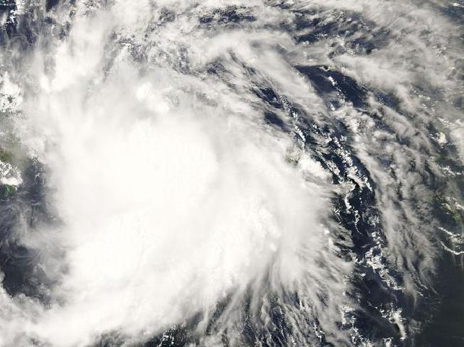  | |
| Duration | May 12 – May 16 |
|---|---|
| Peak intensity | 75 mph (120 km/h) (1-min) 982 mbar (hPa) |
On May 11, a non-tropical area of low-pressure slowly began to attain tropical characteristics as it separated from its frontal boundaries while beginning to push west. Within several hours, the mid and upper-levels of circulation became much more well-defined as its feeder bands underwent an expansion phase, therefore slightly increasing the size of the system. By May 12, the National Hurricane Center (NHC) identified a closed circulation within system coupled with 35 MPH winds, resulting in an immediate upgrade to Tropical Depression One. One continued to drift westward at an extremely slow pace of 0.9 MPH, with a Tropical Storm Watch issued for Turks & Caicos as conditions remained favorable for further development. On May 13, One underwent explosive and rapid deepening as the pressure dropped to 991 mbar, from a high 1016 mbar, in addition to developing a well-defined core structure with rising cloud tops evident on sattelite imagery. Less than an hour later, winds exceeding 45 kt were found within the core after a barge reportedly drove through the storm, reporting intense conditions. Having heard this, the NHC operationally classified the storm as Tropical Storm Arlene. By May 14, Arlene reached its peak intensity of 70 MPH as it made landfall over the northern islands of Turks & Caicos. While not operationally classified as a hurricane, Arlene brought high winds and torrential rainfall to the islands, resulting in widespread electrical failure and uprooted power lines. Trees sustained heavy damage across the islands as gusts exceeding 75 MPH resulted in smaller ones being uprooted while larger ones lost multiple limbs, some of which fell on trees and dwellings, resulting in their absolute destruction. Arlene then underwent weakening as it passed west; bringing torrential rainfall to the Bahamas that persisted for hours. Heavy flooding occurred on three islands, with Paradise Island reporting a floodwater height, including storm surge, that sat at 4.7 feet. Power outages were also common across the islands as large tree limbs snapped and fell on lines, littering yards and public roads. Due to land interaction and minimal shelving prior to landfall, Arlene weakened to 45 MPH as it made landfall in Miami, Florida.
There was no significance of Arlene's Florida landfall as damages remained minimal and no fatalities were reported. However, intense rainfall totalling nearly twelve inches resulted in slick roads and saturated ground across the state, having caused nearly three dozen vehicle accidents, though no one died as a result of this. Trees sustained damage as continoully heavy rain brought tree branches down, sometimes crushing parked cars and houses. In the Everglades, the excessive rainfall caused the ponds within the wetlands to rise seven inches above normal, resulting in the terrain throughout the area to become extremely saturated, posing sinking hazards to both animals and humans alike. Moving across the southern end of the state, heavy rain inundated homes, with nearly 14% of homes in the state becoming uninhabitable, leaving nearly 620 residents homeless following Arlene. Damages still remained fairly lower than expected, amounting to only $3.4 million. Soon After, Arlene took a direct shift NNW over Tampa, with dry air entrainment resulting in an extratropical transition. Arlene rapidly degnerated thereafter, producing heavy rain across much of the Southeast United States as it traveled up the East Coast. Some minor tornadoes were produced in Geogia and the Carolinas, though none intensified past EF0. Damage, if any, was minimal and confined solely to trees. High winds brought some trees down onto Interstate 90 in Cleveland, Ohio, resulting in partial lane closures. The remnants of Arlene later dissipated over Nova Scotia on May 18.
Post-Analysis
While operationally classified as a tropical storm, in post-season analysis Arlene was found to be a minimal hurricane at peak, with winds of 75 MPH prior to landfall in Turks & Caicos, and damage across the islands much was found to be more severe then expected, at times being compared to the damage equivalent to a Category 1 hurricane. In the spring of 2018, the NHC officially classified Arlene as a Category 1 hurricane, thus upping its wind speed to 75 MPH. This marked Arlene as the first May hurricane since Alma in the 1950s, and the most intense Atlantic tropical cyclone to form in May.
Tropical Storm Bret
| Tropical storm | |
  | |
| Duration | May 24 – May 27 |
|---|---|
| Peak intensity | 45 mph (75 km/h) (1-min) 999 mbar (hPa) |
Like Arlene, Bret developed from a non-tropical area of low-pressure drifting west across the Central Atlantic. High levels of wind shear and generally unfavorable conditions initially inhibited intensification, leaving the system a disorganized, slow-churning mess. However, the trough of wind shear the system was drifting through eventually dissipated on May 24. Soon thereafter, a gap wind event took place as the system underwent explosive deepening. Tropical Depression Two marked a rare occurrence in which the season had more then one pre-season storm to develop. The next day, Two developed strong inflow as large feeder bands began to form and wrap around the small yet unstable core of low pressure. The core continued to grow in size as its wind field began to expand, with the deepening core of low pressure resulting in an increase in wind speeds to 40 MPH, thus resulting in the storm being named Bret. Bret continued to track northwest over the next couple days as it underwent gradual weakening due to a large portion of ocean water east of Bermuda, where bret was tracking, remaining cool, despite decreasing levels of shear. By May 27, Bret's mid-level circulation began to dissipate as it slowly began unraveling, and its feeder bands separated from Bret and were absorbed by a frontal boundary, attaching itself to Bret's remnant area of low pressure. The following day, Bret's circulation was no longer visible on sattelite imagery nor radar, and any watches and warnings were discontinued. Because Bret never posed a threat to land, no damages or fatalities were reported.
Hurricane Cindy
| Category 3 hurricane | |
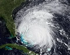  | |
| Duration | June 3 – June 9 |
|---|---|
| Peak intensity | 115 mph (185 km/h) (1-min) 958 mbar (hPa) |
At the beginning of June, the first tropical wave of the season began pushing west off the coast of Morocco. Bringing heavy rain and gusty winds to Cape Verde, the wave began pushing west while a centralized area of low pressure underwent the early stages of development around a warm core with unstable amounts of convection. Eventually, circulation began rapidly rotating around the central core, thus increasing the system's forward speed. Within the next several days, the system would go on to rapidly intensify, eventually becoming Tropical Storm Cindy 270 miles east of the Lesser Antilles on June 4. Several hours later, Cindy's convection rapidly increased in rotation speed due to an influx of moisture from the sudden shift to a very favorable environment. Cindy later made landfall over the Lesser Antilles, with the island of Dominica receiving the worst of Cindy's fury. The storm dropped over thirteen inches of rainfall in less than two hours, resulting in catastrophic flooding and a plethora of large and destructive mudslides that decimated hillsides and wrought absolute destruction upon several towns and villages. Some areas that had just finished re-building from Tropical Storm Erika in 2015 were once again decimated due to Cindy, which later became the worst modern-day tropical cyclone ever to hit the Lesser Antilles. Due to Cindy, over hundreds of thousands of people were displaced as a result of their homes being obliterated due to mudslides. Nearly $580 million exacted from Cindy, with most of the damages resulting from the torrential rainfall and landslides. Following Cindy, the island of Dominica was declared a Federal Disaster Area by the United States Government, and emergency relief and supplies were airlifted into the country immediately following Cindy as it began to track NNW.
The western ends of the islands received another indirect hit from Cindy only hours after it first began tracking WNW; an outer band lined with intense storms later swept over the islands. A lack of moisture and uneven heating at different elevations resulted in a catastrophic wind event across the northern parts of the Lesser Antilles. Winds exceeding nearly 70 MPH in strength added to the already catastrophic damage, with the threats of wildfire from lightning and dry thunderstorms resulting in an immediate halt of the airlifting of supplies to the islands. Due to Cindy's wind, which at times would often exceed hurricane strength, roofs were torn off homes across region, with debris from destroyed buildings becoming airborne and sometimes striking people; mainly those who did not have refuge in the second half of the storm because their homes were entirely destroyed. Power across the region was out completely, as the sheer levels of damage thrust upon power lines and electrical plants would require months of time and money to fix. The following day, Cindy had passed over Hispaniola and Puerto Rico, bringing heavy rains and high winds that caused an estimated $6.5 million in damages, with no fatalities. Soon after, Cindy underwent rapid expansion and explosive deepening as sudden bursts of convection triggered explosive intensification within Cindy's core; it became a Category 1 hurricane on that same day, June 5, in the near-exact same spot as where Arlene attained hurricane intensity. This development led the NHC to up their forecasts for a Category 1 hurricane at peak, with the storm taking a track similar to Arlene. However, Arlene passed over the Caicos islands on June 6 as a 90 MPH Category 1; trying to develop an eye. Heavy rains and high winds battered the islands for the majority of the day, causing sporadic power outagesm with some lines just repaired from Arlene once again getting destroyed by Cindy. In additon, large amounts of trees were downed due to high winds, with larger ones being partially defoliated. Some trees were blown onto cars and roads, which resulted in temporary closures across the islands. A couple in Cockburn Town was killed after a tree was blown onto a parked car in which the two sat in. Prior to moving into the Bahamas, Cindy's eyewall underwent rapid expansion and as a result explosively intensified into a Category 3 hurricane - the first major hurricane of the season and the strongest Atlantic tropical cyclone to form in June. With 120 MPH wind speeds, Cindy wrought the worst damage across the Bahamas since Joaquin in 2015. Nearly 30% of housing throughout the region was somehow damaged, from homes losing their roofs to being rendered uninhabitable due to floodwaters. Over 200 homes total across all islands combined were enitrely destroyed by Cindy, displacing and leaving over 900 people homeless. In total, heavy damage amounted due to Cindy, which caused $201.6 million in damages solely in the Bahamas, in addition to claiming the lives of 17 people.
Cindy explosively weakened as it approached southern Florida, posing the first great hurricane threat to the state Erika of 2015; Cindy weakened to 100 MPH as it made landfall over Ft. Lauderdale, becoming the first hurricane landfall in the state since Wilma of 2005. Cindy caused widespread damage across the state, with a majority of trees being uprooted or defoliated in the high winds. Some tree limbs were blown onto roads, causing temporary closures of main highways across the state. In addition, parked cars sustained damage when tree branches were blown onto them. Miami also encountered tropical-storm force winds from Cindy; frame houses had roof shingles blown off and shutters and awnings ripped from their supports. Power lines in Ft. Lauderdale were heavily damaged by trees, flying debris, and high winds. Over 80,000 people lost power during Cindy due to snapped lines and/or uprooted utility poles. Cindy's storm surge was relatively low in height; having peaked at 2.76 feet. This was because Cindy struck at low tide, with relatively minimal flooding from storm surge reported during the storm's Florida landfall. As Cindy pushed across the state, it underwent massive weakening into a weak tropical storm, soon becoming extratropical over Tampa. Cindy then began pushing northwest across the Gulf of Mexico, making one last landfall in Pensacola, Florida as a weakened extratropical depression prior to dissipating several hours later. Overall, Cindy's damage was considerable, having amounted to $708.6 million whilst causing 21 deaths.
Tropical Depression Four
| Tropical depression | |
  | |
| Duration | June 28 – June 30 |
|---|---|
| Peak intensity | 30 mph (45 km/h) (1-min) 1013 mbar (hPa) |
Tropical Depression Four was a brief depression in late June. The 4th tropical cyclone of the 2017 Atlantic Hurricane Season, TD 4 formed from an early-season African Easterly Wave. The wave had traversed the Atlantic for 10 days, stalling in certain places due to very weak steering patterns. Before becoming TD 4, the precursor brought light showers to Cape Verde and the Carribean Islands, bringing some light flooding. The wave finally organized into TD 4 off of the coast of South Carolina on June 28th automatically reaching its peak of 30 MPH and 1013 Mbars. TD 4 once again stalled and brought flash flooding to the South Carolina coastline. TD 4 caused moderate beach erosion throughout the South Carolina coastline, as well. The only damage reported from TD 4 was minor flood damage on the direct coast, with $2 Million (2017 USD) in total damages. Tropical Depression 4 did not last long, due to dry air moving in from the east, infiltrating the center of circulation. In the early hours of June 30th, TD 4's circulation became less and less defined, and by evening TD 4 dissapated entirely. TD 4's remnants made landfall in Deleware, bringing light showers and light wind damage. No fatalities were reported from this system during its period of life as a Tropical Depression, but 1 was reported from TD 4's precursor in Haiti from a fisherman lost a sea.
Tropical Storm Don
| Tropical storm | |
  | |
| Duration | July 1 – July 6 |
|---|---|
| Peak intensity | 50 mph (85 km/h) (1-min) 994 mbar (hPa) |
Tropical Storm Don formed on July 1st as Tropical Depression 5 from a non-tropical low pressure system just east of the Barbados. The conditions in the area were largely unconducive to development, so forcasting agencies were not expecting Don to gain much intensity. Don later made landfall on Barbados as a Tropical Depression, bringing heavy rainfall and thunderstorms to the island. Don, then known as TD 5, moved into the Carribean, where conditions became slightly more conducive to development. Hurricane Hunters found that TD 5 has intensified to 40 MPH, and it was given the name Don. Don continued to intensify, reaching a peak intensity of 50 MPH and 994 Mbars. Don then began to quickly weaken as conditions rapidly became less conducive. Don quickly weakened to a Tropical Depression and made landfall in Nicaragua, later dissapating on July 6th. The remnants of Don went on to form Emily, which became a Category 4.
Hurricane Emily
| Category 4 hurricane | |
 | |
| Duration | July 19 – July 27 |
|---|---|
| Peak intensity | 155 mph (250 km/h) (1-min) 921 mbar (hPa) |
On July 18, the NHC identified a tropical wave beginning to push off the coast of Morocco westward over the Central Atlantic. Under favorable conditions, the wave steadily organized whilst bringing thundershowers and rainy conditions to Cape Verde that resulted in significant flooding. By July 19, the wave had begun to take on a cyclonic shape while a surface low underwent the beginning phases of development within the core. Steady bands of showers and thunderstorms began forming in the inner layers of circulation, which gradually grew more annular in nature as the storm eventually intensified into Tropical Depression Six. The following day, wind speeds had increased to 45 MPH, and closed circulation became so well-defined the storm was upgraded to Tropical Storm Emily. Within hours, a ring of convection had fully developed around the outer edges of the developing eye feature, making many believe Emily would be a powerful and long-lived annular hurricane. Over the following days, Emily retained intensity as it later intensified to 70 MPH while pushing west across the Central Atlantic. On July 21, an uproar of convection occurred in Emily's core, while a plume of moisture developing within the eyewall resulted in a substantial improvement in Emily's cloud patterns. Due to the sudden intensification, Emily later strengthened into a Category 2 hurricane with 105 MPH winds. In addition to this, a trough of westerly wind shear that had largely inhibited initial intensification further unexpectedly dissipated, resulting in a large increase in Emily's forward speed to 48 MPH. The following day, Emily was forecasted to make landfall over the Virgin Islands as a Category 3 major hurricane.
A powerful directional trough to Emily's south with increasing outflow resulted in an unexpected shift in direction while it sat just to the east of the Windward Islands. Emily turned directly north but an eastward frontal system to Emily's north once again induced another directional change as it strengthened into a 130 MPH Category 4 hurricane just east of Puerto Rico. On July 23, Emily attained its peak intensity of 155 MPH just north of Puerto Rico, which was battered for two days by Emily due to the storm's extremely slow movements westward over the Greater Antilles. High winds buffeted buildings and tore the roofs off thousands of homes throughout the region. Trees across the island were defoliated, with entire palm forests being flattened by the strong winds. Electrical pylons and communication towers were downed and deformed completely by the hurricane, with damages so extensive some stations took their services offline permanently. Emily's storm surge moved inland for nearly two miles, having swept houses off their foundations and inundating thousands more. In San Juan, high-rises were stripped of their windows and sea walls were smashed by strong waves. Power across the island was completely out of service as Emily downed lines across the nation. The next day, Emily's western eyewall brushed the Dominican Republic, pounding the island with strong waves and a deadly storm surge. Pounding surf from Emily overturned boats in their harbors and smashed sea walls, in addition to inundating coastal properties and collapsing sea side bridges. Emily also brought torrential rainfall to Haiti, in which the storm contaminated the water supply there, resulting in a severe rebound of the cholera epidemic, which spread across much of the country and even into the Dominican Republic due to the fooding. Across the Greater Antilles, Emily became the worst hurricane to strike the area since Hurricane Georges of 1998, which took the same path through the area at a nearly identical intensity. On July 25, Emily shifted NNW towards the Turks & Caicos, slamming the islands with winds of 145 MPH - having become the worst hurricane to make landfall there in history. Emily caused extreme damage across the entire archipelago; radio and communication towers were downed and crumpled at the height of the storm. Heavy rains and damaging winds caused massive property damage, and nearly all trees and native flora were defoliated by Emily's powerful winds. Throughout the Greater Antilles, Emily caused $34.7 billion in damages, in addition to claiming over 5,328 lives; this made it the deadliest Atlantic hurricane since Katrina in 2005.
As Emily continued to track northwards, it underwent slight weakening due to the presence of dry air embedded in the circulation. However, it retained its Category 4 intensity as it moved through the northern end of the Bahamas. Damaging and life-threatening swells caused catastrophic flooding throughout the archipelago; with Crooked Island being the worst affected. Thousands of homes were inundated and later deemed uninhabitable to flooding, displacing thousands of people. Already destroyed by Hurricanes Arlene and Cindy earlier in the season, Paradise Island and the Grand Bahama were heavily affected by Emily as it tore through the area, subjecting the islands to winds of 140 MPH.
Hurricane Franklin
| Category 1 hurricane | |
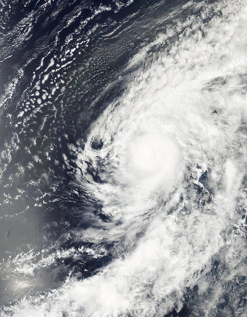 | |
| Duration | July 20 – July 26 |
|---|---|
| Peak intensity | 90 mph (150 km/h) (1-min) 981 mbar (hPa) |
Hurricane Franklin was a Category 1 hurricane that formed in late July. The 7th tropical cyclone, 6th named storm, and 4th hurricane of the 2017 Atlantic Hurricane Season, Franklin formed from a tropical wave that came off the coast of Africa on July 20. Franklin began to rapidly intensify and quickly became Tropical Depression 7. Soon after, TD 7 became a tropical storm, and was given the name Franklin. Franklin continued to intensify and quickly reached Category 1 intensity, prompting the second time hurricane warnings had to be issued for Cape Verde, the first time being from Hurricane Fred in 2015, which was also a Category 1 and was only slightly weaker then Franklin. Hurricane Franklin then went on to reach a peak intensity of 90 MPH and 981 Mbars. Hurricane Franklin lashed Cape Verde at peak intensity with strong winds and heavy rain. Minor flooding from rain and storm surge was reported, but damage wasn't particularly bad. Franklin then continued to move northwest, almost identically to Fred, and began to encounter cooler water temperatures. Franklin gradually started to weaken. Franklin got caught on the Jet Stream, which had mysteriously reversed directions a couple days earlier, and was now helping Franklin cross the Atlantic rapidly, which delayed weakening. Franklin lost hurricane intensity about 500 miles east of Bermuda. Thereafter, Franklin only slightly weakened to 60 MPH and made landfall on Bermuda at that intensity. Franklin brought sporadic power outages to the island, and all damage was mainly confined to trees and roof shingles, except for a church on the island, where an electrical fire started after the roof caved in. The cause of the collapse is unknown. Total damage on the island accounted to about $800 million (2017 USD), mainly from the church roof collapse and electrical fire. Franklin the began to rapidly weaken due to wind shear and dry air, and dissapated on July 26, about 200 miles east of North Carolina, after tracking nearly 3,500,000 miles across the Atlantic Ocean in a little over then 6 days.
Tropical Storm Gert
| Tropical storm | |
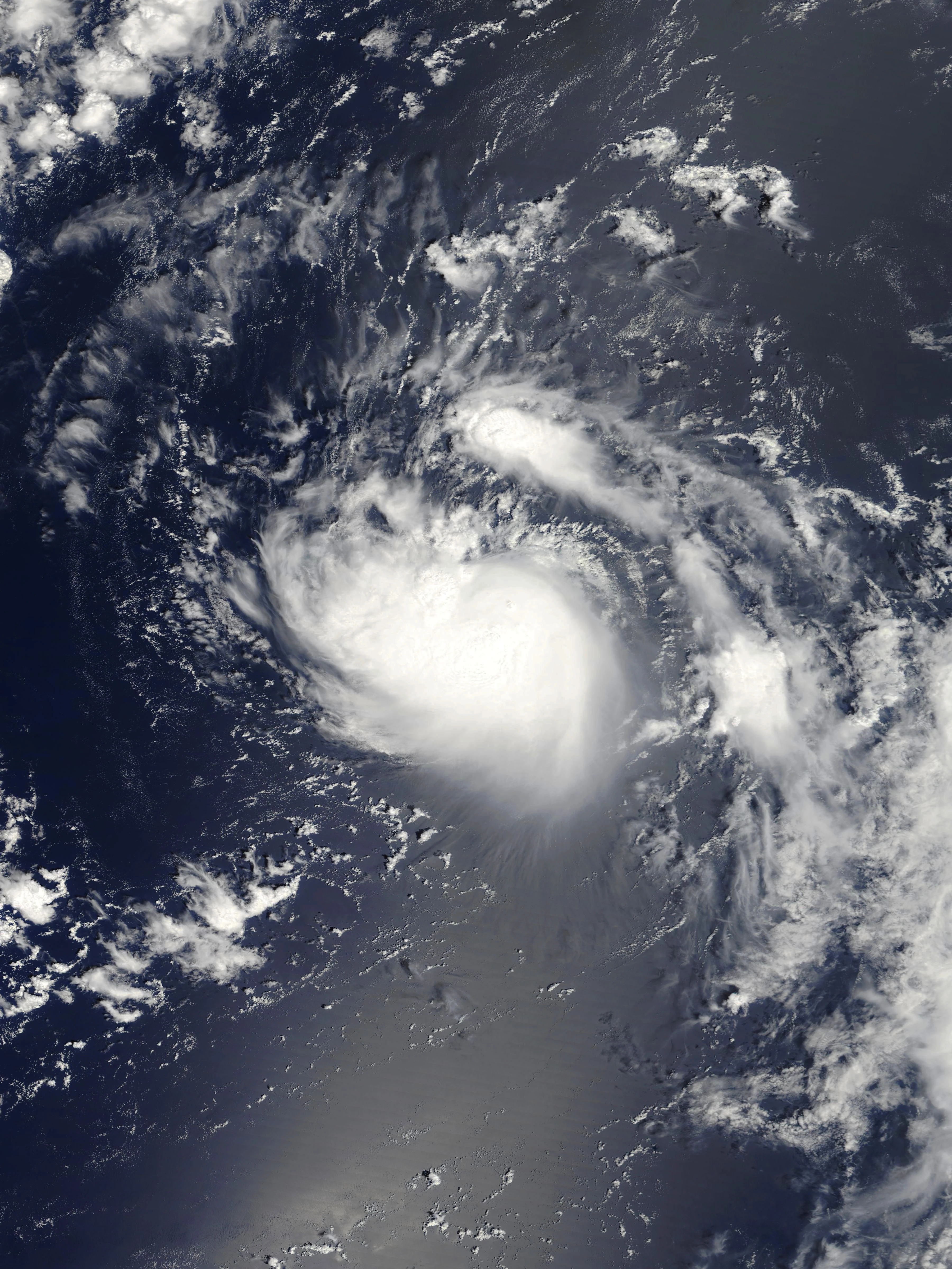  | |
| Duration | August 2 – August 6 |
|---|---|
| Peak intensity | 40 mph (65 km/h) (1-min) 1002 mbar (hPa) |
Tropical Storm Gert was a weak Tropical Storm in early-August and was the 8th Tropical Cyclone and 7th Named Storm of the 2017 Atlantic Hurricane Season. On August 2, the NHC analyzed the remnants of a extratropical cyclone that had come off the coast of North Carolina. Over the next day, the remnants consolidated and by early-morning August 3, the NHC classified the now well organized remnants as Gert, skipping the Tropical Depression stage, which is common in Tropical Cyclones that form from non-tropical origins. Gert soon reached its peak intensity of 40 MPH and a pressure of 1002 Mbars. Gert was expected to begin to weaken soon and was predicted to dissapate within 48 hours; as it was in a very unfavorable environment with high wind shear and dry air to its north, west, and east. On Augest 4, it was beginning to be noticable that wind shear was rapidly shearing away Gert's outer edges. Dry air soon took its toll on Gert as well, as the cloud patterns became less defined. On Augest 5, NHC announced that Gert had weakened to a remnant low, and would discontinue advisories for this system. Gert's remnants continued north and made landfall in Nova Scotia, bringing rain and foggy conditions.
Hurricane Harvey
| Category 4 hurricane | |
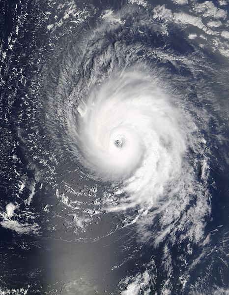 | |
| Duration | August 6 – August 19 |
|---|---|
| Peak intensity | 150 mph (240 km/h) (1-min) 924 mbar (hPa) |
A tropical disturbance developed over Central Africa around August 3. It gradually moved westward towards the Atlantic Ocean. As it exited the coast on August 6, favorable conditions allowed the wave to rapidly develop as it approached Cape Verde. The disturbance quickly became a tropical storm, and was named Harvey.
Tropical Storm Irma
| Tropical storm | |
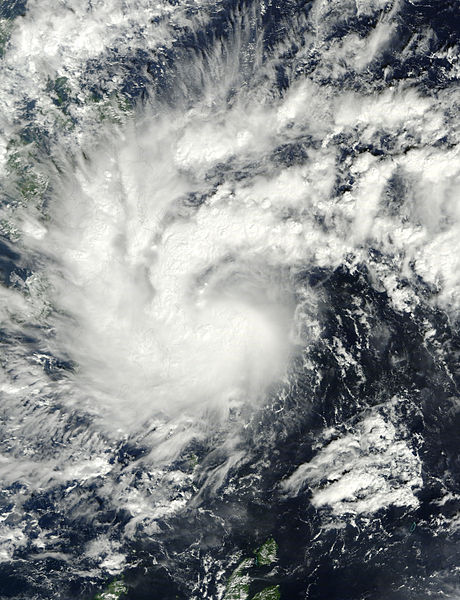  | |
| Duration | August 9 – August 12 |
|---|---|
| Peak intensity | 65 mph (100 km/h) (1-min) 997 mbar (hPa) |
Tropical Storm Irma was a moderate tropical storm in mid-August. The 10th named storm of the 2017 Atlantic Hurricane season formed on Augest 9th as Tropical Depression 11 in the Gulf of Mexico. TD 11 slowly intensified, reaching Tropical Storm status on Augest 10th, and was named Irma by the NHC. Irma slowly continued to intensify, reaching a peak of 65 MPH and a pressure of 997 Mbars. Irma then made landfall in Port Arthur, Texas, on Augest 12th, dissapating soon after due to land interaction. Irma caused the shut down of multiple oil refineries around Port Arthur in fears of damage. The refineries soon reopened, though, as damage wasn't as bad as expected.
Hurricane Jose
| Category 1 hurricane | |
 | |
| Duration | August 13 – August 20 |
|---|---|
| Peak intensity | 85 mph (140 km/h) (1-min) 976 mbar (hPa) |
Hurricane Katia
| Category 4 hurricane | |
 | |
| Duration | August 18 – August 31 |
|---|---|
| Peak intensity | 155 mph (250 km/h) (1-min) 924 mbar (hPa) |
Tropical Depression Thirteen
| Tropical depression | |
 | |
| Duration | August 20 – August 20 |
|---|---|
| Peak intensity | 35 mph (55 km/h) (1-min) 1011 mbar (hPa) |
Hurricane Lee
| Category 4 hurricane | |
 | |
| Duration | August 24 – September 2 |
|---|---|
| Peak intensity | 150 mph (240 km/h) (1-min) 912 mbar (hPa) |
Tropical Storm Maria
| Tropical storm | |
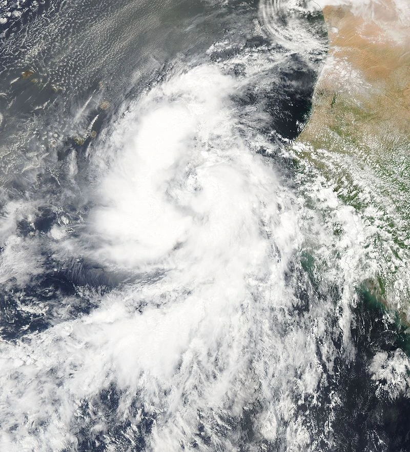 | |
| Duration | August 31 – September 2 |
|---|---|
| Peak intensity | 45 mph (75 km/h) (1-min) 996 mbar (hPa) |
Hurricane Nate
| Category 5 hurricane | |
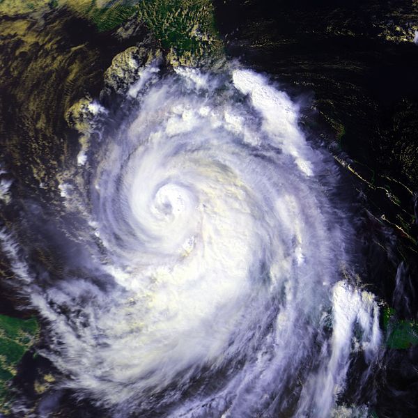 | |
| Duration | September 6 – September 22 |
|---|---|
| Peak intensity | 165 mph (270 km/h) (1-min) 914 mbar (hPa) |
Hurricane Ophelia
| Category 5 hurricane | |
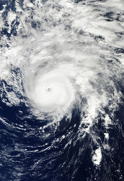 | |
| Duration | September 13 – September 26 |
|---|---|
| Peak intensity | 160 mph (260 km/h) (1-min) 917 mbar (hPa) |
Tropical Depression Eighteen
| Tropical depression | |
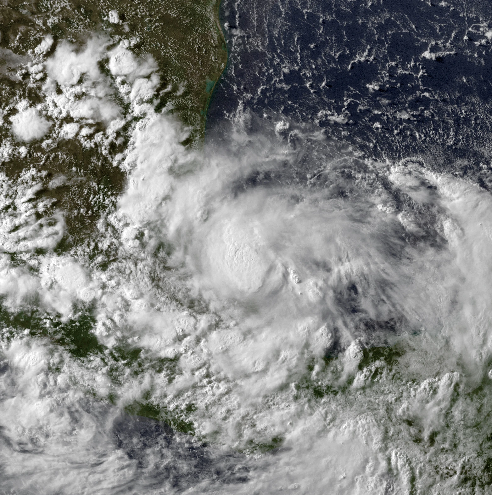 | |
| Duration | September 15 – September 16 |
|---|---|
| Peak intensity | 30 mph (45 km/h) (1-min) 1003 mbar (hPa) |
Tropical Storm Philippe
| Tropical storm | |
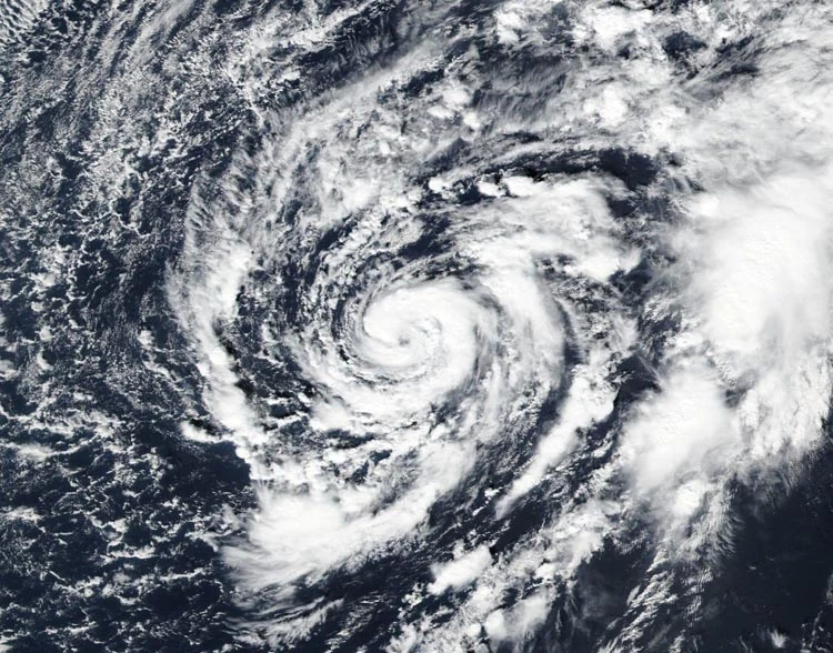 | |
| Duration | September 16 – September 18 |
|---|---|
| Peak intensity | 45 mph (75 km/h) (1-min) 995 mbar (hPa) |
Hurricane Rina
| Category 5 hurricane | |
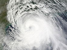 | |
| Duration | September 22 – October 4 |
|---|---|
| Peak intensity | 175 mph (280 km/h) (1-min) 903 mbar (hPa) |
Tropical Depression Twenty-One
| Tropical depression | |
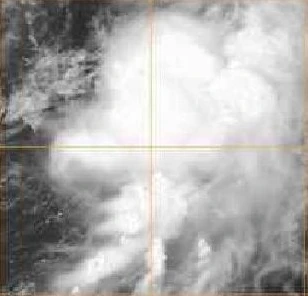 | |
| Duration | September 26 – September 29 |
|---|---|
| Peak intensity | 35 mph (55 km/h) (1-min) 1001 mbar (hPa) |
Hurricane Sean
| Category 2 hurricane | |
 | |
| Duration | October 11 – October 23 |
|---|---|
| Peak intensity | 105 mph (165 km/h) (1-min) 972 mbar (hPa) |
Tropical Storm Tammy
| Tropical storm | |
 | |
| Duration | Unknown – Unknown |
|---|---|
| Peak intensity | 40 mph (65 km/h) (1-min) 1009 mbar (hPa) |
Tropical Storm Vince
| Tropical storm | |
 | |
| Duration | Unknown – November 5 |
|---|---|
| Peak intensity | 50 mph (85 km/h) (1-min) 999 mbar (hPa) |
Hurricane Whitney
| Category 1 hurricane | |
 | |
| Duration | Unknown – Unknown |
|---|---|
| Peak intensity | 85 mph (140 km/h) (1-min) 982 mbar (hPa) |
Tropical Storm Alpha
| Tropical storm | |
 | |
| Duration | Unknown – January 3, 2018 |
|---|---|
| Peak intensity | 60 mph (95 km/h) (1-min) 997 mbar (hPa) |