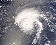
The 2018 Atlantic hurricane season was a hyperactive and catastrophic hurricane season,featuring 21 named storms, 16 hurricanes and 7 major hurricanes – ranking it alongside 1936 as the second-most active season since records began in 1851. The season also featured both the highest total accumulated cyclone energy (ACE) and the highest number of major hurricanes since 2005 and surpassing the last year,it was the second costliest season on record,only under 2017, with a total of at least $205.45 billion (USD 2018) in damages,this season featured two category 5 hurricanes.similar to 2017.This season is the only season on record in which three hurricanes each had an ACE of over 40: Alberto,Isaac and Oscar.
The season officially began on June 1 and ended on November 30. These dates historically describe the period of year when most tropical cyclones form in the Atlantic basin. However,this season featured three system before first of June,tho of them was named storms, the formation of tropical cyclones is possible at other times of the year.
Initial predictions for the season anticipated that an El Niño would develop from September, lowering storm activity. However, the predicted El Niño failed to develop, with cool-neutral conditions developing instead, later progressing to a La Niña – the second one in a row. This led forecasters to upgrade their predicted totals, with some later anticipating that the season could be the most active since 2012.
Beginning in 2017, the National Hurricane Center has the option to issue advisories, and thus allow watches and warnings to be issued, on disturbances that are not yet tropical cyclones but have a high chance to become one, and are expected to bring tropical storm or hurricane conditions to landmasses within 48 hours. Such systems are classified as "Potential Tropical Cyclones".But in this season,none storm had that category.
Seasonal Forecasts[]
| Source | Date | Named storms |
Hurricanes | Major hurricanes |
|
| Average (1981-2010) | 12.1 | 6.4 | 2.7 | ||
| Record high activity | 28 | 15 | 7 | ||
| Record low activity | 4 | 2† | 0† | ||
| ––––––––––––––––––––––––––––––––––––––––––––––––––––––– | |||||
| MBR | December 12, 2017 | 17-20 | 4-6 | 2-4 | |
| TSR | March 24, 2018 | 16-18 | 8-10 | 3-6 | |
| CSUC | April 12, 2018 | 18 | 5 | 3 | |
| OSMC | May 15, 2018 | 22 | 10 | 6 | |
| NOAA | June 1, 2018 | 20 | 8 | 4 | |
| GFS | June 8, 2018 | 18 | 12 | 5 | |
| TSR | July 1, 2018 | 18-25 | 13-17 | 6-8 | |
| ––––––––––––––––––––––––––––––––––––––––––––––––––––––– | |||||
| Actual activity |
20 | 14 | 6 | ||
| † Most recent of several such occurrences. (See all)
* June–November only | |||||
Ahead of and during the season, several national meteorological services and scientific agencies forecast how many named storms, hurricanes, and major hurricanes (Category 3 or higher on the Saffir–Simpson scale) will form during a season, and/or how many tropical cyclones will affect a particular country. These agencies include the Tropical Storm Risk (TSR) Consortium of the University College London, the National Oceanic and Atmospheric Administration (NOAA),the Olo Storm Meteorological Center (OSMC) and Colorado State University (CSUC). The forecasts include weekly and monthly changes in significant factors that help determine the number of tropical storms, hurricanes,and major hurricanes within a particular year.On average, an Atlantic hurricane season between 1981 and 2010 contained twelve tropical storms, six hurricanes, and two major hurricanes, with an Accumulated Cyclone Energy (ACE) index of between 66 and 103 units.
Storms[]
|
Timeline[]

Systems[]
Hurricane Alberto[]
| Category 4 hurricane (SSHWS) | |
  | |
| Duration | May 2 – May 4 |
|---|---|
| Peak intensity | 145 mph (230 km/h) (1-min) 928 mbar (hPa) |
On May 2, a stationary tropical wave formed northeast of Columbus. It did not develop until a bag of unusually low shear formed in the storm environment, on late May 2, when it became Tropical Storm Alberto,in 12 hours it was initially upgraded into a hurricane on July 30,and suffer a period of very rapid intensification, unexpectedly reaching category 4, but it did not maintain this peak for long,and it weakened back to a tropical storm due to wind shear. Shear,dissipating late in May 4.
Alberto made landfall on Guyana,being the first cyclone to make landfall in that country as a tropical storm, leaving $150 million (2018 USD) in damage in the country, 18 deaths were reported there.As a tropical storm, Alberto produced a maximum of 17.82 inches of rainfall in Guyanas. The rainfall was responsible for flooding that caused moderate crop damage.
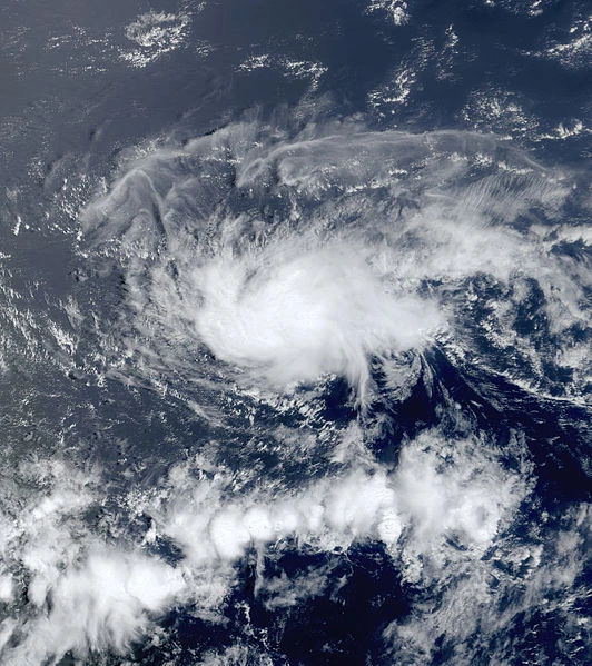
Tropical Depression 02[]
| Tropical depression (SSHWS) | |
  | |
| Duration | May 19 – May 20 |
|---|---|
| Peak intensity | 30 mph (45 km/h) (1-min) 1012 mbar (hPa) |
An tropical low, which had shown signs of transition for a couple days, developed into Tropical Depression 02 on May 19. Despite strong wind shear, it organized to become a depression. The depression rapidly dissipated on May 20,only minimal damages were reported.
Tropical Storm Beryl[]
| Tropical storm (SSHWS) | |
  | |
| Duration | May 31 – June 4 |
|---|---|
| Peak intensity | 65 mph (100 km/h) (1-min) 992 mbar (hPa) |
A tropical low entered the Caribbean sea.With a medium wind shear,it intensified to a tropical storm,On June 4, Beryl made landfall in Texarcana, TX, as a tropical storm After landfall, the system rapidly weakened and dissipated in only six hours.
The storm caused coastal flooding which closed roads and forced the evacuation of residents. Louisiana and Texas received high wind gusts, heavy rainfall, and strong surf that resulted in the deaths of 28 persons. Throughout the states, 40,000 homes lost electricity.The storm caused a total of about $120 million (2018 USD) in damage.
Hurricane Chris[]
| Category 2 hurricane (SSHWS) | |
  | |
| Duration | June 8 – June 14 |
|---|---|
| Peak intensity | 105 mph (165 km/h) (1-min) 968 mbar (hPa) |
A tropical wave in the pacific began interacting with a other tropical low over Central America. The two waves converged in one and started to travel over Caribbean waters. Because of this, Tropical Depression 04 formed on June 9 .The depression intensified into Tropical Storm Chris on June 10, and nearly made landfall over the Yucatan shortly after.and started intensifying very fast at the time it traveled fast to the north.On June 12, Chris made landfall in Poches, Florida with winds of 100 mph and a pressure of 970 millibars, rapidly becoming post-tropical later in next day.
The storm dropped heavy rainfall, peaking at 24.77 inches (629.2 mm) in Pico Chayo, in south Nicaragua.The rainfall caused mudslides and damage, In USA, the hurricane produced significant damages in Florida and all west coast.Overall, the storm resulted in 118 deaths and $1030 million in damage (2018 USD).
Hurricane Debby[]
| Category 1 hurricane (SSHWS) | |
  | |
| Duration | June 12 – June 20 |
|---|---|
| Peak intensity | 80 mph (130 km/h) (1-min) 982 mbar (hPa) |
A subtropical system made movement over the Gulf Stream and baroclinic processes caused the storm to deepen, rapidly intensifying and named with the storm becoming a Category 1 hurricane on June 22. Although it soon weakened to a Category 1 hurricane, the barometric pressure decreased to 990 mbar, At 1200 UTC,Debby became extratropical, while located just inland New York. The center of the now extratropical storm moved inland over Great Lakes late on June 16.And traveled as a subtropical over Great Lakes,dissipating over Canada on June 20.
The center of Hurricane Debby directly cross over New York City.The hurricane produced intense storm surge, which resulted in extensive flooding in all city.Strong winds caused the falling of trees,and damaged houses, and the hurricane was responsible for ten direct deaths and two indirect deaths.The money loses remain unknow.
Hurricane Ernesto[]
| Category 2 hurricane (SSHWS) | |
  | |
| Duration | June 23 – June 26 |
|---|---|
| Peak intensity | 105 mph (165 km/h) (1-min) 971 mbar (hPa) |
A shortwave disturbance spawned a well-defined low pressure area on June 22 .The low moved north and developed into Tropical Depression Six on June 23. It moved northwestward and strengthened into Tropical Storm Ernesto on late June 23,due of favorable conditions, the storm rapidly intensified. Late on June 24, it was upgraded to a hurricane, before becoming a Category 2 hurricane early on the following day.Strength and attained its peak intensity with maximum sustained winds of 105 mph (165 km/h) and a minimum barometric pressure of 971 mbar. Thereafter, it weakened back to a Category 1 hurricane later on June 25. The storm curved back to the northwest and resumed weakening later that day, due to encountering wind shear, rapidly degenerating in a remnant on June 26.The storm never threatened land.
Tropical Storm Florence[]
| Tropical storm (SSHWS) | |
  | |
| Duration | July 2 – July 5 |
|---|---|
| Peak intensity | 45 mph (75 km/h) (1-min) 1001 mbar (hPa) |
A large area of clouds, developed over the Western Caribbean on July 2. Despite of hight wind shear,it quickly developed, being declared Tropical Depression Seven on July 3. Eighteen hours later, it intensified into Tropical Storm Florence, and made landfall in Veracruz on July 5, before dissipating over the mountains in same day.
The system was producing heavy rain over the state of Veracruz and Yucatán until dissipating over the mountains of San Luis Potosí late on July 5.Hundreds of homes were damaged, and several towns were severely flooded, but the only reported fatalities were three man that died in a landslide.
Hurricane Gordon[]
| Category 4 hurricane (SSHWS) | |
  | |
| Duration | July 4 – July 14 |
|---|---|
| Peak intensity | 140 mph (220 km/h) (1-min) 937 mbar (hPa) |
A tropical wave emerged off the coast of Africa. Which traveled for several days, until a Tropical Depression formed on July 14 It intensified into Tropical Storm Gordon, and began a to travel to the west.Gordon moved north of great Antilles, getting better organized and intensified into a hurricane on late July 16. With very warm waters and moderate shear,the storm intensified into a major hurricane on July 18,attaining peak winds of 140 mph, and travelling to the north,bringing dangerous rogue sea in all Usa west coast,became extratropical and dissipating in July 14 near Nova Scotia.
The hurricane did not make landfall,but the storm was causing extensive damage in the Bahamas.Gordon moved north and became extratropical late on July 13 near Nova Scotia, but it continued northeastward, producing strong winds and heavy rain over Atlantic Canada.None deaths were reported. Damage is estimated at around $10 million, mostly in North Carolina but also in the Bahamas and Nova Scotia.
Hurricane Helene[]
| Category 3 hurricane (SSHWS) | |
  | |
| Duration | July 9 – July 16 |
|---|---|
| Peak intensity | 120 mph (195 km/h) (1-min) 949 mbar (hPa) |
On July 9, a tropical wave developed into a tropical depression,very close of hurricane Gordon. Moving northwestward, the depression became Tropical Storm Helene on July 11, and strengthened further and deepened to attain its peak intensity with maximum sustained winds of 120 mph (195 km/h) on July 12. The system weakened as it entered cooler water temperatures and began a gradual transition to an extratropical cyclone, a process it completed by July 14. The extratropical low was absorbed by a larger weather system on the following day.
Throughout the North Antilles and Bahamas, Hurricane Helene caused severe damage. Torrential rainfall and mudslides caused by the storm killed at least 251 people,the extratropical Helene caused some damages in New York and Canada,but none deaths were reported in that zone.Around 16000$ in damages
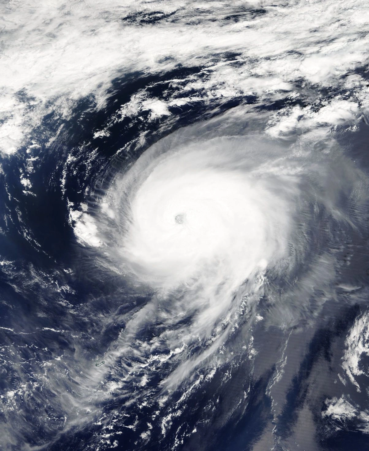
Hurricane Isaac[]
| Category 5 hurricane (SSHWS) | |
  | |
| Duration | July 13 – August 1 |
|---|---|
| Peak intensity | 160 mph (260 km/h) (1-min) 919 mbar (hPa) |
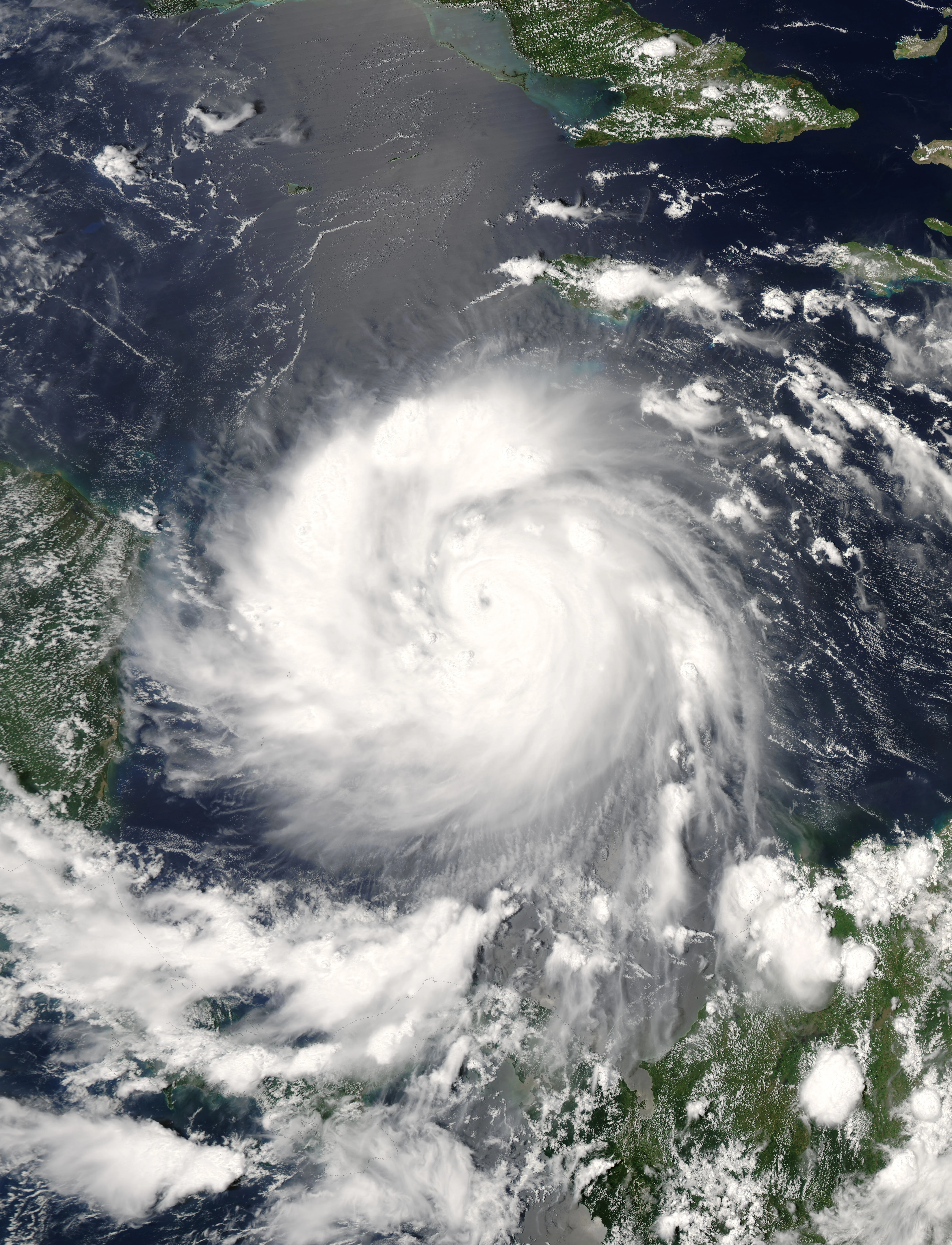
On July 13, a tropical wave moved off the west coast of Africa, and, encountering favorable conditions, quickly spawned Tropical Depression.The depression moved briskly westward and was upgraded to Tropical Storm Isaac on July 14.The storm continued to strengthen as it gained organization,and became a hurricane.On July 20 the eye of the hurricane passed into the middle Leeward Islands as a category 4.In the warm waters of the Caribbean, Isaac rapidly strengthened into a Category 5 hurricane with 160 mph (260 km/h) sustained winds. It made landfall on the Yucatán Peninsula of Mexico on July 25.Isaac weakened over land, but re-intensified slightly in the Gulf of Mexico. It made its final landfall near Tecolutla, Veracruz on July 29, dissipating in some days.
Hurricane Isaac effects were very severe.Hurricane Isaac made landfall just in the Northern Tip of Nicaragua, as a Category 4 hurricane with 140 mph (220 km/h) winds and later landfalls in Yucatán, and Northeastern Mexico.In all,Isaac killed at least 1200 people,and damage totaled $30400 million of dollars.
Tropical Storm Joyce[]
| Tropical storm (SSHWS) | |
  | |
| Duration | July 23 – August 4 |
|---|---|
| Peak intensity | 45 mph (75 km/h) (1-min) 981 mbar (hPa) |
a large wave that formed off the coast on July 22. It deepened steadily along a cold front that pushed through Florida. When the system lost most of its baroclinic support, development ceased until its low moved into warmer waters near the Bahamas.Favorable conditions allowed the storm to generate deeper convection much closer to the center.By July 25 the storm attained his peak of intensity,but a mid level ridge deteriorated the storm as it moved southward into an environment with higher wind shear. By July 31 Joyce had lost all significant convection and degenerated into a remnant low.and later in a extratropical system.
Joyce produced heavy rainfall in Bahamas,Florida and South Carolina, causing flooding and mudslides which damaged or destroyed 1,500 homes,but none deaths were reported.Torrential rain affected South Florida and the Bahamas,the storm produced strong winds over all USA and Canada east coast.Overall damage was minor, estimated at $300 million.
Hurricane Kirk[]
| Category 2 hurricane (SSHWS) | |
  | |
| Duration | August 7 – August 14 |
|---|---|
| Peak intensity | 95 mph (155 km/h) (1-min) 972 mbar (hPa) |
A Tropical wave moved off the coast of Africa on August 6. A broad area of low pressure developed in association with the wave as it passed southwest of Cape Verde.By 12:00 UTC on August 9, the wave developed into a tropical depression about 460 mi (740 km) southwest of Cape Verde. An unusually weak subtropical ridge steered the system northwest, and then north again over subsequent days.The depression intensified into Tropical Storm Kirk six hours after formation.A more favorable environment allowed Kirk to attain hurricane intensity by 20:00 UTC on August 10 and attained peak winds of 95 mph (155 km/h) eighteen hours later as a category 2 hurricane.Progressively cooler waters and stronger shear caused Kirk to weaken to a tropical storm and then weaken to a tropical depression early on August 13 and degenerate into a remnant low.The remnant low moved northwest and crossed of the Azores.
As Kirk passed to the southwest of the Cape Verde islands on August 10, outer rain bands produced minor rainfall, totaling around 12 inches .There were no reports of damage or flooding from the rain and overall effects were minor.No known damage was caused by the storm.
Hurricane Leslie[]
| Category 1 hurricane (SSHWS) | |
  | |
| Duration | August 9 – August 16 |
|---|---|
| Peak intensity | 80 mph (130 km/h) (1-min) 962 mbar (hPa) |
A area of low pressure formed of the Hurricane Kirk moisture, organizing into a tropical depression by 18:00 UTC on August 9.Steered northwest and then sharply northeast ahead of an approaching cold front, the system intensified into Tropical Storm Leslie six hours after formation. Within an environment of low wind shear, Leslie strengthened into a hurricane and attained peak winds of 80 mph (130 km/h) by 00:00 UTC on August 13 as an eye became apparent,The storm became increasingly asymmetric as it interacted with the front, and Leslie transitioned into an extratropical cyclone by 18:00 UTC that day. The extratropical system was completely absorbed by the front and Kirk remnants six hours later and traveled to Europe.
Although Leslie passed through the Azores Islands, the storm had little known effects there.In Europe, the system and its remnants brought rain to several countries, including Portugal,Spain and France,seven fatalities were linked to Leslie and overall damage was minimal.
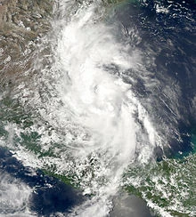
Hurricane Michael[]
| Category 1 hurricane (SSHWS) | |
  | |
| Duration | August 14 – August 20 |
|---|---|
| Peak intensity | 75 mph (120 km/h) (1-min) 982 mbar (hPa) |
A Tropical Depression formed from a tropical wave about 115 miles west-southwest of St. Lucia. While passing through the Lesser Antilles, the heavy rainfall caused mudslides,the depression continued westward and moved along the northern shore of Honduras, merging with parts of a larger low pressure system, strengthened and became an hurricane on August 17. It making landfall over Dominica, floods from Michael killed 1500 people in Haiti and Dominican Republic.Michael meandered in the land for two days until slowly weakening and dissipating late on August 20.
Heavy rains and strong winds buffeted the Lesser Antilles. The winds caused widespread power outages and damaged crops,Heavy rainfall spread eastward across the Dominican Republic and especially in Haiti. In all,damage reached $1500 billion. Overall, Matthew caused at least 1500 deaths,mostly for the extremely intense rains.
Hurricane Nadine[]
| Category 2 hurricane (SSHWS) | |
  | |
| Duration | August 18 – August 27 |
|---|---|
| Peak intensity | 105 mph (165 km/h) (1-min) 956 mbar (hPa) |
A tropical wave emerged into the Atlantic from the west coast of Africa,the wave travelled for several days,a circulation finally developed by August 18, with a tropical depression developing at 18:00 UTC in the same day.Initially, the depression moved westward, until a break in a ridge caused it to move northeastward early on August 20. Around that time, the cyclone intensified into Tropical Storm Nadine. The storm steadily intensified into a category 1 hurricane by early on August 23,Nadine made landfall near Fandbanks, Florida,Nadine quickly weakened and transitioned into an extratropical cyclone on August 26 near Delaware.
Hurricane Nadine dropped moderate rainfall across Florida, peaking at 7.64 inches (194 mm) in Acron. Though it was a tropical storm at landfall, winds were strong across the path of the storm over land. Several roads were flooded from moderate precipitation.Eleven casualties were reported, and damage was almost 400 million of dollars.
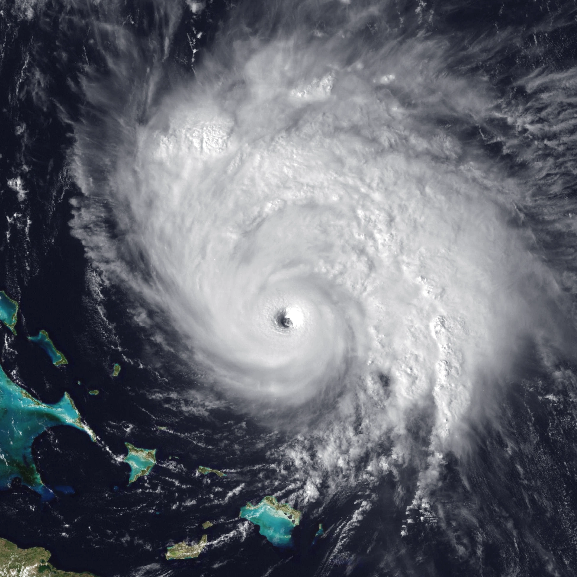
Hurricane Oscar[]
| Category 5 hurricane (SSHWS) | |
  | |
| Duration | August 29 – September 11 |
|---|---|
| Peak intensity | 180 mph (285 km/h) (1-min) 906 mbar (hPa) |
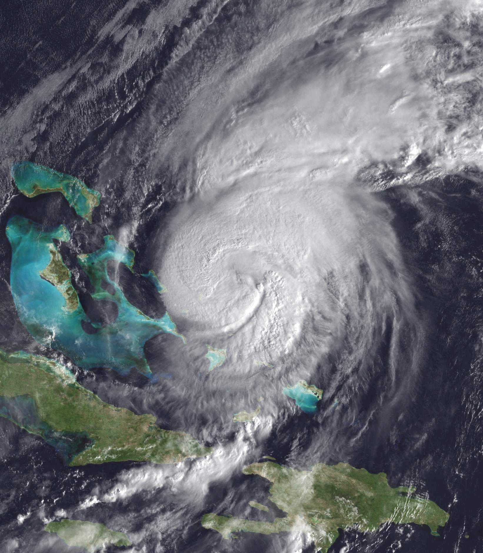
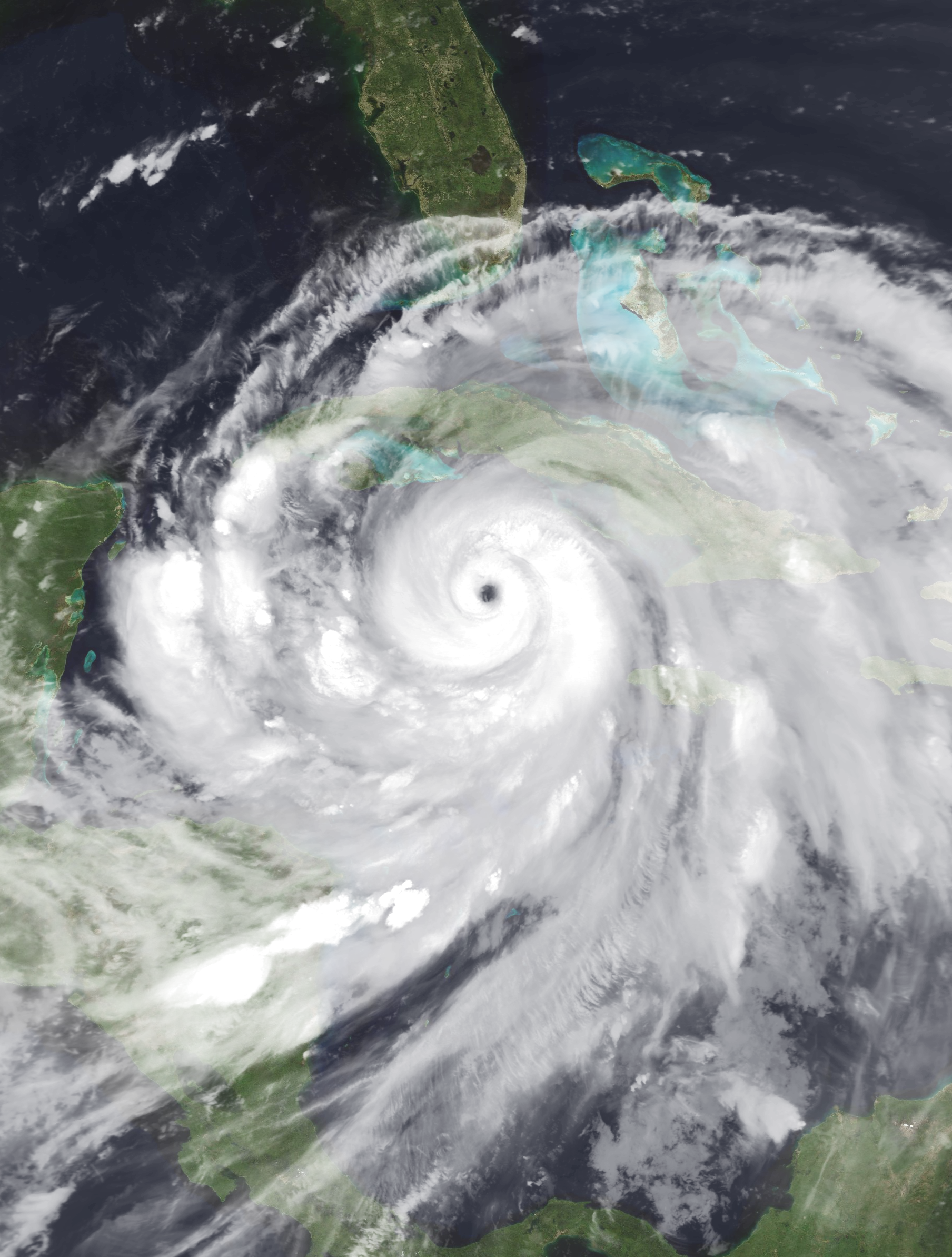
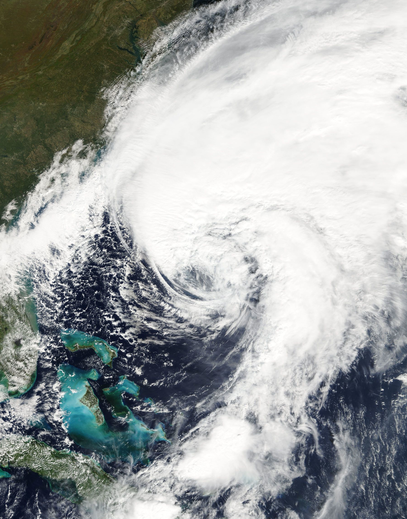
A tropical depression formed near east Nicaragua coast on August 29 and was upgraded to a tropical storm in late September 6. On September 7, the storm began intensifying rapidly, reaching Category 5 strength,the storm moved rapidly to the northeast at the time that it strengthened,making landfall on western Cuba on September 9 and later in Florida as a Category 4 storm. After crossing Florida, became extratropical.
At the storm precursor moved near Nicaragua and Costa Rica. Later,when it became a category 5 hurricane it was the strongest landfalling cyclone on record in the Atlantic when it crossed the western tip of Cuba and later Florida as a category 4 hurricane. Oscar resulted in at least 136 deaths, including 94 in the United States and 42 across the Caribbean and damages of 5500 million of dollars in loses.
Hurricane Patty[]
| Category 2 hurricane (SSHWS) | |
  | |
| Duration | September 2 – September 14 |
|---|---|
| Peak intensity | 110 mph (175 km/h) (1-min) 961 mbar (hPa) |
A vigorous tropical wave entered the Atlantic on August 24,travelling some days and developing into a tropical depression near Bahamas it moved northwest, becoming Tropical Storm Patty six hours after formation and further strengthening into a hurricane on September 5 and later in a category 2 hurricane.Increased shear caused the hurricane to rapidly weaken and transitioned into an extratropical cyclone.The extratropical low crossed the Atlantic and started to develop in the Mediterranean sea in a Medistorm.
Patty caused devastation, especially on Acklins, Crooked Island, Long Island, Rum Cay, and San Salvador Island.Severe storm surge inundated many communities, trapping hundreds of people in their homes.The storm brought strong winds to Bermuda that cut power to 15,000 customers.Deaths in total was six and damages nearly 1 billion,mostly in Europe for the extratropical and subtropical influence of this storm.
Hurricane Rafael[]
| Category 4 hurricane (SSHWS) | |
  | |
| Duration | September 9 – September 17 |
|---|---|
| Peak intensity | 140 mph (220 km/h) (1-min) 934 mbar (hPa) |
A tropical wave moved off the coast of Africa on September 9. A broad area of low pressure developed in a tropical storm at the time it passed southwest of Cape Verde. By 18:00 UTC on September 12. A more favorable environment allowed Rafael to attain hurricane intensity by 20:00 UTC on September 13,the system spined to a unusual east track and started a period of rapid intensification,reaching category 4 later on September 14. Progressively cooler waters and stronger shear caused Rafael to weaken to a tropical storm early on September 16, weaken to a tropical depression early on September 17, and degenerate into a remnant low at 18:00 UTC that day.The remnant low rapidily dissipated in Mali.
At the threat of the hurricane, all of Cape Verde was placed under a hurricane warning for the second time in history.Gale-force winds battered much of the Barlavento region through four days, downing numerous trees and utility poles.On the easternmost islands of Boa Vista and Sal,rainstorms damaged homes and roads, Swells from the hurricane produced violent seas along West African shores,destroying fishing villages and submerging large swaths of residential area in Senegal.But none deaths were directly attributed to Fred.
Hurricane Sara[]
| Category 1 hurricane (SSHWS) | |
  | |
| Duration | September 22 – September 29 |
|---|---|
| Peak intensity | 80 mph (130 km/h) (1-min) 984 mbar (hPa) |
A low developed from a tropical wave that moved off Africa on September 16. The wave pushed a unusually southwestern track,organizing into a tropical depression on September 23 and into Tropical Storm Sara twelve hours later and by 23:00 UTC,it made landfall over Colombia and turning to the west and stregtening over Panama and as a hurricane as it curved through north, the cyclone succumbed to an increasingly unfavorable regime and became an extratropical cyclone at the time it crossed Cuba.
The storm caused flooding as far south as Panama, where more than 300 fatalities occurred,Sara brought tropical storm winds to Jamaica,Colombia,Cuba and Bahamas several buildings were damaged.The storm caused a unknow number in losses and at least 564 people were left dead.
Tropical Storm Tony[]
| Tropical storm (SSHWS) | |
  | |
| Duration | October 1 – October 3 |
|---|---|
| Peak intensity | 45 mph (75 km/h) (1-min) 1004 mbar (hPa) |
A tropical wave moved off the coast of Africa on September 28 and was first monitored by the National Hurricane Center shortly afterwards. Development, however, was expected to be slow due to its low latitude and relatively fast motion. As it moved swiftly across the Main Development Region of the Atlantic Ocean,the disturbance began to gradually organize, The storm continued to organize as it accelerated towards Venezuela and Trinidad and Tobago throughout the night, with banding features becoming evident. Later on October 2, the system developed a closed low-level circulation and was upgraded to Tropical Storm Tony.One day later, at 21:00 UTC on October 3, the last advisory on Tony was issued following its degeneration into a tropical wave.
None deaths were reported. In Tobago, a man's house collapsed on him,resulting injuried.
Hurricane Valerie[]
| Category 3 hurricane (SSHWS) | |
  | |
| Duration | October 15 – October 21 |
|---|---|
| Peak intensity | 125 mph (205 km/h) (1-min) 972 mbar (hPa) |
On October 15,a broad area of low pressure formed in the central Atlantic Ocean.It moved steadily eastward and started to develop central convection. On October 15, the non-tropical low pressure system began to gain some tropical characteristics,the low transitioned into a subtropical storm and be classified as a tropical storm.
The storm's convection organized around a central core, and the system became a tropical storm on October 17 and received the name Valerie.An eye appeared near the storm's circulatory center,the system unespectly intensified into a hurricane first and later into a major hurricane.As Valerie accelerated to the northeast towards the Canary Islands, it slowly lost organization,Later it crossed Canary Islands Tropical Storm Valerie lost its tropical characteristics. The extratropical storm stayed two days with a excentric track and bringing intense winds and rains in Morroco.
On October 18 it merged with a frontal system northwest of the Canaries and became a vigorous extratropical storm. It caused severe damage in the Canary Islands and claimed at least seventeen lives,Valerie caused power outages, leaving some 200,000 people without power and forcing airports to close down.
The remnants of Valerie later moved offshore Morocco, bringing much rain and wind.It caused no significant damage.
Subtropical Storm William[]
| Tropical storm (SSHWS) | |
  | |
| Duration | November 13 – November 24 |
|---|---|
| Peak intensity | 70 mph (110 km/h) (1-min) 982 mbar (hPa) |
A low pressure gained subtropical characteristics. deep convection wrapped around a small circulation center that had developed within the larger cyclone. On November 13,it attained peak winds of 70 mph (110 km/h) and a minimum pressure of 982 mbar, It stayed some days as a subtropical,but unfavorable conditions weakened over increasingly colder waters and began merging with an approaching frontal boundary. Early on November 22. William transitioned into an extratropical cyclone and dissipating near Galicia.
William remnants make landfall in Spain and Portugal.Only three injuries were reported,aside from flooding in some areas.
Storm Names[]
The following names were used for named storms in the North Atlantic in 2018. The names not retired from this list will be used again in the 2024 season. This is the same list used in the 2012 season. The name Sara was used for Atlantic storms for the first time in 2018.
|
|
|
Season Effects[]
| Storm name |
Dates active | Storm category at peak intensity |
Max 1-min wind mph (km/h) |
Min. press. (mbar) |
Areas affected | Damage (USD) |
Deaths | |||
|---|---|---|---|---|---|---|---|---|---|---|
| Alberto | May 2 – May 4 | Category 4 hurricane | 145 | 928 | Guyana, Brazil | 150 | 18 | |||
| Two | May 19 – May 20 | Tropical depression | 30 | 1012 | Bahamas | Minimal | None | |||
| Beryl | May 31 – June 4 | Tropical storm | 65 | 992 | Southern United States | 120 | 28 | |||
| Chris | June 8 – June 14 | Category 2 hurricane | 105 | 968 | Mexico, El Salvador, Nicaragua, Cuba, Southeastern United States | 1030 | 118 | |||
| Debby | June 12 – June 20 | Category 1 hurricane | 80 | 992 | Northeastern United States, Great Lakes, Canada | TBD | 12 | |||
| Ernesto | June 23 – June 26 | Category 2 hurricane | 105 | 971 | None | None | None | |||
| Florence | July 2 – July 5 | Tropical storm | 45 | 1001 | Yucatan Peninsula, Central Mexico | 65 | 3 | |||
| Gordon | July 4 – July 14 | Category 4 hurricane | 140 | 937 | Bahamas, East Coast of the United States | Minimal | None | |||
| Helene | July 9 – July 16 | Category 3 hurricane | 120 | 949 | Dominican Republic, Cuba, Northeastern United States, Canada | 16075 | 251 | |||
| Isaac | July 13 – August 1 | Category 5 hurricane | 160 | 919 | Leeward Islands, United States, Mexico, Nicaragua | 30400 | 1200 | |||
| Joyce | July 23 – August 4 | Tropical storm | 45 | 981 | Bahamas, East Coast of the United States, Canada | 300 | None | |||
| Kirk | August 7 – August 14 | Category 2 hurricane | 95 | 972 | Senegal, Cape Verde, Azores | TBD | TBD | |||
| Leslie | August 9 – August 16 | Category 1 hurricane | 80 | 962 | Azores, Spain, France | 1000 | 7 | |||
| Michael | August 14 – August 20 | Category 1 hurricane | 75 | 982 | Dominican Republic, Haiti | 1500 | 1590 | |||
| Nadine | August 18 – August 27 | Category 2 hurricane | 105 | 956 | Southeastern United States (Florida), Mid-Atlantic States | 483.5 | 11 | |||
| Oscar | August 28 – September 8 | Category 5 hurricane | 180 | 906 | Nicaragua, Costa Rica, Cuba, Bahamas, Southeastern United States (Florida) | 5500 | 136 | |||
| Patty | September 2 – September 14 | Category 2 hurricane | 110 | 961 | Bahamas, Azores, Spain, France, Italy, Greece, Libya, Croatia | 990 | 6 | |||
| Rafael | September 9 – September 16 | Category 4 hurricane | 140 | 934 | Senegal, Cape Verde, Mali | TBD | TBD | |||
| Sara | September 22 – September 29 | Category 1 hurricane | 80 | 984 | Colombia, Panama, Jamaica, Cuba, Bahamas | TBD | 564 | |||
| Tony | October 1 – October 3 | Tropical storm | 45 | 1004 | Guyana, Colombia, Venezuela | TBD | TBD | |||
| Valerie | October 15 – October 21 | Category 3 hurricane | 125 | 972 | Canary Islands, Madeira, Morocco, Western Sahara | 500 | 17 | |||
| William | November 13 – November 24 | Tropical storm | 70 | 982 | Portugal, Spain | TBD | 3 | |||
| Season aggregates | ||||||||||
| 21 systems | July 21 – December 4 | 180 | 908 | TBD | >5,000 | |||||