Based off of this I made less than a year ago: [1]
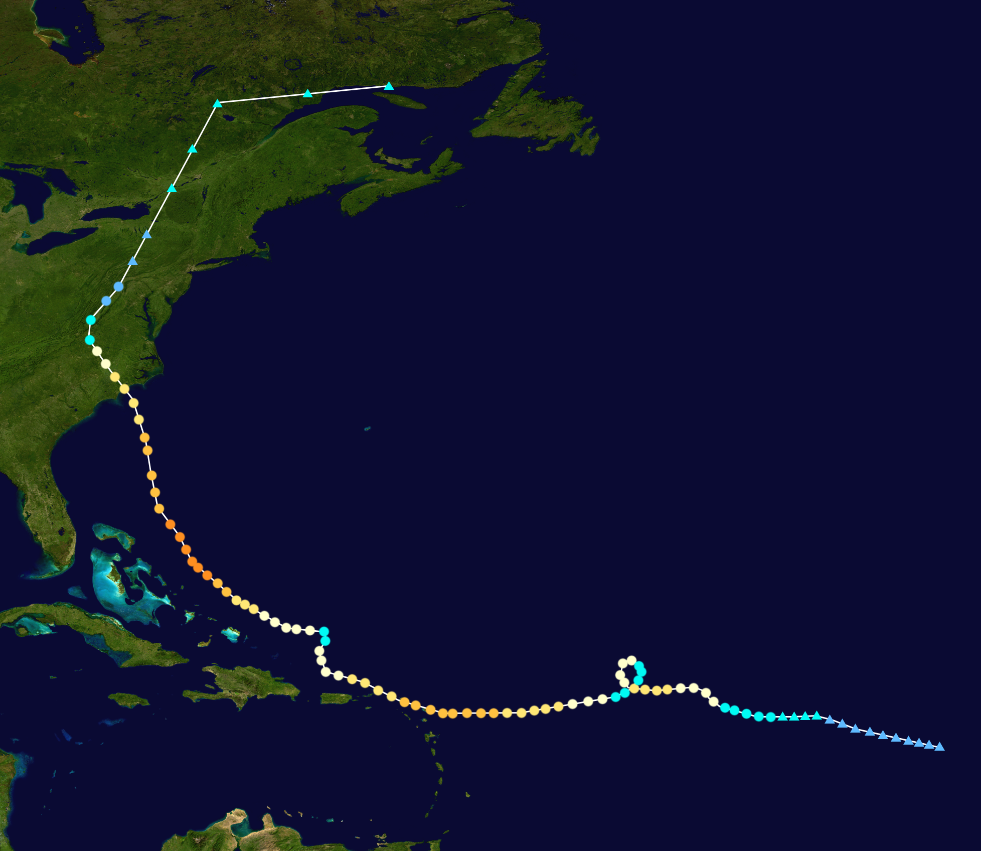
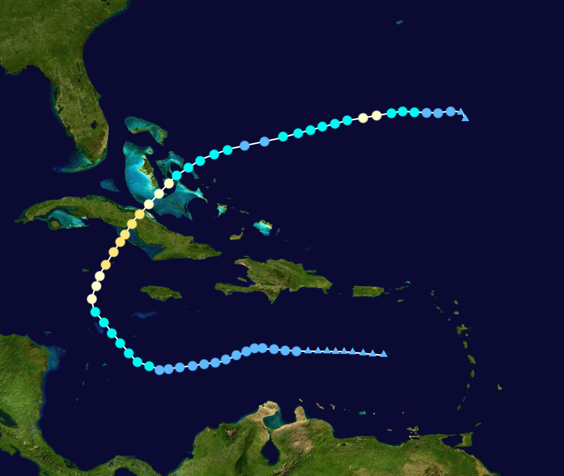
The 2020 Atlantic hurricane season was a hyperactive season that was the third-costliest season on record, with a damage total of $309.11 billion (USD), only behind the 2023 and 2027 seasons, and the second-deadliest Atlantic hurricane season on record, with a death toll more than 23 thousand, only behind 1780. With 17 named storms, 12 hurricanes, and 6 major hurricanes forming this year, the 2020 season ties both the 2017 and the 1936 as the fifth-most active season. This season was the last of the string of 5 consecutive above-average seasons starting from 2016. The season officially started on June 1 and ended on November 30, although storms may form at any time of the year.
The first storm, Arthur, formed on June 9 and struck both the Yucatan Peninsula and Texas before dissipating on June 15. Bertha was the third longest-lived hurricane in the Atlantic, and caused damage in the Lesser Antilles and the Carolinas. Dolly made landfall in Cuba on mid-July, causing some damage there. Edouard also made landfall in the Florida Panhandle at that same time period. Hanna made landfall in Florida, before being downgraded to a remnant low and then regenerating and becoming a hurricane. It then made landfall in Newfoundland. Isaias struck the Yucatan Peninsula as a Category 4 hurricane and then entered into the Gulf of Mexico before making striking the state of Louisiana in early September. The most catastrophic tropical cyclone that makes up most of the season’s deaths and damages was Kyle, which struck Puerto Rico as a Category 5 hurricane, overall the second one to do so, curved to the left and then struck New York in late September-early October. Kyle was the costliest hurricane on record at that time, surpassing both Harvey and Katrina, and the second-deadliest on record, only supassed by the Great Hurricane of 1780. Marco struck Florida as a tropical storm, peaked as a Category 3 hurricane in the Gulf of Mexico, and then made landfall in Mexico at that category before crossing into the Pacific Ocean. Marco was the first hurricane to cross from the Atlantic to the Pacific since Otto in 2016. Paulette formed as a typical post-season storm, striking the Iberian Peninsula as a weak post-tropical system in early December. Rene, a very extreme Category 4 December hurricane, was the strongest off-season storm in the Atlantic. Very unusually warm waters contributed to the storm, causing it to rapidly intensify into a Category 4 hurricane. It made landfall in the Carolinas at that category at Christmas Day, causing a lot of deaths there. Rene became a remnant low on December 27, marking the end of the season.
Forecasters who are planning ahead for the season, called for a slightly above-average season with the anticipation development of a weak La Niña. However, the La Niña continued to grow until it peaked at the month of August overall becoming a average La Niña. After that it started to slowly die out, the La Niña dissipating by the start of 2021. Therefore, the activity of this season exceeded most of their expectations.
Season summary[]

Systems[]
|
Tropical Storm Arthur[]
| Tropical storm (NHC) | |
  | |
| Duration | June 9 – June 16 |
|---|---|
| Peak intensity | 60 mph (95 km/h) (1-min) 994 mbar (hPa) |
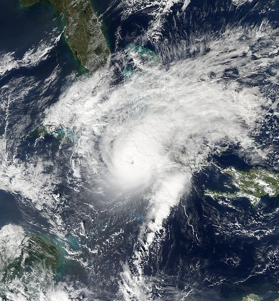
An area of low pressure formed on June 4, drifting through the Caribbean Sea. It gradually organized due to the warm waters there. The NHC began tracking it on June 7, giving it a medium chance of forming. A couple of days later at 00:00 UTC on July 9, it eventually developed into Tropical Depression One, the first system of the season. It then drifted northwest, heading into the Yucatan Peninsula. On June 11 03:00 UTC, it made landfall while still being a tropical depression. Despite the landfall, it weakened only slightly, not degenerating into a remnant low. On June 12 at 00:00 UTC, it entered the Gulf of Mexico and then started gradually intensifying. On June 13 at 06:00 UTC, it strengthened into a tropical storm, earning the name Arthur. It headed west-northwest to the state of Texas. It eventually reached its peak intensity on the 14th at 18:00 UTC, 12 hours before its landfall. It had winds up to 60 mph (95 km/h) and a minimum pressure of 994 mbar. At the time of its landfall, it started to demise gradually, becoming a tropical depression at 00:00 UTC on June 16. It then degenerated into a remnant low later that day, getting as far as Kentucky before it dissipated.
In total, Arthur caused $188 million in damages and 3 deaths indirect and direct.
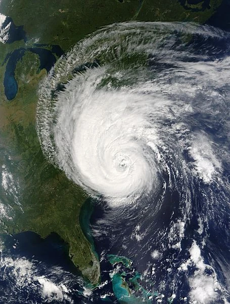
Hurricane Bertha[]
| Category 4 hurricane (NHC) | |
  | |
| Duration | June 28 – July 20 |
|---|---|
| Peak intensity | 140 mph (220 km/h) (1-min) 938 mbar (hPa) |
- Main articles: Hurricane Bertha (Sandy156) and Hurricane Bertha
A tropical wave emerged off the coast of Africa on June 20, slowly drifting west while gradually organizing over warm waters. On June 24, it was finally recognized by the NHC and on June 26 at 18:00 UTC, the agency gives it a 90% chance of forming in the next 48 hours. It had tropical storm strength six hours later and at 00:00 UTC on June 28, it was finally a tropical storm, the NHC naming it Bertha. It then intensified a little quickly and on June 30 at 06:00 UTC, it was upgraded to a hurricane and exactly one day later, strengthened into a Category 2 hurricane. It reached its first initial peak intensity on July 1 at 12:00 UTC, with 100 mph (160 km/h) winds and a pressure of 978 mbar. Due to it moving into a small area of wind shear, it abated slightly gradually, falling back to a Category 1 on July 2 06:00 UTC and then a tropical storm the next day, as it made a small loop around. Once it fully completed its loop, it exited the area of wind shear, and started gradually intensifying again. On July 4 at 12:00 UTC, it intensified back into a Category 1 hurricane and 18 hours later, strengthened into a Category 2. On July 7 at 12:00 UTC, it further intensified into a major hurricane, reaching its second initial peak intensity another 18 hours later, with winds up to 120 mph (190 km/h) and a minimum pressure of 960 mbar. During the period of July 8, 18:00 UTC to July 9, 12:00 UTC, Bertha then impacted some islands in the Lesser Antilles, hitting the islands of Barbuda, Saint Barthélemy, Saint Martin/Sint Maarten, and Anguilla respectively. At the same time, it also underwent an eyewall replacement cycle, causing it to start weakening. It fell below major hurricane strength on July 9, 12:00 UTC and weakened to a Category 1 24 hours later. It took a turn to the north and then further diminished into a tropical storm on July 11 at 12:00 UTC, where it held that strength for 12 hours before intensifying back into a hurricane. That same time, it then took a sharp turn to the west. On July 12 at 18:00 UTC, the hurricane unexpectedly rapidly intensified, reaching major hurricane strength on July 14, 06:00 UTC and then a Category 4 12 hours later. It reached its peak intensity on July 15, 06:00 UTC, with maximum winds of 140 mph (220 km/h) and a minimum central pressure of 938 mbar (hPa). After that, it began another eyewall replacement cycle, again diminishing the hurricane as it approached the Carolinas. It weakened to a Category 3 on July 16, 06:00 UTC and then fell below major hurricane on July 17, 12:00 UTC. Bertha made its landfall in southern North Carolina on July 18 at 00:00 UTC. It quickly abated over land, weakening to a tropical storm on July 19, 00:00 UTC and then to a tropical depression 12 hours later. It then became a remnant low on July 20, reaching Canada quickly as it attained tropical storm force winds.
Bertha caused $11.72 billion in damages and 75 deaths (68 direct and 7 indirect) in total.
Hurricane Cristobal[]
| Category 1 hurricane (NHC) | |
  | |
| Duration | July 4 – July 8 |
|---|---|
| Peak intensity | 85 mph (140 km/h) (1-min) 986 mbar (hPa) |
In late June, the NHC began monitoring an area in the open Atlantic for tropical or subtropical development within the next several days. It drifted northwest for several days while very gradually organizing. The NHC gives it a 90-100% chance of forming in the next few days. It quickly attained tropical storm strength on July 4, 00:00 UTC. It then fully acquired subtropical characteristics, thus it was developed into Subtropical Storm Cristobal at 18:00 UTC that day. For 30 hours, it stayed subtropical, slowly transitioning into a tropical storm. Cristobal then became fully tropical on July 6, 00:00 UTC. At 18:00 UTC, it eventually became a hurricane and on July 7, 06:00 UTC, reached its peak intensity with sustained winds of 85 mph (140 km/h) and a minimum pressure of 986 mbar (hPa). Entering very cold waters, it weakened to a tropical storm on July 8, 06:00 UTC and then transitioning into a extratropical cyclone 12 hours later.
Hurricane Dolly[]
| Category 2 hurricane (NHC) | |
  | |
| Duration | July 14 – July 27 |
|---|---|
| Peak intensity | 100 mph (155 km/h) (1-min) 984 mbar (hPa) |
- Main articles: Hurricane Dolly (2020-Sandy156) and Hurricane Dolly (2020)
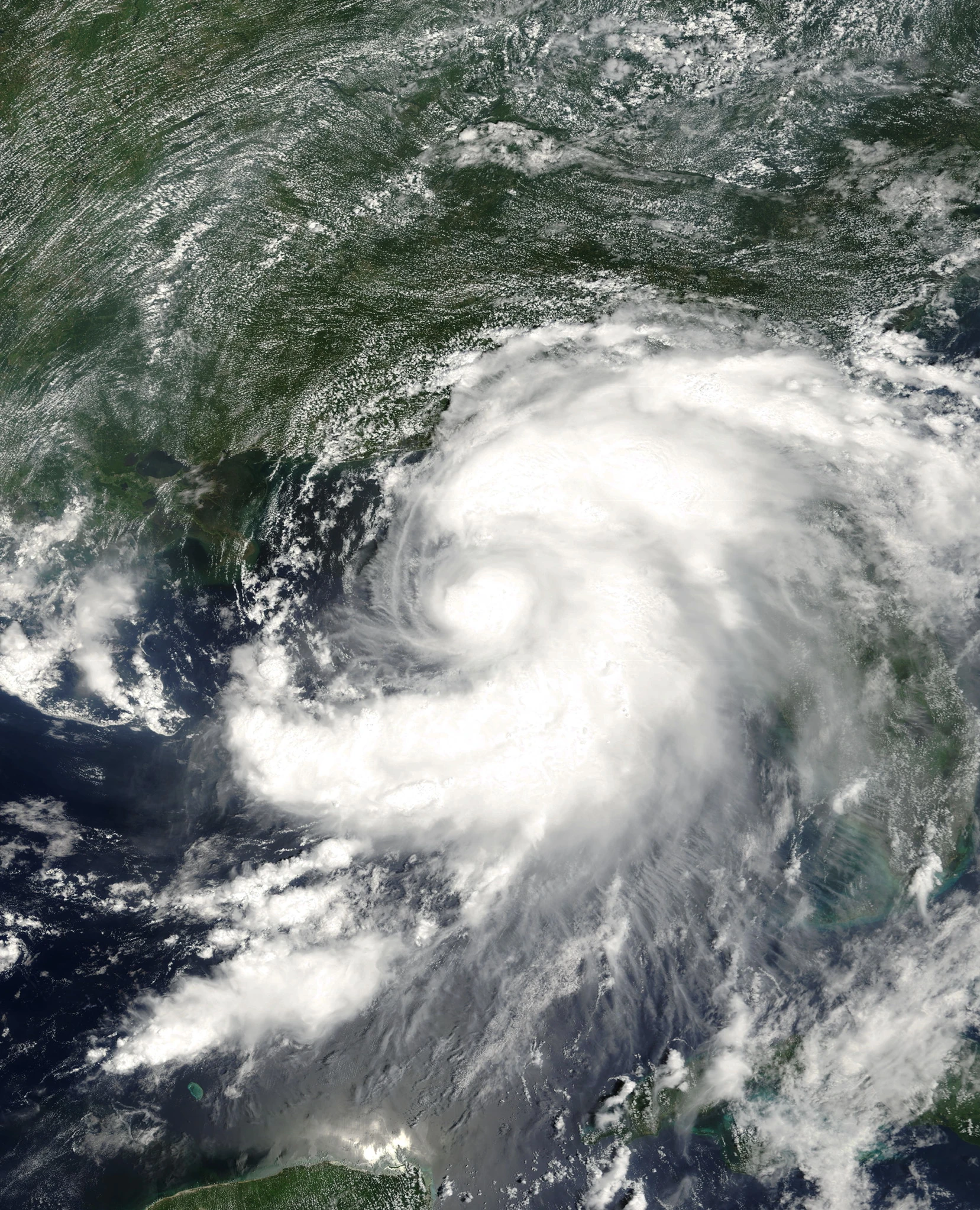
In early July, a tropical wave emerged off the coast of Africa. For several days, it advanced westward for several days, no change in organization. 2 days after it entered the Caribbean Sea, the NHC tracked it, giving it a 0/0% chance of forming. It drifted slowly in the Caribbean, very gradually organizing. Finally, on July 14 at 12:00 UTC, it developed into Tropical Depression Four. Due to increasing wind shear, the system struggled to strengthen for a few days, trying to maintain being a tropical depression. On July 17, the wind shear started to subside, the system now able to intensify. On July 18, 00:00 UTC, the depression finally became a tropical storm, named Dolly. It turned northwest, gradually intensifying as the wind shear completely impacted the storm no more. It then strengthened more rapidly and on July 19, 12:00 UTC, it became a hurricane. The hurricane now turned north-northeast right toward Cuba after it was upgraded to a hurricane. It became a Category 2 hurricane on July 20, 06:00 UTC, and reached its peak intensity 12 hours later right before landfall. It had maximum winds of 100 mph (155 km/h) and a minimum pressure of 984 mbar (hPa) at the time of its peak. 12 hours later, on July 21, 06:00 UTC, Dolly made landfall in the southern province of Ciego de Ávila. Intensity decreased slightly between its peak intensity and landfall, with 5 mph (10 km/h) decrease in wind speed and 3 mbar (hPa) increase in pressure. However, it remained a Category 2 until it exited Cuba, on July 21 at 15:00 UTC, where it weakened back to a Category 1. For the period of July 21, 18:00 UTC to the next day at 18:00 UTC, it then impacted the Bahamas, falling below hurricane strength on July 22, 12:00 UTC. Once it exited the Bahamas, however, it continued to abate, weakening to a tropical depression on July 23, 18:00 UTC. 12 hours later, it became a tropical storm again, while gradually intensifying abruptly. It strengthened into a hurricane on July 25 at 18:00 UTC and then reached its secondary peak intensity 6 hours later, with winds up to 80 mph (130 km/h) and a minimum pressure of 989 mbar. After that, due to increasing wind shear, it started to diminish. It weakened back to a tropical storm on July 26, 06:00 UTC, and then to a tropical depression again on July 27, 00:00 UTC. It eventually became a remnant low at 18:00 UTC that day, which dissipated the next day.
Dolly caused $458 million of damages and killed 18 people direct and indirect in Cuba and Bermuda.
Tropical Storm Edouard[]
| Tropical storm (NHC) | |
  | |
| Duration | July 19 – July 22 |
|---|---|
| Peak intensity | 50 mph (85 km/h) (1-min) 997 mbar (hPa) |
An area of low pressure formed in the Gulf of Mexico on July 16, the NHC monitoring it. The system was in warm waters with no wind shear, causing it to organize. On July 19 at 12:00 UTC, it developed into Tropical Depression Five, the system continuing to intensify. Later, on July 20 06:00 UTC, it strengthened into Tropical Storm Edouard. After that, it turned towards the north, heading straight to the Florida Panhandle. 12 hours later, it reached its peak intensity, with 50 mph (85 km/h) winds and a minimum pressure of 997 mbar. Due to land interaction, it weakened slightly, winds dropped 5 mph (10 km/h) and the pressure upped to 999 mbar at the time of its landfall in the Florida Panhandle on July 21, 12:00 UTC. It started to abate, falling into a tropical depression 6 hours later and then into a remnant low on July 22, 06:00 UTC.
Edouard caused $84 million of damages and 2 fatalities in the Southeastern U.S.
Tropical Depression Six[]
| Tropical depression (NHC) | |
  | |
| Duration | July 30 – July 31 |
|---|---|
| Peak intensity | 35 mph (55 km/h) (1-min) 1004 mbar (hPa) |
An area of low pressure formed on July 27, 250 mi (400 km) northwest of Bermuda. It organized gradually, despite entering cooler waters. On July 30, 06:00 UTC, it was classified as a tropical depression. The system saw little to no chance in strength during its lifetime and On July 31, 12:00 UTC, it became a remnant low and 12 hours later, it dissipated.
Hurricane Fay[]
| Category 3 hurricane (NHC) | |
  | |
| Duration | August 3 – August 12 |
|---|---|
| Peak intensity | 120 mph (195 km/h) (1-min) 971 mbar (hPa) |
A tropical wave emerged off the coast of Africa on July 26. It passed over Cape Verde and then moved into the open Atlantic, where it started to gradually organize due to warmer waters and low to no wind shear. It was recognized by the NHC on July 30, giving it a 0% chance of forming in the next 48 hours. On August 2, it quickly organized as it attained tropical storm force winds. On August 3, 06:00 UTC, it developed into Tropical Storm Fay, heading northwest. It then took a curve to the west, gradually intensifying over warm waters. On August 5, 12:00 UTC, it suddenly rapidly intensified, going from a tropical storm to a Category 3 major hurricane in a period of 24 hours from August 5, 18:00 UTC, to August 6, 18:00 UTC. It reached its peak intensity at 06:00 UTC the next day, with winds up to 120 mph (195 km/h) and a minimum pressure of 971 mbar (hPa). Then, an eyewall replacement cycle undergoes for this hurricane, diminishing it to a Category 2 on August 8, 00:00 UTC, and then to a Category 1 on August 9, 06:00 UTC. The hurricane now enters cooler waters, further weakening below hurricane strength briefly on August 10, 06:00 UTC, before it became a hurricane again 6 hours later. Waters are getting cooler for the system and on August 11, 00:00 UTC, it weakened back to a tropical storm, starting to transition into a extratropical cyclone. On August 12 at 06:00 UTC, it eventually became fully extratropical, heading northwest to Great Britain. While it’s at its approach, it attained hurricane force winds for 30 hours before weakening back to tropical storm strength. It hit Ireland on the morning of August 14 and then Great Britain that afternoon.
Tropical Storm Gonzalo[]
| Tropical storm (NHC) | |
  | |
| Duration | August 11 – August 14 |
|---|---|
| Peak intensity | 40 mph (65 km/h) (1-min) 1001 mbar (hPa) |
An area of low pressure formed in the open Atlantic on August 5. It drifted west, interacting a little with Hurricane Fay, which was about 300 miles away. After it’s done interacting, the NHC began tracking it, giving it a low chance of forming, while the system gradually organized due to warm waters. On August 11 at 18:00 UTC, it developed into Tropical Depression Eight, now gradually intensifying. On August 13, 00:00 UTC, it strengthened into a tropical storm, named Gonzalo by the NHC. It reached its peak intensity that time, with 40 mph (65 km/h) winds and a pressure of 1001 mbar (hPa). Wind shear started to increase, causing it to diminish. It weakened to a tropical depression at 12:00 UTC that day and then on August 14, 12:00 UTC, it was downgraded to a remnant low.
Hurricane Hanna[]
| Category 1 hurricane (NHC) | |
  | |
| Duration | August 12 – August 23 |
|---|---|
| Peak intensity | 80 mph (130 km/h) (1-min) 989 mbar (hPa) |
- Main articles: Hurricane Hanna (2020-Sandy156) and Hurricane Hanna (2020)
A tropical low formed on August 6, in the Caribbean Sea. It headed northwest, slammed into the Yucatan Peninsula, and then entered the Gulf of Mexico a few days later. It turned right toward the state of Florida and then started to organize. On August 12, 12:00 UTC, it was designated as Tropical Depression Nine. Then on August 13, 12:00 UTC, it intensified into Tropical Storm Hanna, about 1,000 mi (1,600 km) west of Florida. It reached its initial peak intensity 6 hours later, with winds of 45 mph (70 km/h) and a minimum pressure of 998 mbar. It struck Florida at its initial peak intensity at 21:00 UTC that day, its landfall diminishing the storm into a tropical depression on August 14, 00:00 UTC and then a remnant low at 12:00 that same day.
The remnant low drifted for several days, with no change in organization due to dry weather and wind shear. Finally, late on August 18, it was better organized due to improved conditions and was redeveloped into a subtropical depression. On August 20, 00:00 UTC it intensified into a subtropical storm, while it was on the verge to becoming fully tropical. Eventually, at 18:00 that day, it fully transitioned into a tropical storm, turning toward the northeast. On August 22 at 00:00 UTC, it strengthened into a hurricane, despite the cooler waters there. Six hours later, it reached its peak intensity, with maximum winds of 80 mph (130 km/h) and a minimum pressure of 989 mbar (hPa). Decreasing water temperature weakened the system, becoming a tropical storm again at 18:00 UTC that day. Early on August 23, it struck Newfoundland with winds up to 60 mph (95 km/h) and a minimum pressure of 994 mbar (hPa). 6 hours later, it transitioned into a extratropical cyclone, still over the island.
Hanna, in total, caused $210 million (USD) in damages and caused 6 deaths indirect and direct. 4 deaths were reported in Florida and 2 more were reported in Newfoundland.
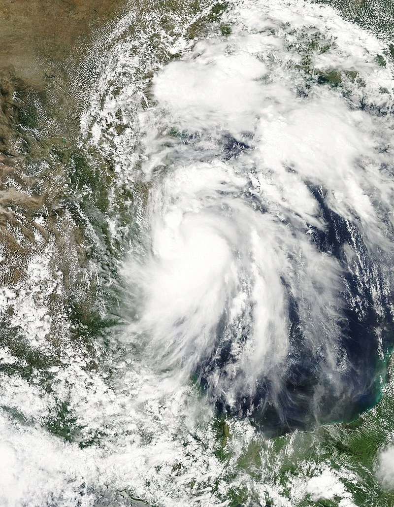
Hurricane Isaias[]
| Category 4 hurricane (NHC) | |
  | |
| Duration | September 1 – September 13 |
|---|---|
| Peak intensity | 150 mph (240 km/h) (1-min) 934 mbar (hPa) |
- Main article: Hurricane Isaias
On August 26, a tropical low formed in the eastern verge of the Caribbean Sea. It drifted westward over warm waters, very slowly organizing. It was tracked by the NHC on August 28, giving it a low chance of forming. On August 31, it was designated as Potential Tropical Cyclone Ten, attaining tropical storm force winds at 18:00 UTC that day. Hurricane and Tropical Storm Watches were put into effect ahead of the storm. On September 1 at 06:00 UTC, it developed into Tropical Storm Isaias, about 1750 mi (2820 km) northeast from De Caratasca Lagoon at the country of Honduras, heading west to the Yucatan Peninsula. A while later, it then suddenly started rapidly intensifying in very favorable conditions, becoming a hurricane on September 2, 06:00 UTC, and then jumped straight into a Category 4 major hurricane 12 hours later. Later on, it reached its peak intensity on September 3 at 00:00 UTC, with maximum winds of 150 mph (240 km/h) and a minimum pressure of 934 mbar (hPa). Due to its approach to land, it weakened slightly. It made landfall in Belize technically 2 times, one in a peninsula near San Pedro at 12:00 UTC that day, and another in mainland Belize 6 hours later, with maximum winds of 145 mph (235 km/h) and a minimum pressure of 939 mbar (hPa). It rapidly weakened during its landfall, falling below major hurricane strength on September 4, 06:00 UTC, and below hurricane strength six hours later. Even though it entered waters in the Gulf of Mexico at 21:00 UTC that day, it still abated, becoming a tropical depression on September 5, 06:00 UTC. Once it stopped impacting the area, it allowed itself to continuing to intensify, becoming a tropical storm at 1800 UTC and a hurricane again the next day. It turned to the east, briefly holding Category 2 strength on September 7, 1800 UTC. Unexpectedly, a high-pressure area quickly formed to the northeast of the hurricane that was going southeast, weakening the hurricane to a tropical storm and looping it to the northwest. Once the high-pressure area stopped interacting with the storm, it began to strengthen once more, becoming a hurricane again late on September 9, and then a Category 2 hurricane on September 10, 1200 UTC. It eventually reached its secondary peak intensity on September 11 at 0000 UTC, with maximum sustained winds of 110 mph (180 km/h) and a minimum central pressure of 965 mbar (hPa). Six hours later, it made landfall in Louisiana, quickly diminishing over land. It fell below hurricane strength just twelve hours after landfall and then tropical storm strength on September 12, 0600 UTC. It then degenerated into a low pressure area early on September 13, over Arkansas at the time.
Tropical Depression Eleven[]
| Tropical depression (NHC) | |
  | |
| Duration | September 6 – September 8 |
|---|---|
| Peak intensity | 35 mph (55 km/h) (1-min) 1002 mbar (hPa) |
A low pressure area formed on September 2 and it gradually organized in the warm waters. It developed into Tropical Depression Eleven on September 6, 06:00 UTC. Increasing wind shear made the system stall in intensification. Therefore, it reached its peak intensity at 18:00 UTC with 35 mph (55 km/h) maximum winds and 1002 mbar (hPa) minimum pressure. The system started to weaken with its wind shear. It dissipated on September 8 at 06:00 UTC.
Hurricane Josephine[]
| Category 1 hurricane (NHC) | |
  | |
| Duration | September 8 – September 13 |
|---|---|
| Peak intensity | 85 mph (140 km/h) (1-min) 985 mbar (hPa) |
A tropical low formed on September 5, gathering organization as it headed west. On September 8 at 00:00 UTC, it developed into Tropical Depression Twelve. It steadily intensified due to warm waters and low wind shear, becoming a tropical storm named Josephine by the NHC on September 9, 12:00 UTC. It became a hurricane on early September 11, reaching peak intensity at 18:00 UTC that day, with winds up to 85 mph (140 km/h) and a minimum pressure of 985 mbar (hPa). Due to increasing wind shear, the system weakened, down to a tropical storm on September 12, 12:00 UTC and then to a tropical depression 24 hours later. It eventually dissipated late on September 13.
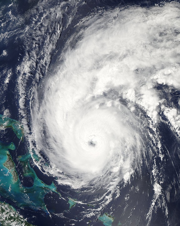
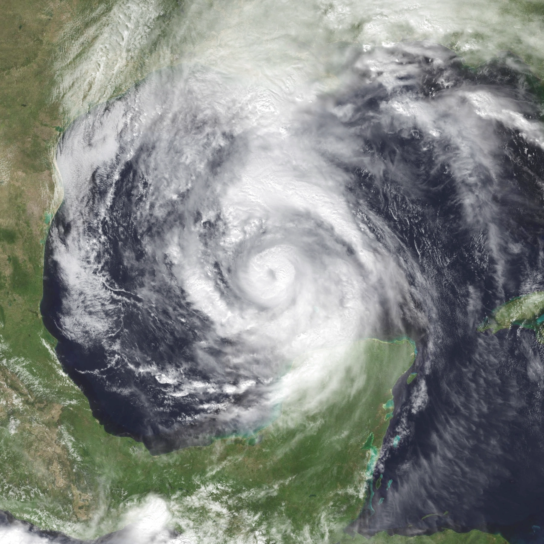
Hurricane Kyle[]
| Category 5 hurricane (NHC) | |
  | |
| Duration | September 19 – October 9 |
|---|---|
| Peak intensity | 175 mph (280 km/h) (1-min) 903 mbar (hPa) |
- Main articles: Hurricane Kyle (Sandy156) and Hurricane Kyle
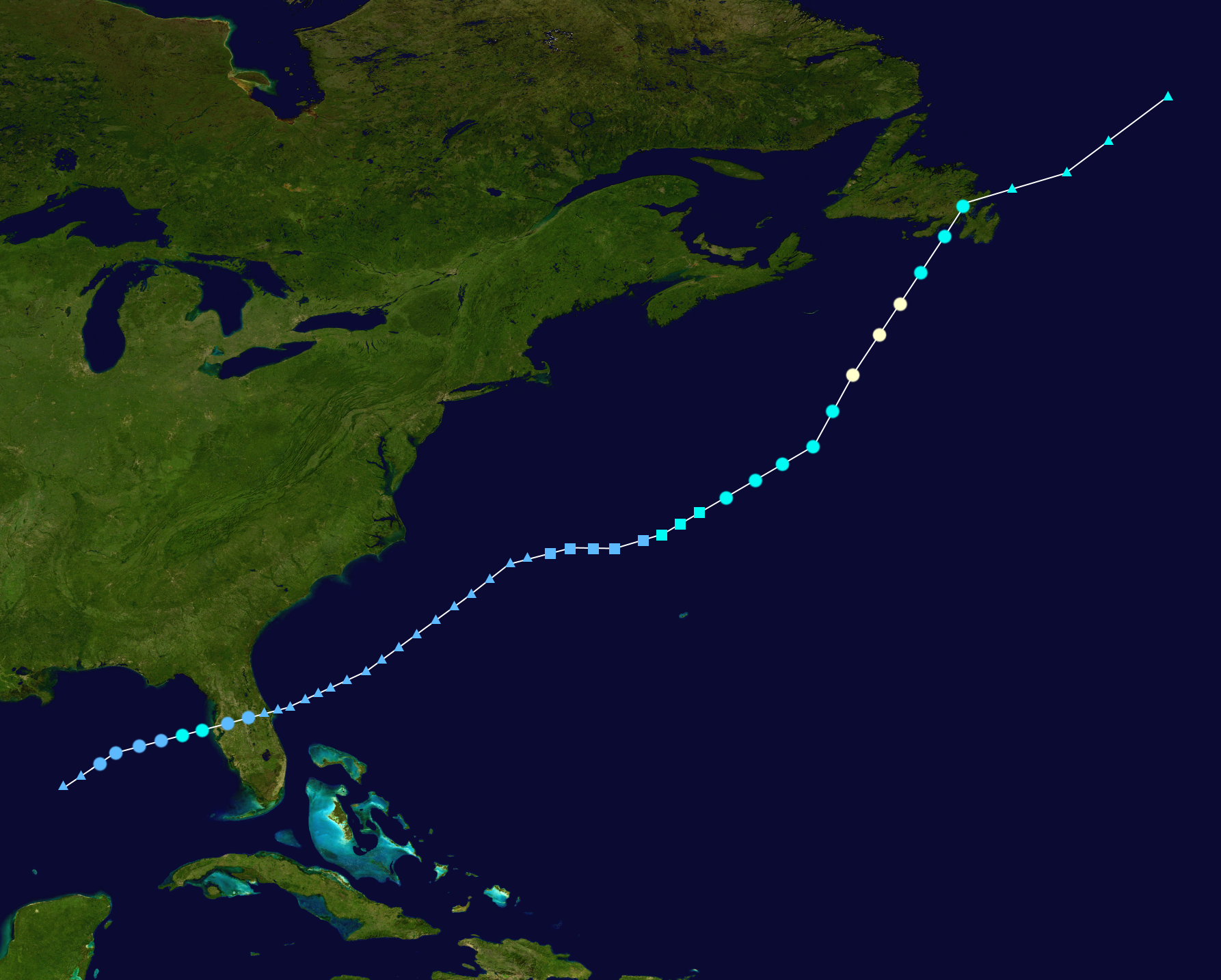
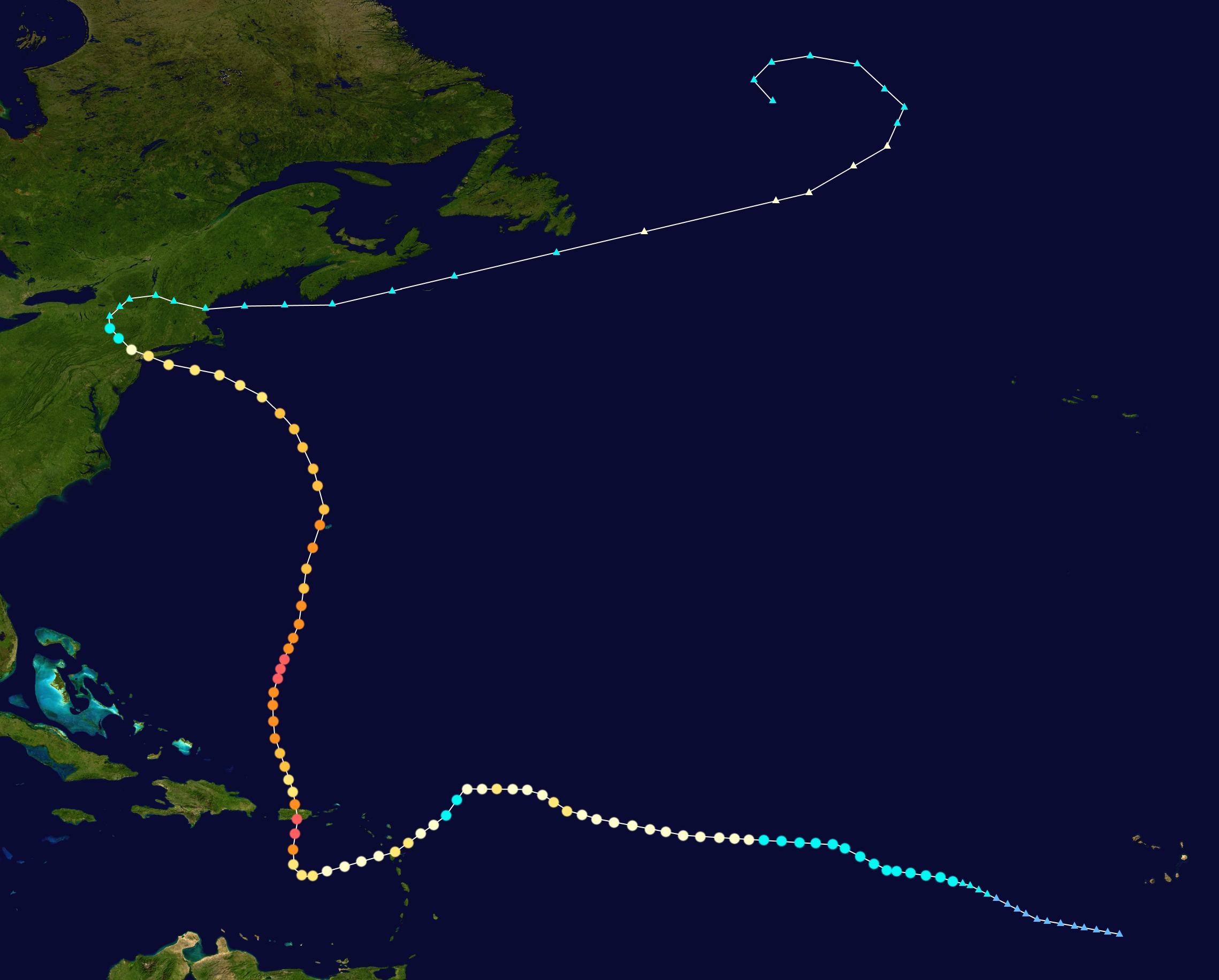
On September 12, a tropical wave emerged off of the coast of Africa. For a few days, it drifted westward, with no change in organization. On September 16, it started to organize, the NHC now tracking the system. Then on September 18 at 18:00 UTC, it attained tropical storm force winds. Eventually, it developed into a tropical storm, named Kyle by the NHC, on September 19 at 12:00 UTC. Moving westward gradually intensifying, Kyle was in warm waters with low wind shear. Finally on September 23 at 00:00 UTC, Kyle strengthened into a hurricane, three and a half days after it developed. Kyle didn’t strengthen further into a Category 2 hurricane until September 25 at 18:00 UTC when it attained 100 mph (160 km/h). From there on until September 31, it kept on influencing between a Category 1 and 2, with the exception of weakening to a tropical storm on late September 27, while it took a sharp turn southwest. At the third time of strengthening into a Category 2, it was approaching the island of Guadeloupe, which is in the Lesser Antilles. It hit the island on September 29 at 00:00 UTC, with sustained winds of 105 mph (170 km/h) and a minimum central pressure of 970 mbar. After it hit the island, it immediately weakened to a Category 1, six hours later. The hurricane strengthened back to a Category 2 hurricane on September 30, 06:00 UTC. 6 hours later, it unexpectedly started rapidly intensifying, jumping from a Category 2 to a Category 5 hurricane in a margin of 12 hours. It reached its peak intensity on September 31 at 06:00 UTC, with sustained winds up to 175 mph (280 km/h) and a minimum central pressure of 903 mbar (hPa). Six hours later, Kyle made landfall in southern Puerto Rico, just 10 mi (16 km) west of the city of Salinas. The hurricane weakened inland, becoming a Category 4 once it exited the island. Still, it diminished in the ocean as it still interacted with land, weakening to a Category 2 hurricane on October 1, 00:00 UTC. Once it stopped interacting, it started to intensify again due to favorable conditions, becoming a major hurricane at 12:00 that day, a Category 4 early the next day, and then to a Category 5 on October 3 at 00:00 UTC. It eventually reached its secondary peak intensity at 06:00 that day, with winds up to 160 mph (260 km/h) and a minimum pressure of 917 mbar (hPa). Due to a decrease in water temperature, Kyle started gradually weakening, down to a Category 4 hurricane at 18:00 UTC the same day and then to a Category 3 an exact day later. It then abruptly intensified back to a Category 4 on October 5, 06:00 UTC, despite cooler waters. It then made its closest approach to the island of Bermuda 6 hours later, roughly 50 mi (80 km/h) from it. At 18:00 UTC, Kyle weakened to a Category 3, just as it started interacting with a nearby cold-core low, turning it toward the northwest. Early on October 7, the hurricane weakened below major hurricane strength, just as it was heading toward New York. Eventually, on October 9 at 12:00 UTC, Kyle made landfall in western Long Island, with maximum winds up to 100 mph (160 km/h) and a minimum central pressure of 963 mbar. The hurricane then went over New York City as it was rapidly weakening over land. It then finally became non-tropical, turning east out of the United States and back into the Atlantic.
Hurricane Laura[]
| Category 1 hurricane (NHC) | |
  | |
| Duration | September 25 – September 28 |
|---|---|
| Peak intensity | 80 mph (130 km/h) (1-min) 994 mbar (hPa) |
A non-frontal low formed on September 20. It gradually organized, curving to the east. On September 24 at 0600 UTC, it attained tropical storm strength. On September 25 at 0000 UTC, since it’s not fully tropical yet, it developed into Subtropical Storm Laura. Laura started to gradually organize after its development and a day later, it fully transitioned into a tropical storm. On September 26 at 1200 UTC, it quickly became a hurricane over slightly cooler waters and low wind shear. It reached its peak intensity 6 hours later with sustained winds of up to 80 mph (130 km/h) and a minimum pressure of 994 mbar (hPa). Laura turned northeast towards the Azores, impacting the islands. Laura weakened back to a tropical storm on September 27 at 1200 UTC due to cooler waters and then quickly became extratropical 6 hours later.
The Azores suffered minor damage due to the hurricane and 1 person died in those islands due to the storm surge there.
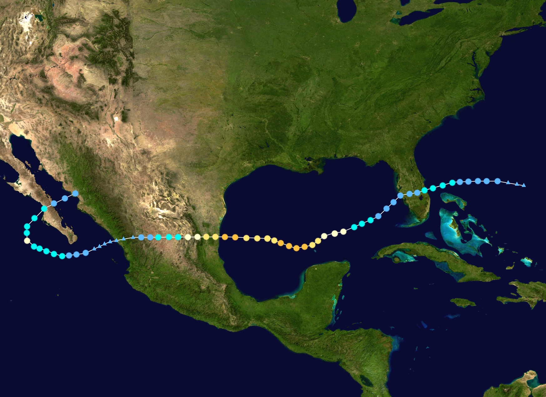
Hurricane Marco[]
| Category 3 hurricane (NHC) | |
  | |
| Duration | October 10 – October 21 (Exited basin) |
|---|---|
| Peak intensity | 120 mph (195 km/h) (1-min) 966 mbar (hPa) |
- Main article: Hurricane Marco
A low pressure area formed early on October 6, gradually organizing over warm waters and low wind shear. It was heading west toward the state of Florida at the time. It then developed into Tropical Depression Fifteen, on October 10 at 1200 UTC. It further strengthened into a tropical storm on October 11 at 1800 UTC, the NHC naming it Marco. It eventually reached its initial peak intensity 12 hours later, with winds up to 55 mph (90 km/h) and a minimum pressure of 996 mbar (hPa). It made landfall in the eastern coast of Florida on October 12 at 1200 UTC, at its initial peak intensity, just 10 mi (16 km) north of the city of St. Lucie Village. Just 6 hours after it made landfall, it weakened to a tropical depression. After it emerged from Florida to the Gulf of Mexico, Marco turned toward the southwest and started to strengthen again over favorable conditions. Marco intensified into a tropical storm again on October 15 at 1200 UTC. With that becoming a TS, it rapidly intensified into a hurricane in just 18 hours and became a Category 3 major hurricane late on October 16. It then reached its peak intensity on October 17 at 0600 UTC, with maximum sustained winds of 120 mph (195 km/h) and a minimum central pressure of 966 mbar (HPa). Shortly after its peak intensity, Marco encountered an eyewall replacement cycle. As a result, Marco weakened back to a Category 2 hurricane early on October 18. After the eyewall replacement cycle, it was able to gain strength again, reaching major status at 1800 UTC later that day. It reached its secondary peak intensity six hours later, with winds of up to 115 mph (185 km/h) and minimal pressure of 970 mbar (hPa). It made landfall in the Mexican state of Tamaulipas just a few hours later, weakening over land as it crosses the whole of Mexico. It weakened below hurricane status early on October 20, below tropical storm status the next day, and then degenerating to a remnant low at 1200 UTC that day before crossing into the Eastern Pacific basin and then redeveloping there.
Tropical Storm Nana[]
| Tropical storm (NHC) | |
  | |
| Duration | October 25 – October 28 |
|---|---|
| Peak intensity | 50 mph (85 km/h) (1-min) 999 mbar (hPa) |
On October 19, a low pressure area formed, gradually organizing as it headed east-northeast. On October 22, the NHC tracked the system, saying that it has the potential to develop into a sub/tropical storm in the next 3 days. Then, on October 25 at 18:00 UTC, it developed into Subtropical Depression Sixteen, having it not being fully tropical yet. On October 26 at 12:00 UTC, it attained tropical storm strength, earning the name, Nana. 6 hours later, it fully transitioned into a tropical storm. Nana remained a weak storm during its lifespan, peaking with winds up to 50 mph and the minimum pressure at 999 mbar (hPa) on October 27 before running into cold waters and moderate wind shear. It became an extratropical cyclone a day later.
Hurricane Omar[]
| Category 1 hurricane (NHC) | |
  | |
| Duration | November 12 – November 17 |
|---|---|
| Peak intensity | 85 mph (140 km/h) (1-min) 983 mbar (hPa) |
A tropical low formed on November 10 and it rapidly organized overtime, despite the cooler waters. It was being tracked by the NHC the next day. On November 12 at 0000 UTC, it developed into a tropical depression, turning to the west-northwest. Exactly a day later, it strengthened into Tropical Storm Omar. It eventually became a hurricane on November 15, 0000 UTC. It reached its peak intensity 12 hours later, with maximum winds of 85 mph (140 km/h) and a minimum pressure of 983 mbar (hPa). After that, it started to gradually weaken, wind shear increased slightly and temperatures declined for the storm. It went back to a tropical storm on November 16, 0000 UTC. On the 17th at 0600 UTC, it became extratropical.
Tropical Storm Paulette[]
| Tropical storm (NHC) | |
  | |
| Duration | December 4 – December 6 |
|---|---|
| Peak intensity | 45 mph (75 km/h) (1-min) 997 mbar (hPa) |
An area of low pressure formed on November 27, gradually organizing and moving westward. Despite colder temperatures, it developed into Tropical Depression Eighteen on December 4 at 0000 UTC, roughly 400 mi (645 km/h) north of the Azores. On December 5 at0000 UTC, it intensified into Tropical Storm Paulette. 12 hours later, it reached its peak intensity with sustained winds of 45 mph (75 km/h) and a minimum pressure of 997 mbar (hPa). Even colder waters gushed in, reaching a temperature of 50 F (10 C) degrees at that time, causing the storm to weaken. It fell below tropical storm strength on December 6 at 0000 UTC, its structure collapsing, and then became a post-tropical cyclone 12 hours later, hitting the Iberian Peninsula a few hours later before completely dissipating the next day.
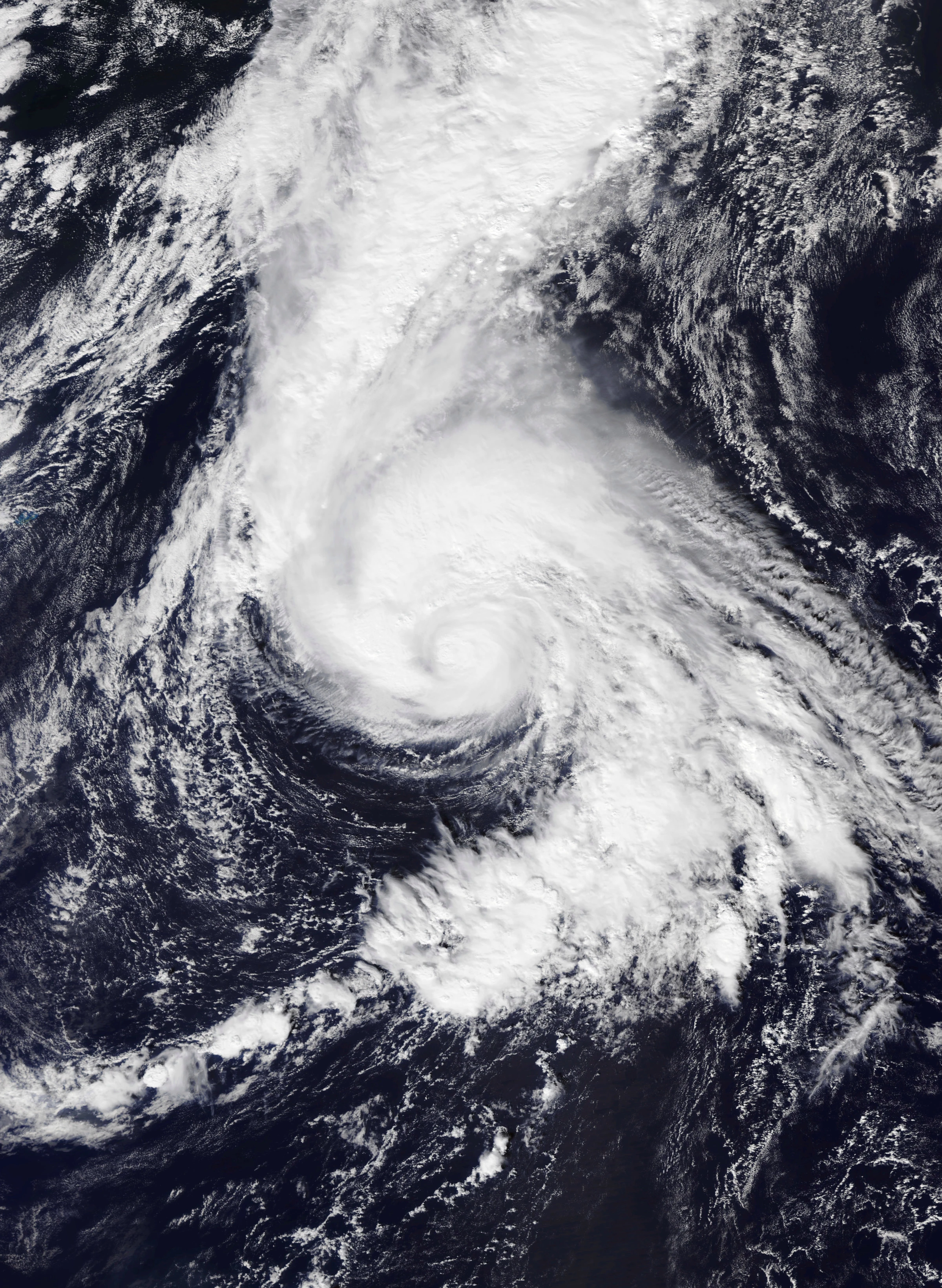
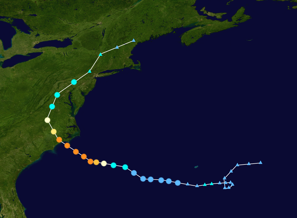
Hurricane Rene[]
| Category 4 hurricane (NHC) | |
  | |
| Duration | December 22 – December 27 |
|---|---|
| Peak intensity | 145 mph (230 km/h) (1-min) 934 mbar (hPa) |
- Main articles: Hurricane Rene (2020) and Hurricane Rene
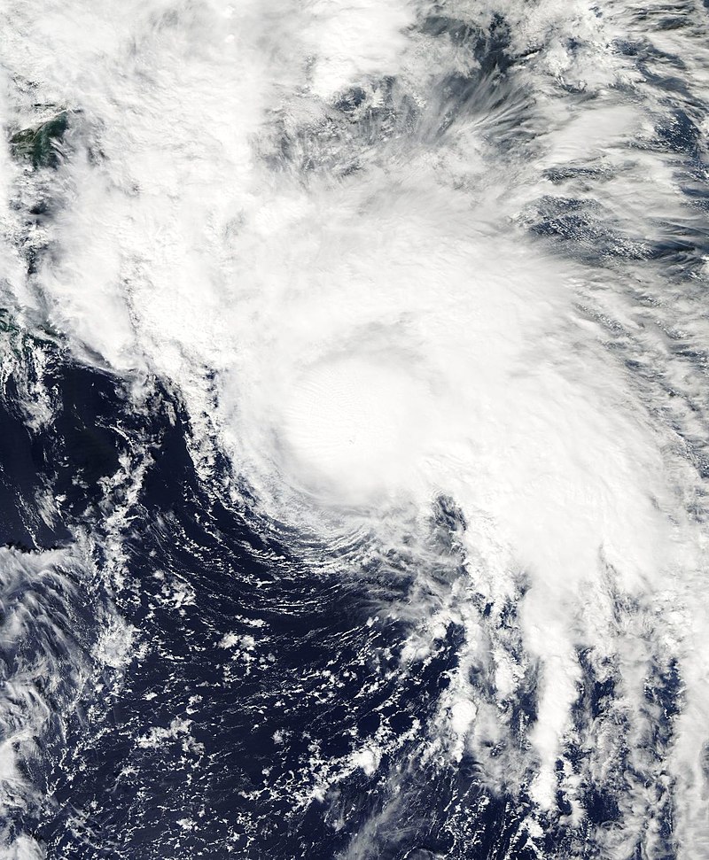
An area of low pressure formed on December 16 over cool waters. Over the next few days, it meandered the Atlantic, seeing no change in organization. On December 20, it started to organize, despite the cooler waters. On December 22 at 06:00 UTC, it was upgraded to Tropical Depression Twenty, moving westward and gradually strengthening. On December 23 at 18:00 UTC, it was upgraded to a tropical storm, the NHC naming it Rene. At that time, the temperatures very rapidly and abruptly rose, allowing the storm to rapidly intensify as well. At 06:00 UTC the next day, it strengthened into a hurricane and then just 12 hours later, into a Category 4 hurricane. It then reached its peak intensity on December 25 at 00:00 UTC, with maximum sustained winds of 145 mph (230 km/h) and a minimum central pressure of 934 mbar (hPa). Using up all the ocean’s warmth, Rene weakened while approaching North Carolina, but still holding on to Category 4 strength. Rene made landfall as a 130 mph (215 km/h)/943 mbar (hPa) hurricane at roughly 1000 UTC. Rene quickly abated during landfall, weakening from a Category 4 hurricane to a tropical storm in 18 hours. Rene remaining tropical over the United States for another 12 hours before turning post-tropical on December 27 at 0000 UTC.
ACE[]
Storm names[]
The following list of names was used for named storms that formed in the North Atlantic in 2020. The names not retired from this list will be used again in the 2026 season. This was the same list used in the 2014 season. The names Isaias, Paulette, and Rene were used for the first (with the exception for Isaias and Rene, only) time this year.
|
|
Retirement[]
On March 17, 2021 at the 43th session of the RA IV hurricane committee, the World Meteorological Organization retired the names Bertha, Isaias, Kyle, Marco, and Rene due to their destruction and fatalities they all caused, and they will not be used again for another Atlantic hurricane. The season is tied with the 2005 season and the 2025 season for having the most names retired after a single season. They will be replaced by Bessie, Ives, Kurt, Morris, and Robert respectively for the 2026 season.
Season effects[]
This is a table of all the storms that have formed in the 2020 Atlantic hurricane season. It includes their duration, names, landfall(s), denoted in parentheses, damages, and death totals. Deaths in parentheses are additional and indirect (an example of an indirect death would be a traffic accident), but were still related to that storm. Damage and deaths include totals while the storm was extratropical, a tropical wave, or a low, and all the damage figures are in USD. Potential tropical cyclones are not included in this table.
| Saffir–Simpson hurricane wind scale | ||||||
| TD | TS | C1 | C2 | C3 | C4 | C5 |
| Storm name |
Dates active | Storm category at peak intensity |
Max 1-min wind mph (km/h) |
Min. press. (mbar) |
Areas affected | Damage (USD) |
Deaths | |||
|---|---|---|---|---|---|---|---|---|---|---|
| Arthur | June 9 – 16 | Tropical storm | 60 (95) | 994 | Yucatan Peninsula, Southern United States | $188 million | 1 (2) | |||
| Bertha | June 28 – July 16 | Category 4 hurricane | 140 (220) | 938 | Southeastern United States, New England, Lesser Antilles, Canada, Puerto Rico, Bahamas | $11.72 billion | 68 (7) | |||
| Cristobal | July 4 – 8 | Category 1 hurricane | 85 (140) | 986 | Ireland | None | None | |||
| Dolly | July 14 – 27 | Category 2 hurricane | 100 (155) | 984 | West Africa, Lesser Antilles, Cuba | $458 million | 14 (4) | |||
| Edouard | July 19 – 22 | Tropical storm | 50 (85) | 997 | Southeast United States | $84 million | 1 (1) | |||
| Six | July 30 – 31 | Tropical depression | 35 (55) | 1004 | None | None | None | |||
| Fay | August 2 – 14 | Category 3 hurricane | 120 (195) | 971 | West Africa, Ireland, United Kingdom | Minimal | None | |||
| Gonzalo | August 11 – 14 | Tropical storm | 40 (65) | 1001 | None | None | None | |||
| Hanna | August 12 – 23 | Category 1 hurricane | 80 (130) | 989 | Florida, Newfoundland and Labrador | $210 million | 3 (3) | |||
| Isaias | September 1 – 13 | Category 4 hurricane | 150 (240) | 934 | Southern United States, Belize, Southeastern Mexico | $8.83 billion | 92 (27) | |||
| Eleven | September 6 – 8 | Tropical depression | 35 (55) | 1002 | None | None | None | |||
| Josephine | September 8 – 17 | Category 1 hurricane | 85 (140) | 985 | None | None | None | |||
| Kyle | September 19 – October 9 | Category 5 hurricane | 175 (280) | 903 | West Africa, Lesser Antilles, Puerto Rico, U.S. Virgin Islands, Dominican Republic, Bermuda, Northeastern United States | $259 billion | 16725 (1566) | |||
| Laura | September 25 – 28 | Category 1 hurricane | 80 (130) | 994 | Azores | Minor | 1 | |||
| Marco | October 10 – 21 | Category 3 hurricane | 120 (195) | 966 | Florida, Yucatan Peninsula, Mexico | $6.19 billion | 112 (60) | |||
| Nana | October 25 – 28 | Tropical storm | 50 (85) | 999 | None | None | None | |||
| Omar | November 12 – 17 | Category 1 hurricane | 85 (140) | 983 | None | None | None | |||
| Paulette | December 4 – 6 | Tropical storm | 45 (75) | 997 | Iberian Peninsula | Minimal | None | |||
| Rene | December 22 – 27 | Category 4 hurricane | 145 (230) | 934 | Southeastern United States, New England, Canada | $22.73 billion | 3024 (1153) | |||
| Season aggregates | ||||||||||
| 19 systems | June 9 – December 27 |
175 (280) | 903 | $309.41 billion | 23110 | |||||