The 2022 Atlantic hurricane season was a slightly below average season that produced 11 named storms, 4 hurricanes, and 2 major hurricanes. The season featured pre-season activity, with Tropical Storm Alex forming on May 17. Despite the El Niño event, above normal sea surface temperatures kept activity only slightly below average. The season ran from May to October, which is earlier than the normal. For the first time since 2016, July did not feature a named storm. The season's end in October was the first since 2012. 2022 also featured no Caribbean activity.
Despite the inactivity, there were a couple notable storms. In May, Tropical Storm Alex formed and struck the Carolinas. In August, Tropical Storm Fiona caused flooding across Florida when it made landfall. In September, Hurricane Hermine struck Cuba as a Category 4 Hurricane before hitting the U.S gulf coast as a minimal hurricane. In October, Hurricane Karl caused localized damage in the Azores, ending the 2022 season.
Timeline[]

Overall, the season's activity was reflected with a low cumulative accumulated cyclone energy (ACE) rating of 61. ACE is, broadly speaking, a measure of the power of the hurricane multiplied by the length of time it existed, so storms that last a long time, as well as particularly strong hurricanes, have high ACEs.
Storms[]
|
Tropical Storm Alex[]
| Tropical storm (SSHWS) | |
  | |
| Duration | May 17 – May 20 |
|---|---|
| Peak intensity | 45 mph (75 km/h) (1-min) 1005 mbar (hPa) |
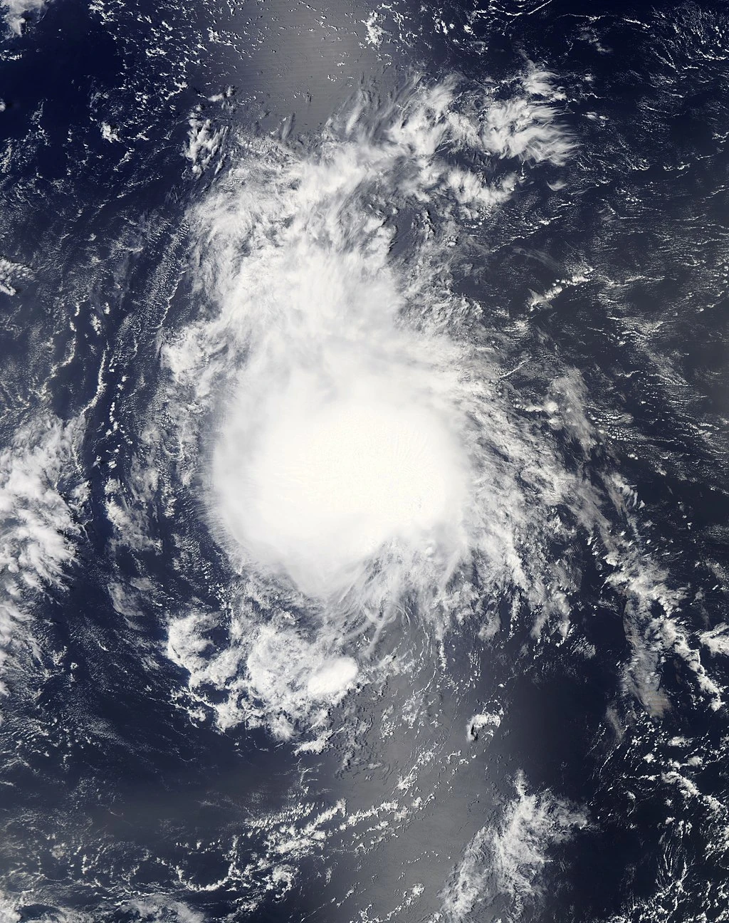
A large trough was present of the Gulf of Mexico in late May. A part of the trough broke off and remained stationary over the Gulf as the Trough moved northeast. It crossed over Florida, and began to show some signs of organization as it remained just off the coast. Developing into a Subtropical Depression on May 17, it quickly intensified into Subtropical Storm Alex. Marginal conditions around the storm allowed for gradual intensification, and Alex peaked with 45 mph. Some weakening occurred before landfall in North Carolina on May 19. Alex quickly weakened over land, and was declared a post-tropical cyclone on May 20.
Tropical Storm Bonnie[]
| Tropical storm (SSHWS) | |
  | |
| Duration | June 21 – June 23 |
|---|---|
| Peak intensity | 45 mph (75 km/h) (1-min) 1003 mbar (hPa) |
A broad low pressure area developed over the Western Caribbean on June 18. Gradually moving in a westward direction, it emerged over the Bay of Campeche and developed into Tropical Depression Two on June 21. Initially struggling with strong wind shear, the Depression did not intensify much. However, on June 22, as it was approaching the Mexican coast, it intensified into Tropical Storm Bonnie, and quickly attained peak winds of 45 mph before making landfall in Veracruz. Weakening quickly commenced, and Bonnie was declared remnants on June 23.
Tropical Depression Three[]
| Tropical depression (SSHWS) | |
  | |
| Duration | July 9 – July 10 |
|---|---|
| Peak intensity | 35 mph (55 km/h) (1-min) 1006 mbar (hPa) |
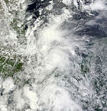
A tropical wave emerged off the coast of Africa on July 4. It struggled to develop initially due to very dry air and some wind shear in the Main Development Region, but conditions were expected to become more favorable. As shear decreased around the system, convection rapidly increased and a tight center formed, leading to the declaration of Tropical Depression Three on July 9. Three moved swiftly westward, making landfall in Guadeloupe on July 9. Early the next morning, strong wind shear in the Caribbean teared Three into a remnant low. The remnants would bring squally weather to Puerto Rico and the Dominican Republic.
Tropical Storm Colin[]
| Tropical storm (SSHWS) | |
  | |
| Duration | August 3 – August 6 |
|---|---|
| Peak intensity | 65 mph (100 km/h) (1-min) 992 mbar (hPa) |
A tropical wave moved off the coast of Africa, and entered the Caribbean sea. Despite some wind shear, convection gradually increased, and the NHC noted that a TC could form at any time. Convection began to decrease however, but the low remained well-defined as it emerged into the Bay of Campeche. In favorable conditions, Tropical Depression Four formed on August 3, and became Tropical Storm Colin that evening. The NHC stated that rapid intensification was likely, given that low shear and warm waters were present. However, Colin struggled with it's core for most of the day on August 4, but on August 5, rapid intensification began as banding features developed with the storm, and Colin peaked with 65 mph winds as it made landfall in northern Mexico. The weakening storm moved into south Texas, and completely dissipated on August 6.
Hurricane Danielle[]
| Category 1 hurricane (SSHWS) | |
  | |
| Duration | August 18 – August 26 |
|---|---|
| Peak intensity | 80 mph (130 km/h) (1-min) 984 mbar (hPa) |
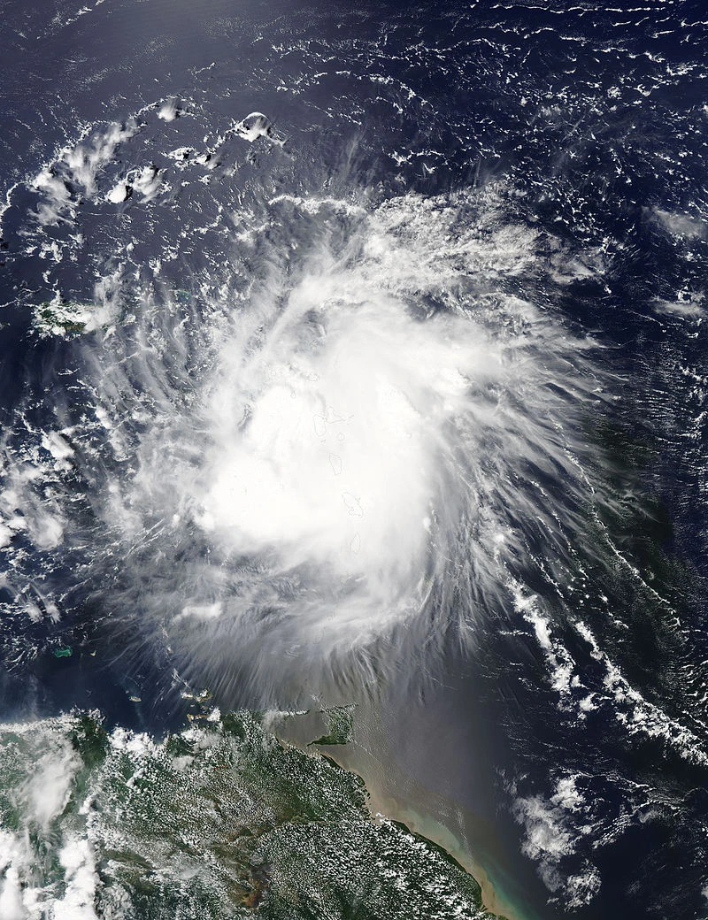
A tropical wave that had moved off Africa developed into Tropical Depression Five. In fairly favorable conditions, it intensified into Tropical Storm Danielle on August 19. The storm was initially forecast to make landfall in the Dominican Republic, and Tropical Storm Warnings were raised, but Danielle passed just to the north. Tropical Storm Conditions did affect the northeastern quadrant, however. Danielle suddenly executed a northward turn, and intensified into a hurricane on August 23. The storm developed well-defined banding and a clouded eye feature as it peaked with 80 mph winds, before increased shear caused some weakening. Baroclinic forcing briefly allowed Danielle to re-intensify into a hurricane on August 25, before it rapidly moved to the east, becoming extratropical on August 26.
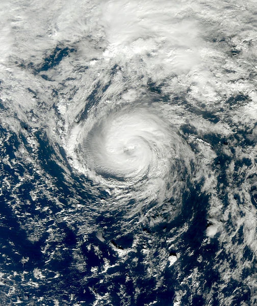
Hurricane Earl[]
| Category 3 hurricane (SSHWS) | |
  | |
| Duration | August 23 – August 30 |
|---|---|
| Peak intensity | 120 mph (195 km/h) (1-min) 958 mbar (hPa) |
A tropical wave moved off the coast of Africa, behind the wave that would become Fiona. On August 23, it developed into Tropical Storm Earl southwest of the Cape Verde Islands. Despite a fairly dry environment, Earl intensified into a hurricane on August 25 as an eye developed. Gradual intensification led to Earl becoming a major hurricane the next day, and peaking with 120 mph winds, a Category 3 Hurricane. Shortly after peak, cooler waters began to induce weakening. Earl curved east around a high, retaining Category 1 intensity as an eye fluctuated on satellite imagery. Earl accelerated east, becoming post-tropical an August 30 as the remnant cyclone meandered in the northern Atlantic, before being absorbed on September 3.
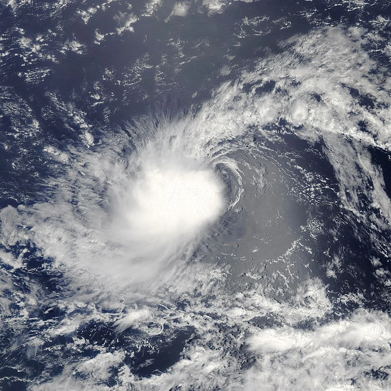
Tropical Storm Fiona[]
| Tropical storm (SSHWS) | |
  | |
| Duration | August 26 – August 31 |
|---|---|
| Peak intensity | 60 mph (95 km/h) (1-min) 1002 mbar (hPa) |
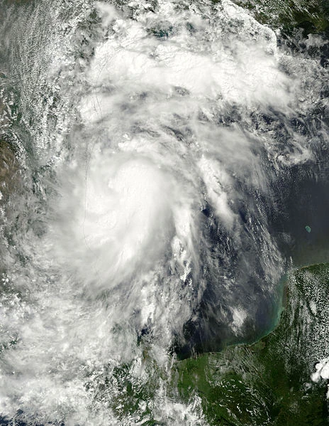
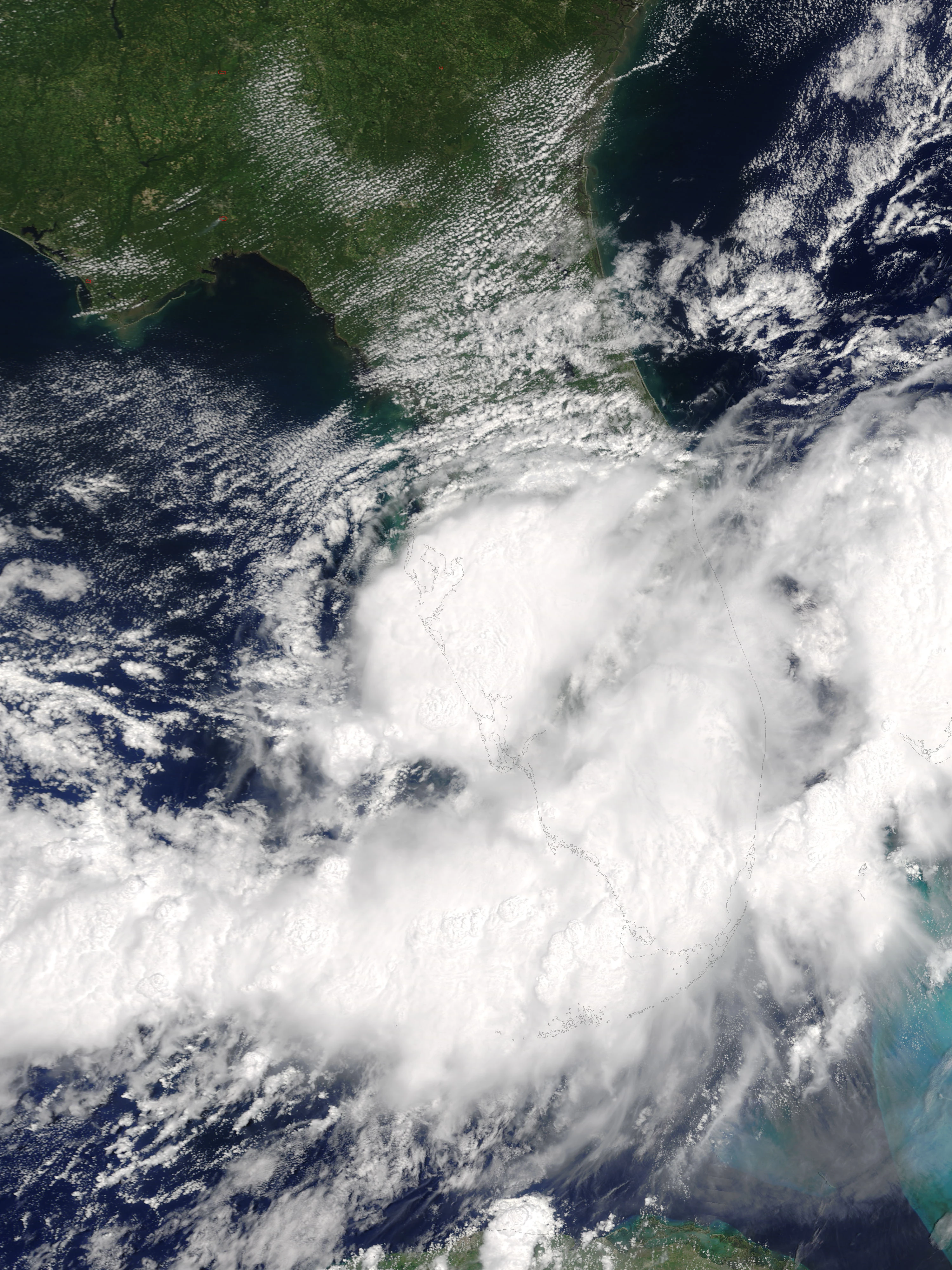
A tropical wave was tracked as it moved across the Atlantic. Despite the wave was anticipated to develop east of the Caribbean, little change in structure occurred. Stronger wind shear in the Caribbean caused the NHC to almost drop the wave at one point. In the Western Caribbean, convection rapidly increased. Potential Tropical Cyclone Seven formed on August 25. It crossed over Cuba into the Gulf of Mexico, and quickly developed into Tropical Depression Seven, and into Tropical Storm Fiona the next day. In an area of low steering currents, Fiona moved erratically, fluctuating between Tropical Storm and Depression status, due to some wind shear. On August 29, Fiona began to quickly intensify due to a convective burst, and made landfall near Naples, Florida, with winds of 60 mph. The storm quickly crossed Florida and weakened slightly, and emerged over the Bahamas. The weakening storm lost tropical characteristics on August 31.
Tropical Storm Gaston[]
| Tropical storm (SSHWS) | |
  | |
| Duration | September 13 – September 15 |
|---|---|
| Peak intensity | 40 mph (65 km/h) (1-min) 1006 mbar (hPa) |
After a two-week period of no tropical activity, Tropical Depression Eight formed on September 13, and intensified into Tropical Storm Gaston six hours later. Despite the storm was forecast to move northwest into more favorable conditions, and possibly become a hurricane, Gaston remained on a westward track and weakened as it entered an area of increased wind shear. Gaston weakened as it approached the Caribbean, and the storm dissipated on September 15.
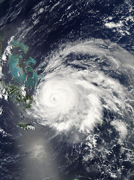
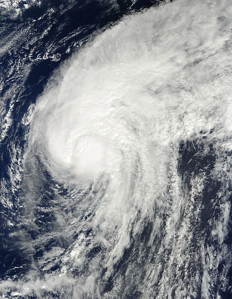
Hurricane Hermine[]
| Category 4 hurricane (SSHWS) | |
  | |
| Duration | September 17 – September 30 |
|---|---|
| Peak intensity | 145 mph (230 km/h) (1-min) 938 mbar (hPa) |
- Main article: Hurricane Hermine
A tropical wave moved off the coast of Africa on September 11. It gradually organized in the coming days due to somewhat favorable conditions, and a Tropical depression formed on September 17. Intensifying into Tropical Storm Hermine, the storm briefly intensified into a hurricane on September 20, before weakening due to a brief increase in wind shear. However, this shear subsided, and favorable conditions in the path of the storm allowed Hermine to begin rapid intensification on September 23. Hermine was upgraded to a major hurricane north of Hispaniola on September 25, the second and final one of the season. Hermine developed a large eye and continued on a path toward Cuba, until it made landfall in Playa Santa Lucia, at peak intensity as a moderate Category 4 hurricane. Hermine traversed the length of Cuba, weakening significantly. It emerged off the Cuban coast on September 26, as a tropical storm. Hermine gradually re-intensified over the Gulf of Mexico, eventually re-intensifying into a minimal hurricane, and making landfall in Rosemary Beach, Florida, with winds of 75 mph. Hermine weakened inland, and was declared post-tropical on September 30.
Tropical Storm Ian[]
| Tropical storm (SSHWS) | |
  | |
| Duration | September 20 – September 28 |
|---|---|
| Peak intensity | 45 mph (75 km/h) (1-min) 1001 mbar (hPa) |
A tropical wave emerged off the coast of Africa on September 18, and quickly began to develop, becoming a Tropical Depression on September 20. On September 22, the Depression intensified into Tropical Storm Ian. Despite the NHC was anticipating gradual intensification to near hurricane status, Ian struggled with strong wind shear its entire 8-day lifespan, not being able to intensify past 45 mph. By September 26, Ian was becoming very disorganized and conditions were not looking any more favorable. Continued weakening occurred until September 28, when Ian degenerated into a Tropical wave just off the Lesser Antilles.
Tropical Storm Julia[]
| Tropical storm (SSHWS) | |
  | |
| Duration | October 5 – October 8 |
|---|---|
| Peak intensity | 50 mph (85 km/h) (1-min) 1004 mbar (hPa) |
A frontal system began to show signs of organization on October 2. As it moved across the Atlantic, it broke off from the front and gradually gained subtropical characteristics, until a Subtropical Depression formed on October 5. Late that night, it transitioned into a Tropical System and was named Julia. Julia moved in a northward motion while gradually gaining strength, peaking with wind speeds of 50 mph. After this, Julia stalled and began to weaken as shear increased. The storm completed its small loop and accelerated northward, becoming post-tropical on October 8.
Hurricane Karl[]
| Category 1 hurricane (SSHWS) | |
  | |
| Duration | October 19 – October 22 |
|---|---|
| Peak intensity | 85 mph (140 km/h) (1-min) 981 mbar (hPa) |
An unusual late-season increase in convection in the ITCZ allowed for a tropical wave to form on October 14. This wave moved unusually, moving almost directly northward and changing speed erratically. On October 19, it was declared a Tropical Storm, and named Karl. Karl gradually intensified due to its large structure, becoming a hurricane on October 20 and peaking early the next day with 85 mph winds. After this time, Karl entered cooler waters and was picked up by a trough, causing it to accelerate and weaken. Karl became post-tropical on October 22, as it was passing through the Azores. Karl's dissipation marked the end of the 2022 Atlantic hurricane season.
Season Effects[]
| Storm name |
Dates active | Storm category at peak intensity |
Max 1-min wind mph (km/h) |
Min. press. (mbar) |
Areas affected | Damage (USD) |
Deaths | |||
|---|---|---|---|---|---|---|---|---|---|---|
| Alex | May 17 – May 20 | Tropical storm | 45 | 1005 | United States, Bahamas | 17.4 | 4 | |||
| Bonnie | June 21 – June 23 | Tropical storm | 45 | 1003 | Mexico | Minimal | 2 | |||
| Three | July 9 – July 10 | Tropical depression | 35 | 1006 | Leeward Islands, Puerto Rico, Dominican Republic | Minimal | None | |||
| Colin | August 3 – August 6 | Tropical storm | 65 | 992 | Mexico, United States | 107 | 5 | |||
| Danielle | August 18 – August 26 | Category 1 hurricane | 80 | 984 | Lesser Antilles, Puerto Rico, Dominican Republic, United States, Bermuda | 25 | 1 | |||
| Earl | August 23 – August 30 | Category 3 hurricane | 120 | 958 | None | None | None | |||
| Fiona | August 26 – August 31 | Tropical storm | 60 | 1002 | Cuba, United States, Bahamas | 206 | 15 | |||
| Gaston | September 13 – September 15 | Tropical storm | 40 | 1006 | None | None | None | |||
| Hermine | September 17 – September 30 | Category 4 hurricane | 145 | 938 | Lesser Antilles, Puerto Rico, Dominican Republic, Haiti, Bahamas, United States, Canada | 5,205 | 39 | |||
| Ian | September 20 – September 28 | Tropical storm | 45 | 1001 | Cape Verde | None | None | |||
| Julia | October 5 – October 8 | Tropical storm | 50 | 1004 | None | None | None | |||
| Karl | October 18 – October 22 | Category 1 hurricane | 85 | 981 | Azores | Minimal | 1 | |||
| Season aggregates | ||||||||||
| 12 systems | May 17 – October 22 | 145 | 938 | $5.56 Billion | 67 | |||||
Storm Names[]
The following names were used to name storms that formed in the North Atlantic in 2022. This is the same list used in the 2016 season, except for Martin and Owen, which replaced Matthew and Otto, respectively. No storms received new names in 2022.
|
|
|
Retirement[]
Due to the storm's damages and deaths, the name Hermine was retired at the WMO convention in the spring of 2023. The name Hailey was chosen to replace it, and was first used in the 2028 season.