The 2023 Atlantic hurricane season was a slightly above average hurricane season that produced approximately 14 named storms, with 8 of them becoming hurricanes, and 3 of them becoming major hurricanes. The season officially began on June 1, 2023, and ended on November 30, 2023. These dates historically describe the period each year when most tropical cyclones form in the Atlantic basin. The first system of the season, Arlene, formed on June 14, 2 weeks the season officially started. while the final storm of the season, Nigel, dissipated on November 16, prior to the end of the season. This season was the first of four below average to average seasons to occur in a row. This season was the costliest season since 2021.
Seasonal Timeline

Systems
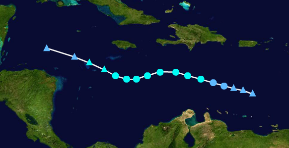
Hurricane Arlene
| Category 1 hurricane (SSHWS) | |
  | |
| Duration | June 14 – June 19 |
|---|---|
| Peak intensity | 90 mph (150 km/h) (1-min) 991 mbar (hPa) |
On June 13, a broad area of low pressure associated with a Tropical disturbance was located north of the Bahamas, showing signs of development. The disturbance gradually tracked northwestwards, and formed a closed circulation on June 14. The system was then designated as a Tropical Storm and received the name "Arlene". The storm then rapidly intensified due to unusually favorable conditions, and became a Hurricane on June 16. The storm then began to curve northeastwards and began to weaken steadily. Arlene had weakened to a Tropical Storm by early on June 17. The system posed a threat to the New England coast, and Tropical Storm warnings were issued during the Night-time hours. After having recurved northwestwards, the storm made landfall with winds of roughly 50 mph early on June 19 in Massachusetts. The storm then rapidly degenerated and merged with a frontal system later on June 19. Arlene's remnants would continued to gradually move over Canada, bringing gale-force winds in the process.
Tropical Storm Bret
| Tropical storm (SSHWS) | |
  | |
| Duration | June 30 – July 2 |
|---|---|
| Peak intensity | 50 mph (85 km/h) (1-min) 1002 mbar (hPa) |
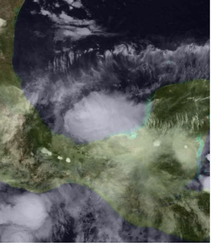
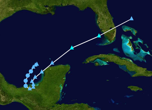
On June 29, a tropical disturbance was located off the Yucatán Peninsula, showing signs of development. The disturbance gradually intensified and eventually formed a closed circulation on June 30 and was designated as a Tropical Depression. The storm moved northwestwards into the Gulf of Mexico, continuing to gradually intensify. The depression became a Tropical Storm on July 1 and received the name "Bret". The system then started encountering an area of very high wind-shear, which caused the storm's structure to deteriorate. Bret then degenerated into a frontal system on July 2. The remnants of the storm would eventually make landfall in Florida and bring flooding rains with gale-force winds.
Tropical Depression Three
| Tropical depression (SSHWS) | |
  | |
| Duration | July 9 – July 10 |
|---|---|
| Peak intensity | 35 mph (55 km/h) (1-min) 1008 mbar (hPa) |
On July 8, a disturbed area of weather associated with a tropical low was located in the Gulf of Mexico, showing signs of development. The disturbance gradually drifted southwestwards and showed signs of organization. The disturbance was officially classified as a Tropical Depression on July 9. The system struggled to intensify due to unfavorable surface conditions. As the system gradually moved southwards, it dumped flooding rains across the coast of Mexico. The Depression quickly degenerated into a tropical wave by the morning of July 10. The storm's remnants would eventually go on to affect Florida.
Tropical Storm Cindy
| Tropical storm (SSHWS) | |
  | |
| Duration | July 17 – July 22 |
|---|---|
| Peak intensity | 65 mph (100 km/h) (1-min) 992 mbar (hPa) |
A non-tropical low was located just west of Bermuda, and was forecast to eventually acquire subtropical characteristics. The low pressure system moved in a southerly direction and eventually acquired subtropical characteristics. The system eventually became Subtropical Storm Cindy on July 17. The system made a loop and eventually became a Tropical Cyclone by early on July 19. The system continued gradually intensifying as it tracked northwestwards. As the system meandered off the coast of the United States, high surf affected areas ranging from southern Florida to southeastern Maine. Cindy sharply curved northeastwards and began to weaken due to unusually unfavorable conditions along the Gulf Stream. Cindy weakened to a Depression by the morning of July 22. Twelve hours later, the system degenerated into a post-tropical system, and continued tracking across the open Atlantic.
Hurricane Don
| Category 4 hurricane (SSHWS) | |
  | |
| Duration | August 2 – August 14 |
|---|---|
| Peak intensity | 135 mph (215 km/h) (1-min) 948 mbar (hPa) |
On July 31, a tropical disturbance was located southwest of the Cabo Verde Islands, showing signs of organization. The disturbance initially struggled to intensify due to the lack of a closed circulation. The disturbance drifted westwards, and finally formed a closed circulation early on August 2, and became Tropical Storm Don. The storm made a turn to the southwest, getting close to around the 5°N mark. Don eventually intensified into a Hurricane late on August 3, and began to turn northwestwards later that day. The storm entered a very favorable area for intensification, resulting in Don eventually becoming a Major Hurricane by August 6. As the storm continued moving northwest, it intensified into a Category 4 Hurricane on August 7. While the storm did not directly impact land, Tropical Storm-force winds were recorded on the northernmost islands of the Lesser Antilles. Don began to weaken as it moved further northwards, the storm also made a curve towards the east, fueling the weakening of the storm further. Once the storm recurved to the northwest late on August 10, it weakened down to a Tropical Storm. As Don passed by Bermuda, the storm began to undergo an extra-tropical transition. The storm became a remnant low on August 12, and the remnants of the storm would continued to drift across the Atlantic for around 2 more days before being absorbed by a frontal system.
Tropical Storm Emily
| Tropical storm (SSHWS) | |
  | |
| Duration | August 7 – August 10 |
|---|---|
| Peak intensity | 45 mph (75 km/h) (1-min) 1004 mbar (hPa) |
Late on August 5, a disturbed area of low pressure associated with a tropical wave was located in the central Caribbean sea. By early on August 7, the system formed a closed center of circulation and became a Tropical Depression. The system gradually tracked towards the northwest and struggled to initially intensify. The storm intensified into a Tropical Storm by late on August 8. The storm couldn't intensify further due to moderate amounts of wind-shear. Prior to making landfall in Cuba, Emily weakened into a Depression. Emily then made landfall in Cuba as a Depression with winds of around 35 mph. Shortly after making landfall, Emily degenerated into a remnant low over Cuba. The storm's remnants would eventually stall north of Cuba, bringing heavy rains.
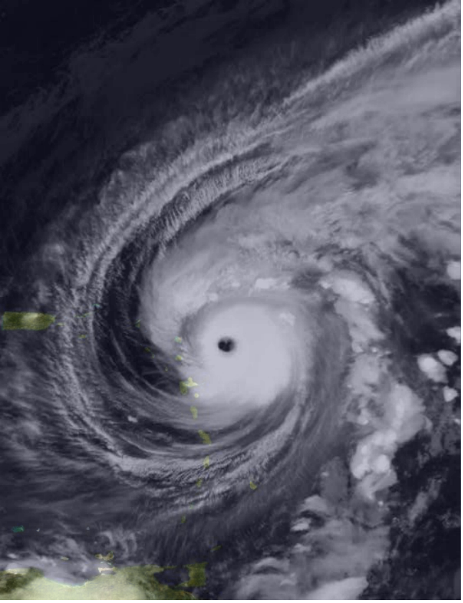
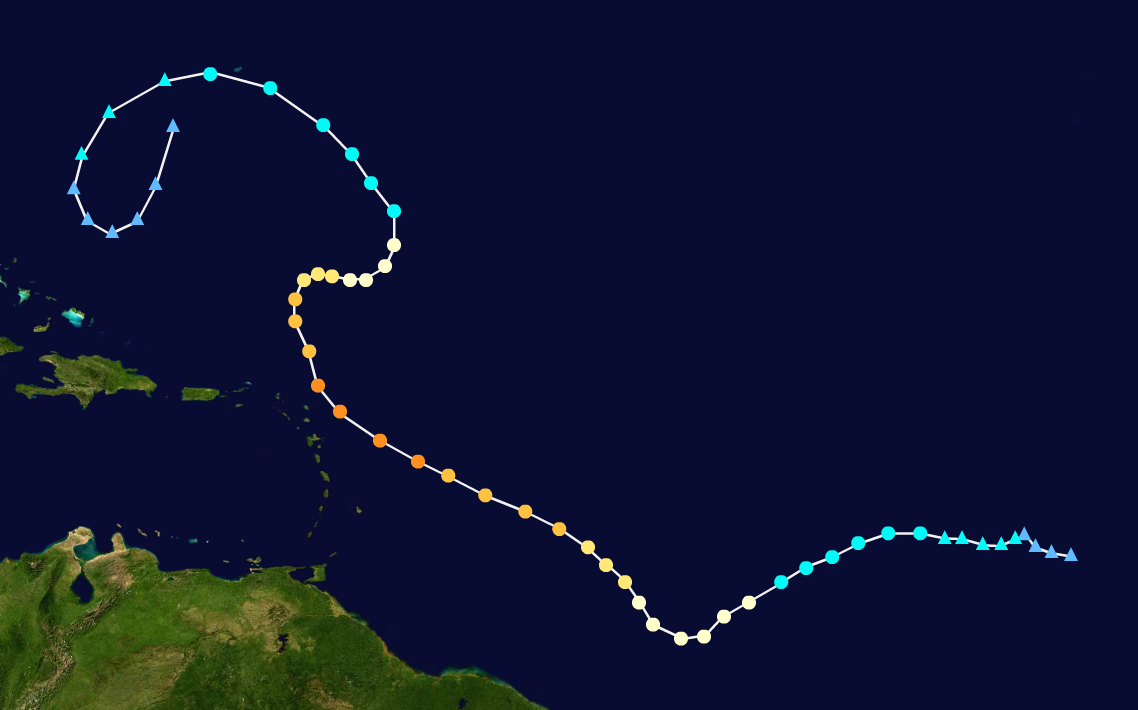
Hurricane Franklin
| Category 4 hurricane (SSHWS) | |
  | |
| Duration | August 25 – September 11 |
|---|---|
| Peak intensity | 155 mph (250 km/h) (1-min) 917 mbar (hPa) |
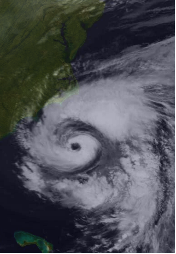
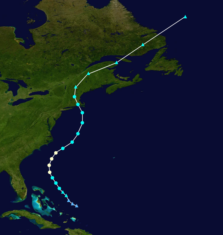
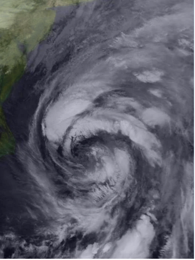
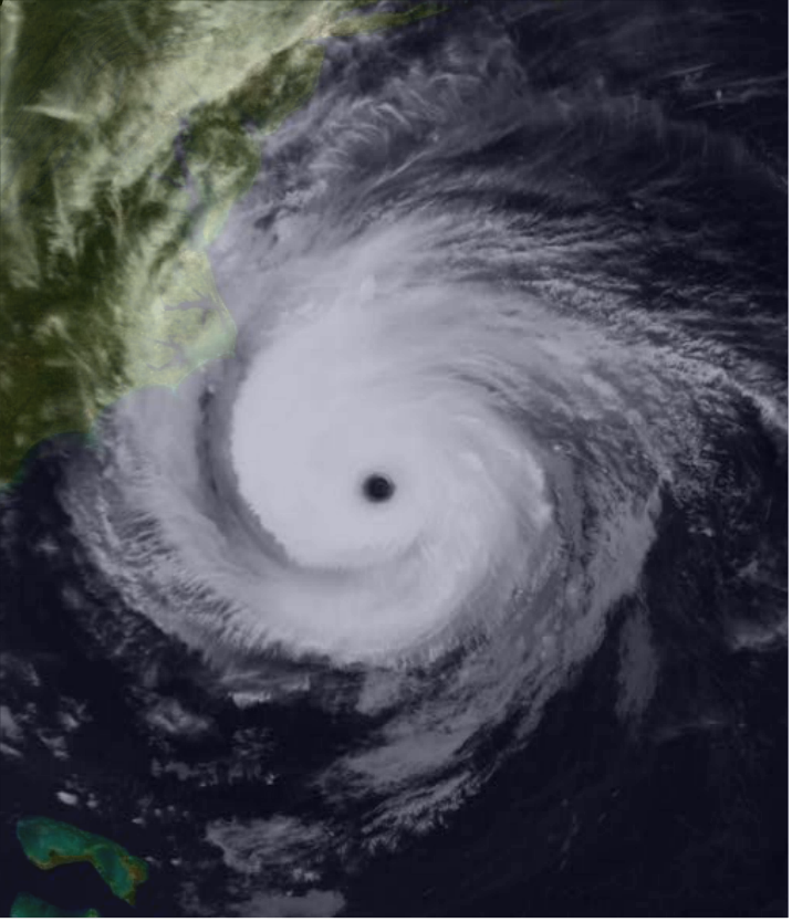
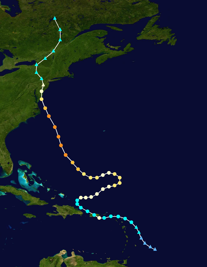
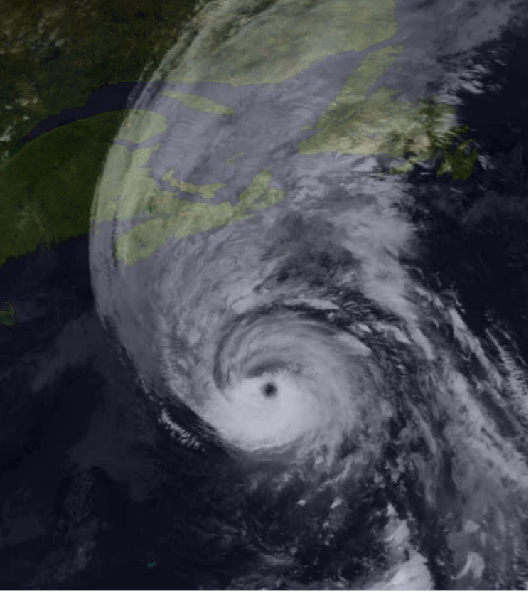
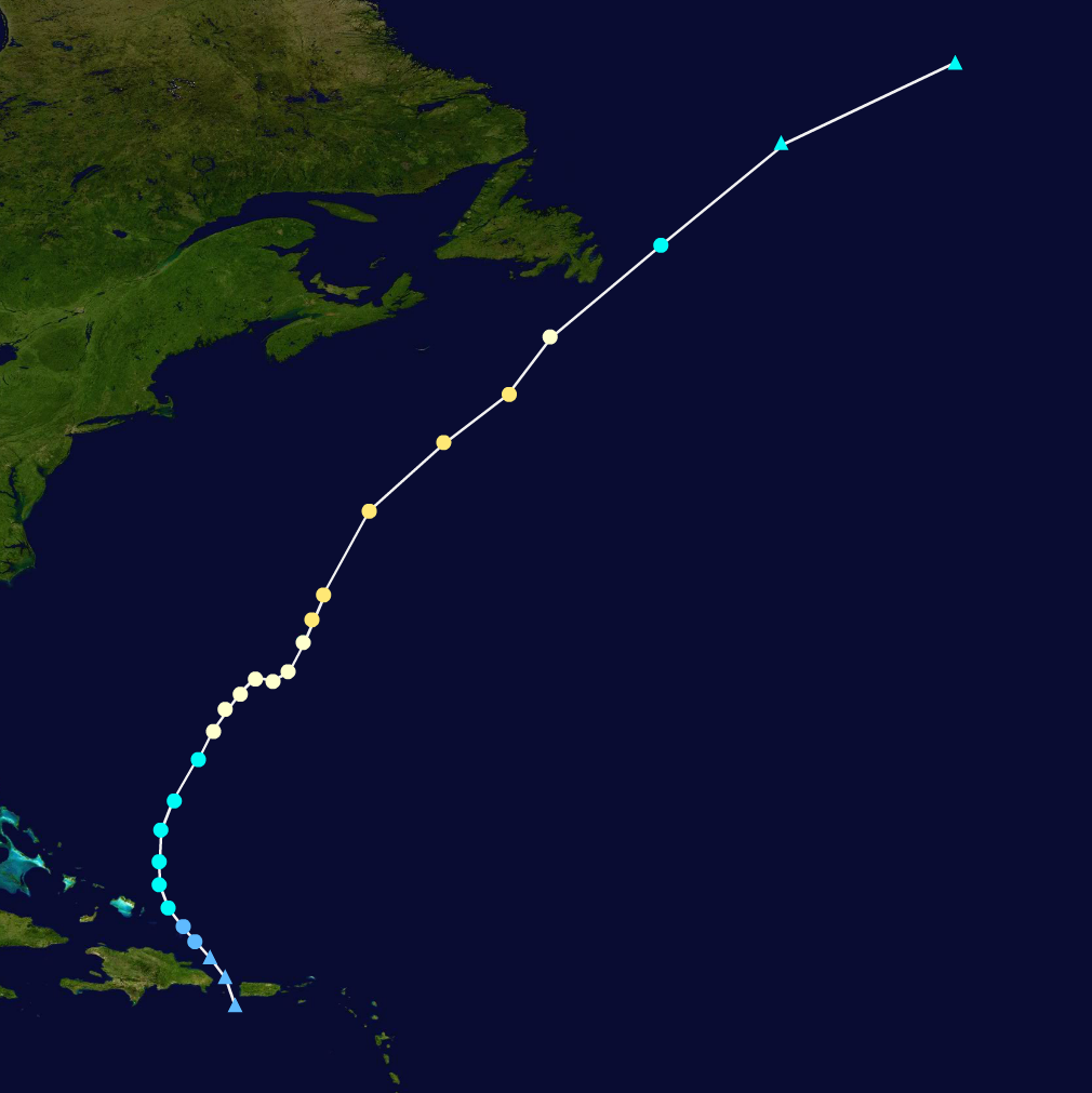
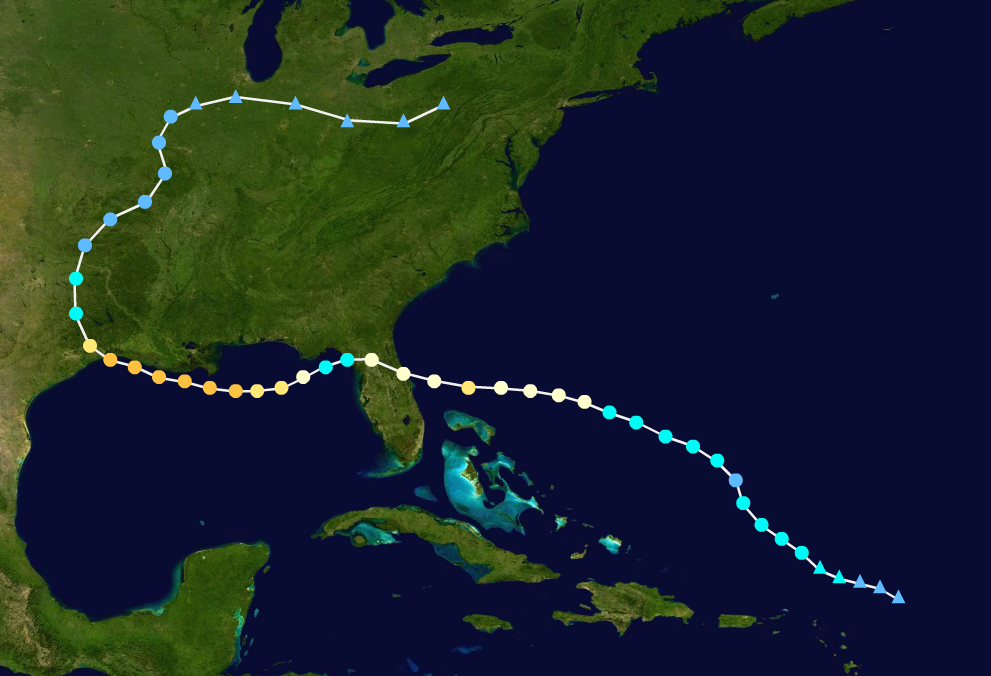
A disturbed area of weather was located east of the Lesser Antilles on August 24, with high chances of development. The disturbance gradually organized over the next 48 hours, becoming Tropical Storm Franklin on August 25. Franklin gradually moved towards the west, and tropical storm warnings were issued for Puerto Rico late on August 25. Just before making its first landfall, the storm intensified into a Category 1 Hurricane, making landfall at that intensity early on August 27. Franklin then weakened into a Tropical Storm shortly after making landfall and continued moving westwards. The storm then began to curve towards the east, entering a favorable area for intensification. The storm re-intensified into a Hurricane by August 29. Franklin continued to gradually drift towards the northeast, but began to loop again. The storm started curving westwards on September 2, and intensified into a Category 2 hurricane while doing so. The storm weakened a bit after turning westwards, but quickly re-intensified. The storm began moving northwestwards again starting on September 6. Hurricane warnings were issued for the Mid-Atlantic coast of the United States on September 7. Franklin then began to rapidly intensify and became a Category 4 Hurricane on September 8. The storm then began to bring storm surge across states ranging from South Carolina to Massachusetts, and Hurricane Warnings began to be issued around the same time. Nine hours before the storm made landfall, it weakened down into a Category 3, and tropical storm-force winds began affecting the states of Delaware, Maryland, and Virginia. The Storm made landfall as a high-end Category 2 Hurricane with winds of 110 mph on the coast of Delaware late on September 10. After moving inland, the storm rapidly degenerated due to land interaction. Franklin degenerated into a remnant low around 12 hours after making landfall, and the storm's remnants moved into Canada by September 13.
This storm became the strongest storm to ever affect the northeast coast of the United States since 1938, and was the Strongest storm to make landfall in the state of Delaware. The damage the storm caused was described as "something the region had never seen", and also as "Apocalyptic". Multiple deaths were attributed to the massive storm surge Franklin produced, and waves reached as high as 25 ft in some places.
Hurricane Gert
| Category 1 hurricane (SSHWS) | |
  | |
| Duration | September 2 – September 7 |
|---|---|
| Peak intensity | 85 mph (140 km/h) (1-min) 982 mbar (hPa) |
On September 1, a tropical disturbance was located in the central Atlantic Ocean, showing signs of organization. The disturbance quickly organized into a Tropical Storm on September 2, and received the name "Gert". The storm quickly intensified due to very low wind-shear and warm sea surface temperatures in excess of the storm. Gert began to turn northwards early on September 4, and became a Hurricane in the process. The storm maintained Category 1 Hurricane status for the next 36 hours before eventually turning westwards. Gert weakened back into a Tropical Storm early on September 6. The storm began to rapidly weaken due to stalling and entering an area of higher wind-shear. Gert then turned southwards and rapidly degenerated into a remnant low by September 7. The storm's remnants would eventually go on to affect the northernmost Lesser Antilles, brining gale-force winds and heavy rains to the area.
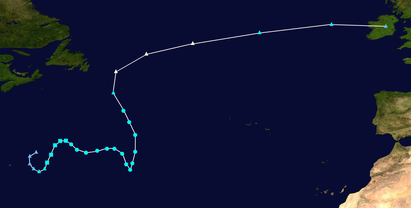
Hurricane Harold
| Category 1 hurricane (SSHWS) | |
  | |
| Duration | September 4 – September 7 |
|---|---|
| Peak intensity | 75 mph (120 km/h) (1-min) 990 mbar (hPa) |
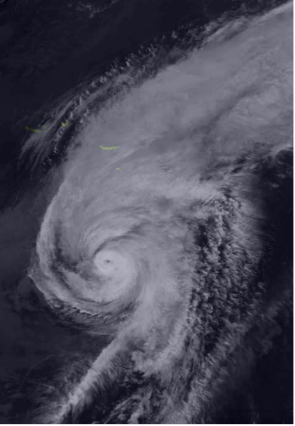
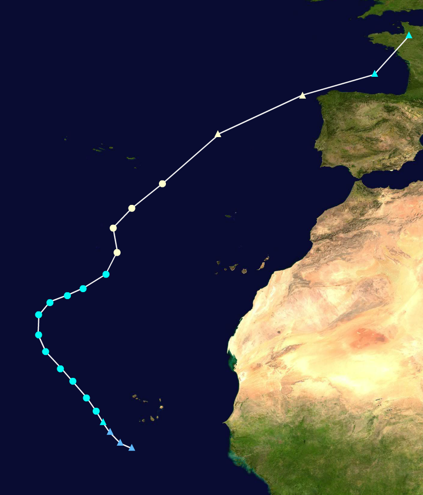
On September 3, a tropical wave was located just southeast of the Cabo Verde Islands, showing signs of organization. The system gradually acquired tropical characteristics over the next 24 hours. By September 4, the disturbance formed a closed circulation and was classified as a Tropical Storm, receiving the name "Harold". The system gradually tracked towards the northwest, and began intensifying at a moderate rate. Starting on September 5, the system curved northeastwards, and entered an area that had unusually favorable surface conditions, further fueling the storm's intensification rate. Harold became a Category 1 Hurricane late on September 6, and continued to track eastwards. The storm began to undergo an extratropical transition on September 7, and became post-tropical later that day. Harold' remnants would go on to bring hurricane-force winds to the Iberian peninsula and the coast of France.
Hurricane Idalia
| Category 2 hurricane (SSHWS) | |
  | |
| Duration | September 10 – September 18 |
|---|---|
| Peak intensity | 100 mph (155 km/h) (1-min) 970 mbar (hPa) |
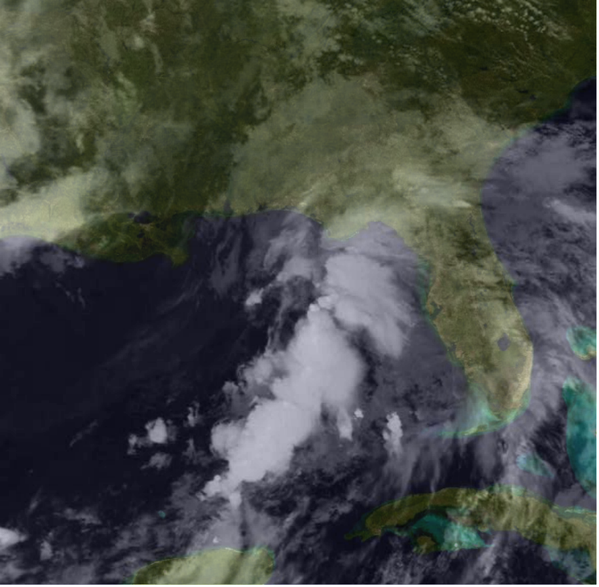
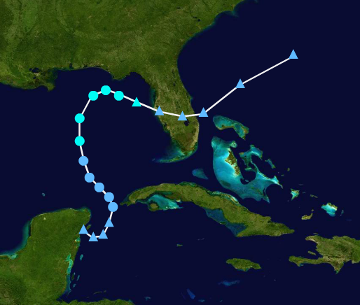
Late on September 9, a disturbed area of low pressure associated with a tropical wave was located a couple hundred miles southeast of the Lesser Antilles. The disturbance quickly organized into a Tropical Storm early the next day, receiving the name "Idalia". Soon after forming, Tropical Storm warnings were issued for Trinidad and Tobago, along with the southernmost Lesser Antilles. Idalia made landfall in Trinidad as a minimal Tropical Storm with winds of approximately 45 mph on September 10. After making landfall, the storm moved into the Caribbean sea, and gradually intensified further. Eventually, Idalia became a Hurricane early on September 12. Hurricane watches were issued for the island of Jamaica that same day. Idalia continued to move northwestwards, briefly intensifying into a Category 2 hurricane just south of Jamaica, before eventually weakening back down 6 hours later due to increasing amounts of wind-shear. The storm made a sharp curve southwards just south of western Cuba, and then shot northwestwards and entered the Gulf of Mexico. Idalia re-intensified into a Category 2 Hurricane on September 16. Shortly after peaking, the storm began to encounter unfavorable sea surface temperatures, in excess of only around 24 °C. Idalia weakened into a Tropical Storm by September 17. The storm also began to curve southwestwards, weakening the storm further. Idalia had degenerated into a remnant low by September 18. The storm's remnants would eventually make landfall in Texas on September 19, brining gale-force winds and heavy rains.
Hurricane Jose
| Category 2 hurricane (SSHWS) | |
  | |
| Duration | September 14 – September 19 |
|---|---|
| Peak intensity | 110 mph (175 km/h) (1-min) 958 mbar (hPa) |
On September 13, a broad surface low formed southwest of Puerto Rico, and showed moderate chances of development. The disturbance quickly organized, forming a closed circulation by September 14, and was designated as Tropical Depression Eleven. The storm gradually tracked northwards and intensified into a Tropical Storm during the later hours of September 14, receiving the name "Jose". Jose would continue tracking northeastwards, gradually intensifying and eventually becoming a Hurricane on September 16. A Hurricane Warning was issued for the island of Bermuda on September 16. The storm made landfall in Bermuda on September 17 as a Category 1 hurricane with 90 mph winds. Shortly after making landfall, Jose intensified into a Category 2 hurricane, and accelerated northeastwards. After the storm peaked, it began to quickly weaken due to the unfavorable conditions the storm encountered. Jose weakened into a Tropical Storm on September 19, while also beginning to undergo extra-tropical transitioning. Late on September 19, Jose became an extra-tropical low pressure system, and continued tracking across the North Atlantic Ocean.
Tropical Storm Katia
| Tropical storm (SSHWS) | |
  | |
| Duration | September 28 – September 30 |
|---|---|
| Peak intensity | 50 mph (85 km/h) (1-min) 1000 mbar (hPa) |
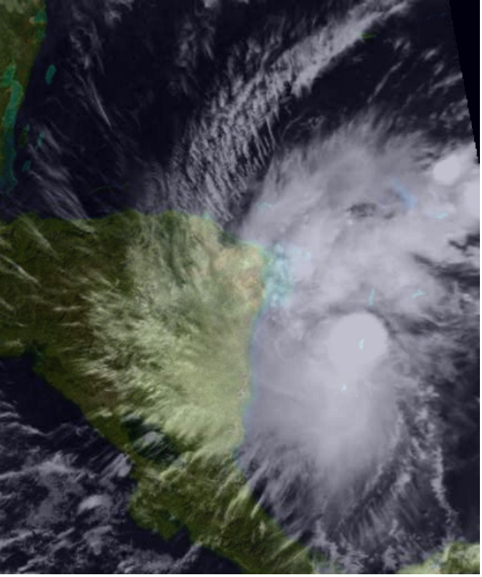
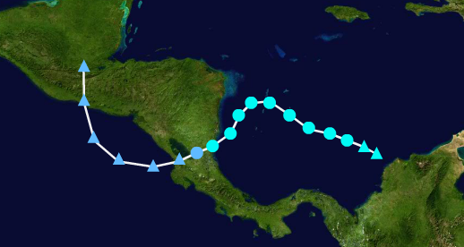
Early on September 28, an area of disturbed weather associated with a tropical gyre formed off the coast of Columbia, showing signs of organization. The disturbance rapidly organized into Tropical Storm Katia later that day, and Tropical Storm Warnings were issued for the coasts of Nicaragua and Costa Rica. The storm gradually moved towards the west-northwest, slowly intensifying. On September 29, the storm peaked, and curved southwestwards. Katia eventually made landfall on September 30, as a Tropical Storm with winds of approximately 45 mph. After making landfall, the storm rapidly degenerated into a remnant low in just the course of 12 hours. Katia's remnants would eventually move into the Pacific, and make Landfall in Mexico on October 2, bringing heavy rains to the area.
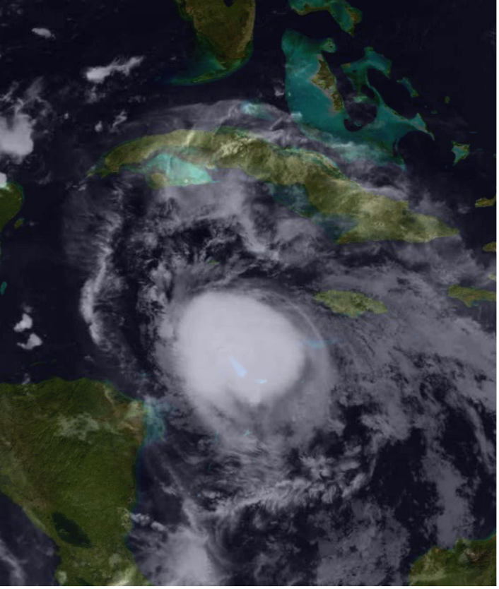
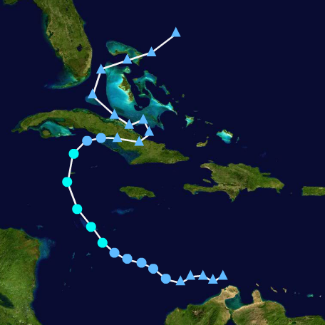
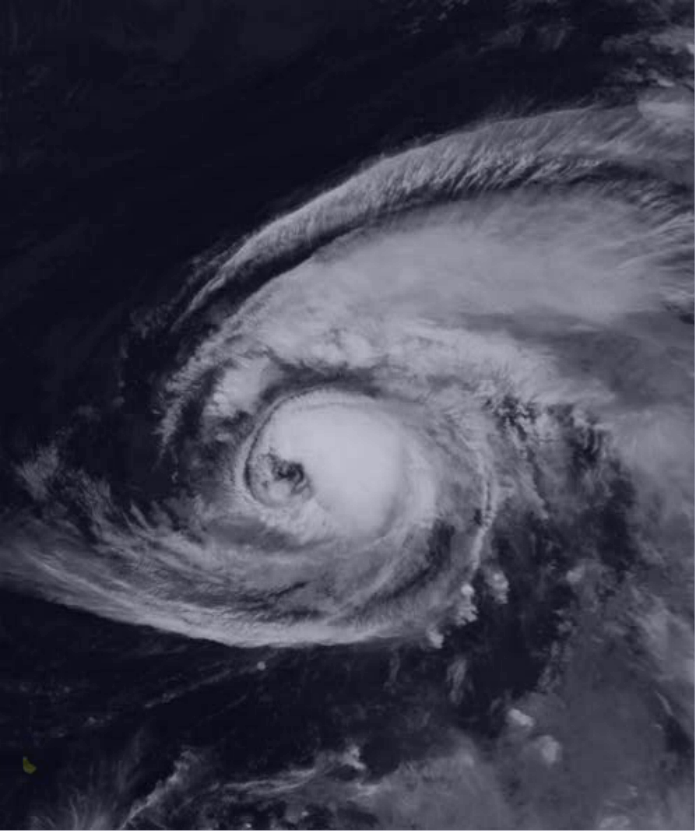
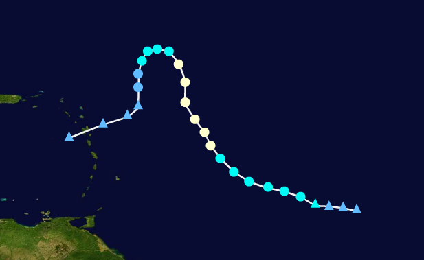
Hurricane Lee
| Category 3 hurricane (SSHWS) | |
  | |
| Duration | October 13 – October 24 |
|---|---|
| Peak intensity | 125 mph (205 km/h) (1-min) 944 mbar (hPa) |
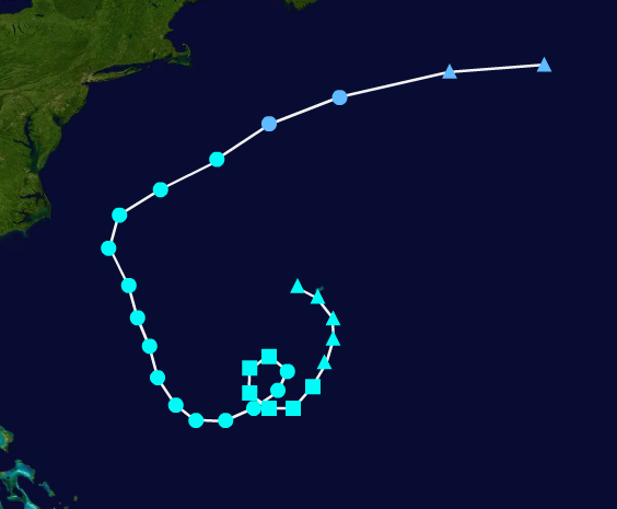
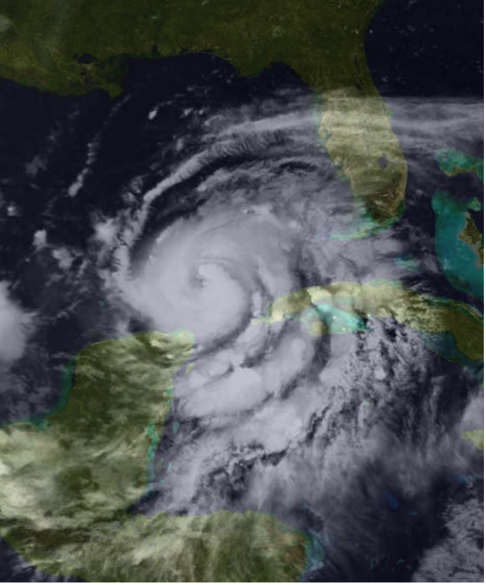
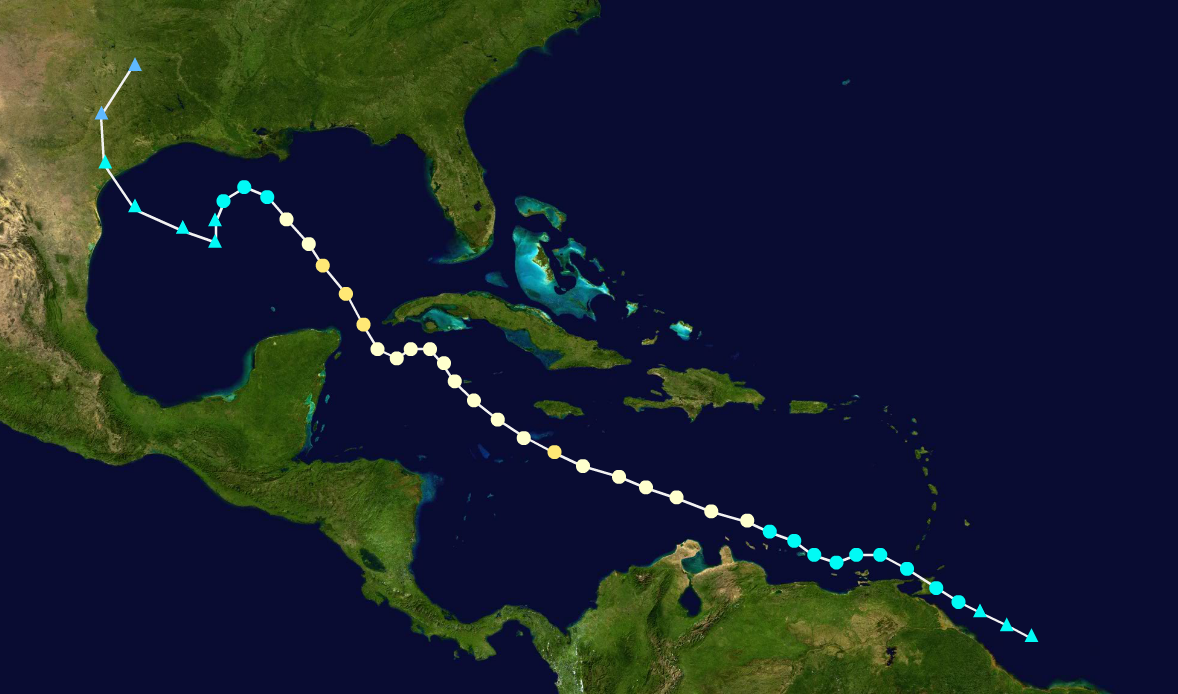
On October 12, a tropical wave formed a couple hundred miles northeast of the Windward Islands, and showed signs of organization. The disturbance gradually organized and was designated as a Tropical Storm on October 13, and received the name "Lee". The storm gradually tracked towards the northwest, struggling to intensify due to high amounts of wind-shear. The storm weakened into a Tropical Depression briefly on October 14, but re-intensified into a Tropical Storm six hours later. Lee then entered an area of favorable conditions, resulting in the storm strengthening into a Hurricane late on October 16. About 12 hours before making its first landfall, the storm intensified into a Category 2 Hurricane on October 18, but weakened back down slightly due to increasing interaction with land. Lee made landfall as a Category 1 on the Florida coast during the later hours of October 18. Lee weakened back into a Tropical Storm after making landfall. The storm then entered the Gulf of Mexico, and began to rapidly intensify. Lee became a Major Hurricane on October 20, and Tropical Storm and Hurricane warnings were issued across the Gulf coast states, ranging from Mississippi to Texas. Lee kept moving across the Gulf, dumping multiple inches of rain across the southeastern United States. The storm made its final landfall early on October 22 as a Category 2 Hurricane with winds of 110 mph. The storm then moved inland and rapidly weakened, becoming a Tropical Depression eighteen hours after making landfall. The storm continued to move over the central United States as a Depression, before eventually degenerating into a remnant low on October 24, and continued to dump rain across the United States.
Tropical Storm Margot
| Tropical storm (SSHWS) | |
  | |
| Duration | October 29 – November 2 |
|---|---|
| Peak intensity | 70 mph (110 km/h) (1-min) 995 mbar (hPa) |
A non-tropical low pressure system was located in the open Atlantic Ocean on October 28, with the system being forecast to eventually acquire subtropical characteristics. The low pressure system looped around in the north Atlantic and eventually became a Subtropical Storm on October 29, receiving the name "Margot". The storm gradually moved across the Atlantic, and became a Tropical cyclone on October 30. Over the next couple of days, the storm fluctuated in strength and continued drifting across the Atlantic. On November 1, the storm began to undergo an extratropical transition, and completed this process by November 2. The storm's remnants continued to move across the Atlantic, and eventually affected the British Isles and Ireland.
Tropical Storm Nigel
| Tropical storm (SSHWS) | |
  | |
| Duration | November 14 – November 16 |
|---|---|
| Peak intensity | 40 mph (65 km/h) (1-min) 1006 mbar (hPa) |
On November 13, a tropical wave was located in the Caribbean sea, several hundred miles west of the Lesser Antilles. The disturbance quickly organized and became a Tropical Depression on November 14. The storm eventually strengthened into a Tropical Storm later that day, and received the name "Nigel". Nigel continued to move across the Caribbean, struggling to intensify due to high-wind shear and overall unfavorable conditions. The storm degenerated into a Tropical wave by November 16, and continued to drift across the Caribbean.
Storm Names
The following names were used for named storms that formed in the North Atlantic in 2023. The names not retired from this list were used again in the 2029 season. This is the same list used for the 2017 season, with the exceptions of Harold, Idalia, Margot, and Nigel which replaced Harvey, Irma, Maria, and Nate respectively. Names that were not assigned are marked in gray.
|
|
|
Retirement
In April 2024, the World Meteorological Organization retired the names Franklin and Lee from its rotating name list due to the amounts of damages and deaths they caused. They were replaced with Finton and Logan for the 2029 season.
Season Effects
| Storm name |
Dates active | Storm category at peak intensity |
Max 1-min wind mph (km/h) |
Min. press. (mbar) |
Areas affected | Damage (USD) |
Deaths | |||
|---|---|---|---|---|---|---|---|---|---|---|
| Arlene | June 14 – June 19 | Category 1 hurricane | 90 | 991 | Bahamas, United States | $685 million | 3 | |||
| Bret | June 30 – July 2 | Tropical storm | 50 | 1002 | United States | Minimal | None | |||
| Three | July 9 – July 10 | Tropical depression | 35 | 1008 | Mexico | None | None | |||
| Cindy | July 17 – July 22 | Tropical storm | 65 | 992 | Bermuda | None | None | |||
| Don | August 2 – August 14 | Category 4 hurricane | 135 | 948 | Windward Islands | None | 1 | |||
| Emily | August 7 – August 10 | Tropical storm | 45 | 1004 | Cuba | Minimal | 1 | |||
| Franklin | August 25 – September 11 | Category 4 hurricane | 155 | 917 | Windward Islands, Puerto Rico, United States | $88.4 Billion | 56 | |||
| Gert | September 2 – September 7 | Category 1 hurricane | 85 | 982 | None | None | None | |||
| Harold | September 4 – September 7 | Category 1 hurricane | 75 | 990 | Azores, Portugal, France | $89 million | 4 | |||
| Idalia | September 10 – September 18 | Category 2 hurricane | 100 | 970 | Trinidad & Tobago, Jamaica, Cuba, United States | $201 million | 2 | |||
| Jose | September 14 – September 19 | Category 2 hurricane | 110 | 958 | Bermuda, Canada | Minimal | 8 | |||
| Katia | September 28 – September 30 | Tropical storm | 50 | 1000 | Costa Rica, Nicaragua | $77 million | None | |||
| Lee | October 13 – October 24 | Category 3 hurricane | 125 | 944 | Bahamas, United States | $17.6 billion | 178 | |||
| Margot | October 29 – November 2 | Tropical storm | 70 | 995 | Ireland, United Kingdom | Minimal | None | |||
| Nigel | November 14 – November 16 | Tropical storm | 40 | 1006 | None | None | None | |||
| Season aggregates | ||||||||||
| 15 systems | June 14 – November 16 | 155 | 917 | $106.85 billion | 253 | |||||