The 2023 Atlantic hurricane season saw above average activity. This active season contained 14 named storms, 8 hurricanes, and 5 major hurricanes. Normally, a hurricane season runs between June 1 and November 30, but as shown by Tropical Storm Arlene in May, tropical cyclones can form during any time of the year. For the first time since 2014, June did not feature any tropical activity. Hurricane Katia was a very long-lived hurricane, spanning 16 days. This was the longest lived Atlantic tropical cyclone since Jose of 2017. The active season was favored by ENSO neutral conditions.
There were many notable storms in 2023. In May, Tropical Storm Arlene quickly intensified to 50 mph winds and made landfall in Florida, causing scattered damage. In August, Hurricanes Don and Emily were both notable systems, with the former becoming a Category 3 Hurricane, and the latter a destructive Category 4 Hurricane that that tore up the east coast. In September, Hurricane Jose became a Category 5 hurricane, and caused extreme damage in the Dominican Republic despite remaining offshore, and Hurricane Katia was a powerful and long-lived hurricane. October featured a short-lived subtropical storm, Margot. In November, Hurricane Nigel caused disruption across Mexico and the United States.
Timeline[]

The season's activity was reflected with an above-average cumulative accumulated cyclone energy (ACE) rating of 141. ACE is, broadly speaking, a measure of the power of the hurricane multiplied by the length of time it existed, so storms that last a long time, like Katia, as well as particularly strong hurricanes, like Jose, have high ACEs.
Storms[]
|
Tropical Storm Arlene[]
| Tropical storm (SSHWS) | |
  | |
| Duration | May 11 – May 12 |
|---|---|
| Peak intensity | 50 mph (85 km/h) (1-min) 999 mbar (hPa) |
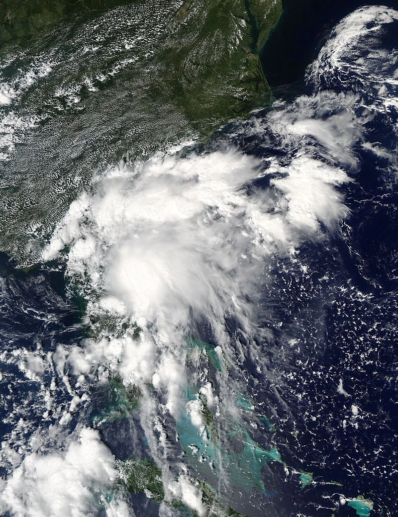
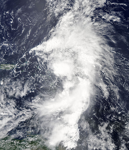
A non-tropical low developed over the Bahamas on May 9. In somewhat favorable conditions, it slowly began to consolidate, taking advantage of low wind shear, but only lukewarm waters. It approached Florida, and was invested as Potential Tropical Cyclone One. On May 11, recon observations confirmed that Tropical Depression One had formed, a couple miles off the coast of Florida. Twelve hours later, it intensified into Tropical Storm Arlene. Arlene was only able to intensify slightly before making landfall in Edgewater, Florida with winds of 50 mph. After landfall, Arlene quickly weakened and merged with a trough on May 12.
Hurricane Bret[]
| Category 1 hurricane (SSHWS) | |
  | |
| Duration | July 21 – July 24 |
|---|---|
| Peak intensity | 85 mph (140 km/h) (1-min) 980 mbar (hPa) |
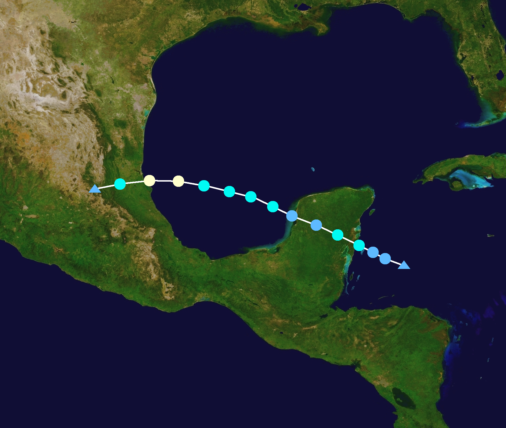
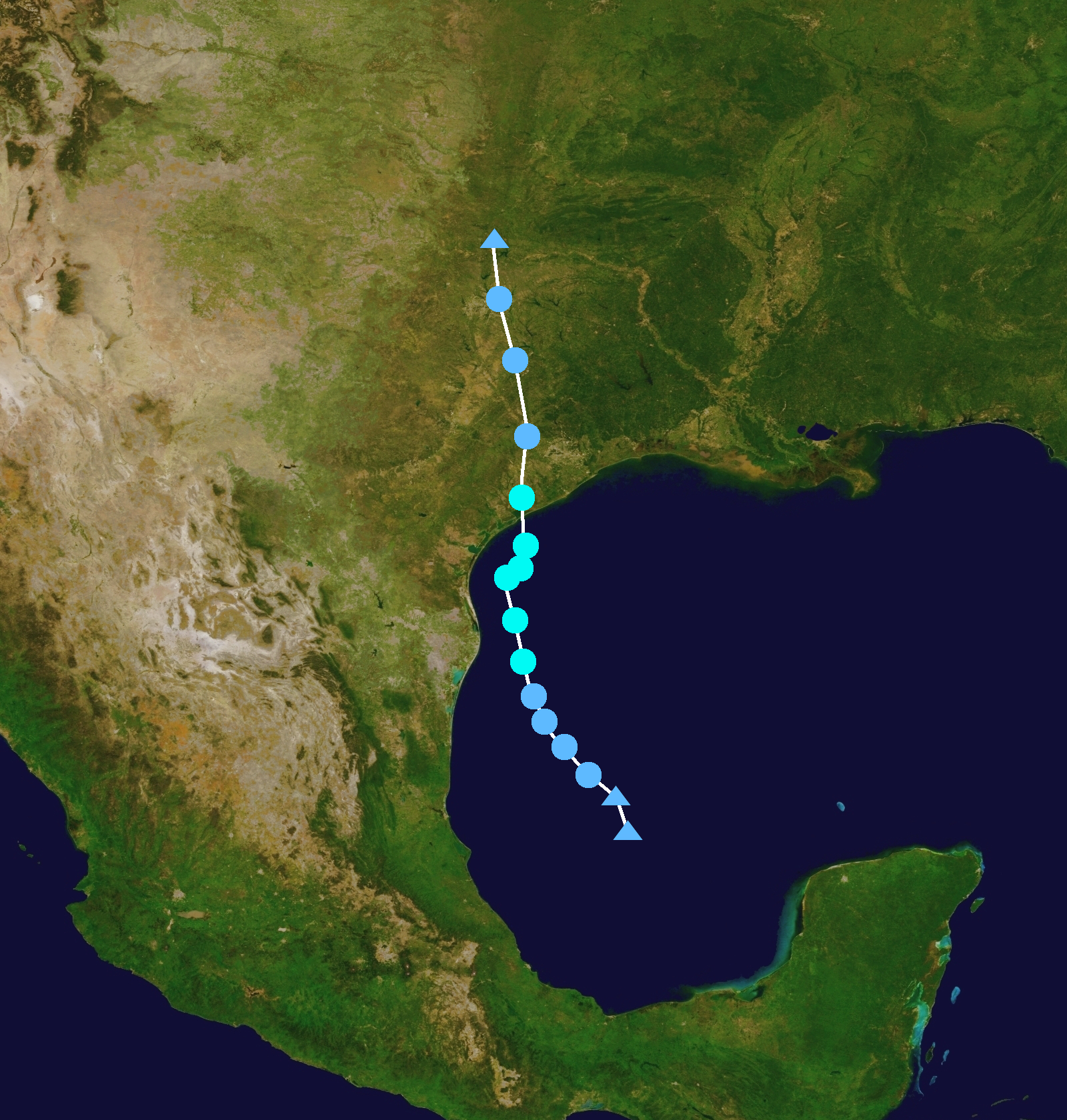
After an inactive June, a tropical wave emerged off the coast of Africa on July 10. It did not organize initially due to dry, stable air. It entered the Caribbean sea on July 16 and began to show some signs of organization. The NHC invested the wave and noted it could develop and threaten Mexico. On July 20, it was marked as PTC Two. But only twelve hours later, early on July 21, it developed into Tropical Depression Two. It quickly intensified into Tropical Storm Bret, and made landfall on the Yucatan Peninsula as a minimal tropical storm. It weakened over land, but it became more organized over the flat land. On July 22, Bret emerged into the Bay of Campeche, were favorable conditions allowed for intensification. On July 23, Bret developed an eye and intensified into a hurricane as it approached the coast of Mexico. That night, Bret made landfall in Veracruz, Mexico as a Category 1 hurricane. It weakened quickly, and the storm dissipated during the early hours of July 24.
Tropical Storm Cindy[]
| Tropical storm (SSHWS) | |
  | |
| Duration | August 5 – August 16 |
|---|---|
| Peak intensity | 65 mph (100 km/h) (1-min) 991 mbar (hPa) |
On August 1, a tropical wave emerged off the coast of Africa. It steadily developed in mostly favorable conditions, developing into Tropical Depression Three on August 5. Despite being predicted to intensify into a hurricane, moderate wind shear impeded Cindy's development, and it reached a peak of 65 mph on August 8, before beginning to weaken. It dissipated the next day due to increasing wind shear. The remnants slowly moved northwest before re-developing into a tropical cyclone as conditions became more favorable on August 10. In low wind shear, Cindy became much more organized as it accelerated northeast, reaching a secondary peak of 60 mph on August 15, as a primordial eye briefly formed. Cindy began to weaken due to colder SSTs, and the storm became extratropical on August 16.
Hurricane Don[]
| Category 3 hurricane (SSHWS) | |
  | |
| Duration | August 13 – August 21 |
|---|---|
| Peak intensity | 120 mph (195 km/h) (1-min) 949 mbar (hPa) |
On August 8, a tropical wave emerged off the coast of Africa. The wave moved across the tropical atlantic, and gained gale-force winds. Recon observations confirmed that it had developed into Tropical Storm Don on August 13. In an area of warm water and low wind shear, intensification seemed likely. Don developed a banding eye on August 14, and intensified into a hurricane that next day. Don curved to the northwest, and reached an initial peak of 105 mph on August 17. An eyewall replacement cycle began shortly after, but when this completed, Don began to intensify quicker. On August 18, Don intensified into the first major hurricane of the season, before peaking with winds of 120 mph and a pressure of 949 mbar, before colder waters induced weakening. Don accelerated northeast, and lost tropical characteristics on August 21. Don had no impacts on land during its lifetime.
Hurricane Emily[]
| Category 4 hurricane (SSHWS) | |
  | |
| Duration | August 18 – August 29 |
|---|---|
| Peak intensity | 145 mph (230 km/h) (1-min) 936 mbar (hPa) |
- Main article: Hurricane Emily
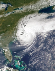
As part of an active August, another tropical wave entered the Atlantic on August 14. Somewhat favorable conditions allowed for slow development, and Tropical Depression Five formed on August 18. The following day, dvorak estimates led to an upgrade to Tropical Storm Emily. Emily tracked west, gradually intensifying. The storm intensified into a hurricane on August 22, when an eye began to clear out. Emily moved through the Lesser Antilles as a Category 1 hurricane, causing hurricane-force winds and high seas. Once north of the Antilles, however, very favorable conditions allowed Emily to begin rapid intensification as the eye cleared out. Emily was upgraded to a major hurricane on August 24, and reached peak intensity the next day, with maximum sustained winds of 145 mph. Increasing wind shear over the Bahamas caused Emily to fluctuate in strength, but it remained a strong hurricane. Emily paralleled the Bahamas as it hit a secondary peak of 140 mph, before weakening as it turned north. On August 28, as a weakening category 2 hurricane, Emily made landfall in Surf City, North Carolina with winds of 105 mph. Emily weakened quickly over land, and became post-tropical on August 29, as it moved over northern U.S and Canada.
Tropical Storm Franklin[]
| Tropical storm (SSHWS) | |
  | |
| Duration | August 25 – August 28 |
|---|---|
| Peak intensity | 45 mph (75 km/h) (1-min) 1006 mbar (hPa) |
A tropical wave emerged off the coast of Africa on August 17. Initially, due to proximity to Tropical Storm Emily, it failed to develop much. But when Emily moved further west, shear relaxed, and the wave developed into Tropical Storm Franklin on August 25, as it approached the Lesser Antilles. Franklin was expected to intensify to near hurricane status and approach Florida, but a low that formed after Emily passed forced Franklin south, and causing it to weaken. Franklin peaked with winds of 45 mph on August 26, before weakening to a Tropical Depression and making landfall in the Dominican Republic. The storm quickly dissipated on August 28. Overall, 12 people were killed, mostly in Haiti.
Hurricane Gert[]
| Category 3 hurricane (SSHWS) | |
  | |
| Duration | September 1 – September 6 |
|---|---|
| Peak intensity | 115 mph (185 km/h) (1-min) 964 mbar (hPa) |
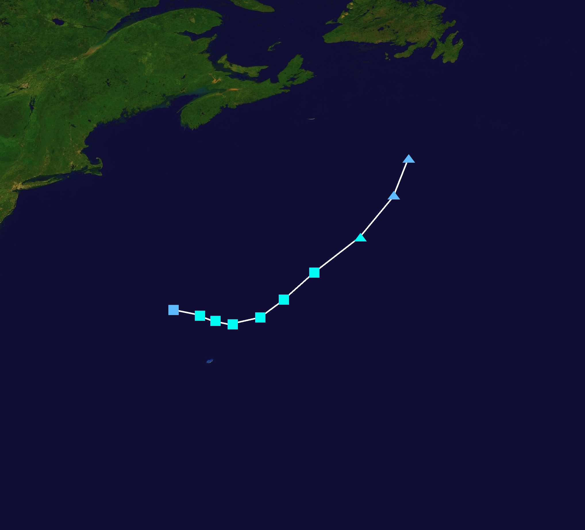
A tropical wave moved off the coast of Africa on August 20. No significant development occurred until August 30, when it began showcasing convective bursts near Puerto Rico. Because of this, it was monitored for potential development. On September 1, Tropical Depression Seven formed near the Bahamas. That night, it intensified into Tropical Storm Gert. Gert slowly moved across the warm Gulf stream, which allowed for fairly quick intensification. Gert became a hurricane on September 3, and rapidly intensified into a minimal Category 3 hurricane on September 4, and peaked with sustained winds of 115 mph. Shortly after peak, however, shear greatly increased, causing Gert to rapidly weaken as the eye vanished under the convection. Gert was declared post-tropical on September 6, and the remnants moved into Atlantic Canada.
Hurricane Harold[]
| Category 1 hurricane (SSHWS) | |
  | |
| Duration | September 8 – September 16 |
|---|---|
| Peak intensity | 80 mph (130 km/h) (1-min) 983 mbar (hPa) |
Yet another tropical wave entered the Atlantic on September 1. It developed into Tropical Storm Harold on September 8. Due to unfavorable wind shear, Harold was unable to intensify past moderate tropical storm status for several days, before weakening to a tropical depression on September 11. Shear decreased the next day though, and Harold re-intensified into a tropical storm. Harold intensified as it turned away, and it intensified into a hurricane on September 14, almost a week after forming. Despite waning convection, Harold hit peak intensify on September 15, with winds of 80 mph. Harold weakened as it accelerated northeast, making landfall in Riverport, Nova Scotia, as a tropical storm before becoming extratropical on September 16.
Tropical Storm Idalia[]
| Tropical storm (SSHWS) | |
  | |
| Duration | September 11 – September 13 |
|---|---|
| Peak intensity | 45 mph (75 km/h) (1-min) 1005 mbar (hPa) |
On September 9, a tropical wave moved off the coast of Africa. Unlike most of the systems that year, it was quick to develop, and was declared Tropical Depression Nine on September 11. It quickly intensified into Tropical Storm Idalia, and reached peak winds of 45 mph the next day, before running into strong wind shear. Idalia weakened to a Tropical Depression early on September 13, and dissipated later that night.
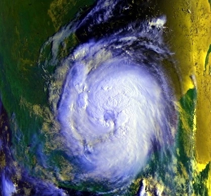
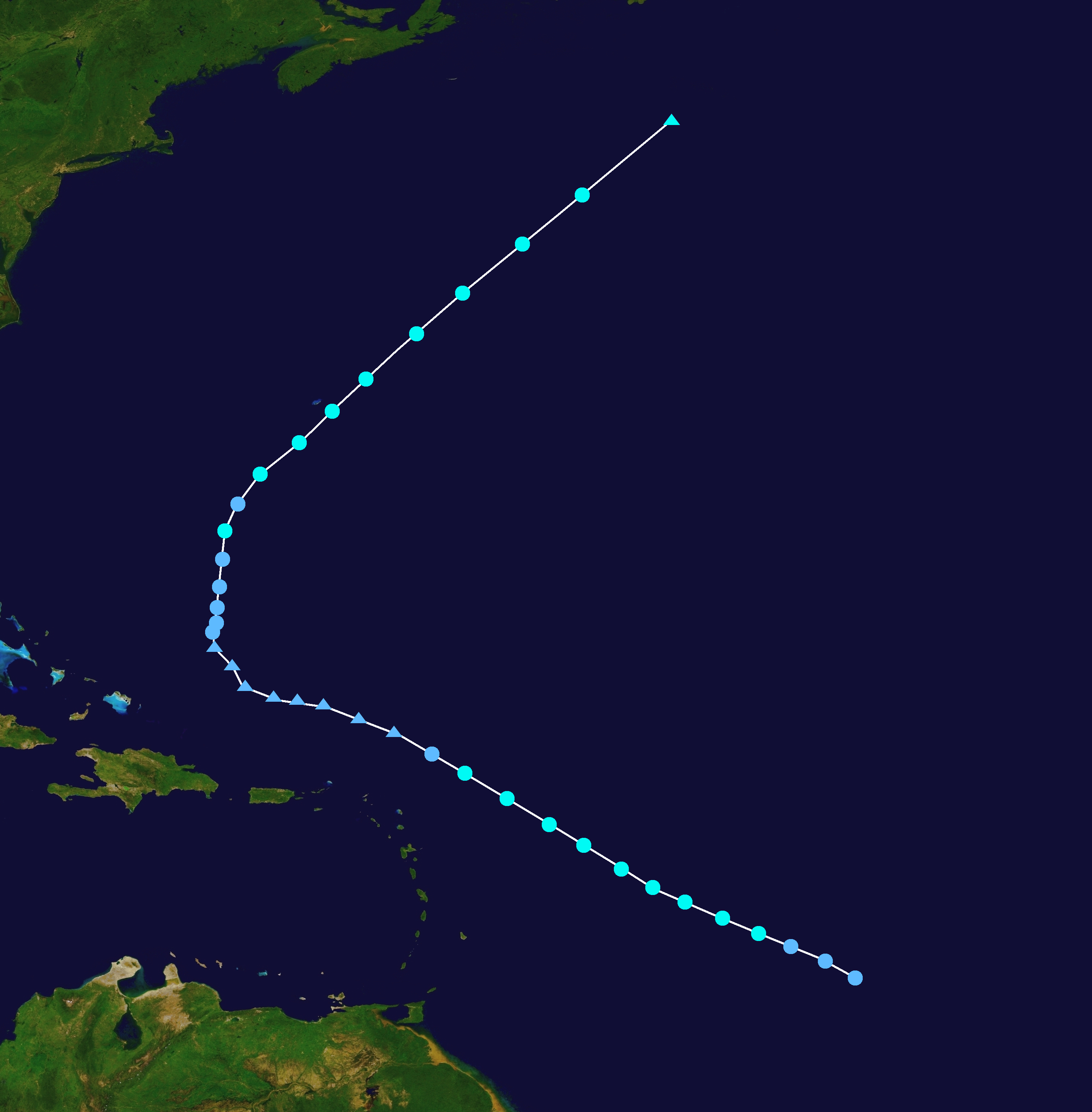
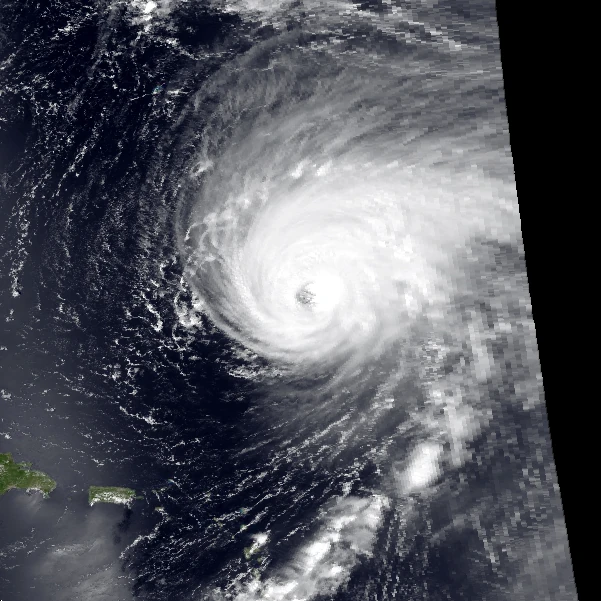
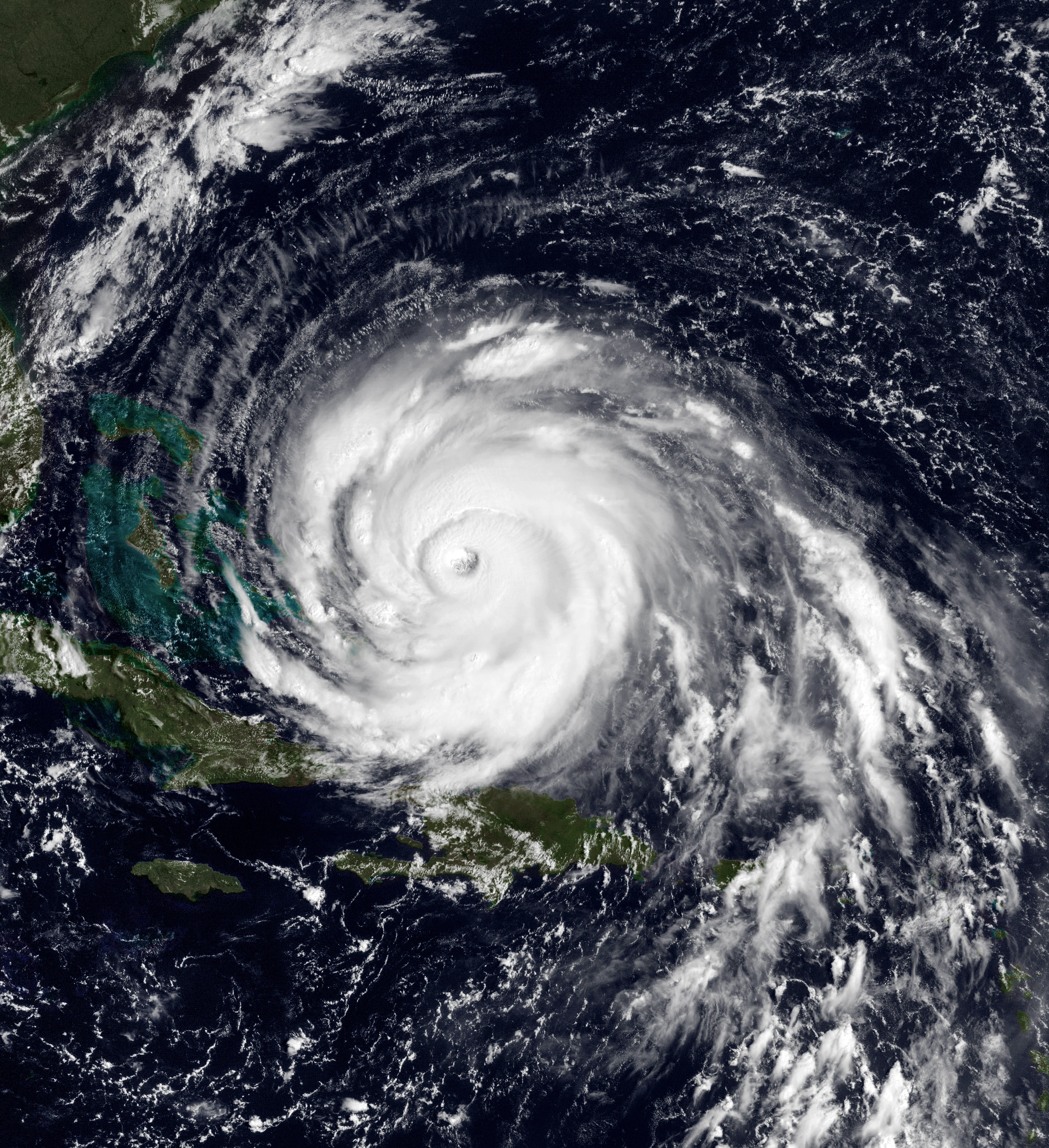
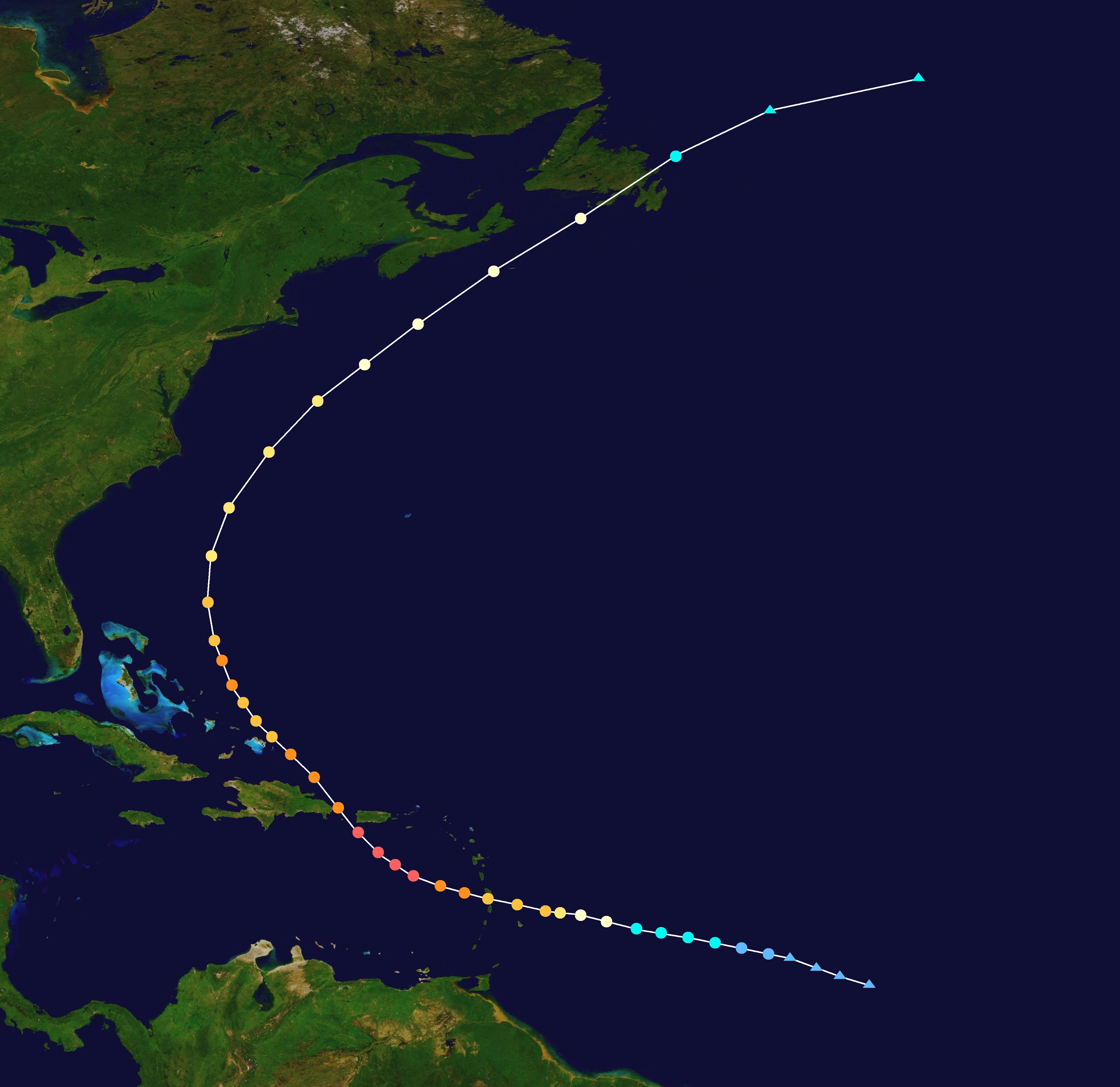
Hurricane Jose[]
| Category 5 hurricane (SSHWS) | |
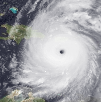  | |
| Duration | September 16 – September 26 |
|---|---|
| Peak intensity | 160 mph (260 km/h) (1-min) 928 mbar (hPa) |
- Main article: Hurricane Jose
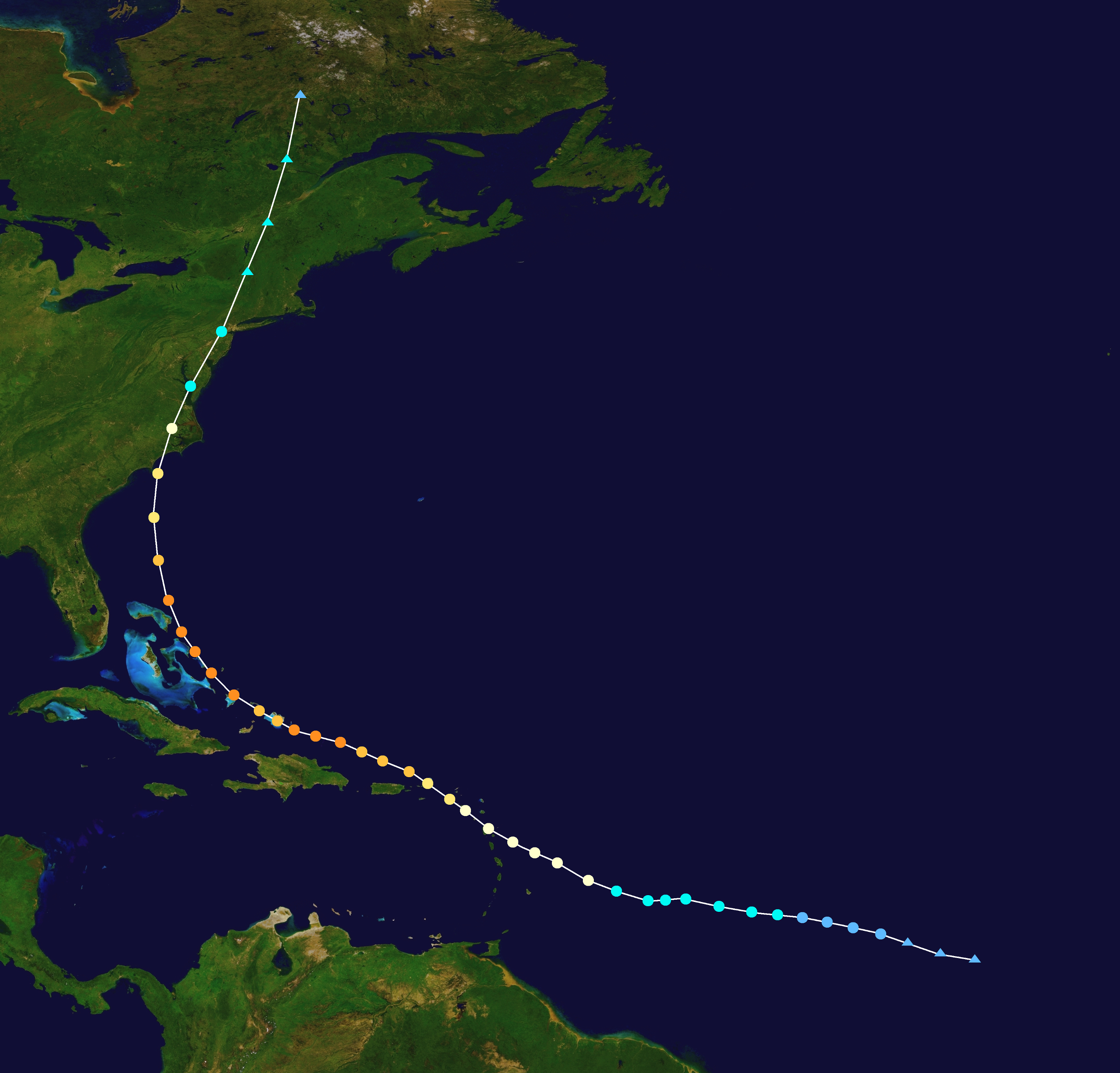
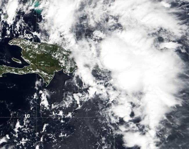
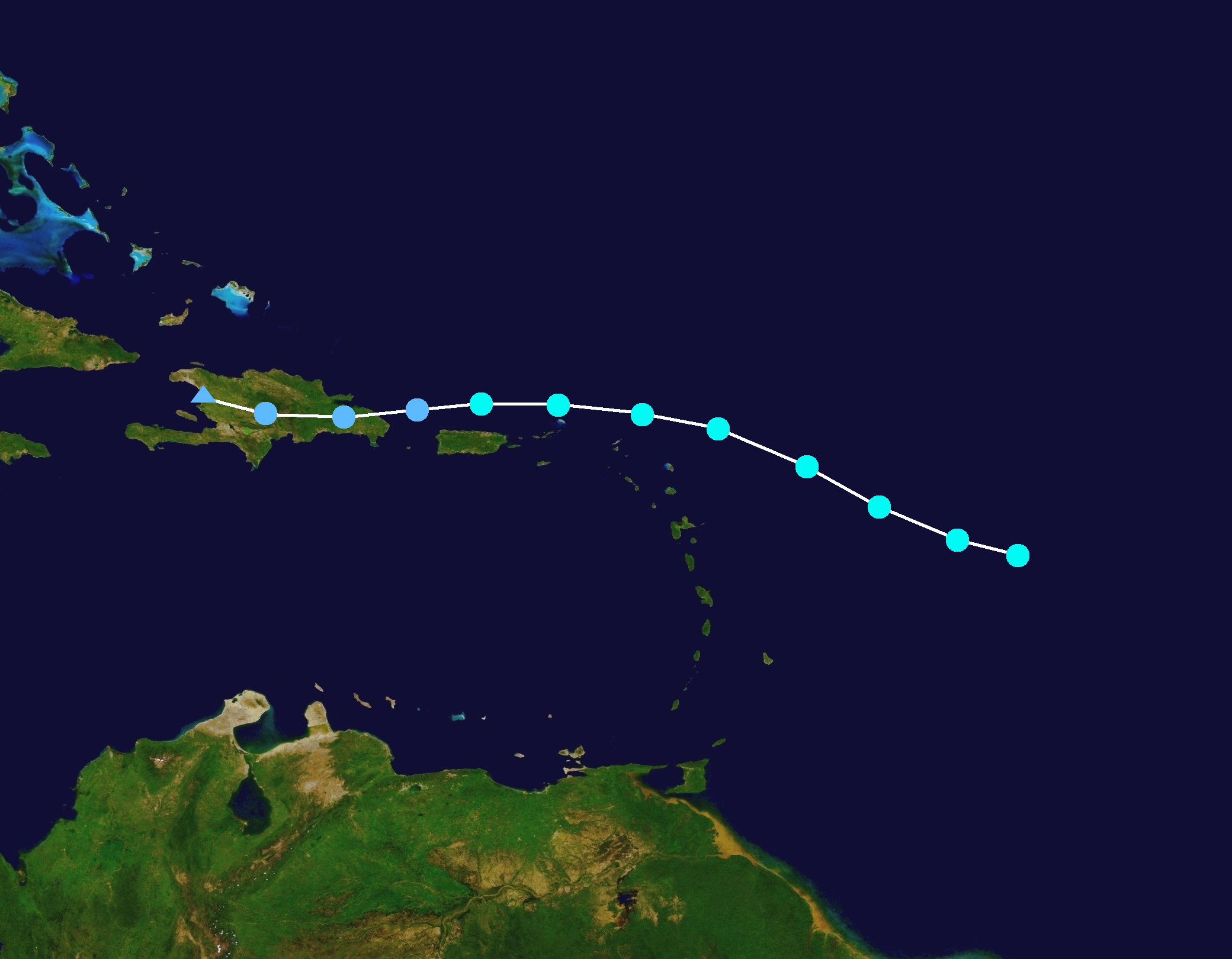
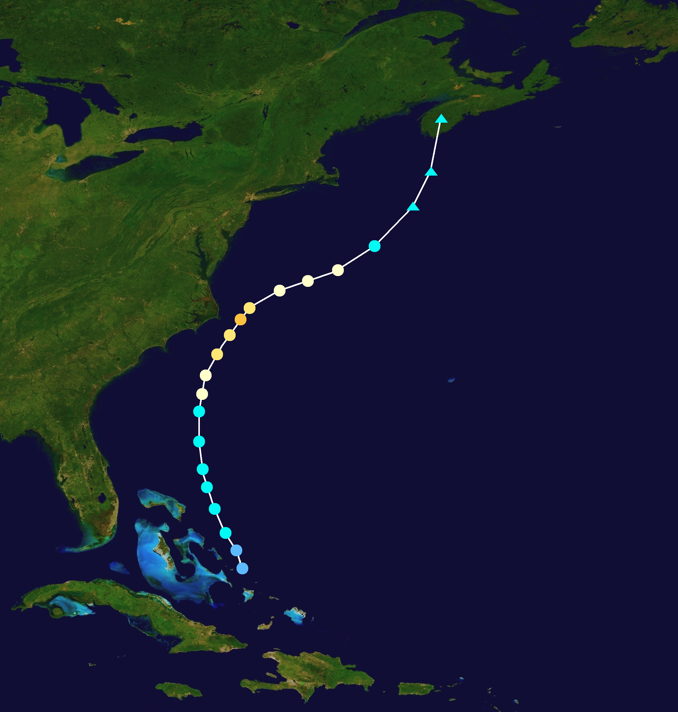
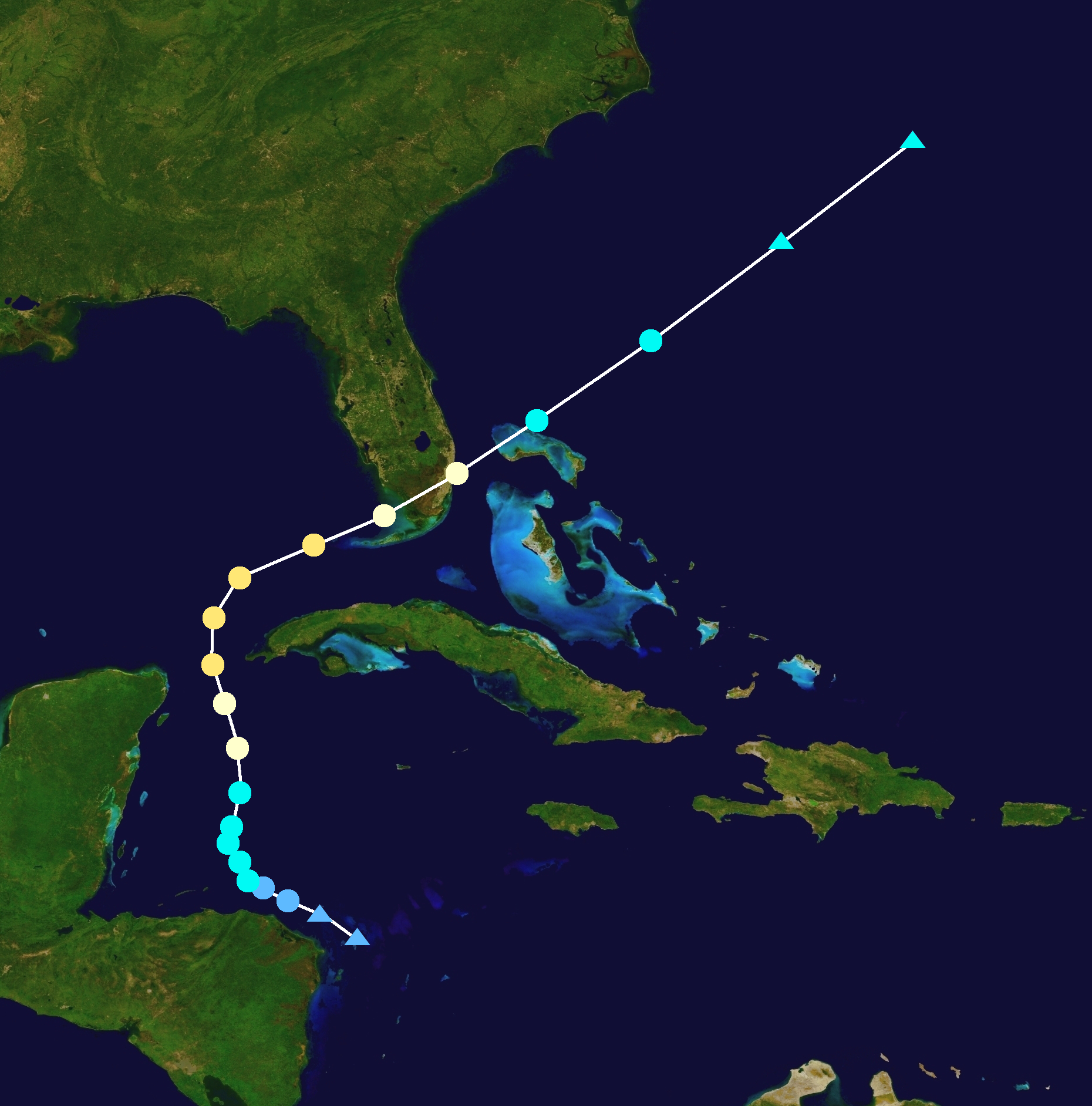
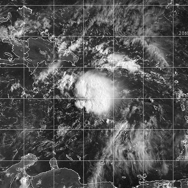
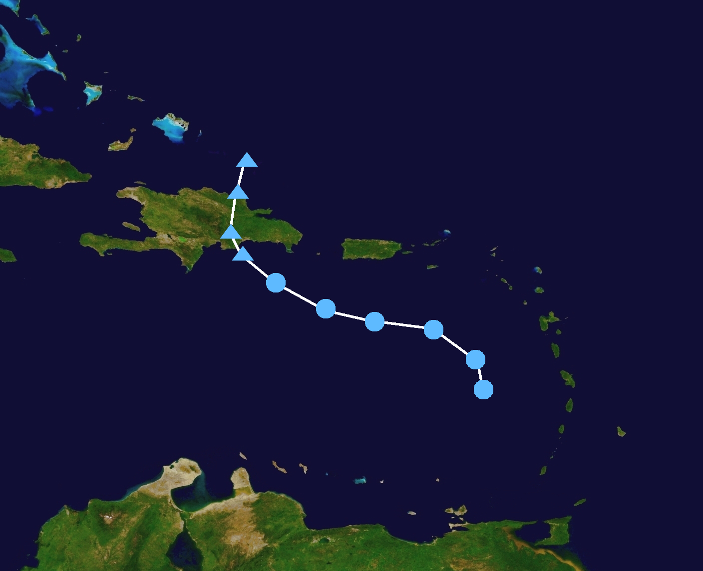
On September 11, a powerful tropical wave emerged off the African coast. In favorable conditions, it developed into Tropical Depression Ten on September 16. Quickly intensifying, it became a tropical storm that day, and was named Jose. Jose intensified quickly due to low wind shear and warm waters, and was upgraded to a hurricane on September 18. Rapid intensification ensued as Jose approached the Leeward Islands. Jose entered the Caribbean sea after it intensified into a major hurricane, and intensified to Category 5 status on September 20, making it the strongest of the season. At peak intensity, Jose's western eyewall came ashore in the Dominican Republic, but did not make landfall. Interaction with this land caused Jose's eye to wane, resulting in weakening. Jose slowly recurved away from the U.S, due to a high pressure area. It accelerated east, and Jose made landfall on Newfoundland on September 26, as an 80 mph hurricane. Twelve hours later, Jose was post-tropical.
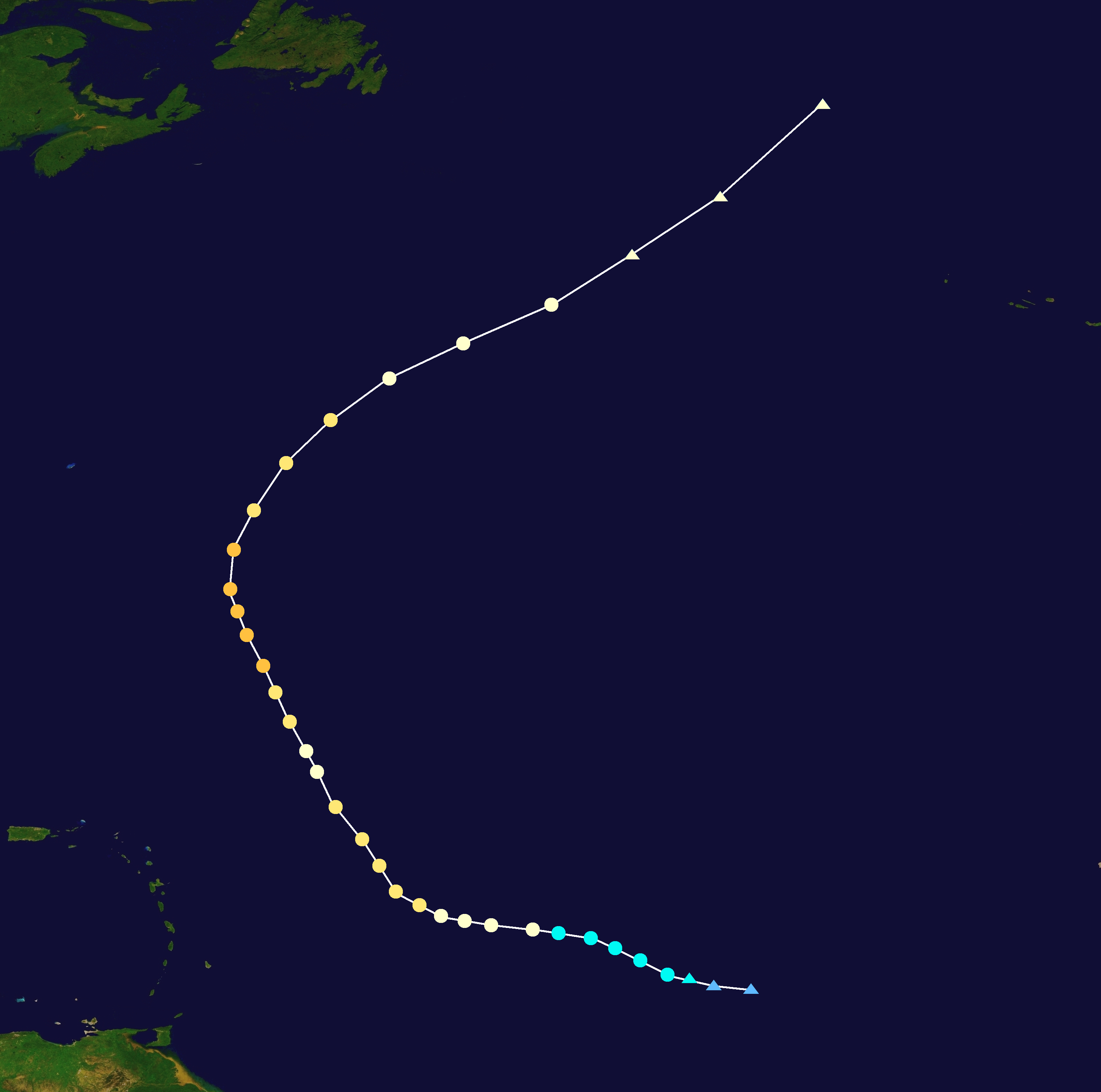
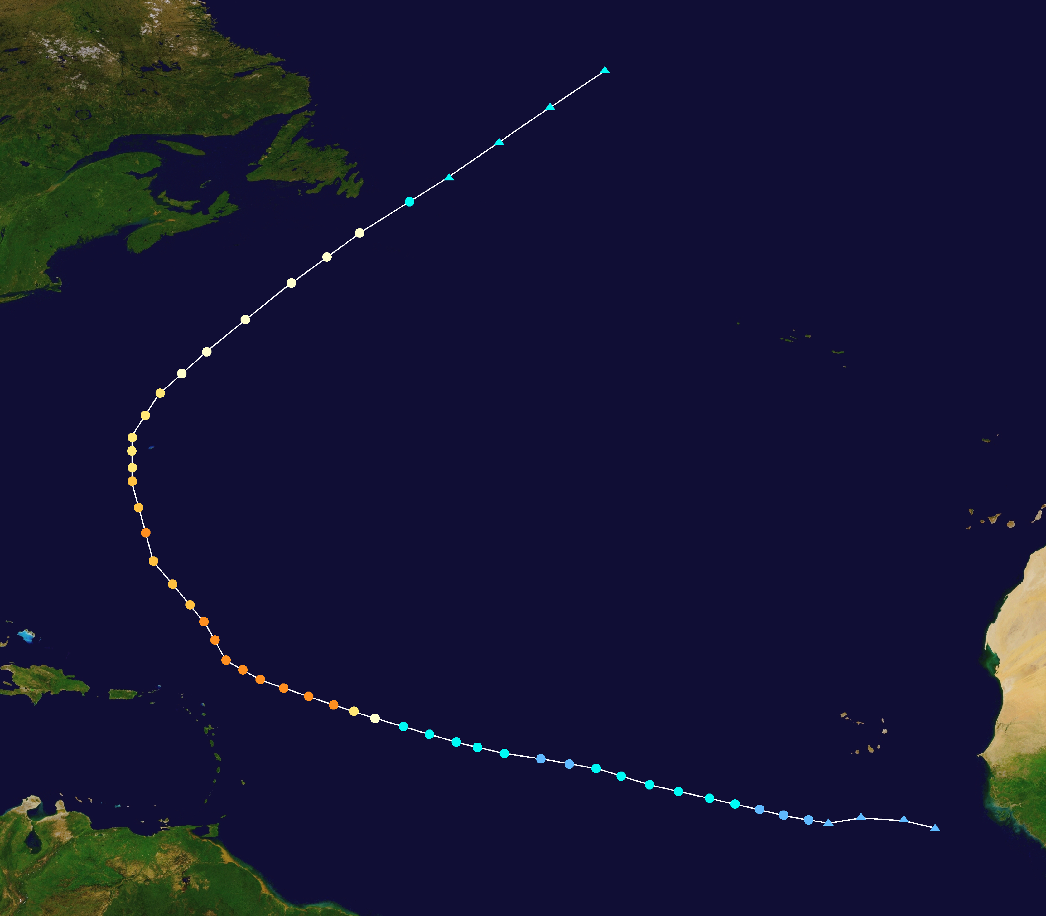
Hurricane Katia[]
| Category 4 hurricane (SSHWS) | |
  | |
| Duration | September 21 – October 5 |
|---|---|
| Peak intensity | 150 mph (240 km/h) (1-min) 933 mbar (hPa) |
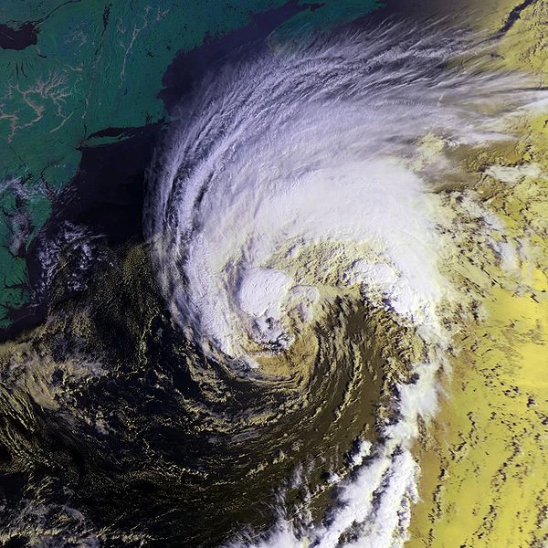
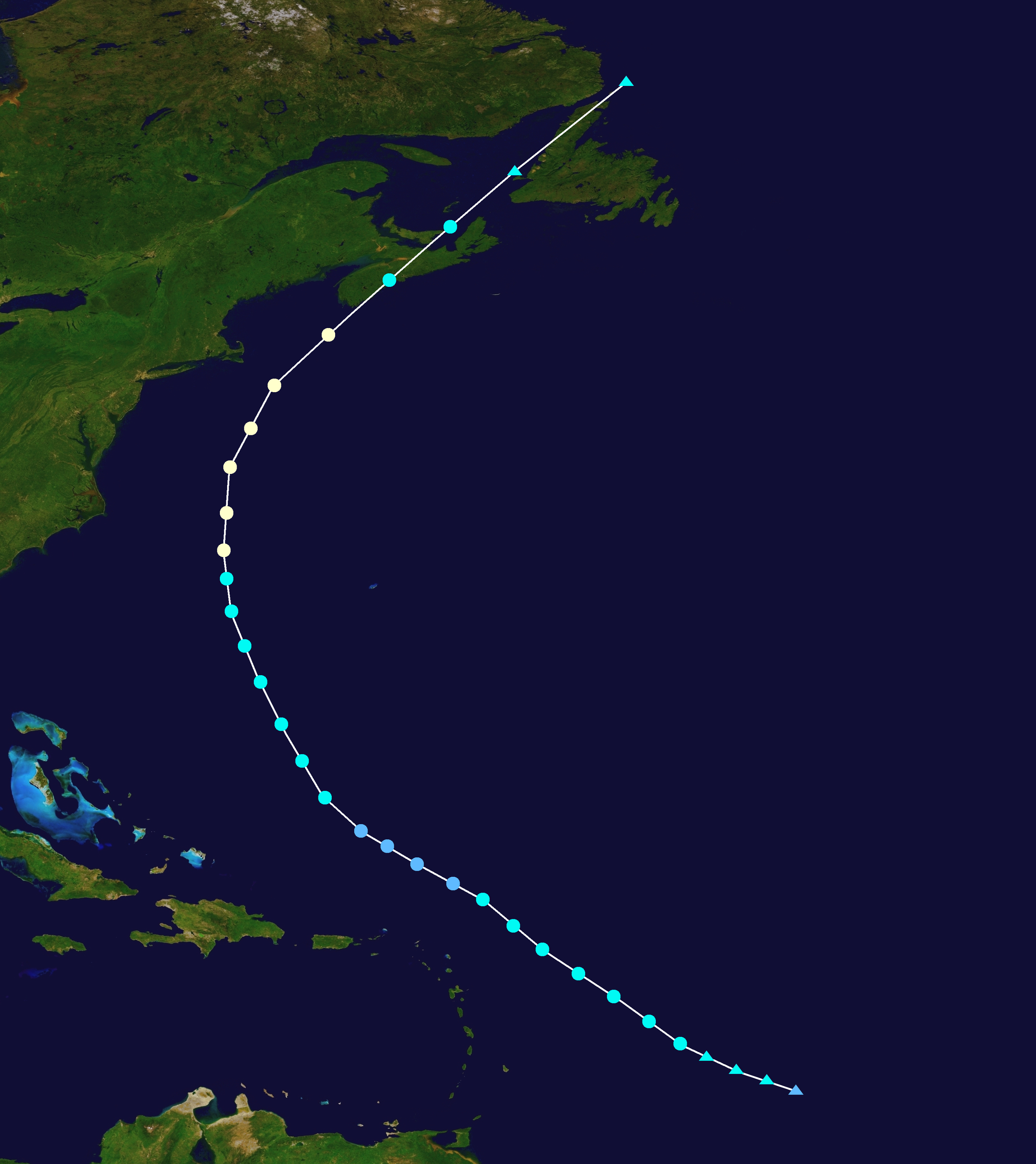
A tropical wave emerged off the coast of Africa on September 19. A few days later, it developed into Tropical Storm Katia. For several days, Katia struggled against wind shear, and was not able to intensify much. However, shear became more favorable on September 24, and Katia intensified, becoming a hurricane on September 26. From here, it rapidly intensified, becoming a Category 4 hurricane on September 28. It reached peak intensity on September 30 as it turned north, with winds of 150 mph. Katia slowed down as steering currents briefly collapsed, but it moved northeast on October 2. Katia accelerated away from land, approaching Newfoundland on October 5 before becoming post-tropical that day.
Tropical Storm Lee[]
| Tropical storm (SSHWS) | |
  | |
| Duration | September 26 – September 30 |
|---|---|
| Peak intensity | 60 mph (95 km/h) (1-min) 1000 mbar (hPa) |
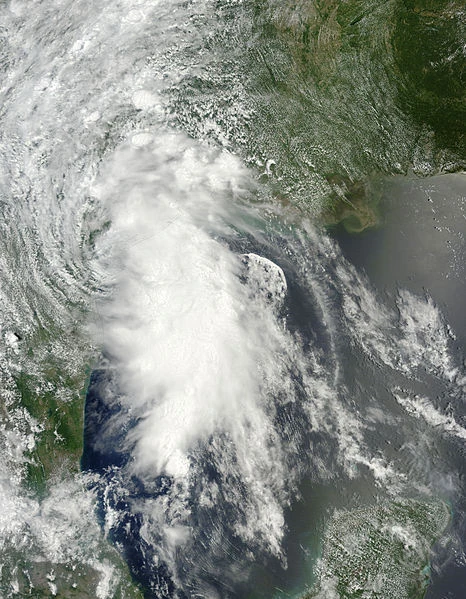
A large gyre formed across the Caribbean on September 23. It spawned two systems. The first moved into the Pacific and developed into Tropical Storm Norma. The other system moved north, into the Gulf of Mexico. It gradually developed into a tropical cyclone, and was declared Tropical Depression Twelve on September 26. The following afternoon, it was upgraded to Tropical Storm Lee. Despite some wind shear, Lee was able to intensify gradually. Lee exhibited unusual movement traits on September 28, as it abruptly turned southeast, than east, than north again. Lee reached peak intensity, with winds of 60 mph around this time. Lee weakened slightly before making landfall in the Aransas National Wildlife Refuge in Texas, with winds of 50 mph on September 29. Lee moved inland, and dissipated on September 30.
Subtropical Storm Margot[]
| Subtropical storm (SSHWS) | |
  | |
| Duration | October 15 – October 17 |
|---|---|
| Peak intensity | 50 mph (85 km/h) (1-min) 996 mbar (hPa) |
An extratropical low began to organize over the northern Atlantic on October 11. It moved erratically over several days, before showing signs of development. It developed into Subtropical Depression Thirteen on October 15, but was not initially declared until the next day, when it had intensified into a subtropical storm and was named Margot. Margot reached peak winds of 50 mph before weakening due to cooler waters. A disorganized Margot became post-tropical on October 17, before dissipating quickly over the open Atlantic.
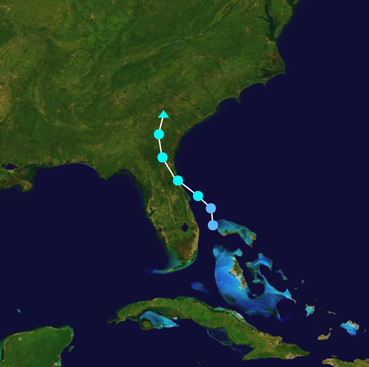
Hurricane Nigel[]
| Category 2 hurricane (SSHWS) | |
  | |
| Duration | October 29 – November 3 |
|---|---|
| Peak intensity | 105 mph (165 km/h) (1-min) 965 mbar (hPa) |
A low pressure area developed in the Caribbean sea on October 25. It was monitored for tropical development due to mostly favorable conditions. A Tropical depression formed on October 29, and it quickly intensified into Tropical Storm Nigel. Nigel gradually intensified and moved north, intensifying into a hurricane on October 31. Nigel grew in size as it intensified, and peaked on November 1, with winds of 105 mph. Nigel then moved east, weakening due to wind shear, and made landfall in the Everglades National Park as a strong Category 1 hurricane. It crossed over Miami-Dade County before re-emerging into the Atlantic on November 3. Nigel became post-tropical later that day, and eventually became extratropical.
Tropical Depression Fifteen[]
| Tropical depression (SSHWS) | |
  | |
| Duration | November 14 – November 16 |
|---|---|
| Peak intensity | 35 mph (55 km/h) (1-min) 1008 mbar (hPa) |
A weak tropical wave moved off the coast of Africa on November 6. As it approached the Leeward Islands, it merged with an area of low pressure and began to rapidly develop. On November 14, Tropical Depression Fifteen formed. It was thought that the depression would intensify into a Tropical Storm, but wind shear, and the Depression's speed prevented much intensification. It dissipated on November 16. The remnants brought heavy rains to Hispaniola.
Season Effects[]
| Storm name |
Dates active | Storm category at peak intensity |
Max 1-min wind mph (km/h) |
Min. press. (mbar) |
Areas affected | Damage (USD) |
Deaths | |||
|---|---|---|---|---|---|---|---|---|---|---|
| Arlene | May 11 – May 12 | Tropical storm | 50 | 999 | Bahamas, United States | 15 | None | |||
| Bret | July 21 – July 24 | Category 1 hurricane | 85 | 980 | Central America, Mexico | 90.2 | 9 | |||
| Cindy | August 5 – August 16 | Tropical storm | 65 | 991 | United States, Bermuda | Minimal | 1 | |||
| Don | August 13 – August 21 | Category 3 hurricane | 120 | 949 | None | None | None | |||
| Emily | August 18 – August 29 | Category 4 hurricane | 145 | 936 | Lesser Antilles, Puerto Rico, Bahamas, United States, Canada | 8135 | 29 | |||
| Franklin | August 25 – August 28 | Tropical storm | 45 | 1006 | Lesser Antilles, Puerto Rico, Hispaniola | 7.3 | 12 | |||
| Gert | September 1 – September 6 | Category 3 hurricane | 115 | 964 | Bahamas, United States, Canada | 171.5 | 6 | |||
| Harold | September 8 – September 16 | Category 1 hurricane | 80 | 983 | Lesser Antilles, United States, Canada | 80 | 2 | |||
| Idalia | September 11 – September 13 | Tropical storm | 45 | 1005 | None | None | None | |||
| Jose | September 16 – September 26 | Category 5 hurricane | 160 | 928 | Leeward Islands, Puerto Rico, Dominican Republic, Bahamas, United States, Canada | 985.7 | 451 | |||
| Katia | September 21 – October 5 | Category 4 hurricane | 150 | 933 | United States, Bermuda | 45 | None | |||
| Lee | September 26 – September 30 | Tropical storm | 60 | 1000 | United States, Mexico | 78.8 | 5 | |||
| Margot | October 15 – October 17 | Subtropical storm | 50 | 996 | Bermuda | None | None | |||
| Nigel | October 29 – November 3 | Category 2 hurricane | 105 | 965 | Nicaragua, Honduras, Mexico, United States, Bahamas | 365 | 19 | |||
| Fifteen | November 14 – November 16 | Tropical depression | 35 | 1008 | Dominican Republic, Haiti | Minimal | 5 | |||
| Season aggregates | ||||||||||
| 15 systems | May 11 – November 16 | 160 | 928 | $9.97 Billion | 539 | |||||
Storm Names[]
The following names were used for named storms in the North Atlantic in 2023. Names that were not used are marked in gray. This is the same list used in the 2017 season, with the exception of Harold, Idalia, Margot, and Nigel, which replaced Harvey, Irma, Maria, and Nate, respectively. These names were used for the first time this year.
|
|
|
Retirement[]
On April 9, 2024, at the 46th Session of the World Meteorological Organization's Regional Association Hurricane Committee, the WMO retired the names Emily and Jose from its rotating name lists. They were replaced with Emma and Justin for the 2029 Atlantic hurricane season.