This page will feature the first 200 storms of the 82590 Atlantic Hurricane Season
Hypercanes, Megacanes, Infinite storms and Mini Black Holes are all welcome!!!
Storms[]
Hurricane Adam[]
| Category 1 hurricane (SSHWS) | |
 | |
| Duration | January 1 – January 5 |
|---|---|
| Peak intensity | 85 mph (140 km/h) (1-min) 980 mbar (hPa) |
Hurricane Adam were 2 weak tropical waves coming off from Senegal and Togo. They then merged, making a tropical storm on January 1. It went over warm waters of 80 °F and developed into a Category 1 hurricane. It then weakened into a tropical depression, and then it went extratropical, and it dissipated while being extratropical in January 5.
Tropical Storm Betsy[]
| Tropical storm (SSHWS) | |
| | |
| Duration | January 1 – January 3 |
|---|---|
| Peak intensity | 50 mph (85 km/h) (1-min) 1003 mbar (hPa) |
Betsy was a weak tropical wave coming off from the Bahamas that then developed into a tropical storm in January 2. The next day, it dissipated.
Tropical Storm Cheren[]
| Tropical storm (SSHWS) | |
| | |
| Duration | January 1 – January 2 |
|---|---|
| Peak intensity | 40 mph (65 km/h) (1-min) 1005 mbar (hPa) |
Cheren was a weak tropical wave that became a weak tropical storm for 1 hour and then it dissipated on January 2.
Hurricane Dulcibella[]
| Category 2 hurricane (SSHWS) | |
| | |
| Duration | January 2 – January 7 |
|---|---|
| Peak intensity | 110 mph (175 km/h) (1-min) 969 mbar (hPa) |
Dulcibella was a extratropical cyclone that developed into a tropical cyclone, and then it went over warm waters and developed into a Category 2 hurricane on January 5. It then went north on January 6th and dissipated while being a subtropical cyclone on January 7.
Tropical Storm Eren[]
| Tropical storm (SSHWS) | |
| | |
| Duration | January 2 – January 5 |
|---|---|
| Peak intensity | 65 mph (100 km/h) (1-min) 1001 mbar (hPa) |
Eren was a strong tropical storm that formed from a subtropical cyclone that then developed into a tropical cyclone. It went over warm waters for an hour and almost became a Hurricane on January 3. It then weakened on January 5th and dissipated shortly after that.
Hurricane Francella[]
| Category 8 hurricane | |
| | |
| Duration | January 2 – February 17 |
|---|---|
| Peak intensity | 355 mph (570 km/h) (1-min) 787 mbar (hPa) |
Francella was a devastating hurricane that formed from a very strong tropical wave coming off from Togo on January 1. 10 days later, it developed to a Category 1 hurricane. It passed as a Category 3 hurricane over Cuba on February 2. It then went northwest to the Bahamas, as a Category 8 hurricane. It then dissipated west of the Azores on February 17.
Hurricane Gregory[]
| Category 10 hurricane | |
| | |
| Duration | January 3 – February 27 |
|---|---|
| Peak intensity | 455 mph (730 km/h) (1-min) 747 mbar (hPa) |
Gregory was a tropical storm coming from Cuba, that then went over a volcanic eruption and developed into a Category 10 hurricane. It passed over Haiti and destroyed everything. It weakened into a Category 2 and hit New York on February 18. It then weakened into a meaningless extratropical storm the size of a whale in February 27.
Hypercane Hyce[]
| Hypercane | |
 | |
| Duration | 17 March – 28 March (Exited basin) |
|---|---|
| Peak intensity | 865 mph (1390 km/h) (1-min) 721 mbar (hPa) |
Hypercane Hyce formed from a tropical wave coming off the coast of west Africa on 16 March. The tropical wave then went over 93 °F sea surface temperatures and rapidly developed into Tropical Storm Hyce. The tropical storm located in a extremely favorable environment rapidly became a Category 8 hurricane near the Leeward Islands on 20 March, Hyce crossed the Leeward Islands as a Category 8 hurricane with winds of 360 mph. The hurricane then went over a patch of 124 °F sea surface temperatures and further strengthened to a hypercane on 24 March. Hypercane Hyce then slammed into Central America with winds of 865 mph late on 28 March. The hypercane then crossed into the East Pacific still as a 610 mph hypercane.
Hurricane Injima[]
| Category 5 hurricane (NHC) | |
  | |
| Duration | March 28 – April 13 |
|---|---|
| Peak intensity | 195 mph (315 km/h) (1-min) 888 mbar (hPa) |
Hurricane Injima became a category 5 hurricane just south of the Azores, breaking numerous records.
On March 27, a tropical disturbance moved onto the Atlantic with little probability of forming into a tropical cyclone. On March 28, it developed into a Tropical Depression. On the 29th, it intensified into Tropical Storm Injima. A few days later, it achieved major hurricane status as a 120 mph category 3 off of Florida. Then an unexpected front moved off the East Coast, pushing the storm north-east. On April 9, the storm became a category 5 south of the Azores. On April 10, it slammed into Portugal as a full blown category 4, destroying everything on the coast with a 25 foot storm surge, drowning 429 people, and injuring hundreds of thousands more. It then turned west-northwest. It then dissipated on April 14.
Tropical Storm Jean[]
| Tropical storm (NHC) | |
| (NHC) | |
 | |
| Duration | 30 March – 4 April |
|---|---|
| Peak intensity | 70 mph (110 km/h) (1-min) 995 mbar (hPa) |
Tropical Storm Jean formed as a small disturbance near the Virgin islands. It started moving south and becoming stronger, until it became a tropical storm near Puerto Rico. It passed through east of Puerto Rico and became a depression. Later, near Aruba, it became extratropical (EX). Then, it finally dissipated again, near Aruba.
Infinite Storm Kylie[]
| Infinite Storm | |
| | |
| Duration | April 3 – April 16 |
|---|---|
| Peak intensity | 17265 mph (27780 km/h) (1-min) -304.1 mbar (hPa) |
Infinite Storm Kylie was a destructive storm of the season. On April 3, a depression rapidly formed, strengthening to Tropical Storm Kylie only two minutes later. The storm then went over high temperature waters of 120 degrees, strengthening to a hypercane quickly on April 4. The storm then stalled over the patch of water, becoming a superstorm on April 8. The system then began to move towards Florida, making landfall there at peak intensity of 17265 miles per hour, completely demolishing Florida (however, some areas were rebuilt later) and then it went on, weakening to a hypercane as it made landfall in Louisiana, still tracking northwest. The system went over land and remained as a weak hypercane, causing maximum damage. The system then went to the Rockies, where the system rapidly weakened and dissipated on April 30
Post-Analysis: Kylie was found to have been the strongest storm of the season in terms of pressure. Tetra later in the season acquired higher wind speeds.
Hurricane Landon[]
| Category 8 hurricane | |
| | |
| Duration | April 18 – May 7 |
|---|---|
| Peak intensity | 395 mph (640 km/h) (1-min) 818 mbar (hPa) |
Hurricane Landon, although not the strongest storm of the season, caused massive destruction across the U.S. Coast upon making landfall. On April 18, a rapidly-intensifying system formed near Cape Verde. Because of almost no wind shear and water temperatures near 115º Fahrenheit, the depression became a Category 2 hurricane named Landon within hours. Over the next week, Landon reached speeds near 190 MPH, exceeding C5 status. Continuing on a track Northwest across the Northern Atlantic, Landon remained annular until April 28, after colliding with an extratropical frontal system moving across the Northern Atlantic. On April 29, wind speeds reached 260 MPH within the storm's core as the size of the storm exploded. By now, the storm stretched along from South Carolina to New Jersey. That day, the storm hit Bermuda, leaving nothing left as 70-foot waves plunged the island deep underwater. The next day, Landon peaked at 395 MPH. People East of the Appalachian Mountains were evacuated to the Western United States, Mexico, or Canada. On May 2, Landon officially made landfall; the core of the storm over Richmond, VA. Landon plowed across the East Coast, wiping out entire cities. New York City, in New York State, was obliterated off the map by 80-foot waves stirred up by Landon's low pressure and high winds, even though the outer bands of Landon never even touched New York State! The U.S. lost as much as 300-400 square miles of land because of the tsunami-like storm surge. Another devastating loss to the U.S. was Washington D.C.; which was plunged under 60-feet of water even before the storm made landfall. On May 7, Landon had weakened back to an extratropical depression over Louisville, KY, which was now considered beachfront property after Landon's landfall. In total, the loss of life and damages cannot be calculated. However, Landon is considered the worst storm to hit the U.S. in history.
Subtropical Cyclone Tambry (ST13AL)[]
| Subtropical cyclone | |
| | |
| Duration | April 17 – August 6 |
|---|---|
| Peak intensity | 85 mph (135 km/h) (1-min) 997 mbar (hPa) |
Subtropical Storm Tambry was a weak storm that formed close to Africa and went west, keeping its subtropical status until just before hitting France. There was minimal damage, and one fatality. The system was absorbed by an extratropical system almost 3 hours after its landfall.
Update: Subtropical Storm Tambry had hurricane force winds, and will be changed to a Category 1 equivalent subtropical hurricane. Shocking!
Ranalysis: Minimum pressure changed from 998 to 997, also it was extratropical when it hit France.
Hurricane Wazy[]
| Category 1 hurricane (SSHWS) | |
| | |
| Duration | May 12nd – May 19th |
|---|---|
| Peak intensity | 90 mph (150 km/h) (1-min) 956 mbar (hPa) |
Wazy was a weak tropical storm that developed into a hurricane on May 12. It then dissipated near Louisiana on May 19.
Tropical Storm Pearl (TS15AL)[]
| Tropical storm | |
| | |
| Duration | August 6 – August 19 |
|---|---|
| Peak intensity | 45 mph (75 km/h) (1-min) 989 mbar (hPa) |
Tropical Depression 15A was first detected by the GPM and MODIS satellites west of Florida tracking east at 25 knots on August 6 at 1600 EST. The depression made landfall in Florida on August 7 at 1100 EST with winds of 18 kts. TD 15A crossed Florida and entered the Gulf of Mexico. The storm became extratropical and strengthened, to a central pressure of 989 mb and winds of gale force. The remnants of 15A made landfall in Louisiana and dissipated over Ohio.
UPDATE: The system's lowest pressure and winds were changed from 999 hPa and 20 mph to 991 hPa and 45 mph. The system has been upgr?aded to a tropical storm and retroactively given the name Pearl.
Reanalysis: Minimum pressure changed from 991 to 989, and the cyclone actually became subtropical in the Gulf of Mexico, becoming extratropical over Tennesee.
Hurricane Bonnibel (H16AL)[]
| Category 3 hurricane (NHC) | |
| | |
| Duration | August 18 – August 22 |
|---|---|
| Peak intensity | 115 mph (185 km/h) (1-min) 976 mbar (hPa) |
Hurricane Bonnibel formed in the Atlantic (duh). The storm system formed in the Gulf of Mexico, south of New Orleans. It strengthened and traveled south. The storm turned west and hit Florida at max intensity. The system transitioned to extratropical and tracked up the East Coast, before dissipating.
Bonnibel was actually a Cat 3.
Reanalysis: Nothing changed
Winter Storm Brehm (EX17AL)[]
| Snowcane | |
| | |
| Duration | August 21 – August 28 |
|---|---|
| Peak intensity | 90 mph (150 km/h) (1-min) 954 mbar (hPa) |
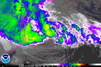
Winter Storm Brehm, also known as Snowcane Laura or Snowcane 17A, was a snowcane first spotted by the Blue Pearl Weather Prediction Center's TRMM satellite. The BPWPC and BNWC issued weather warnings on the system as Winter Storm Brehm and Snowcane 17A, respectively. The storm was called Snowcane Laura by the FMC. The storm was a Category 3 snowcane, according to the BNWC Snow Storms Scale, with maximum snowfall of 6.66 inches reported. The system tracked from the Gulf of Mexico, over Florida, and up the East Coast. The snow was made possible by a dip in the jetstream. The storm was first predicted by the GFS model at 6 days away.
Reanalysis: Minimum pressure changed from 955 to 954.

Snowcane Laura forecast track as of Aug 25, 1200Z
BLUE PEARL WEATHER PREDICTION CENTER

WINTER STORM BREHM ADVISORY 14
AUGUST 25 1200Z

THE LOW CALLED BREHM IS CURRENTLY WEST OF THE DELMARVA PENINSULA HEADING NORTH AT 45 KTS. THE LOW WILL MAKE LANDFALL ON LONG ISLAND. WIND WARNINGS ARE IN EFFECT IN LONG ISLAND AND MASSACHUSETTS. HURRICANE-FORCE WIND WARNINGS ARE IN EFFECT ALONG BREHM'S TRACK.

SNOWFALL IN THE LONG ISLAND AREA IS PREDICTED TO BE BETWEEN 6.5 AND 6.7 INCHES. THE STORM HAS ALREADY DEPOSITED SNOW BETWEEN 3 AND 5 INCHES ALONG ITS TRAJECTORY.

TRMM SATELLITE WIND READINGS ARE SHOWING WINDS OF 81 FOR BREHM. ERROR OF +-1 GIVE MAX WIND SPEED ESTIMATE OF 80.

WINTER STORM BREHM WILL DISSIPATE OVER CANADA.

OH: CENT PRES 955 MAX WIND 90
12H: CENT PRES 959 MAX WIND 89
24H: CENT PRES 971 MAX WIND 59
36H: CENT PRES 984 MAX WIND 43
48H: CENT PRES 998 MAX WIND 25
72H: DISSIPATED OVER CANADA

FORECASTER ANNA
BPWPC (BLUE PEARL WEATHER PREDICTION CENTER) WITH SAPPHIRE WEATHER MODEL ALPHA VERSION
AUG 25 1200Z
Windstorm Monique (EX18AL)[]
| Category 3 European windstorm (WEWC) | |
| | |
| Duration | August 24 – August 31 |
|---|---|
| Peak intensity | 175 mph (285 km/h) (1-min) 899 mbar (hPa) |
Windstorm Monique formed over Canada and rapidly intensified, absorbing the remnants of Winter Storm Brehm. Windstorm Monique tracked across the Atlantic and hit France at full strength. It broke the top part of the Eiffel Tower off! The storm had the lowest central pressure of any extratropical storm in its area.
Reanalysis: Windspeed estimates of 255 mph were way off. Actual windspeed was around 175 mph, as estimated by satellite imagery analysis. Initial wind speed estimates were based on damage analysis, but after investigation, it seems that the damage to the Eiffel Tower (one of the main damage points for wind estimates) was actually caused by a tornado which formed inside of the rainbands of Monique.
Snowcane Blue (EX19AL)[]
| Snowcane | |
| | |
| Duration | August 29 – September 1 |
|---|---|
| Peak intensity | 90 mph (145 km/h) (1-min) 967 mbar (hPa) |
Snowcane Blue formed over the Gulf of Mexico. It tracked over Florida and headed up the east coast, intensifying. The storm made landfall on Long Island, and then in Massachussets. The storm explosively weakened and dissipated over Maine.
Reanalysis: Nothing changed.
Hurricane Steffi (H20AL)[]
| Category 3 hurricane (NHC) | |
| | |
| Duration | August 31 – September 11 |
|---|---|
| Peak intensity | 115 mph (190 km/h) (1-min) 975.17 mbar (hPa) |
Hurricane Steffi stayed at sea for its lifetime. It was the first storm to be studied by the BPWPC's At Sea Radar/Wind Mesonet system, on account of it passing directly over the 10 test buoys, destroying 3. The storm hit the UK as an extratropical storm, called Windstorm Vivian.
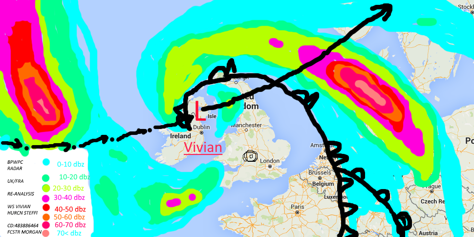
Windstorm Vivian, showing radar reflectivity, front position, and track (past and forecast)
Analysis is showing that Windstorm Vivian was a subtropical storm with hurricane-force winds, similar to Tambry.
Hurricane Steffi was actually a Category 3 hurricane, along with Bonnibel.
Reanalysis: Nothing changed.
Tropical Storm Fantala (H21AL)[]
| Tropical storm (NHC) | |
| | |
| Duration | September 10 – September 14 |
|---|---|
| Peak intensity | 45 mph (75 km/h) (1-min) 998 mbar (hPa) |
Tropical Storm Fantala formed over the Gulf of Mexico. It tracked northwest, making landfall on Florida as a tropical depression. The storm then tracked up the East Coast,intensifying to a tropical storm. It made landfall on Long Island at maximum intensity. The cyclone dissipated over Canada.
Reanalysis: Minimum pressure changed from 999 to 998
Tropical Depression 22[]
| Tropical depression (NHC) | |
| | |
| Duration | September 13 – September 18 |
|---|---|
| Peak intensity | 25 mph (40 km/h) (1-min) 1007.5 mbar (hPa) |
Depression 22 formed west of Belize, and made landfall 1 day after forming. The storm was stationary over Belize for 4 days, causing torrential rain, killing 65. The storm was poorly forecast. However, TD 22 could have been worse.
Reanalysis: Minimum pressure changes from 1008 to 1007.5.
Major Hurricane Emeraude (MH23AL)[]
| Category 5 hurricane | |
| | |
| Duration | September 13 – September 25 |
|---|---|
| Peak intensity | 190 mph (305 km/h) (1-min) 869.3 mbar (hPa) |
Major Hurricane Emeraude was a Cape Verde hurricane that hit Long Island as a Category 3 hurricane. Forecasts were pretty accurate for Emeraude, unlike for TD 22.
Hurricane Emeraude map made by hand after BPWPC HQ's power went out thanks to a tornado. It was a C3 at the time.
Post-analysis shows that Hurricane Emeraude was actually an extratropical cyclone at landfall.
Reanalysis: Nothing changed
Hurricane Ruby (H24AL)[]
| Category 5 hurricane | |
| | |
| Duration | September 16 – September 31 |
|---|---|
| Peak intensity | 260 mph (420 km/h) (1-min) 845.8 mbar (hPa) |
Hurricane Ruby formed over Cape Verde, and intensified until it absorbed Hurricane Sapphire. Then,it intensified rapidly to a Category 5 hurricane and hit Miami as a Category 5 hurricane, causing massive damage. It was tracked by BPWPC and BNWC
HRCN Ruby/Sapphire Reanalysis: After close study of dropsonde wind data, satellite imagery, aircraft radar data, and scatterometer wind observations, it was found that the cyclonic circulation of Ruby absorbed that of Sapphire, not the other way around as noted in official advisories.
Major Hurricane Sapphire (MH25AL)[]
| Category 3 hurricane | |
| | |
| Duration | September 17 – September 20 |
|---|---|
| Peak intensity | 120 mph (195 km/h) (1-min) 956 mbar (hPa) |
Hurricane Sapphire formed from a tropical disturbance over Cape Verde. It was absorbed by MH Ruby
HRCN Ruby/Sapphire Reanalysis: After close study of dropsonde wind data, satellite imagery, aircraft radar data, and scatterometer wind observations, it was found that the cyclonic circulation of Ruby absorbed that of Sapphire, not the other way around as noted in official advisories.
Superstorm Faith (SP26AL)[]
| Superstorm | |
| | |
| Duration | September 25 – October 28 |
|---|---|
| Peak intensity | 3910 mph (6290 km/h) (1-min) 42.94 mbar (hPa) |
Superstorm Faith formed when a tropical wave passed over a pocket of 60-degrees-Celsius water. The system intensified rapidly, causing winds over the speed of sound. Sonic booms were a hindrance to intensification, but the cyclone reached a central pressure of 42.98 hPa. The cyclone weakened and hit the Lesser Antilles as a Category 7 hurricane. The storm was tracked by all agencies.
Reanalysis: Minimum pressure changes from 42.98 to 42.94 due to new analysis of buoy data.
Tropical Depression 27/Tropical Storm Aelita (TS27AL)[]
| Tropical depression | |
| | |
| Duration | September 26 – October 2 |
|---|---|
| Peak intensity | 35 mph (60 km/h) (1-min) 998.4 mbar (hPa) |
This system was tracked as a tropical storm, but was found to actually have been a tropical depression. The storm was kept weak by high upper-level winds coming off SP26AL (Faith) as it reached maximum intensity. TD Aelita made landfall in Belize.
Reanalysis: Minimum pressure changed from 999.4 to 998.4.
Tropical Storm Elysium (TS28AL)[]
| Tropical storm | |
| | |
| Duration | October 2 – October 8 |
|---|---|
| Peak intensity | 40 mph (65 km/h) (1-min) 983.87 mbar (hPa) |
After TD 27's dissipation, a pool of moisture over the Yucatan Peninsula became Tropical Depression 28 over land. The storm moved over the Gulf of Mexico and intensified into TS Elysium. The storm hit Louisiana and dissipated over land.
Reanalysis: Minimum pressure changes from 984.44 to 983.87.
Hurricane Medli (H29AL)[]
| Category 1 hurricane | |
| | |
| Duration | October 12 – October 22 |
|---|---|
| Peak intensity | 80 mph (130 km/h) (1-min) 984.98 mbar (hPa) |
Medli was a storm that stayed at sea for it's entire life. On October 12, a weak tropical low merged with a TD and created Medli, a tropical storm that was pretty strong. At that point (October 14), it was at 70 mph winds. After going over above-average ocean temps, it developed into a hurricane on October 18. It then slowly (in 4 days) dissipated.
Reanalysis: nothing changed.
Major Hurricane Lana[]
| Category 5 hurricane | |
| | |
| Duration | October 28 – November 11 |
|---|---|
| Peak intensity | 230 mph (370 km/h) (1-min) 902 mbar (hPa) |
MH Lana formed from a disturbance left by Faith as it dissipated. Lana intensified to a Category 5 hurricane north of the Azores, breaking Hurricane Injima's record. The storm went on to hit Spain and France as a Category 3 hurricane.
Reanalysis: Nothing changed
Subtropical Cyclone Rose[]
| Subtropical cyclone | |
| | |
| Duration | November 3 – November 12 |
|---|---|
| Peak intensity | 100 mph (165 km/h) (1-min) 941 mbar (hPa) |
Cyclone Rose formed from an extratropical cyclone headed up the East Coast. The cyclone turned left and hit New Jersey at maximum intensity.
Reanalysis: Nothing changed.
Cyclone Rose approaching landfall
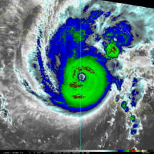
Hurricane Skyler[]
| Category 4 hurricane | |
| | |
| Duration | November 9 – November 19 |
|---|---|
| Peak intensity | 140 mph (220 km/h) (1-min) 951 mbar (hPa) |
Hurricane Skyler formed from a tropical wave east of Cape Verde. The cyclone reached peak intensity south of Cuba. It tracked into the Gulf of Mexico, where it interacted and merged with an intense extratropical cyclone.
Reanalysis: Nothing changed.

At peak intensity
Subtropical Storm Leia[]
| Subtropical storm | |
| | |
| Duration | November 17 – November 30 |
|---|---|
| Peak intensity | 70 mph (115 km/h) (1-min) 978 mbar (hPa) |
The extratropical storm that absorbed Skyler tracked over Florida on November 20, and went northwest up the East Coast. The cyclone became subtropical west of the Delmarva Peninsula. The storm continued and hit Nova Scotia and Newfoundland at maximum intensity on November 24, losing tropical characteristics next day. The cyclone then went on to make landfall in France as an extratropical storm. The cyclone was absorbed by another windstorm at around 12:00 on November 30.
Reanalysis: Nothing changed.
Major Hurricane Seriffe[]
| Category 5 hurricane | |
| | |
| Duration | November 19 – November 26 |
|---|---|
| Peak intensity | 195 mph (315 km/h) (1-min) 923 mbar (hPa) |
Hurricane Seriffe formed from a pair of invests merging into a tropical depression. The cyclone intensified into Tropical Storm Seriffe on November 21. The cyclone was a Category 5 by the 24th. The cyclone hit Belize at maximum intensity, and crossed into the Pacific basin as a Category 1 hurricane on the 26th. It was named Hurricane Calico, and it did not affect land in the Pacific.
Reanalysis: Minimum pressure changed to 923 from 921
Megacane Tetra[]
| Megacane | |
| | |
| Duration | November 27 – December 25 |
|---|---|
| Peak intensity | 17515 mph (28180 km/h) (1-min) 25.1 mbar (hPa) |
Megacane Tetra formed from Tropical Depression 35A. The cyclone passed over water warmed up to 75 degrees Celsius by a massive volcanic eruption on the Mid-Atlantic Ridge. The cyclone rapidly intensified into a massive megacane. The cyclone's wind speeds were multiple times over the speed of sound, causing sonic boom weakening, similar to in Faith. The cyclone intensified even more than Faith, before sound-wave weakening started to affect the hurricane. The storm weakened to a Category 10 on December 10. Luckily, when megacanes are at full intensity, their winds flatten the ocean under them. However, as a Cat-10, it caused 80-foot waves that swamped the desolate Bermuda, already destroyed by Landon. 30-foot swells covered the entire Atlantic Ocean. The cyclone reintensified to a hypercane over the Caribbean Sea, and hit Belize at maximum intensity as a hypercane that caused tsunami-like damage all over the Caribbean Sea and Gulf of Mexico. Untold devastation happened, because literally noone knows. All of coastal Belize was flooded, and all predictions say at least 3 months will pass until it is dry again. Tetra crossed into the Pacific as a Category 4 hurricane (Hurricane Zelda) on the 25th, where it continued on to do pretty much nothing in the Pacific.
Post- Storm Analysis: Tetra was found to have been the strongest storm of the season in terms of wind speeds, Kylie was the strongest in terms of pressure.
Reanalysis: After Belize dried, search teams from BPWPC found observation records that indicated winds of around 17515 mph, changed from a satellite-estimated 17280; and a pressure of 501 mb was recorded within the middle rings of the cyclone, changing minimum pressure from 20 to 25.
Update: After extensive searches of the affected parts of Belize, BPWPC has finalized the death count at 252,747, and the damages as definitely over $240,000,000. Also, the cyclone actually entered the Pacific as a Category 3 hurricane. More weather data was recovered that appears to support our conclusion that maximum wind speed was 17515.3 mph, and central pressure was 25.1 mb.
Tropical Storm Anthea[]
| Tropical storm | |
| | |
| Duration | December 4 – December 15 |
|---|---|
| Peak intensity | 45 mph (70 km/h) (1-min) 1000 mbar (hPa) |
TS Anthea's precursor, TD 36A, was unable to intensify to a tropical storm until December 11, because of upper-level winds caused by Tetra. TS Anthea hit Bermuda at full intensity, leading many to speculate what Bermuda did to nature to get it so mad.
Reanalysis: Minimum central pressure changed from 1001 to 1000.
Tropical Depression 37A[]
| Tropical depression | |
| | |
| Duration | December 25 – December 30 |
|---|---|
| Peak intensity | 25 mph (35 km/h) (1-min) 1005.5 mbar (hPa) |
Also known as the "Really? cyclone", this storm formed west of Cape Hatteras and sped over the former location of Bermuda before dissipating.
Reanalysis: Minimum pressure changes from 1007 to 1005.5.
Major Hurricane Aryll[]
| Category 5 hurricane | |
| | |
| Duration | December 25 – January 12 |
|---|---|
| Peak intensity | 255 mph (405 km/h) (1-min) 862 mbar (hPa) |
Major Hurricane Aryll formed out of a mesoscale convective vortex (MCV) over the Gulf of Mexico. Slowly moving,it intensified to a Category 5 on December 31, becoming the latest Category 5 hurricane ever. It started to weaken on January 3, and started to track south. It hit Cuba as a tropical storm, and became a remnant low. This low dissipated on January 12.
Reanalysis: Aryll hit Cuba as a weak Cat 1, instead of a strong TS, as previously thought. Minimum pressure is also changed from 858 to 862.
Hurricane Susete[]
| Category 4 hurricane (SSHWS) | |
| | |
| Duration | December 3 – December 29 |
|---|---|
| Peak intensity | 145 mph (230 km/h) (1-min) 945 mbar (hPa) |
Hurricane Susete first started off as a tropical wave from Puerto Rico. After, it in 15 hours went from a depression to a (Cat. 2) hurricane, breaking some records and a offseason record. After that, it went slowly over the Bahamas, and in 15 seconds, it traveled 2 km and slowed down as a Cat 4 hurricane. It then quickly dissipated in 19.384834 hours.
TD 41L[]
| Tropical depression (SSHWS) | |
| | |
| Duration | December 5 – December 7 |
|---|---|
| Peak intensity | 55 km/h (35 mph) (1-min) 1001 hPa (mbar) |
TD 41L formed from a pool of moisture and a tropical wave merging together. It then shortly dissipated under the Bahamas on December 7.
Subtropical Storm Toriel[]
| Subtropical storm | |
| | |
| Duration | December 30 – January 7 |
|---|---|
| Peak intensity | 45 mph (75 km/h) (1-min) 999 mbar (hPa) |
Tropical Storm Toriel formed from a disturbance in the Gulf of Mexico. The cyclone quickly reached maximum intensity, and then weakened to a remnant low. The storm hit Florida with winds of around 20 knots, and dissipated east of Delaware.
Reanalysis: Toriel was actually a subtropical storm.
Winter Storm Flora[]
| Snowcane | |
| | |
| Duration | August 28 – September 18 |
|---|---|
| Peak intensity | 145 mph (235 km/h) (1-min) 955 mbar (hPa) |
Megacane Nicole[]
| Megacane | |
| | |
| Duration | December 25 – Active |
|---|---|
| Peak intensity | 19415 mph (31245 km/h) (1-min) -89 mbar (hPa) |
This late December megacane formed from a tropical wave interacting with a trough. Tropical Depression 44A was formed from that and quickly strengthened into Tropical Storm Nicole. Nicole rapidly deepened into a megacane on December 27. As it ravaged through Cuba, it killed nearly 28,000 people and left 40,000 missing. The so called "Christmas storm" was one of the deadlier storms of the 82590 Atlantic hurricane season. Also the wave would have been formed by a butterfly flapping its wings but it got eaten.
Infinite Storm Owen[]
| Infinite Storm | |
| | |
| Duration | August 28 – September 10 |
|---|---|
| Peak intensity | 41360 mph (66545 km/h) (1-min) -2980 mbar (hPa) |
Owen formed from a huge extratropical cyclone that had winds of 2450 mph at its peak. Owen quickly developed and explosively intensified into a infinite storm. The huge storm completely flooded the East Coast of the US (or what was left of it, not much was left due to Landon) before making landfall on what was New York City. Owen transitioned into a extratropical cyclone with winds of 14560 mph over Buffalo, NY. Owen continued moving over Canada before looping and heading back south. Owen entered the Gulf of Mexico on September 8. Although it intensified into a hypercane with winds of 565 mph, the storm was absorbed by Infinite Storm Yuri. It could not be retired. (see reason below). Also Owen enlarged the Gulf of Mexico somewhat.
Post-Analysis: Owen made landfall on New York City, not Long Island, as the initial report said. Also Owen had a pressure of -2980 instead of the initial -2765.
Retired Storm Names[]
After the season, the names Francella, Gregory, Hyce, Injima, Kylie, Bonnibel, Monique, Emeraude, Ruby, Faith, Lana, Seriffe, Tetra, Susete, & Nicole were retired due to their intensity, damage and death counts. Also Owen could not be retired because when the NHC retired it people protested.
|INCREDIBLYPOWERFULINSANELYDEADLYLOWPRESSUREHIGHPR|ESSUREHIGHWINDS-|DARKGALAXYLIKEHYPOTHETICALTHINGRECYCLEDABLE-|WORSTEST-WORSTER-WORST-WORSE-TERRIBLYHORRIBLYBAD-|REALBLACKHOLE-ULTIMATE-HYPERHYPER-MEGA-|SUPERHYPER-SUPERDUPER-HYPER-SUPER MINI BLACK HOLE |Adolphblainecharlesdavidearlfrederickgeraldhubert|irvinjohnkennethlloydmartinnerooliverpaulquincyra|ndolphseniorshermanthomasuncasvictorwolfeschlegel|steinhausenbergerdorffxerxesyancyzeus[]
| Hyper Mini Black Hole | |
 | |
| Duration | June 3 – Can't Dissipate |
|---|---|
| Peak intensity | 1.278761001151E+85 mph (2.057572001852E+85 km/h) (1-min) -100000000010011110000000-0111000101111100000011100000111100001-1111000111111001111111011111111000001-0100011110000011111100001111 mbar (hPa) |
This storm was the strongest since Ivan & Quinn.
He is their cousin.
He became a galaxy next 3 years and swallowed the Laniakea Supercluster.
Thee eenD.