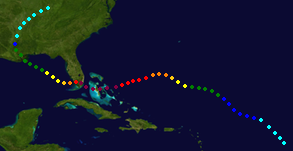
Hurricane Bonnie Track.
This is my prediction for the Atlantic Hurricane Season. It has 15 Named Storms.
Tropical Systems[]
Tropical Storm Alex Track
Alex near North Carolina Pre-Landfall.
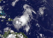
Tropical Storm Alex (June 12-19) Peak Winds: 50MPH (Gusts 65MPH)
On June 9, The National Hurricane Center Began Monitoring a tropical low pressure system about 300 Miles NE on the Bahamas. It quickly became Tropical Depression One-E. It continued to move forward, becoming Tropical Storm Alex Just before landfall near Cape Hatteras, North Carolina, a mid strength tropical storm. I caused Minimal damage to North Carolina. The System moved Northeast, now a tropical depression, before becoming a remnant low, ravaging New England with several inches of rain and Flash Flooding.

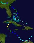
Hurricane Bonnie Track.

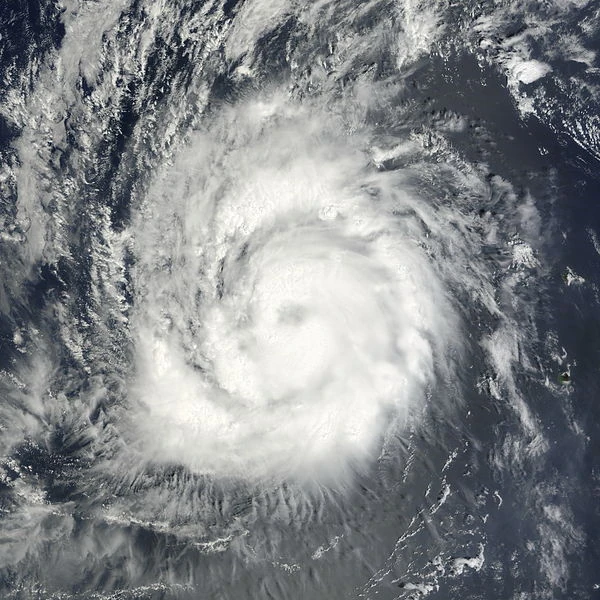
Hurricane Bonnie Shortly before Landfall in Cuba.
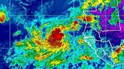
Hurricane Bonnie- Cat1 (June 27- July 8) Peak Winds: 75MPH (Gusts 90MPH)
On June 23, the NHC began monitoring a low pressure area located 275 Miles due north of Caracas, Venezuela. The system was originally not expected to develop due to it's location near land, but the low moved northwest and became Tropical Depression 2-E on June 27. The system began the show a well defined center and became named Tropical Storm Bonnie on June 29. Bonnie Strengthened to a category 1 Hurricane while moving slowly north towards Cuba. Bonnie made Landfall near Havana, Cuba- a weak cat1. Bonnie caused 10 Deaths and substantial damage to the capital Havana.
Bonnie, Now a tropical Depression, hits the Bahamas and causes minimal damage. The system fluctuates between a tropical storm and tropical depression before making a 2nd landfall near Savannah, Georgia, a minimal tropical storm, causing minimal damage to Georgia.

Track of 3-E
Tropical Depression 3-E (July 4-7) Peak Winds: 30MPH (Gusts 45MPH)
On June 29, The NHC began monitoring a system located about 1000 Miles West-Southwest of the Cape Verde islands. The system slowly developed and became tropical depression Three-E. The system failed to develop farther, and became a remnant low on July 7.

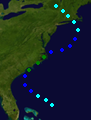
Track of Hurricane Colin.

Hurricane Colin Approaching New Jersey.
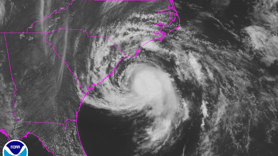
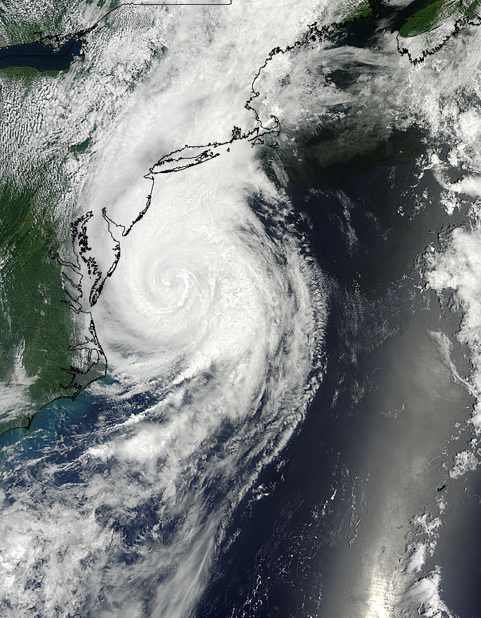
Hurricane Colin- Cat2 (July 6- 19) Peak Winds: 100 MPH (Gusts 120MPH)
On July 2, The NHC Began monitoring a system located about 550 Miles South-Southwest of Bermuda. The System quickly developed and became tropical depression 4-E. The system farther developed and became Tropical Storm Colin on July 9. Colin then moved along the eastern seaboard, strengthening into a Category 1 Hurricane and eventually a weak Category 2 before landing near Cape May, NJ, with winds of 100MPH. The storm caused serious damage and 13 Deaths in New Jersey, Pennsylvania, and Delaware. The remnants brought New England several inches of rain and flash flooding.

Hurricane Danielle Track.

Hurricane Danielle before landfall.
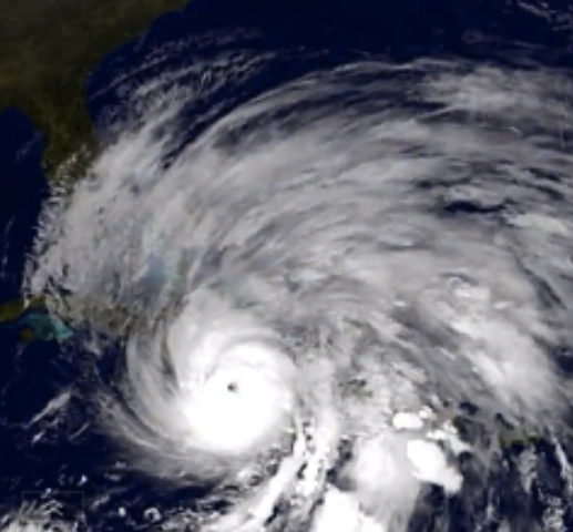
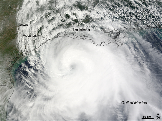
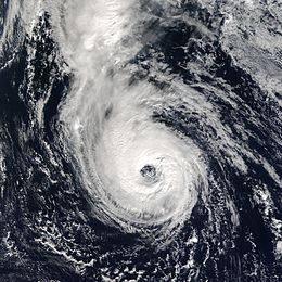
Hurricane Danielle- Cat5 (July 16- 30) Peak Winds: 155MPH (Gusts 170MPH)
On July 13, the NHC began monitoring a area of thunderstorms located about 100 Miles Northeast of Honduras. It Quickly developed into Tropical Depression 5-E while moving Northwest. Winds began to pick up and it was named Tropical Storm Danielle the next day. As Danielle moved into the Gulf of Mexico, where there was little wind shear, Danielle Quickly became a Cat1 and later a Cat2. Danielle then began a period of stationary movement, and strengthened to a Strong Cat4 over the water, before moving towards Texas. Hurricane Danielle made landfall near Galveston, Texas, a weak category 5, with wind gusts to 170MPH. Danielle killed 105 in Texas and Louisiana, with devastating Damage. The Remnants of Danielle brought the Central Plains some much needed rainfall.


Track of Hurricane Earl.

Hurricane Earl near landfall in Puerto Rico.
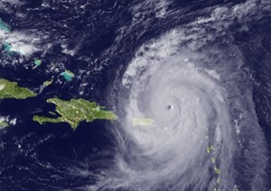
Hurricane Earl- Cat1 (August 13- 20) Peak Winds: 80MPH (Gusts 100MPH)
On July 27, the NHC Began Monitoring a disorganized Low Pressure area located about 250 Miles west of Cape Verde. The area slowly developed, and Became Tropical Depression 6-E while moving west. It slowly increased in Intensity and eventually became Tropical Storm Earl. On August 17, Earl Developed a Eye and became Hurricane Earl. Now near the lesser Antilles, Earl made landfall, causing 15 Deaths. Earl Remained a Category 1, Curving North Towards Puerto Rico. Strong Wind shear began to tear Earl apart, but made landfall in Puerto Rico a 75MPH Cat1 Storm, causing 7 Deaths. Tropical Depression Earl hit Eastern Hispaniola before dissipating over the Eastern Bahamas.

Track of 7-E.
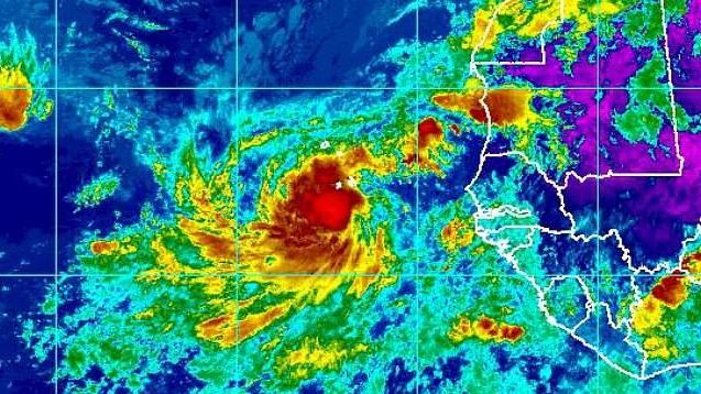
Tropical Depression 7-E Near Cape Verde.
Tropical Depression 7-E (August 15-18) Peak Winds: 30MPH (Gusts 40MPH)
On August 10, the NHC Began monitoring a system located just west of Liberia. It slowly developed into Tropical Depression 7-E. The system moved north to impact the Cape Verde Islands, causing little damage. The system then quickly dissipated, and was absorbed into Tropical Storm Fiona.

Hurricane Fiona track.


Tropical Storm Fiona near the Azores.
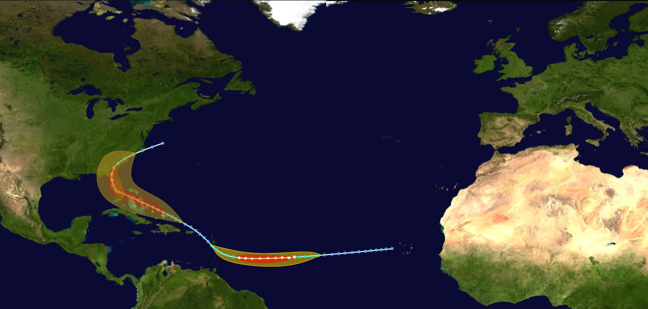
Hurricane Fiona- Cat1 (August 20- September 5) Peak Winds: 85MPH (Gusts 105 MPH)
On August 12, the NHC began monitoring a 2nd low pressure area located about 400 Miles SW of the Canary Islands. Despite the unusual location, it developed and became Tropical depression 8-E on August 20. The system absorbed the remnants of 7-E and as a result, became Tropical Storm Fiona. Fiona became a Cat 1 in the East Central Atlantic. However, Wind Shear began to increase as Fiona neared the Azores, making landfall as a weak Tropical Storm, causing minimal damage. Fiona's remnants then quickly dissipated.

Hurricane Gaston Track.


Image of Gaston.
Hurricane Gaston- Cat5 (August 23- September 16) Peak Winds: 170MPH (Gusts 200MPH)
On August 16, The NHC began monitoring a area of showers and thunderstorms located about 700 Miles East of the Lesser Antilles. It moved northwest and became tropical depression 8-E. Moving West, Gaston was in a favorable environment, and quickly became a Hurricane on August 29. As Gaston turned towards the Bahamas, it entered a highly conductive environment, and strengthened to a category 5 storm. Gaston Caused Massive Damage to the Bahamas, with 177 Killed. Gaston also hit South Florida just days later, also a Cat 5, causing devastating Damage to Florida. Gaston then weakened in the Northeastern Gulf before making a 3rd landfall near New Orleans, Louisiana, a weak Tropical Storm.


Hurricane Hermine Track.

Hurricane Hermine, just west of Europe.
Hurricane Hermine- Cat3 (August 24- September 11) Peak Winds: 120MPH (Gusts 140MPH)
On August 15, The NHC began monitoring a tropical wave over Burkina Faso. The wave became a tropical depression the moment it left the coast of Africa, becoming tropical depression 9-E. Hermine quickly turned north, and with the waters between the Cape Verde Islands and Africa being favorable for development, 9-E quickly became Tropical Storm Hermine on August 26. Hermine quickly developed a eye and became a cat1 hurricane just 24 hours later. The rip currents from Hermine killed 10 in both Africa and the Cape Verde Islands, but the two landmasses were mostly unaffected. Hermine continued to move north. It hit Spain's Canary Islands as a weak Cat3 Hurricane, causing 29 Deaths and 4 Billion in Damage. Hermine began to Move NNE, but wind shear began to tear Hermine apart. Hurricane Hermine made landfall near Huelva, Spain- a weak Cat1. Hermine caused 5 deaths and 350 Million USD Damage to Spain. The Remnants continued to bring the Iberian peninsula heavy rain and gusty winds, before the remnants moved out to sea and dissipated.

Track of tropical Storm Ian.

Tropical Storm Ian goes between Hispaniola and Puerto Rico without incident.
Tropical Storm Ian- Tropical Storm (September 2-10) Peak Winds: 55MPH (Gusts 70MPH)
On August 27, The NHC began monitoring a low pressure area located roughly 300 Miles east of the lesser Antilles. It became Tropical Depression 10-E. It moved south of Puerto Rico and became tropical storm Ian between Hispaniola and Puerto Rico, causing high tide but no damage. Ian then moved north, and dissipated while south of Bermuda.

Track of Tropical Depression 11-E.
Subtropical Depression 11-E (September 3-6) Peak Winds: 35MPH (Gusts 50MPH)
On August 24, The NHC began monitoring a low pressure area located nearly 500 Miles south of Bermuda. It became a depression, however was ruled Subtropical. As it moved north, it began to strengthen but came just short of Subtropical Storm Status before dissipating.


Track of Hurricane Julia.

Hurricane Julia while east of Florida.
Hurricane Julia- Cat2 (September 13-24) Peak Winds: 95MPH (Gusts 110MPH) On September 2, The NHC began monitoring a tropical wave Located about 750 Miles East Southeast of the lesser Antilles. Moving west into a favorable environment, it quickly developed into Tropical Depression 12-E and eventually Julia one day later. Julia continued to strengthen, and made landfall on Barbados as a strong Tropical Storm, causing substantial damage to the island and 25 deaths. Julia continued to move west and became a Cat2 Hurricane Just before landfall on Hispaniola, causing 56 Deaths and 2 Billion USD in damage. Julia Crossed through the Bahamas as a Tropical Storm, causing minimal impacts. As Julia entered a area of favorable development just east of Florida, it became a category 1. Julia mad landfall near Dover, Delaware as a Weak Cat 1, Causing Minimal damage. Julia crossed the Chesapeake and made a second landfall near Baltimore, Maryland as a tropical storm, causing minimal damage. The remnants brought flash flooding and several inches of rain to the North Eastern United States.