Watch the track animation, made by Jnlt215 (thank you!) for Alu here: https://www.youtube.com/watch?v=h9tMooH9o3A
| Category 5 severe tropical cyclone (Aus scale) | |
|---|---|
| Category 5 tropical cyclone (SSHWS) | |
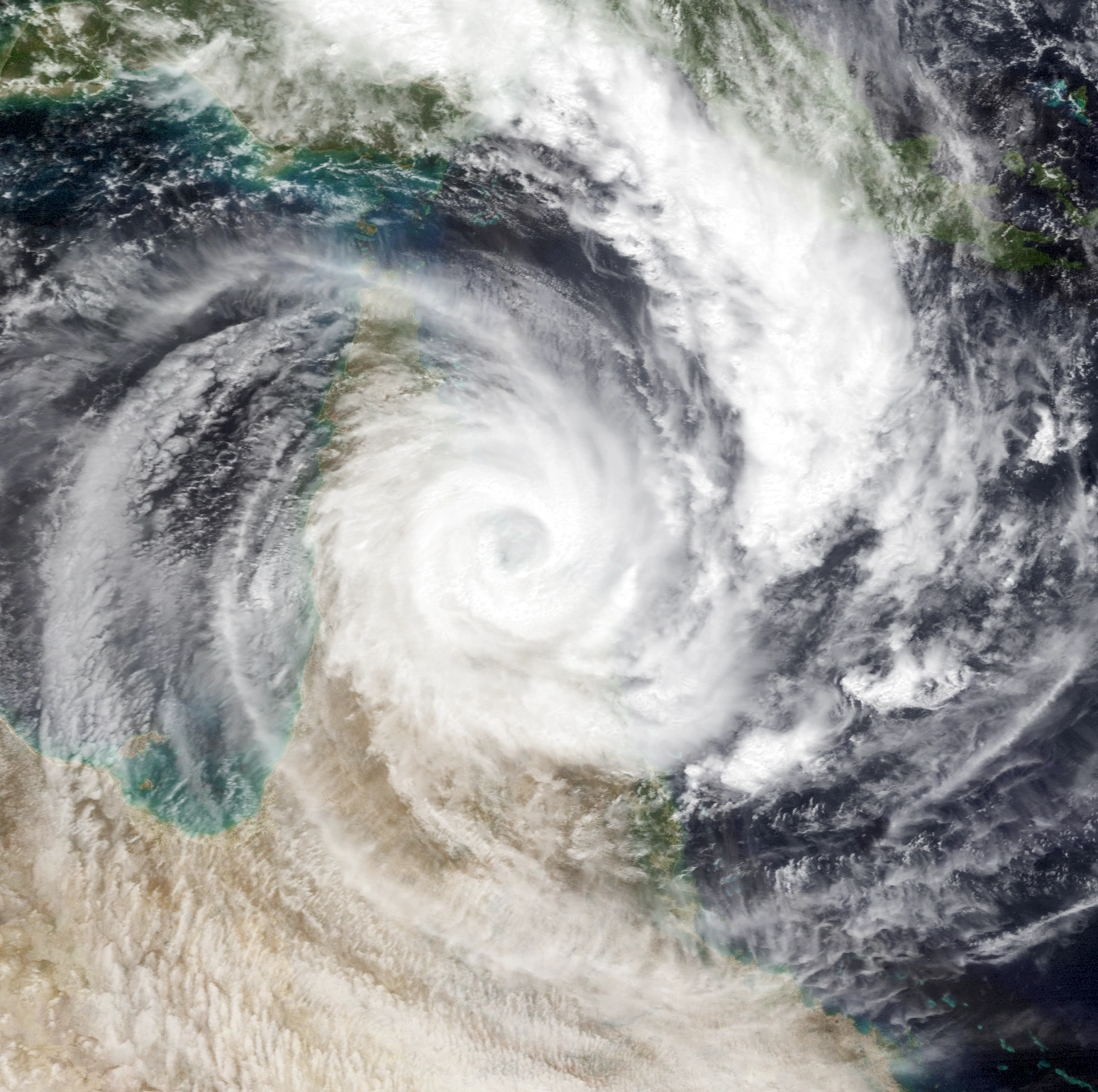
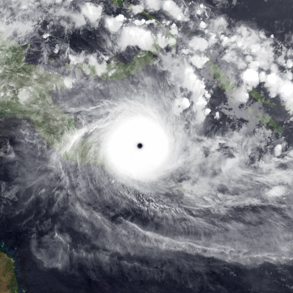 Cyclone Alu shortly after peak intensity on January 15, 2024 | |
| Formed | January 13, 2024 |
| Dissipated | January 24, 2024 |
| Highest winds | 10-minute sustained: 260 km/h (160 mph) 1-minute sustained: 305 km/h (190 mph) |
| Lowest pressure | 892 hPa (mbar); 26.34 inHg |
| Fatalities | 4,241 total, 542 missing |
| Damage | $382.2 million (2024 USD) |
| Areas affected | Papua New Guinea (Bougainville Island, New Britain, New Ireland, Papuan Peninsula, D'Entrecasteaux Islands), Australia (Queensland, Northern Territory), Solomon Islands |
| Part of the 2023-24 Australian region cyclone season | |
Cyclone Alu (also known as Severe Tropical Cyclone Alu) was the most intense Australian tropical cyclone on record, with a minimum barometric pressure of 892 mbar (26.34 inHg) and 10-minute sustained winds of 160 mph (260 km/h). It caused catastrophic damage in southeastern Papua New Guinea after making landfall there as a strong Category 4 cyclone on the Australian scale. The precursor to Alu was a tropical low that formed near the island of New Ireland on January 12. At 12:00 UTC on January 13, the low developed into a tropical depression. Six hours later, it strengthened into a tropical storm. Shortly after becoming a tropical storm, Alu underwent explosive intensification. In a 30-hour period, Alu's barometric pressure dropped from 994 mbar (29.35 inHg) to 892 mbar (26.34 inHg), and its 10-minute sustained winds increased from 60 mph (95 km/h) to 160 mph (260 km/h). At its peak on the afternoon of January 15, the Joint Typhoon Warning Center (JTWC) reported that Alu was an extremely powerful Category 5-equivalent cyclone on the Saffir-Simpson hurricane scale with 1-minute sustained winds of around 190 mph (305 km/h).
Due to land interaction and an eyewall replacement cycle, Alu began to weaken quickly. At 18:00 UTC on January 16, it made landfall near Alotau, Papua New Guinea as a strong Category 4 cyclone on the Australian scale. After emerging into the Coral Sea, Alu continued to weaken. By midday on January 18, Alu had weakened to a Category 1 tropical cyclone. Later that day, Alu began to restrengthen. Early on January 21, Alu reached its secondary peak intensity as a Category 3 tropical cyclone with 10-minute sustained winds of 80 mph (130 km/h) and a minimum barometric pressure of 973 mbar (28.73 inHg). Three hours later, Alu made landfall near Yarraden, Queensland. Alu briefly entered the Gulf of Carpentaria on January 22 before making another landfall near Burketown, Queensland early on January 23. At around 06:00 UTC on January 24, Alu degenerated into a remnant low while located about 225 miles (362 kilometers) northeast of Alice Springs.
Because of Alu's extremely rapid and unprecedented rate of intensification, residents of southeastern Papua New Guinea were given little time to prepare or evacuate. This lack of preparation led to extensive damage and loss of life. New Britain and New Ireland were heavily affected by Alu; 20 people were killed on the former island, while 87 people were killed and 7 people were reported missing on the latter island. Widespread flooding occurred as a result of a storm surge that reached 25 ft (7.6 m) in some places. In mainland Milne Bay Province alone, 2,233 people died. 90% of the buildings in the town of Alotau, which suffered a direct impact from Alu, were damaged or destroyed. In the D'Entrecasteaux Islands, which Alu passed through as a weakening Category 5-equivalent cyclone on the Saffir-Simpson hurricane scale, 750 people died. In the Trobriand Islands and Marshall Bennett Islands, 1,046 people were killed and 21 were reported missing. On Woodlark Island, 33 people were killed. Normanby Island, Fergusson Island, and Goodenough Island were declared uninhabitable for nine months after the storm. Volunteers reported that nearly every building in the town of Esa'Ala was destroyed by Alu. 10 people were killed in Port Moresby because of flooding caused by Alu's outer rainbands. Local flooding in Oro Province led to 26 fatalities, while extensive flooding in Central Province led to 33 fatalities. Many settlements in these provinces experienced severe property damage as well. In Australia, the effects of Alu were not nearly as severe. This can be attributed to both the storm not being able to fully restrengthen after interacting with Papua New Guinea and Australia's effective tropical cyclone warning system. A 12 ft (3.7 m) storm surge caused significant beach erosion and coastal flooding. 3 people were killed in Queensland when their house collapsed. Alu's remnants produced heavy rainfall in the Northern Territory. Overall, as a result of Alu, 4,241 people were killed and 542 people were reported missing; as well as this, Alu caused US$382.2 million in damage.
Meteorological history[]

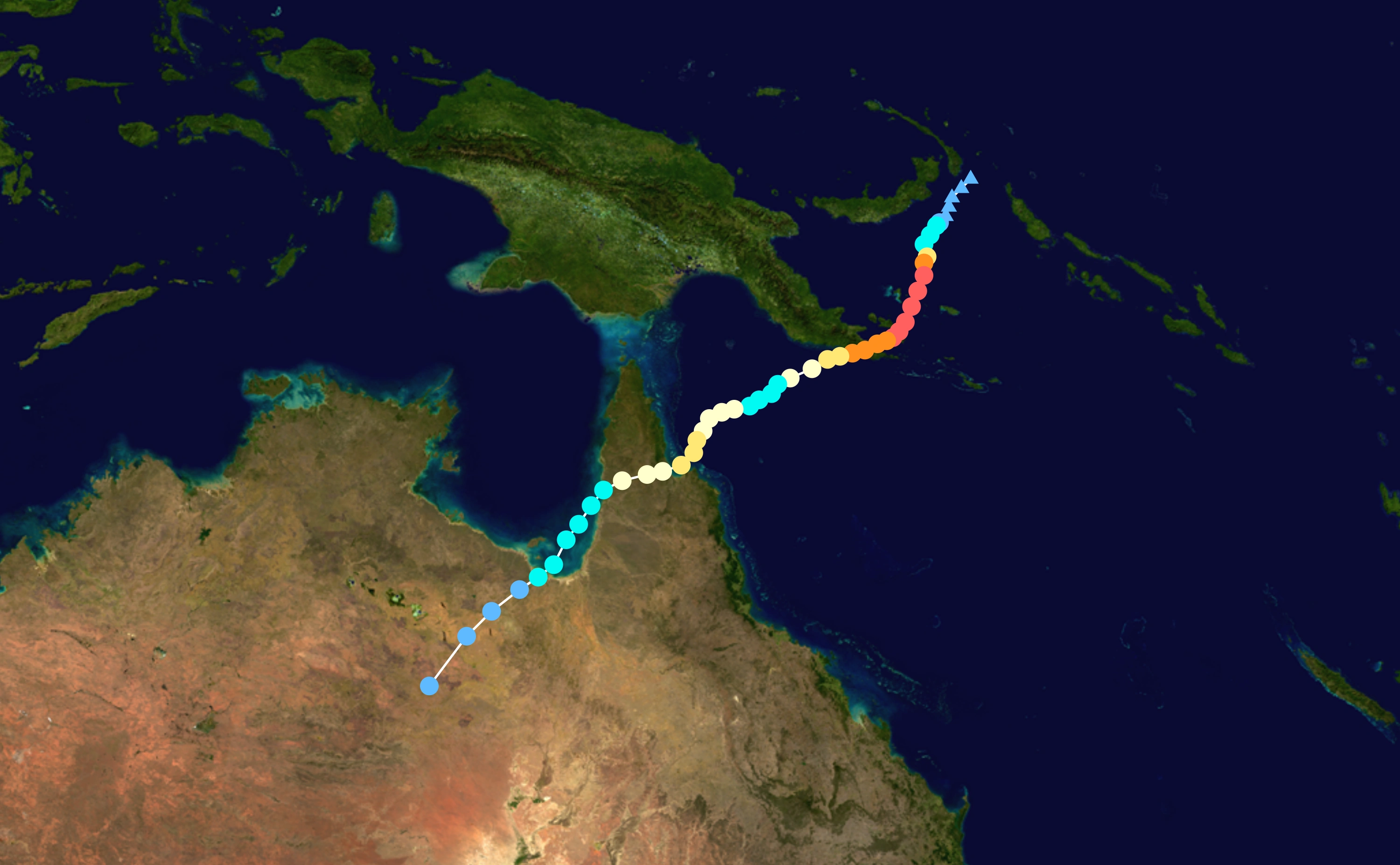
Map plotting the storm's track and intensity, according to the Saffir–Simpson scale
Tropical storm (39–54 mph, 63–87 km/h)
Category 1 (74–95 mph, 119–153 km/h)
Category 2 (96–110 mph, 154–177 km/h)
Category 3 (111–129 mph, 178–208 km/h)
Category 4 (130–156 mph, 209–251 km/h)
Category 5 (≥157 mph, ≥252 km/h)

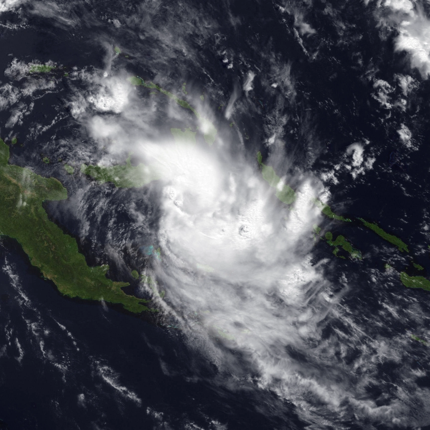
Alu shortly after strengthening into a tropical storm
On January 12, a tropical low formed near the Papua New Guinean island of New Ireland. As a result of being located within an area of extremely low wind shear and sea surface temperatures of around 90 °F (32 °C), the system began to intensify quickly. Early on January 13, a large burst of convection prompted the Joint Typhoon Warning Center (JTWC) to issue a Tropical Cyclone Formation Alert for the disturbance. At 10:00 UTC that day, the JTWC classified the system as Tropical Cyclone 05P. Two hours later, TCWC Port Moresby initiated advisories on the system, naming it Alu. For the next day, Alu slowly traveled southwards as it continued to strengthen. From January 14 to January 15, Alu underwent explosive intensification. In approximately 30 hours, Alu's minimum barometric pressure dropped from 994 mbar (29.35 inHg) to 892 mbar (26.34 inHg) and its 10-minute sustained winds increased from 60 mph (95 km/h) to 160 mph (260 km/h). During this period, Alu developed excellent poleward and equatorward outflow and cloud tops of around -140 °F (-96 °C) that wrapped around an eye 21.2 miles (34 kilometers) in diameter. On the afternoon of January 15, Alu reached its peak intensity with a minimum barometric pressure of 892 mbar (26.34 inHg). At 12:00 UTC that day, the Australian Bureau of Meteorology reported that Alu was a Category 5 cyclone on the Australian scale with 10-minute sustained winds of 160 mph (260 km/h). The Joint Typhoon Warning Center, however, reported that Alu was a Category 5-equivalent cyclone on the Saffir-Simpson scale with 1-minute sustained winds of 190 mph (305 km/h). These measurements made Alu the strongest Australian region tropical cyclone on record in terms of barometric pressure, 10-minute sustained winds, and 1-minute sustained winds.


.png)
Cyclone Alu making landfall in Papua New Guinea late on January 16
Shortly after achieving peak intensity, Alu began to steadily weaken as a result of upwelling, interaction with the mountainous terrain of southeastern Papua New Guinea, and an ongoing eyewall replacement cycle. The storm also turned westward in response to a low pressure system to its northwest. By 16:00 UTC on January 16, Alu had weakened to a Category 4 cyclone on the Australian scale. Later that day, Alu made landfall near Alotau, Papua New Guinea with 10-minute sustained winds of 125 mph (200 km/h) and a minimum barometric pressure of 923 mbar (27.26 inHg). Early the next day, Alu emerged into the Coral Sea as a weak Category 4 cyclone and started to weaken more rapidly due to increasing vertical wind shear. By midday on January 17, Alu's eye had completely dissipated. Over the next day, Alu became more disorganized and lost much of its deep convection.
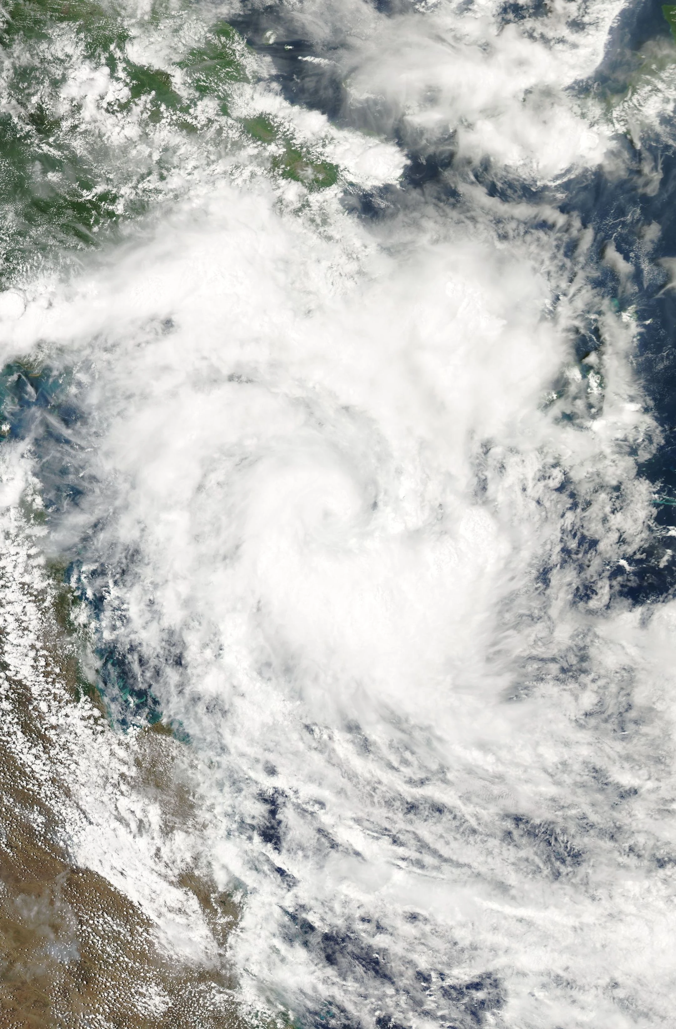
On January 18, Alu began to restrengthen as conditions around the system became more favorable. At 18:00 UTC on January 19, Alu strengthened into a Category 3 cyclone on the Australian scale. Because of a high-pressure system located to its southeast, Alu turned southward. The presence of a ragged eye on satellite imagery prompted the Joint Typhoon Warning Center to upgrade Alu to a Category 2-equivalent cyclone on the Saffir-Simpson scale at 12:00 UTC on January 20. Early on January 21, Alu reached its secondary peak intensity as a low-end Category 3 cyclone on the Australian scale with 10-minute sustained winds of 80 mph (130 km/h) and a minimum barometric pressure of 973 mbar (28.73 inHg). Three hours later, Alu made landfall near Yarraden, Queensland. After making landfall, Alu weakened considerably. By 18:00 UTC on January 21, thunderstorm activity near the center of the storm had decreased significantly.

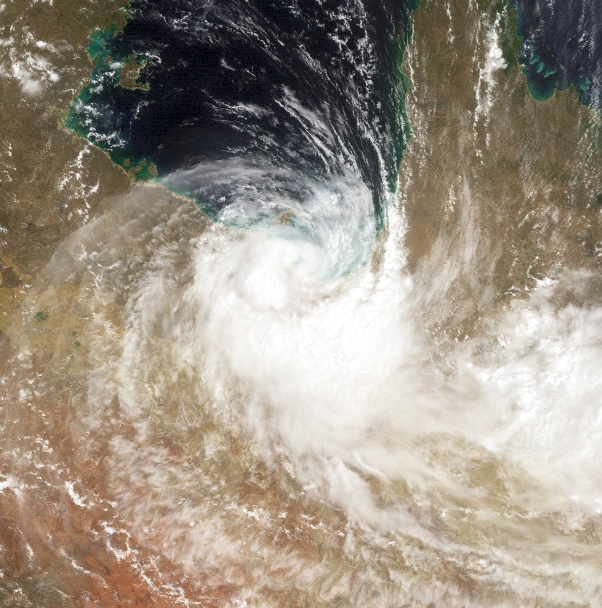
Cyclone Alu making its final landfall in Queensland on January 23
Early on January 22, Alu entered the Gulf of Carpentaria as a high-end Category 1 cyclone. Due to dry air intrusion and high amounts of vertical wind shear, it was not able to restrengthen before making landfall again near Burketown, Queensland with 10-minute sustained winds of 40 mph (65 km/h) and a minimum barometric pressure of 1005 mbar (29.68 inHg). Six hours later, Alu weakened to a tropical low and began to accelerate southwestward. On January 24, after its low-level circulation center had become entirely devoid of convection, Alu degenerated into a remnant low while located about 225 miles (362 kilometers) northeast of Alice Springs.
Preparations[]
Papua New Guinea[]

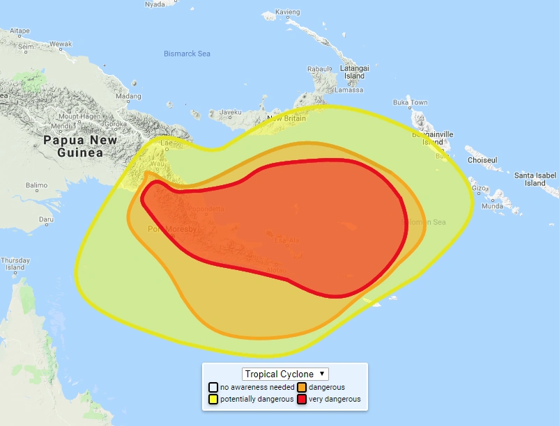
A map produced by the Papua New Guinea National Weather Service on January 15, 2024, showing the likelihood of dangerous conditions from Cyclone Alu. The area of potential danger stretches from southeastern Papua New Guinea to the Treasury Islands, an island group that is part of the Solomon Islands, and Bougainville Island, a large island located directly north of the Treasury Islands
On January 13, shortly after Alu was named by TCWC Port Moresby, Papua New Guinea's National Weather Service issued tropical storm warnings for coastal communities in East New Britain Province, West New Britain Province, and southern New Ireland Province. Later that day, the National Weather Service issued tropical storm warnings for all coastal and inland communities in Milne Bay Province and Central Province and encouraged people in the area to prepare extensively for the storm. Many people heeded this warning; in these two provinces, all businesses and schools, with the exception of designated emergency shelters, were closed, groups of people placed sandbags on beaches, and the vast majority of stores sold all of their supplies. The Government of Papua New Guinea sent food and water to numerous communities on the coast of the Papuan Peninsula. On January 15, following Alu's period of explosive intensification, the tropical storm warnings which had previously been in effect for the islands of New Britain and New Ireland were discontinued; the tropical storm warning which was in effect for Milne Bay Province and Central Province was upgraded to a tropical cyclone warning, and the warned area was extended to include Oro Province. Due to its remarkable and unprecedented rate of intensification, the precautions taken by residents of southeastern Papua New Guinea were largely incapable of protecting them from the storm surge, which reached 25 feet (7.6 meters) in some locations, heavy rainfall, and strong winds caused by Alu; therefore, in Papua New Guinea, damage and loss of life was extensive and catastrophic.
Australia[]
On the afternoon of January 19, approximately two days before Alu made landfall in Queensland as a Category 2-equivalent cyclone on the Saffir-Simpson hurricane scale, the Bureau of Meteorology issued a tropical cyclone watch for the eastern coast of Queensland between Archer River and Cairns. The next day, the tropical cyclone watch for this region was upgraded to a tropical cyclone warning. Before the storm made landfall, local officials evacuated the towns of Yarraden and Coen; Oyala Thumotang National Park and Kutini-Payamu (Iron Range) National Park were evacuated as well. Residents that refused to leave these areas were encouraged to stay inside until the storm passed and it was deemed safe for them to leave. Television and radio stations advised people in Queensland to gather food and water and do whatever they could to protect their houses from structural damage. On January 21, a cyclone watch was issued for the coast of Queensland between Karumba and Nicholson. Early on January 22, the tropical cyclone watch was upgraded to a tropical cyclone warning. Schools in the area were closed for several days as the storm approached the northwestern coast of Queensland. Heavy rainfall from Alu prompted the Bureau of Meteorology to issue a flood warning for much of the Northern Territory.
Impact[]
Papua New Guinea[]
Milne Bay Province[]

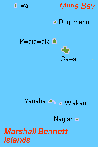
A map of the Marshall Bennett Islands

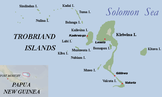
A map of the Trobriand Islands
As a Category 5-equivalent cyclone on the Saffir-Simpson hurricane scale, Cyclone Alu passed between the Trobriand Islands and the Marshall Bennett Islands. A 22 ft (6.1 m) storm surge inundated much of Kiriwina Island, Vakuta Island, Kaileuna Island, Kitava Island, and Muwo Island, killing 214 people and leaving 21 people missing. Most of the casualties in the Trobriand Islands occurred in small communities along the coast of Kiriwina Island and Kitava Island. Every building in Obomatu Village, which was located on Iwa Island, was destroyed by storm surge and 1-minute sustained winds of around 180 mph (290 km/h). Although it can not be confirmed, it is likely that all of the village's 832 residents perished in the storm. A fishing outpost on Dugumenu Island was significantly damaged by heavy rainfall from Alu; fortunately, nobody was on the island at the time. Severe flooding occurred on Kwaiawata Island, Gawa Island, and Yanaba Island. Rainfall in the Trobriand Islands peaked at 31.39 inches (797 mm) in Kaibola; rainfall in the Marshall Bennett Islands peaked at 39.83 inches (1012 mm) in Obomatu Village. Damage in the Trobriand Islands was estimated at US$10 million, while damage in the Marshall Bennett Islands was estimated at US$3 million. The highest wind gust associated with Alu, 212 mph (340 km/h), occurred on Kaileuna Island on January 15.
On Woodlark Island, due to hourly rainfall rates of nearly 5 inches (127 mm), several streams and rivers overflowed their banks. Storm surge from Alu led to 23 casualties there. The majority of these deaths occurred on the western side of the island. On Madau Island, 9 people died. Strong winds felled trees and damaged roofs in the town of Kulumadau. 1 person was killed in the village of Guasopa when they were hit with debris. Damage in Woodlark Island was estimated at US$3 million.
The D'Entrecasteaux Islands, which are located near the northern coast of Milne Bay Province, were significantly affected by Alu. Most locations in the archipelago received 40–70 inches (1016–1778 mm) of rain in a 3-day period. Some locations on Normanby Island and Goodenough Island received 71–100 inches (1803–2540 mm) of rain in the same amount of time; rainfall peaked at 114.87 inches (2918 mm) near the summit of Mount Vineuo, the highest peak of the D'Entrecasteaux Islands. This heavy rainfall caused flash flooding and landslides which killed over 500 people. Esa'Ala was one of the most heavily affected towns in the archipelago; every building in the town was either damaged or destroyed. Several villages on Sanaroa Island and Fergusson Island were almost entirely destroyed by flooding from Alu as well. 1-minute sustained winds of 185 mph (300 km/h) and wind gusts of up to 205 mph (330 km/h) downed approximately 2000 trees on Normanby Island alone; this island was also devastated by a 24-foot (7.3 m) storm surge, which traveled as much as 8 miles (12.9 kilometers) inland, caused severe beach erosion, and killed approximately 200 people. 98% of the community of Bolubolu, which is located on Goodenough Island, was submerged due to a mixture of severe flooding and storm surge; 50 fatalities occurred in this village. In total, Alu caused US$10 million in damage and 750 fatalities in the D'Entrecasteaux Islands.
Alu caused cataclysmic damage and loss of life in mainland Milne Bay Province. Many communities along both the northern coast of Milne Bay Province and Milne Bay itself experienced a storm surge of around 25 feet (7.62 m). This large storm surge devastated several villages and towns. The village of Iapoa, which lies northeast of Alotau, was nearly completely obliterated; while every house was damaged to some degree, only 2 houses were not destroyed. The Tawali Resort, which is located near the eastern edge of mainland Milne Bay Province, was swept away by storm surge; 120 people, many of whom were tourists, were killed. Alotau, the capital of Milne Bay Province, reported significant damage and extensive loss of life due to storm surge from Alu; this storm surge penetrated approximately 10 miles (16 kilometers) inland, inundating much of the town. 90% of buildings in Alotau were either damaged or destroyed. In Alotau alone, 848 people were killed and 477 were reported missing as a result of storm surge alone. Government buildings in the town were closed for over six months after the storm due to the severity of the damage. Several other communities, such as Gibara, Ginewa, and Awaiama, were severely damaged by storm surge. Storm surge caused US$100 million in damage in mainland Milne Bay Province.
Alu brought substantial rainfall to much of mainland Milne Bay Province; 30-50 inches (762–1270 mm) of precipitation fell on a large swath of the province. Even after the core of Alu traveled away from Papua New Guinea, the outer rainbands of the storm dropped another 5-10 inches (127–254 mm) of precipitation on much of southeastern Papua New Guinea. Rain totals of around 60 inches (1524 mm) were prevalent in Milne Bay Province. This massive amount of rainfall caused widespread and severe flooding which killed approximately 600 people. The western portion of Milne Bay Province was particularly hard hit by flooding caused by Alu; entire communities were washed away by floodwaters and the stability of the rainforest ecosystem in the area was disturbed by excessive rainfall and the aforementioned severe flooding. The interior of Milne Bay Province experienced mostly ecological damage as a result of Alu. The main reason for this lack of damage to structures and settlements throughout much of Milne Bay Province's interior is its low population; as well as this, many communities in this area are relatively small. The eastern portion of mainland Milne Bay Province was also greatly affected by Alu. The town of Alotau, which was damaged by storm surge as well, experienced significant flooding that killed 544 people. The communities of Gibara, Gaduda, and Loani were affected by flooding as well; in Gibara, 23 people were killed, while 3 people were reported missing; in Loani, 10 people were killed, while 5 people were reported missing; in Gaduda, 7 people were killed, while 5 people were reported missing. 7 people were killed as a result of consuming contaminated floodwaters; the floodwater became contaminated as a result of it mixing with toxins from dumping grounds used by several overseas companies. Over 150,000 people were left homeless in the wake of Alu; much of these people lost their houses as a result of flooding. Flooding from Alu caused US$70 million in damage in mainland Milne Bay Province.
1-minute sustained winds of 150 mph (240 km/h) caused substantial damage throughout mainland Milne Bay Province and downed hundreds of power lines and trees. In Alotau, these winds tore roofs off houses and picked up and carried debris from destroyed buildings. 3 people were killed in the community of Daudau when a tree fell on them. 1 person was killed in Alotau when a piece of plywood broke the windshield of their automobile and hit them in the head. The highest wind gust in mainland Milne Bay Province that was associated with Alu, 183 mph (~295 km/h), was recorded near the village of Loani. High winds from Alu caused US$50 million in damage in mainland Milne Bay Province. Overall, in mainland Milne Bay Province, 2,233 people were killed, while 490 people were reported missing.
Central Province and Port Moresby[]

.jpg)
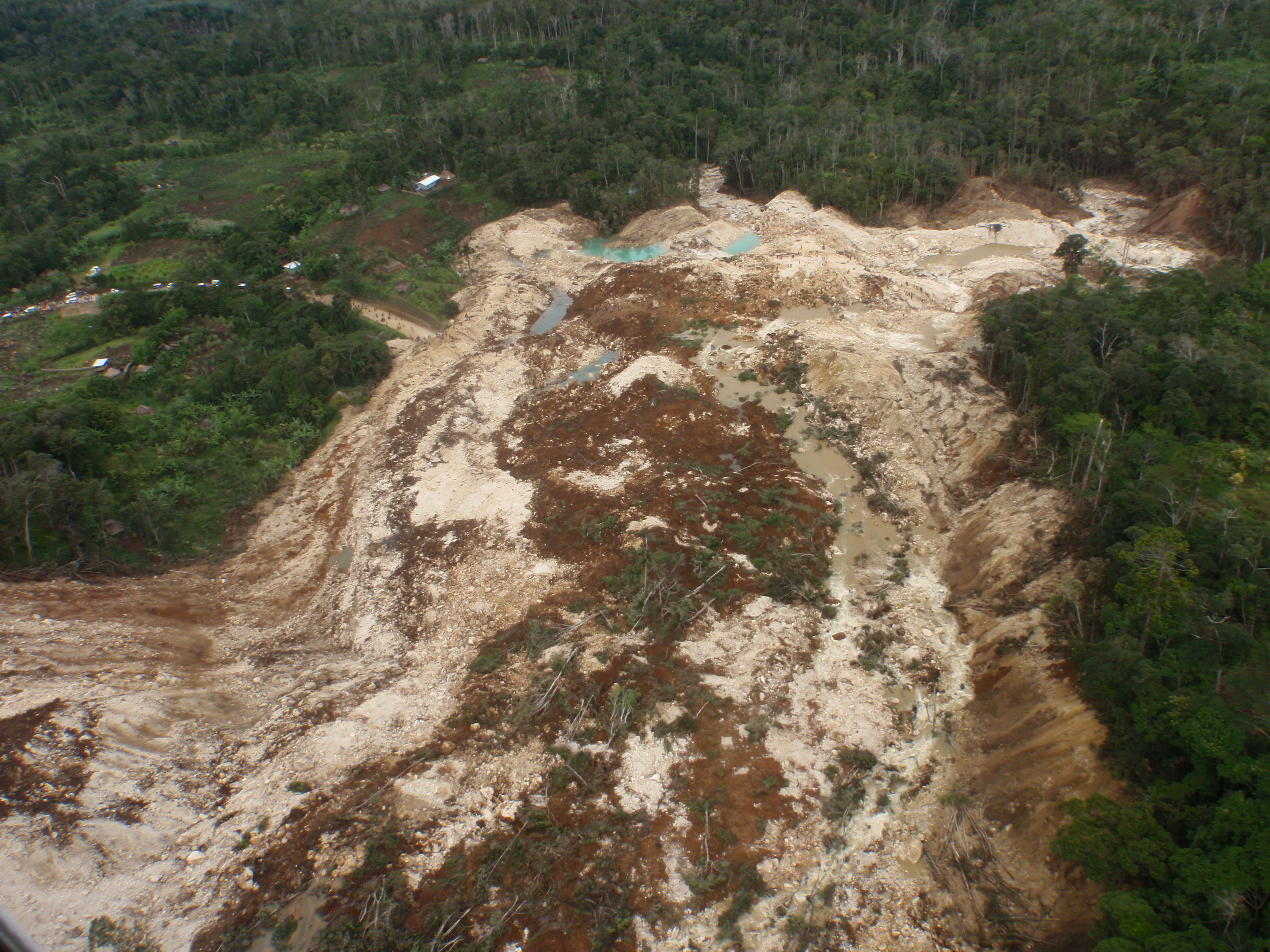
A picture of a large landslide that occurred in Central Province on January 17, 2024
As a result of extremely heavy rainfall, which peaked at 24.31 inches (617 mm) near the border of Milne Bay Province and Central Province, Alu caused widespread flooding in eastern Central Province. Due to this flooding, 19 people were killed and 5 people were reported missing. Because much of this area is sparsely populated, little structural damage was reported; thousands of trees were felled by strong winds, however. Over forty landslides occurred around the village of Magarida in a three-day period. A particularly large landslide, which occurred near the village of Magaubo, killed 6 people and damaged 10 houses.
The outer rainbands of Alu caused flooding in both western Central Province and Papua New Guinea's capital, Port Moresby. In the western portion of Central Province, flooding caused 3 deaths. 9 people were reported missing after their house collapsed and was carried away by floodwaters. The Kemp River overflowed its banks as a result of excessive rainfall, submerging large parts of many communities along the river. 5 people were killed after they were swept away by the river near the village of Boregaina. In Port Moresby, rainfall peaked at 11.34 inches (288 mm). Nearly every government building in the city was closed for four days after the storm. In total, 10 people were killed in the city due to flash flooding. Gusty winds and steady rainfall damaged 120 houses and destroyed 15.
Oro Province[]
The eastern portion of Oro Province was affected by the periphery of Cyclone Alu. Localized flooding occurred as a result of heavy rainfall, which peaked at 10.83 inches (275 mm) near Mount Suckling. 10 people were reported missing when they were swept away by floodwaters near the border of Oro Province and Milne Bay Province. 8 people were killed in the town of Tufi after their house collapsed on them. Flash flooding in the village of Uiaku resulted in 18 fatalities. Gusty winds damaged several houses in the village of Gavida; otherwise, the western portion of Oro Province was largely unaffected by Alu. In total, Alu caused 26 fatalities and US$5 million in damage in Oro Province.
The Islands of New Britain and New Ireland[]
In its formative stages, Alu brought heavy rainfall to the southern portion of the island of New Ireland, causing widespread flooding. Many roads were rendered impassable due to landslides, making communication between communities on the island much harder; as a result of this isolation and a lack of hygiene following the storm, a small-scale disease outbreak occurred in the towns of Lamassa and Kabaman; this outbreak killed 83 people in total. 4 people died in the community of Bakop when their house was destroyed by flood waters. 7 people were reported missing in Lambom when they tried to surf on high waves produced by Alu. Despite an extensive search and rescue mission, their bodies were never found. The northern portion of New Ireland only experienced light rainfall as a result of the storm.
New Britain, a large island located near New Ireland, experienced heavy rainfall due to Alu as well. Approximately 10,000 people were evacuated from Kokopo, the capital of East New Britain Province, as rising floodwaters destroyed several houses on the eastern side of the town. Minor beach erosion occurred along the eastern coast of New Britain. As a tropical storm, Alu's rainbands produced hurricane-force wind gusts in and brought steady rainfall to southern New Britain, causing 14 fatalities and US$30 million in damage. After Alu's explosive intensification, thunderstorms, which were fueled by moisture from Alu, dropped rainfall in excess of 7 inches (178 mm) on parts of New Britain and New Ireland. This exacerbated flooding and hindered relief efforts on both of these islands.
Australia[]
Queensland[]

Cyclone Alu making landfall in Queensland early on January 21
A 12 ft (3.7 m) storm surge caused significant beach erosion in northeastern Queensland. Rainfall from Alu in Queensland peaked at 20.63 inches (517 mm) near Mount Mulgrave; flash flooding occurred throughout much of the Cape York Peninsula as a result of widespread rain totals of 10-15 inches (254–381 mm). Loss of life in this region was relatively minimal as a result of the region's low population and Australia's generally effective warning system. However, the amount of damage was relatively high. Rainbands from Alu caused US$30 million in damage in Cairns; as well as monetary damage, 1-minute sustained winds of around 100 mph (160 km/h) and rain squalls damaged several houses. The Archer River overflowed its banks, submerging portions of communities along the river and causing US$1 million in damage. Around US$800,000 in damage was reported in the communities of Yarraden and Coen. The Great Barrier Reef, which is located along the coast of northeastern Queensland, was damaged by Alu as well. Minor damage occurred in western Queensland; most of the damage occurred near the communities of Burketown and Nicholson. Several national parks in the Cape York Peninsula were flooded due to heavy rain from Alu. Overall, Alu caused 3 deaths and US$51.2 million in Queensland. All of these deaths occurred when a house collapsed on a family in Laura.
Northern Territory[]
Alu traveled through much of the Northern Territory as a weakening tropical low. Shortly before it passed near the community of Ampilatwatja, however, Alu degenerated into a remnant low; this remnant low persisted for several days before dissipating completely near the town of Tarcoola in the state of South Australia. The majority of damage caused by Alu in the Northern Territory occurred as a result of heavy rainfall, which caused flash flooding that damaged houses in the towns of Alice Springs, Borroloola, and Yuendumu, among others. Wind gusts of up to 57 mph (90 km/h) slightly damaged several mobile homes, trees, and power lines. Fortunately, the storm and its potential effects in the Northern Territory were well-forecast; because of this, no one was killed here. Flooding and gusty winds from Alu caused US$50 million in damage; much of this damage occurred in Alice Springs.
Elsewhere[]
As a tropical storm on the Saffir-Simpson hurricane scale, Cyclone Alu brought light rainfall to the Solomon Islands, causing minor flooding and soil erosion.
Aftermath[]
Papua New Guinea[]
Effects on Papua New Guinean Politics[]
Cyclone Alu had a profound impact on politics in Papua New Guinea. On June 21, 2024, members of the National Alliance Party, an influential political party in the nation, accused the Prime Minister, Don Polye, of not doing enough to aid victims of Cyclone Alu; he was also accused of saying that the people affected by the storm "did not deserve to be helped." Because of these claims, many Papua New Guineans protested in the streets of large cities, such as Lae and Port Moresby, calling for Don Polye to resign. Eventually, after a public vote was held to determine whether or not he would be forced to step down, Don Polye willingly resigned from his position as Prime Minister of Papua New Guinea. Don Polye passed away on April 3, 2027.
Several years after Don Polye passed away, a member of the National Alliance Party stated that the claims made against him were completely false. One of the main reasons why the National Alliance Party fabricated this claim was because they believed that Don Polye had turned against them by founding a new party known as the Triumph Heritage Empowerment Party. This revelation led to a political uprising in Papua New Guinea. Members of the National Alliance Party were frequently seen fighting with members of the Triumph Heritage Empowerment Party in the streets of Port Moresby. Over 20 people were killed due to violence related to this uprising. On November 18, 2034, the Government of Papua New Guinea ordered the dissolution of the National Alliance Party. Some former members of the National Alliance Party created the Progress for Papua New Guinea Party, while other former members joined parties such as the Pangu Party.
Relief efforts in Papua New Guinea[]

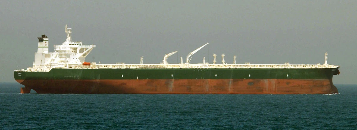
A Japanese oil tanker that is bringing kerosene to Papua New Guinea in the aftermath of Cyclone Alu
Relief efforts in Papua New Guinea were extensive. The Government of Papua New Guinea ordered that farmers had to substantially increase their crop production in order to provide food for the victims of Alu. By the end of 2025, 63 tonnes of food were sent to residents of Milne Bay Province, Oro Province, and Central Province. Charitable organizations, such as United Way Worldwide, The Task Force for Global Health, and Habitat for Humanity International, raised approximately US$4 billion in donations for people affected by the cyclone. Volunteers from the American Red Cross, who arrived in Papua New Guinea only three days after Alu had made landfall there, provided people in the towns of Alotau, Rabaraba, Esa'Ala, and Menapi with blankets, medical kits, and generators.
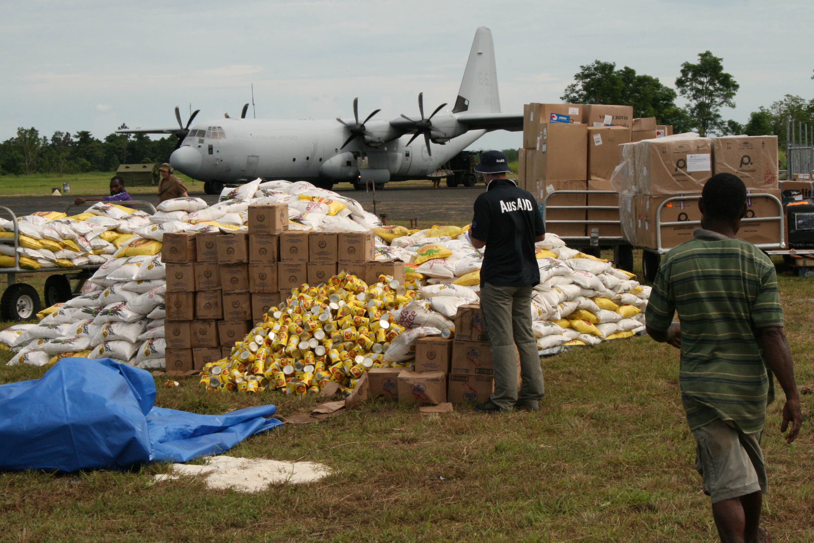

A picture of members of AusAID inspecting a delivery of flour and non-perishable food
Many nations aided residents of southeastern Papua New Guinea. China and Canada sent several tonnes of bottled water, water purification tablets, and timber to residents of the islands of New Britain and New Ireland and the D'Entrecasteaux Islands; Saudi Arabia sent three cargo ships with metal, wet wipes, and mattresses. These materials were distributed to people in Milne Bay Province and Central Province. France sent several military aircraft to the village of Uiaku. Japan and India sent 102 tonnes of kerosene to the towns of Alotau, Gibara, and Lamassa. Malaysia, Thailand, Romania, and Hungary sent soldiers to several small villages in eastern Oro Province. Australia, Russia, South Africa, Spain, Italy, Poland, and the United States joined forces to establish the Papua New Guinea Recovery Fund. Within three months, they had raised US$400 million in total; this money was used to provide clean water, building materials, non-perishable food, and flour for Papua New Guineans impacted by Alu.
Numerous towns and villages were significantly damaged by Cyclone Alu. For example, nearly every building in the town of Esa'Ala, which is located on Normanby Island, one of the largest islands in the D'Entrecasteaux Islands, was destroyed by the storm. In response to this devastation, several nations and volunteer groups offered to help rebuild houses and businesses there. Germany and France, for example, sent volunteers to the area to rebuild houses that were destroyed by Alu and search for survivors. The United Nations Volunteers program encouraged people to become volunteers through advertisements on radio and television stations; as a result of this, over 10,000 people traveled to Papua New Guinea in order to become volunteers. Some of these people built new schools, houses, and businesses in Milne Bay Province, Central Province, and Oro Province, while others repaired damaged buildings.
Volunteer Policy Change in Papua New Guinea[]


An image of Papua New Guinea's National Parliament House, which is located in the city of Port Moresby
On January 26, 2024, Don Polye, the Prime Minister of Papua New Guinea, held a press conference in front of the National Parliament House in Port Moresby. The subject of this press conference was whether a bill should be proposed requiring able-bodied Papua New Guineans to fulfill a volunteering quota of 50 hours every year. During the conference, Don Polye delivered a speech encouraging people to volunteer as much as they can to help their community. The transcript of his speech is as follows:
"Welcome everybody to the National Parliament House. Today, I will be talking about an issue that is prevalent in our country: a lack of volunteers. Especially in the aftermath of Cyclone Alu, we need more volunteers than ever. We can not simply rely on foreign aid to solve this issue; we need brave, homegrown men and women as well. I feel that this nation has grown too complacent, too comfortable. We need to encourage volunteering in whatever way we can. That is why I am proposing this mandatory volunteer work bill: it will benefit our nation and the character of our people. Hard, selfless work can, and will, mold anyone, no matter their race, gender, etc., into a better, kinder person. We need to grow the seed of compassion, selflessness, and valor before it is too late. Without the brave work of volunteers, our nation, along with many others, would be much worse off. Volunteers are essential to a stable nation: they help us in our moments of greatest need. A volunteering quota of 50 hours per year will help us recover from disasters that occur in our country and others. Despite all of the destruction and pain caused by Alu, it has taught me a lesson: we need volunteers in our world."
This speech became extremely popular shortly, both abroad and in Papua New Guinea itself. Many skeptics of the bill were swayed to vote in favor of it after his speech; before the speech, approval ratings of the bill were around 30%; after the speech, however, approval ratings of the bill skyrocketed to around 70%. On January 2, 2025, the bill was signed into law.
Australia[]
In Queensland, severe flash flooding occurred as a result of Cyclone Alu. In response to this, 10 levees were built along the Archer River to minimize the risk of it overflowing due to heavy rainfall. Jetties were built on beaches to protect them from beach erosion. Australia's building code was updated in order to include new regulations that would lessen structural damage from strong winds and storm surge. 50% of the Queenslander papaya and avocado crop was destroyed during Alu. Consequently, the price of both papayas and avocados increased.
Relief efforts in Australia were much less widespread than relief efforts in Papua New Guinea. In northern Queensland, volunteers from New Zealand and Brazil repaired a total of 235 houses that were damaged by Alu. Argentina sent three aircraft to the town of Cairns. The cargo of these aircraft consisted of food, water, and medicine. On February 3, 2024, Australia and Papua New Guinea signed an agreement that stated that they would support each other in the wake of Alu by exchanging natural resources. The Prime Minister of Australia donated AUS$26 million in total to Aboriginal land councils in the Northern Territory.
Records[]

Cyclone Guba near Papua New Guinea on November 16. Cyclone Alu was the first storm to be named by TCWC Port Moresby since Guba
Cyclone Alu formed in TCWC Port Moresby's area of responsibility, which encompasses the area around the country of Papua New Guinea. Tropical cyclones rarely form in this region. Alu was the first storm to be named by TCWC Port Moresby since Severe Tropical Cyclone Guba. Guba was a Category 3 cyclone on the Australian scale that developed in November 2007. It caused severe flooding in southern Papua New Guinea, partly because of its erratic movement.
One of the most notable aspects of Alu was its explosive intensification and intensity. Alu's minimum barometric pressure dropped by 102 millibars in a 30-hour period, surpassing Hurricane Wilma of 2005, which experienced a barometric pressure drop of 100 millibars in 30 hours. This rate of intensification was slightly slower than Super Typhoon Forrest of 1983, however, which experienced a barometric pressure drop of 100 millibars in less than a day. At its peak, Alu had 10-minute sustained winds of 160 mph (260 km/h), 1-minute sustained winds of 190 mph (305 km/h), and a minimum barometric pressure of 892 mbar (26.34 inHg). This made it the strongest cyclone on record in the Australian region. Previously, Cyclone Inigo, which had 10-minute sustained winds of 150 mph (240 km/h), 1-minute sustained winds of 160 mph (260 km/h), and a minimum barometric pressure of 900 mbar (26.58 inHg), held this title.
Due to its slow movement, Alu dropped torrential rainfall on much of southeastern Papua New Guinea, causing landslides and widespread flooding. Mount Vineuo, the highest point of Goodenough Island, received 114.87 inches (2,918 mm) of precipitation in a three-day period; this measurement makes Alu one of the wettest tropical cyclones on record. The main reason for this large amount of rainfall is a process known as orographic lift. This process involves the forcing of air masses to higher elevations, which can create precipitation and clouds.
| Rank | Precipitation (mm) | Precipitation (in) | Storm | Location |
|---|---|---|---|---|
| 1 | 6,433 | 253.3 | Hyacinthe (1980) | Commerson Crater, Réunion, France |
| 2 | 5,512 | 217.0 | Gamede (2007) | Commerson Crater, Réunion, France |
| 3 | 3,429 | 135.0 | Unnamed (1909) | Silver Hill Plantation, Jamaica |
| 4 | 3,060 | 120.5 | Morakot (2009) | Alishan, Chiayi, Taiwan |
| 5 | 2,958 | 116.5 | Diwa (2006) | Grand-Ilet, Réunion, France |
| 6 | 2,918 | 114.87 | Alu (2024) | Mount Vineuo, Papua New Guinea |
| 7 | 2,781 | 109.5 | Fran (1976) | Hiso, Japan |
| 8 | 2,749 | 108.2 | Carla (1967) | Hsin-Liao, Taiwan |
| 9 | 2,550 | 100.4 | Flora (1963) | Santiago de Cuba, Cuba |
| 10 | 2,319 | 91.30 | Nari (2001) | Wulai, New Taipei, Taiwan |
Retirement[]
When a tropical cyclone forms in TCWC Port Moresby's area of responsibility, its name is automatically retired. Because of this policy and the widespread damage and loss of life caused by the storm, the name Alu was retired by the World Meteorological Organization (WMO); it was replaced with Nou, which was the first name on TCWC Port Moresby's standby list at the time.