| Category 4 major hurricane (SSHWS/NWS) | |
| Formed | September 3, 2018 |
|---|---|
| Dissipated | September 16, 2018 |
| (Extratropical after September 15) | |
| Highest winds | 1-minute sustained: 140 mph (220 km/h) |
| Lowest pressure | 937 mbar (hPa); 27.67 inHg |
| Fatalities | 352 direct, 15 indirect |
| Damage | $36.3 billion (2018 USD) |
| Areas affected | Antilles (especially the Dominican Republic), Cuba, The Bahamas, Southeastern United States (especially Florida) |
| Part of the 2018 Atlantic hurricane season | |
Hurricane Gordon was the costliest tropical cyclone of the 2018 Atlantic hurricane season and the most destructive tropical cyclone to strike Florida since Hurricane Irma in 2017. The seventh named storm, third hurricane, and first major hurricane of the 2018 Atlantic hurricane season, Gordon caused widespread devastation in the Antilles Islands, Cuba, Bahamas islands, and the southeastern United States, inflicting a total of $26.3 billion (2018 USD) in damages and causing 129 storm-related fatalities in all affected areas. .
Originating from a tropical wave that emerged off the coast of Africa on August 30, Gordon was classified as a tropical storm on September 3 while east of the Lesser Antilles. It intensified into a hurricane on September 5 and subsequently underwent rapid intensification, becoming a major hurricane on September 7. On September 8, Gordon made its first landfall in the Dominican Republic as a high-end Category 3 hurricane. Gordon then underwent an eyewall replacement cycle, and as a result weakened below major hurricane status on September 9. However, Gordon quickly regained strength and reached Category 4 intensity on September 10. Early the next day, Gordon made landfall over Cape Canaveral, Florida. The hurricane weakened as it passed over Florida, and emerged into the Gulf of Mexico as a Category 3 hurricane. Gordon restrengthened over the warm waters of the Gulf of Mexico, and on September 12 it reached peak intensity shortly before making landfall over Santa Rosa Island. Gordon rapidly weakened as it moved ashore, and by September 13 the hurricane had weakened to a tropical storm while moving over Alabama, and on September 14 became extratropical. The remnants of Gordon continued to accelerate northeast until they were absorbed by a cold front over New York.
Gordon caused widespread destruction throughout its track through the Atlantic Ocean and Caribbean Sea. The Greater Antilles suffered much of Gordon's initial onslaught, with the Dominican Republic being the hardest-hit. Gordon caused over $3.1 billion in damages and killed 275 people on the island. Gordon is widely regarded as the worst tropical cyclone to affect the Dominican Republic since Hurricane Georges in 1998, and is also the costliest natural disaster ever to occur in that country. Gordon passed through the Bahamas with significant impact, causing damage across several islands. Florida governor Rick Scott declared a state of emergency for the entire state, which had suffered a direct hit from Hurricane Irma one year earlier. Overall, Gordon caused a total of at least $35.2 billion in damages and 68 fatalities in the United States.
Meteorological history[]
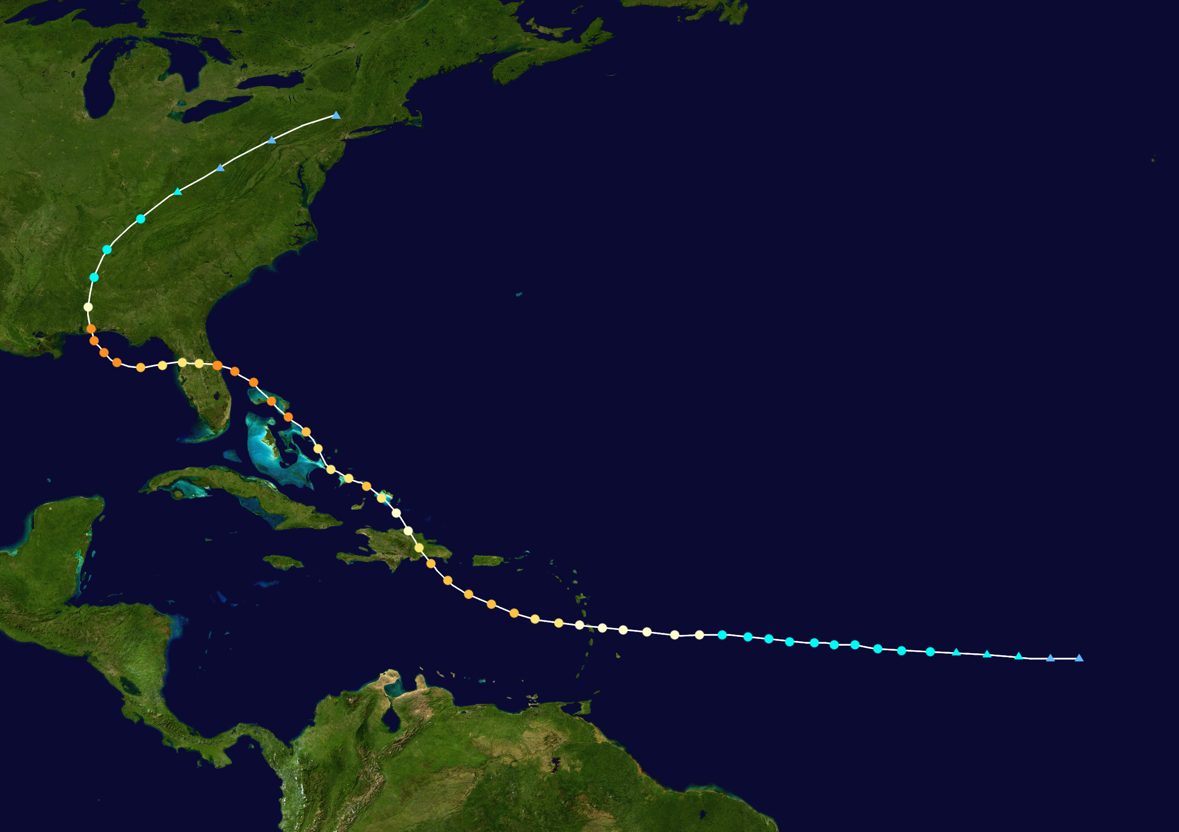

.png)
Map plotting the storm's track and intensity, according to the Saffir–Simpson scale
Tropical storm (39–54 mph, 63–87 km/h)
Category 1 (74–95 mph, 119–153 km/h)
Category 2 (96–110 mph, 154–177 km/h)
Category 3 (111–129 mph, 178–208 km/h)
Category 4 (130–156 mph, 209–251 km/h)
Category 5 (≥157 mph, ≥252 km/h)
A tropical wave emerged off the coast of Africa on August 31 and tracked slowly across the Atlantic. The National Hurricane Center (NHC) noted a high probability that the wave would develop into a tropical cyclone due to warmer than average sea surface temperatures and low wind shear to inhibit development. By September 2, the wave was producing tropical storm force winds, but still lacked a closed center. The NHC classified the system as Potential Tropical Cyclone Eight at 14:00 UTC, and tropical storm watches were issued for portions of the Lesser Antilles. On the morning of September 3, a reconnaissance aircraft reported that the disturbance had developed a closed center, and the system was upgraded to Tropical Storm Gordon.
Continuing westward towards the Caribbean, Gordon steadily strengthened amidst favorable conditions prevented by warm sea surface temperatures and low wind shear. On September 5, Gordon was upgraded to a hurricane based on Dvorak classification and the development of an eye feature. Late on September 6 as it entered the Caribbean Sea, Gordon began to rapidly intensify, becoming a Category 3 hurricane on September 7. A ridge of high pressure over the western Caribbean Sea forced the hurricane to turn to the northwest, prompting the issuance of a hurricane watch for the island of Hispaniola, which was later upgraded to a hurricane warning as Gordon neared the island.
At around 12:00 UTC on September 8, Gordon made landfall 20 miles west of San Pedro de Macoris, Dominican Republic, with maximum sustained winds of 125 mph (200 km/h) and a minimum pressure of 945 mbar (27.91 inHg), making it the strongest tropical cyclone to make landfall in the Dominican Republic since Hurricane Georges in 1998. Gordon weakened to a Category 2 hurricane due to the mountainous terrain in the Dominican Republic. Gordon restrengthened into a major hurricane late on September 8, but then weakened back to Category 2 strength as it began an eyewall replacement cycle.
After Gordon completed the eyewall replacement cycle, it quickly restrengthened, becoming a Category 4 hurricane on September 10 as it moved through the Bahamas. At 03:00 UTC the following day, Gordon made landfall south of Daytona Beach, Florida, with winds of 130 mph (210 km/h). Gordon weakened again as it passed over Florida, but it quickly restrengthened as it entered the Gulf of Mexico. Due to the storm's rather slow forward movement speed, it restrengthened to a Category 4 hurricane and reached peak intensity on September 12 with winds of 140 mph (220 km/h) and a minimum pressure of 937 mbar (27.67 inHg) shortly before making landfall over Santa Rosa Island, Florida. Due to the storm's large size, hurricane force winds were felt from Pensacola to Cape San Blas. Pensacola bore the brunt of Gordon's eyewall as the storm moved ashore. However, Gordon weakened quickly over land, weakening to a tropical storm on September 13. By the next day, Gordon had weakened to a tropical depression as it accelerated northeast, becoming extratropical on September 14. Gordon's extratropical remnants continued to rapidly track northeast until they merged with a frontal system on September 16.
Preparations[]

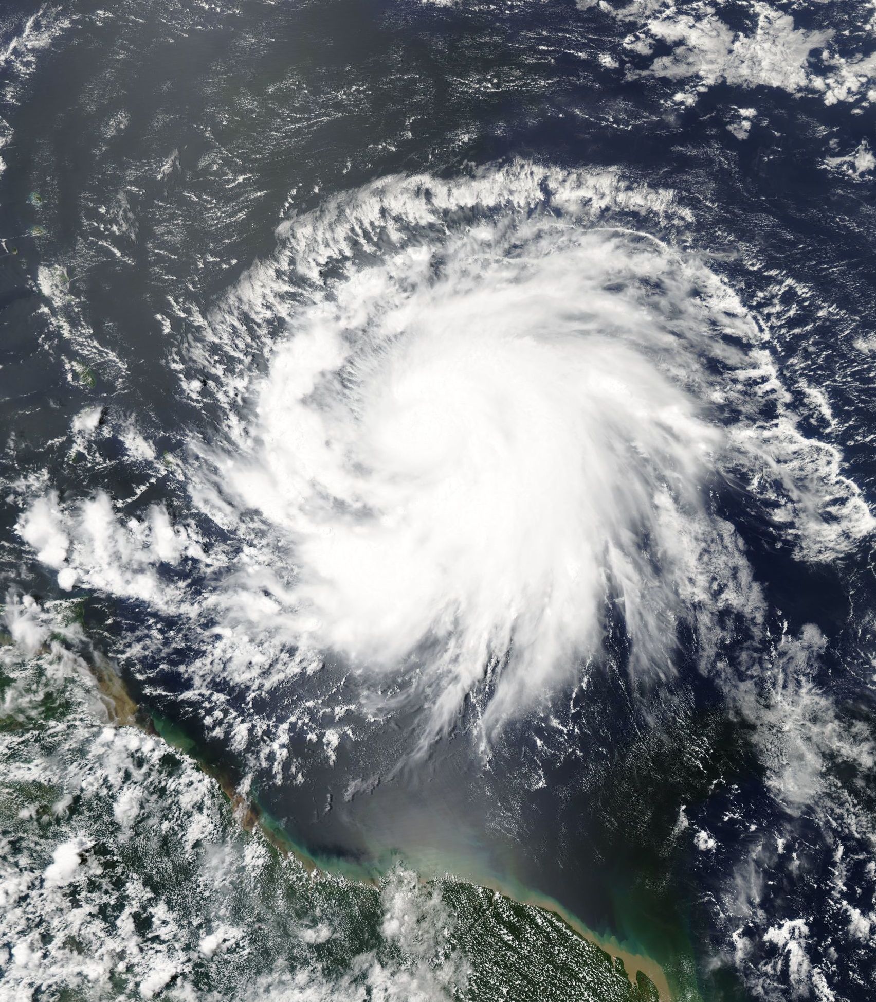
Gordon shortly after being upgraded to a hurricane on September 5
Caribbean[]
On September 4, shortly before Gordon strengthened into a hurricane, LIAT began cancelling flights across the Leeward and Windward Islands in anticipation of hazardous travel conditions expected as a result of the storm. Schools and business throughout the Leeward Islands were closed as Gordon passed through the islands on September 5 and September 6. Tropical storm and hurricane warnings were issued by governments across the Leeward Islands in anticipation of damaging winds.
On September 6, the Dominician Republic activated the International Charter on Space and Major Disasters to provide for humanitarian satellite coverage and assistance with evacuation procedures; Haiti followed suit a day later. Over 15,000 people were evacuated prior to the storm's arrival.
In Haiti, preparations and evacuation efforts were surprisingly well-executed. Government officials stated that well-timed preparations and evacuation procedures saved hundreds of lives that may have been lost had proper preparations and evacuation procedures not been completed.
In The Bahamas, preparations began five days before Gordon's anticipated arrival, with the government fearing that the effects from the storm could be worse than those caused by Hurricane Joaquin nearly 3 prior. By September 9, a day before the storm's arrival, some 2,158 people had been evacuated from the islands.
Mainland United States[]
The NHC issued numerous tropical cyclone watches and warnings throughout the Southeastern United States. The first watches and warnings issued were hurricane watches for a large areaalong the east coast of Florida from Jacksonville Beach to Miami at 14:00 UTC on September 9, due to uncertainty in Gordon's projected path. The hurricane watch was upgraded to a hurricane warning at 19:00 UTC the following day, and tropical storm warnings were issued from Jacksonville Beach to as far north as Hilton Head Island, SC. Tropical storm warnings were also issued from Miami to Key West.
It will replace Gus in the 2024 seaon.