| Category 5 major hurricane (SSHWS/NWS) | |
 Hurricane Hermine on September 15, just after peak intensity | |
| Formed | September 6, 2016 |
|---|---|
| Dissipated | September 19, 2016 |
| Highest winds | 1-minute sustained: 175 mph (280 km/h) |
| Lowest pressure | 902 mbar (hPa); 26.64 inHg |
| Fatalities | 381 total, 2 missing |
| Damage | $34 billion (2016 USD) |
| Areas affected | Cape Verde, Lesser Antilles, Southeastern United States (North Carolina), Midwestern United States |
| Part of the 2016 Atlantic hurricane season | |
Hurricane Hermine was an extremely powerful Category 5 Atlantic hurricane in the 2016 Atlantic Hurricane Season. Hermine was the eighth named storm, fourth hurricane, and second major hurricane of the season. It formed from a tropical wave off the coast of Africa, and became the classic "Cape Verde-type Hurricane", however it turned to the East Coast and made landfall in North Carolina. It formed on September 4 and dissipated on September 19.
Hermine was the first category 5 Atlantic hurricane since Felix in 2007, and the first major hurricane to strike the United States since Hurricane Wilma in October 2005. Hermine was also the strongest storm of the hyperactive 2016 season.
Hermine is the third costliest Atlantic hurricane on record, trailing only Katrina (2005) and Sandy (2012).
Meteorological History[]
.jpg)
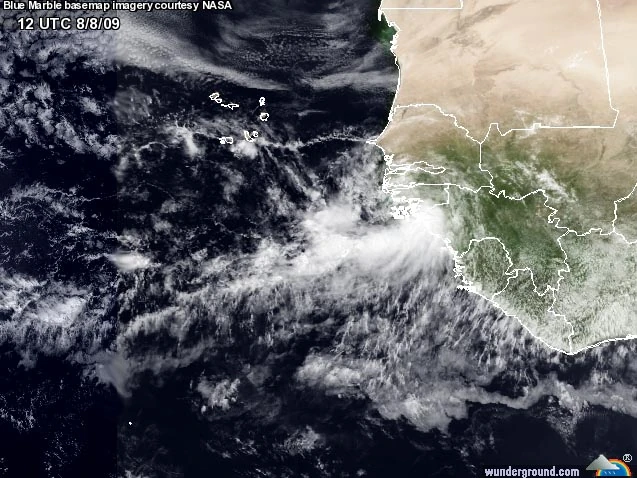
The tropical wave that would eventually become Hurricane Hermine
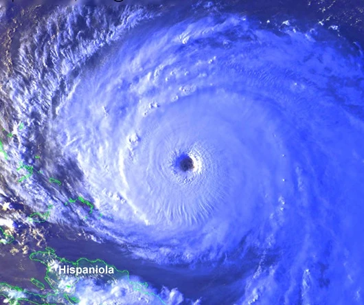
A tropical wave exited the coast of Africa on September 4. Meteorologists began monitoring the wave for possible tropical development. On September 6, Tropical Depression Eight formed about 200 miles east-southeast of the Cape Verde Islands. On September 7, the storm was named Tropical Storm Hermine about 50 miles southwest of the Cape Verde Islands. The storm was expected to gradually intensify over the next week. The NHC forecast, at this time, predicted Hermine to briefly peak as a category 1 before weakening due to suspected wind shear. On September 9, the storm gained Category 1 Hurricane status. Wind shear decreased substantially, creating much more favorable development conditions.The storm quickly intensified to a Category 4 on September 10. The storm weakened slightly later that day to a Category 3 due to an eyewall replacement cycle, but was expected to re-intensify. On September 12, the storm reached the infamous Category 5 on the Saffir-Simpson Hurricane Scale - the first Category 5 Atlantic hurricane in 9 years - with 160 MPH winds. At the next advisory, the storm weakened to 155 MPH winds, a Category 4. At this point, Hermine was about 500 miles east-southeast of Wilmington, North Carolina. Initially, forecasters expected the storm to have no threat to the U.S, as Hermine's forecast cone would have taken it between Bermuda and the East Coast of the United States without making landfall.
.jpg)
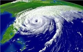
Hermine at landfall.
By September 13, forecasters were unsure about the track of Hermine, with models showing a wide range of possibilities. The GFS model predicted that Hermine would go out to sea, while the European model showed Hermine brushing the United States east coast. Hermine's winds sat at 155 mph for over 48 hours, with weakening predicted to begin by September 14. Unexpectedly, the storm then re-intensified as it entered warmer waters, attaining its peak intensity of 175 MPH winds at 11:00 AM on September 14. At this point, forecasters began to monitor the storm for a United States landfall. The track cone shifted significantly at 5:00pm that evening, with a U.S. landfall predicted instead of a typical Cape Verde hurricane track, despite Hermine's winds being downgraded to 165 mph. On September 15, Hermine was downgraded to a category 4 hurricane, as models began to agree on a U.S. landfall, most likely in the mid-Atlantic states. The storm changed little in intensity over the next 48 hours. By September 16, the storm was expected to make landfall in southeastern North Carolina, most likely as mid-range Category 4. On September 17, Hermine made landfall in southeastern North Carolina as a Category 4 hurricane with 150 MPH winds at the eyewall of the storm.

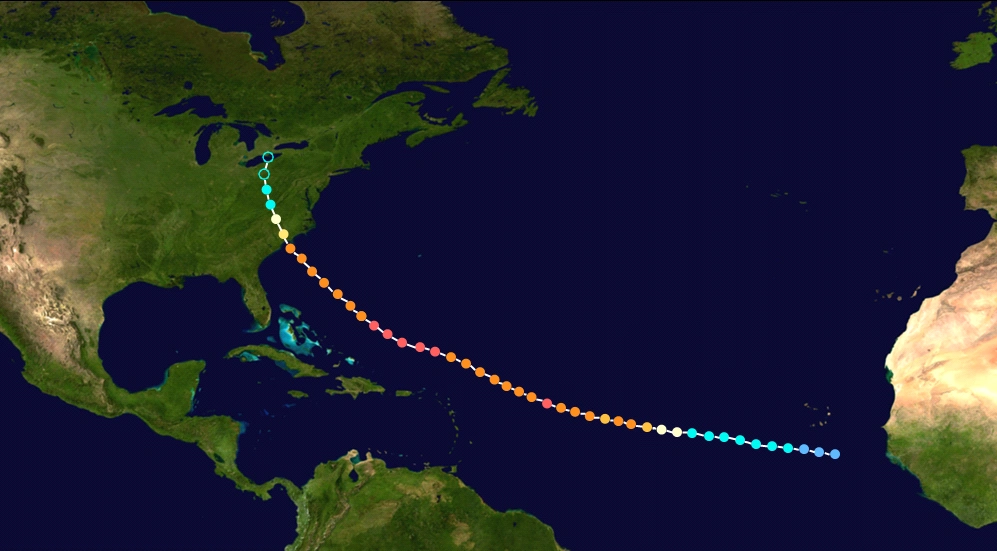
The track of Hermine.
After landfall, Hermine moved north-northwestward. It passed over the main populated part of the state while still a Category 1 hurricane. The storm then quickly weakened over land, dissipating on September 19 near Ohio.
Aftermath[]
Hurricane Hermine was compared to Hurricane Hazel of 1954, which took a similar path; however, Hermine was stronger and deadlier than Hazel.
Impacts of Hermine stretched from South Carolina all the way up into Ohio. Extreme flooding occurred throughout most of North Carolina. Most of North Carolina reported over 5 inches of rain on September 17 due to the storm, even in the mountains.
Hermine caused 277 direct fatalities and 104 indirect fatalities, most of which were in North Carolina. The storm became the deadliest and costliest North Carolina storm on record, and the third-costliest Atlantic hurricane, surpassed by only Katrina and Sandy.
On April 10, 2017, the National Hurricane Center retired the name Hermine, replacing it with Hailey for the 2022 Atlantic Hurricane Season.
Preparations[]
On September 16, North Carolina Governor Pat McCrory and South Carolina Governor Nikki Haley both ordered a State of Emergency for their entire states as the storm approached. Virginia governor Terry McAuliffe followed on September 17.