| Category 5 hurricane (SSHS) | |
|---|---|
| |
| Imelda after striking Guadaloupe just after attaining peak intensity. | |
| Formed | September 17, 2019 |
| Dissipated | September 28, 2019 |
| Highest winds | 1-minute sustained: 195 mph (315 km/h) Gusts: 225 mph (360 km/h) |
| Lowest pressure | 895 mbar (hPa); 26.43 inHg (Fourth lowest in the Atlantic basin, on par with Hurricane Rita) |
| Fatalities | 3,409 direct, 1,891 indirect |
| Damage | $83.95 billion (2019 USD) |
| Areas affected | Leeward Islands (particularly Guadaloupe · Saint Croix · Puerto Rico · Dominican Republic · Haiti · Turks and Caicos Islands · Cuba · Bahamas · United States (particularly the Eastern United States) · Canada |
| Part of the 2019 Atlantic hurricane season | |
Hurricane Imelda was an extraordinarily strong, destructive, and powerful Cape Verde type hurricane, and also the most destructive and deadliest hurricane of the 2019 Atlantic hurricane season, devastating the northern Caribbean Islands and the eastern United States from mid-to-late September 2019. Imelda is the costliest tropical cyclone to ever hit Haiti and the Bahamas, and the strongest to make landfall in the basin in terms of sustained winds.
The origins of Imelda can be traced back to a vigorous tropical wave off the coast of Africa. Moving on a general west-northwestward direction, Imelda intensified slowly. However, she underwent a period of rapid deepening and quickly became a Category 5 hurricane, the highest category in the Saffir-Simpson hurricane wind scale. Imelda achieved peak intensity the day after before making landfall over Petit-Bourg, Guadeloupe. Imelda then moved just south of Montserrat and slowed down, making a turn for the northwest. After Imelda's landfall over Guadeloupe, which weakened her, she re-intensified and reached peak winds for the second time before making landfall over Guayama, Puerto Rico, making Imelda the strongest hurricane to make landfall in Puerto Rico and in a United States territory, based on sustained winds.
A weakened Imelda accelerated into the Atlantic Ocean before re-intensifying into a Category 5, slowing down and turning south. Imelda then made landfall east of Le Borgne, Haiti as a strong Category 5, becoming the strongest hurricane to strike Haiti. Imelda weakened and turned to the north again after ravaging Hispaniola. Imelda reintensified to become a minimal Category 4 hurricane before making landfall over the Haiti-Dominican Republic border. Emerging back over the Atlantic as a weak Category 2, Imelda started to reintensify slowly, becoming a strong Category 4 hurricane before ravaging the Bahamas.
Imelda executed a sharp turn and started to head for Southern Florida. Making landfall as a 155 mph hurricane, Imelda weakened and emerged over the Gulf of Mexico as a weak Category 3 hurricane. Imelda started to intensify once again before making landfall east of Pensacola, Florida as a 150 mph hurricane. Imelda started to weaken over land and was absorbed by an extratropical cyclone just south of Lake Erie.
Meteorological history[]
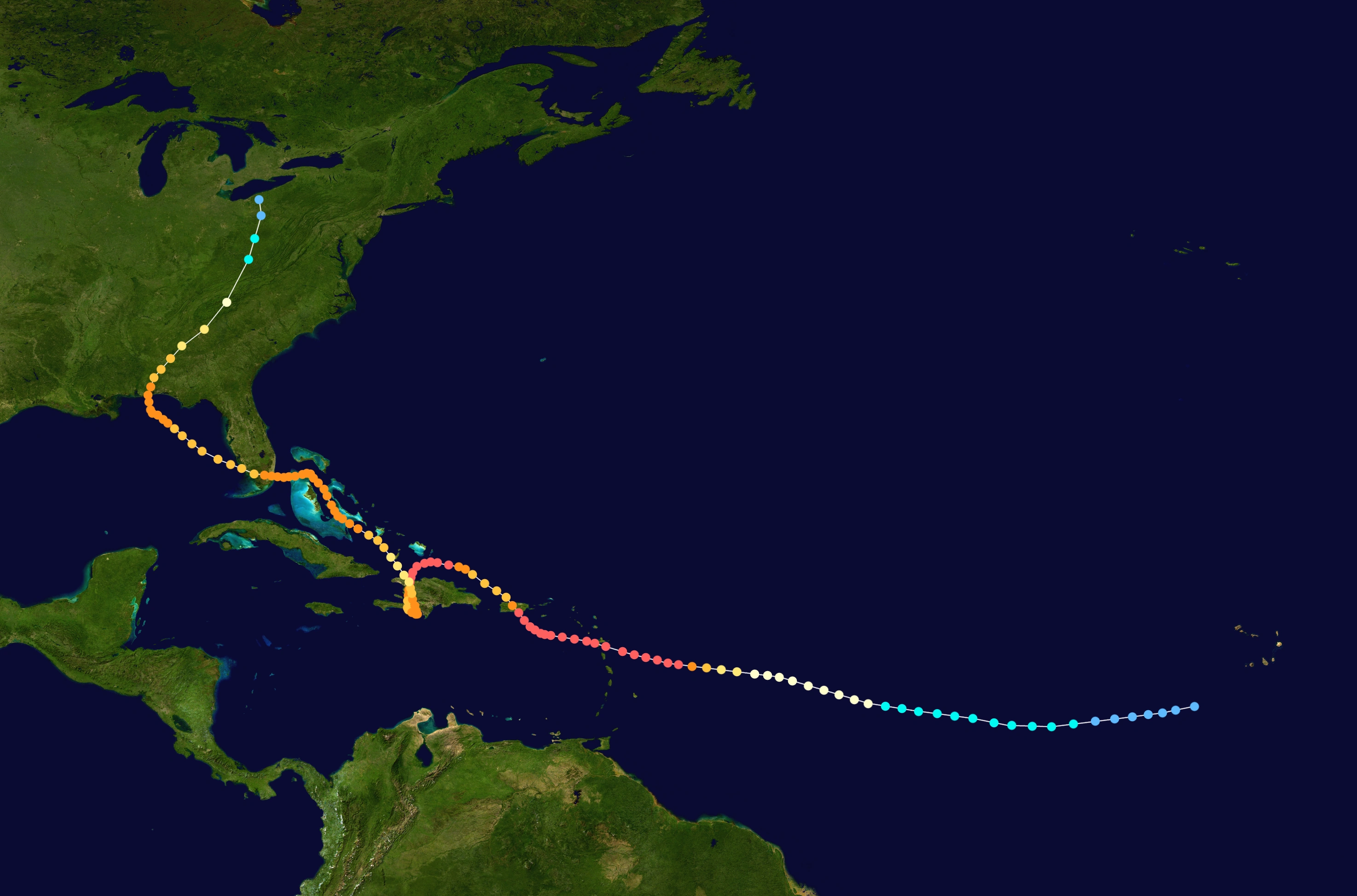
Hurricane Imelda's track through the Atlantic basin.
The National Hurricane Center (NHC) began monitoring a strong tropical wave on September 14 as it moved off of the coast of Africa. The showers and thunderstorms associated with the system gradually coalesced into a low pressure area. Gradually consolidating and organizing, the low pressure acquired a burst of deep convection and became Tropical Depression 10 on September 17. The depression formed at an area of stable atmosphere and dry air, but it gradually organized, aiding from the warm sea surface temperatures below it. The system moved on a west-southwestward position under the influence of an unusually strong subtropical ridge to its north. The depression was forecast to turn north and dissipate, but a break in the subtropical ridge to the north of the system that was forecast to happen due to a trough didn't materialize. The Azores High remained very strong and the depression moved into an environment that is more favorable.
Lowering wind shear, moist air and fairly warm waters aided the system. Satellite images indicated a rigid structure and a strong convection. The Dvorak estimates also indicate that the system has achieved winds of at least 40 mph, and it was assigned the name "Imelda" at 2100 UTC on September 19. A weak trough weakened the influence of the Azores High as Imelda turned to the north and executed a general west-northwestward track. Imelda was forecast to organize and strengthen despite being in an environment with a lack of upper-level-divergence and dry air.
Nearly halfway between the Leeward Islands and Cape Verde, Imelda was upgraded to a hurricane due to the storm's strong poleward and equatorial outflow, organization, and banding at 1900 UTC on September 21. Moving into an area of low wind shear and anomalously high sea surface temperatures, Imelda strengthened. At this point, the only factor preventing Imelda from undergoing rapid intensification is the presence of dry air.
As the Saharan Air Layer weakened, Imelda started to undergo a period of rapid intensification at 1300UTC on September 23. With a very prominent central dense overcast and towering cloud tops with a temperature of around -76°C, Imelda was upgraded to a Category 2 hurricane just hours later, and then a Category 3 hurricane in the next warning. A pinhole eye appeared on Imelda as the hurricane's periphery drastically increased in size; the convection on top of the central dense overcast cooled as well.
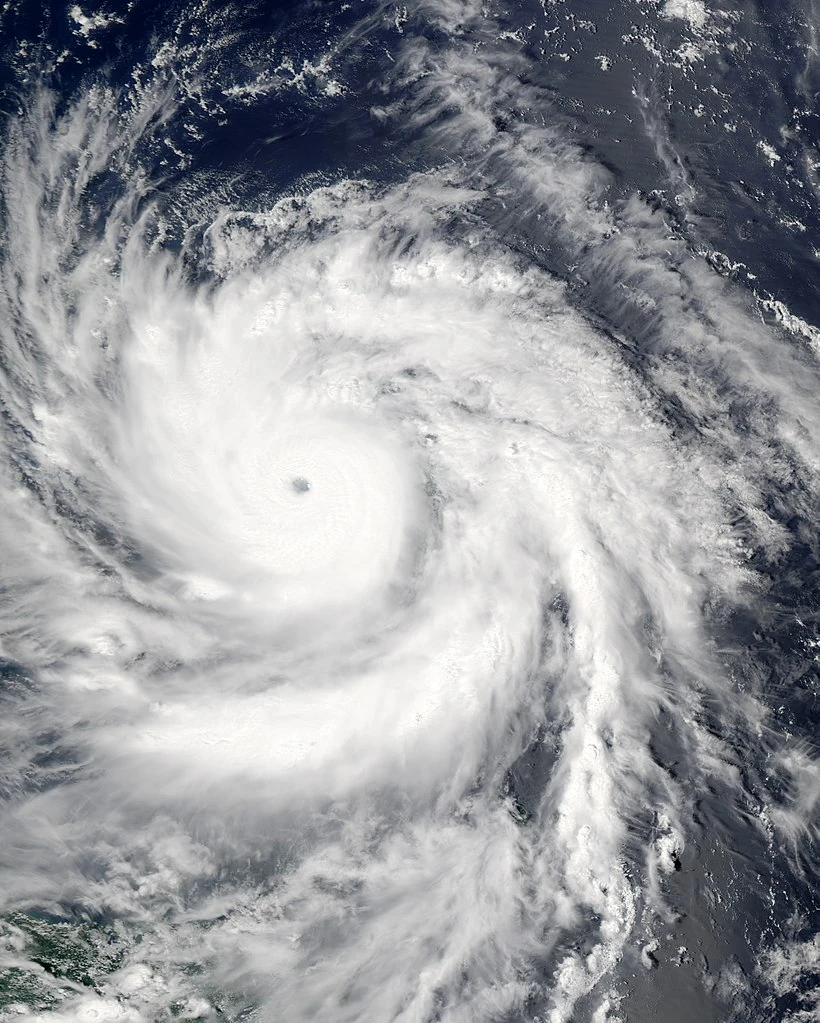
Imelda intensified further, being upgraded to a Category 5 hurricane later. Imelda strengthened before undergoing an eyewall replacement cycle. Imelda weakened briefly before reintensifying, and her eye enlarged. Moving closer and closer to Guadeloupe, Imelda achieved her peak intensity at 195 mph and a pressure of 895 mbars, on par with Typhoon Haiyan six years prior.
Nearly 20 hours later, Imelda made her first landfall on the town of Petit-Bourg, on the island of Basse Terre in Guadeloupe with winds of nearly 185 mph and a barometric pressure reading of 899 mbars. A weather station east of Pointe-a-Pitre recorded a gust of 230 mph and a barometric pressure reading of 902 mbars before being destroyed.
After exiting the island of Basse Terre, Imelda continued moving west-northwest at a slow speed. Imelda was able to intensify while moving south of Saint Croix. Imelda's speed slowed down before recurving to the north. Later, Imelda made landfall over Guayama, Puerto Rico, with winds of up to 190 mph and a barometric pressure reading of 897 mbars. An anemometer in a weather station located in Salinas, Puerto Rico, recorded a wind gust of 214.9 mph before being blown away.
Imelda weakened quickly, exiting Puerto Rico around 12 hours later as a 120 mph Category 3 hurricane. However, moving into a very favourable region, Imelda quickly gathered strength. 36 hours later, Imelda was upgraded to a Category 5 hurricane by the NHC. Moving slowly, Imelda gradually turned southward due to a developing high pressure area between Georgia and South Carolina, barely brushing the Turks and Caicos Islands as a dangerous Category 5 hurricane.
30 hours later, Imelda made landfall east of Le Borgne, Haiti, with winds of up to 185 mph and a barometric
Imelda as a weakened Category 3 hurricane just south of Haiti.
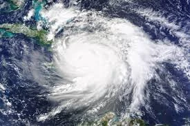
pressure reading of 902 mbars. Imelda dropped torrential rain on Haiti, with some places reporting a copious amount of 70.41 inches of rain. Imelda moved slowly, weakening to a Category 3 hurricane before making landfall over Grand-Goave, Haiti, as a 120 mph hurricane. After reemerging in the Caribbean Sea, Imelda remained very coast to the Hispaniola coast. Restrengthening quickly, Imelda became a 130 mph hurricane before making another landfall over the Haiti-Dominican Republic border. Imelda traversed the entire country of Haiti before exiting Hispaniola as a weakened Category 2 hurricane.
Imelda made landfall over Great Inagua Island as a high-end Category 2 hurricane. Quickly intensifying, Imelda passed just east of the islands of Long Island and Great Exuma. Soon after, Imelda made landfall over New Providence island as a high-end Category 4 hurricane, passing just west of Nassau. Imelda, still a Category 4 hurricane, passed just east of Andros Island, making a sharp turn to the west south of Grand Bahama Island. Imelda started to accelerate for Southern Florida.

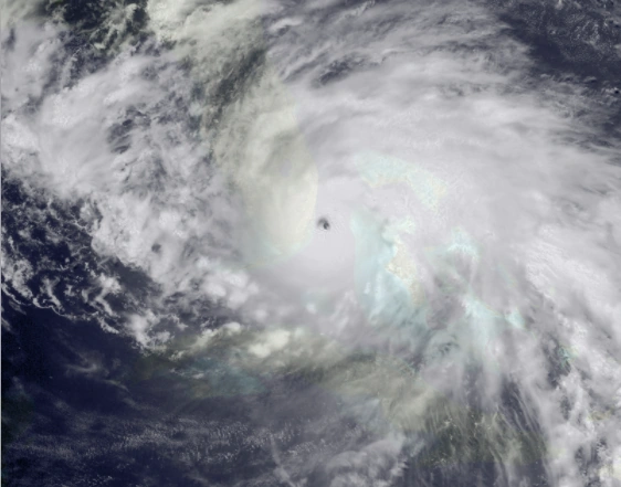
Imelda nearing landfall over Miami-Dade County, Florida.
Over a day later, Imelda made landfall over Miami, Florida with winds of up to 155 mph and a barometric pressure reading of 913 mbars, making Imelda one of the most intense storms to make landfall on the U. S. mainland. Moving slowly, Imelda exited Florida a day after making landfall, entering the Gulf of Mexico. With high ocean temperatures, Imelda was able to strengthen further, despite the presence of wind shear. Imelda's forward speed slowed once again, becoming a Category 4 hurricane. Imelda turned to the northwest and made landfall over Pensacola, Florida as a 145 mph hurricane. Imelda weakened quickly, being downgraded to a tropical storm north of the Appalachian Mountain Range. 18 hours later, Imelda was absorbed by a strong extratropical system that was situated east of Cape Cod, Massachussets. This extratropical cyclone is related with the formation of Cyclone Lawrence in Europe.
Preparations[]
Caribbean[]
Although Imelda was originally anticipated to turn north and brush the Leeward Islands, flights were cancelled in the islands of Saint Martin, Antigua, Barbuda, the Virgin Islands, Saba, and Montserrat. However, as the Bermuda High strengthened, hurricane warnings were issued in a majority of the Leeward Islands. Residents piled up on food and water and hurried to evacuation shelters in anticipation of a direct hit from an extremely dangerous Imelda.
Puerto Rico declared a state of emergency as Imelda battered Guadeloupe. As Imelda approached, Puerto Ricans, previously battered by Irma, Maria, and Nadine the years prior, hurriedly stocked up on food and clean water. In a mere day, supermarkets and grocery stores were left empty, Over 50 shelters opened all around the island. Food rations, medical supplies, toiletries, and blankets were distributed all across the islands. Residents boarded up their homes, anticipating high winds. Residents from the coastal areas arranged sandbags around their homes in fear of a high storm surge. People from low-lying and cliff-edge homes, particularly in the areas around the southeastern side, were evacuated. Tourists and civilians from neighboring islands were transported to Puerto Rico.
Dominican Republic, expecting a direct hit from Imelda, a hurricane warning was issued for the entire northern and eastern seaboards, and a small part of the southern seaboard. People, especially those living in or near hills and mountains, were evacuated and asked to stay in shelters. 10,800 tourists were taken away from resorts and taken to Santo Domingo in the storm's wake, in hopes of keeping them safe.
Haiti, unlike Dominican Republic, did not initially expect a direct impact from Imelda, and was thus fairly unprepared and overwhelmed when Imelda arrived. Despite this, a hurricane warning was issued for the entire northern and northwest coasts. The United States donated food rations, clean water, toiletries, and blankets to Haiti before the storm struck. Plenty of tourists were taken away from the northern coast, seeking refuge in the city of Gonaive. However, the residents overall did not prepare as much as the people from Dominican Republic as they were not initially expecting a direct impact from Imelda.
Cuba was spared from the brunt of Imelda's high winds and torrential rain. However, a hurricane warning was issued for the provinces of Holguin, Guantanamo, and eastern Santiago de Cuba.
The Bahamas[]
Bahamas was caught off-guard by Imelda's power. Forecasts initally predicted Imelda to move quickly through the area as a Category 3 or 2 hurricane. However, sea surface temperatures were warmer than expected and wind shear dropped as Imelda moved through the area.
Before Imelda impacted the islands, a hurricane warning was issued for the whole country. Residents started to pile up on food, shelter, and water, and people from smaller islands were moved to larger islands. Prime Minister Hubert Minnis declared a national state of emergency as schools and airports all over the islands closed. Bahamas also moved some 15,000 tourists to New Providence island, and some 1300 others to the United States.
Florida[]
TBA
Other areas[]
TBA
Impact in the Lesser Antilles[]
Guadeloupe[]
Guadeloupe suffered tremendous damage and loss of life in Imelda's wake. Torrential rainfall ahead of the hurricane resulted in several landslides as the island experienced increasing water levels. A day later, Imelda made landfall over Petit-Bourg, Guadeloupe with winds of 185 mph. Aside from a few severely battered structures, no structure was left standing in Petit-Bourg, which witnessed a 15-foot high storm surge. The northern eyewall grazed Baie-Mahault and Pointe-a-Pitre. The winds, the strongest to ever hit the island, battered nearly every home in Guadeloupe. Both Baie-Mahault and Pointe-a-Pitre experienced a storm surge of up to 12 feet in some areas, inundating entire residential and commercial areas. Downing radio, internet, and cellular services, Guadeloupe was virtually cut off from the outside world, and conditions in the island remained unclear for several weeks. President of the Department of Council Josette Borel-Lincertin described the destruction in the archipelago "immense and apocalyptic." According
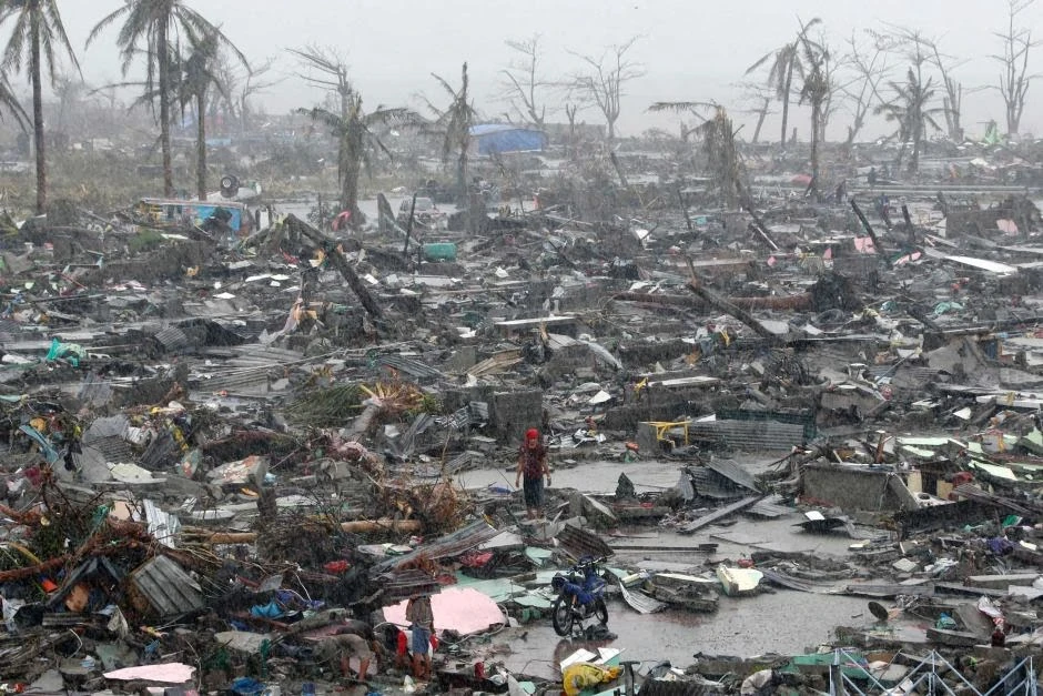

Few structures remain standing as Imelda leaves the islands of Guadeloupe.
to her, recovery may take years to complete.
As the next morning came, the first aerial images of Guadeloupe surfaced. Entire neighborhoods were flattened, and streets were left littered with debris. Many dwellings were left uninhabitable, and floods and landslides littered major roads and highways with more debris. The hurricane also inflicted major damage to public establishments like schools, churches, and stores. All three airports in the islands saw extensive damage, making delivery of goods nearly impossible.
Aside from Petit-Bourg, the towns and cities of Baie-Mahault, Pointe-a-Pitre, and Deshaies suffered from catastrophic damage.
TBA