| Category 2 hurricane (SSHWS/NWS) | |
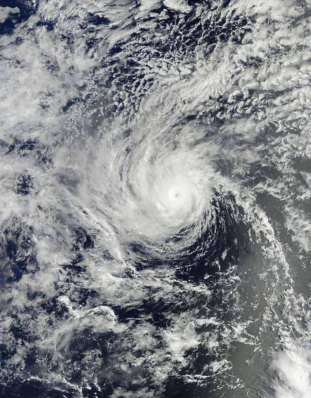 Hurricane Karen shortly after its peak intensity near Bermuda on October 2 | |
| Formed | September 28, 2019 |
|---|---|
| Dissipated | October 8, 2019 |
| (Remnant low after October 5) | |
| Highest winds | 1-minute sustained: 100 mph (155 km/h) |
| Lowest pressure | 982 mbar (hPa); 29 inHg |
| Fatalities | 15 total |
| Damage | $273 million (2019 USD) |
| Areas affected | Bermuda, Newfoundland |
| Part of the 2019 Atlantic hurricane season | |
Hurricane Karen was a strong Category 2 hurricane that struck the islands of Bermuda and Newfoundland. The eleventh tropical storm and sixth hurricane of the 2019 Atlantic hurricane season, Karen formed a low pressure area in the open ocean on September 28. Although it was designated as a tropical storm immediately after it formed, it didn’t became a hurricane until October 1st. It later intensified into a Category 2 and on October 2, it reached its peak intensity with 100 mph (155 km/h) winds and a pressure of 982 mbar. A few hours later, it made a direct hit on Bermuda, weakening to a Category 1 12 hours later and then to a tropical storm on October 4. It then struck Newfoundland the next day, transitioning into a extratropical cyclone shortly after.
Karen caused $273 million (USD) and 15 deaths, 9 were killed in Bermuda and 6 were killed in Newfoundland. Bermuda suffered during this storm, buildings and boats damaged, electricity out for a couple days. Karen was the first tropical cyclone to strike Newfoundland while remaining tropical since Maria of 2011. Newfoundland had heavy gusts and rain that caused moderate flooding.
Meteorological history[]
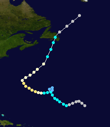
Map plotting the storm's track and intensity, according to the Saffir–Simpson scale
Tropical storm (39–54 mph, 63–87 km/h)
Category 1 (74–95 mph, 119–153 km/h)
Category 2 (96–110 mph, 154–177 km/h)
Category 3 (111–129 mph, 178–208 km/h)
Category 4 (130–156 mph, 209–251 km/h)
Category 5 (≥157 mph, ≥252 km/h)
A low pressure area formed on September 25, heading northwest. It was recognized by the NHC that following day, giving it a low chance of forming. It then after being recognized, abruptly organized over slightly warm waters. On September 27 12:00 UTC, the NHC quickly designated it as Potential Cyclone Twelve, after it was given an 80% chance of forming. It eventually became a tropical storm the next day, the NHC naming it Karen.
It slowly turned northwest as it remained a tropical storm for a couple of days. On September 30 00:00 UTC, it weakened to a tropical depression, now beginning to loop around. The next day, it completed its small loop and that same time, intensified back into a tropical storm, now curving slightly toward the island of Bermuda. On October 1st 00:00 UTC, it strengthened into a Category 1 hurricane and then 12 hours later, it further intensified into a Category 2. On October 2 00:00 UTC, it reached its peak intensity with sustained winds of 100 mph (155 km/h) and a minimum pressure of 982 mbar. 6 hours later, it made a direct hit on Bermuda while holding on to this intensity.
After its direct hit, it gradually weakened due to cooler waters, becoming a Category 1 12 hours later. Then, it abruptly turned northeast. Despite those cooler waters, it didn’t transition into an extratropical cyclone yet. On October 4 06:00 UTC, it weakened to a tropical storm, heading now north-northeast toward the big island of Newfoundland. On October 5 00:00 UTC, it eventually made landfall there, quickly transitioning into an extratropical cyclone a few hours later.