| Category 4 major hurricane (SSHWS/NWS) | |
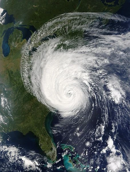 Hurricane Rene at peak intensity impacting the United States on December 25 | |
| Formed | December 22, 2020 |
|---|---|
| Dissipated | December 29, 2020 |
| (Remnant low after December 27) | |
| Highest winds | 1-minute sustained: 145 mph (230 km/h) |
| Lowest pressure | 934 mbar (hPa); 27.58 inHg |
| Fatalities | 3024 direct, 1153 indirect |
| Damage | $22.73 billion (2020 USD) |
| Areas affected | Southeastern United States, New England, Canada |
| Part of the 2020 Atlantic hurricane season | |
Hurricane Rene, also known as The Hurricane that Ruined Christmas, was an extremely rare Category 4 hurricane that formed off-season and impacted the eastern United States. It was the eighth-deadliest hurricane and the strongest off-season storm in the Atlantic on record. The final system of the 2020 Atlantic hurricane season, Rene originated from a tropical low that formed on December 16. It meandered in the open Atlantic for a few days, showing no change in organization. The low organized on December 20, despite cooler waters. On December 22, it developed into a tropical depression and then 36 hours later, became a tropical storm. On December 23, the waters suddenly exploded in temperature, reaching up to 85 degrees F. At that time, the storm very rapidly intensified and by December 24, was already a major hurricane. 6 hours later, it reached Category 4 strength and started to threaten the U.S. On December 25, it reached its peak intensity, with sustained winds of 145 mph (230 km/h) and a central minimum pressure of 934 mbar (hPa).
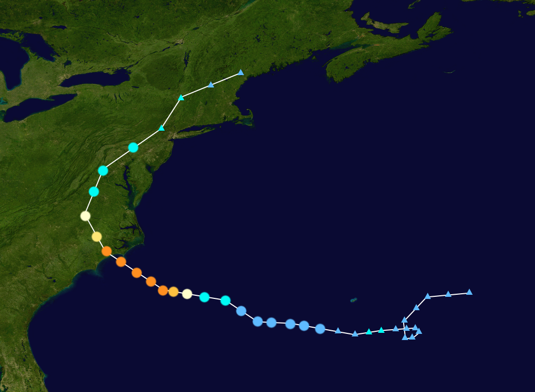
Meteorological history[]

Map plotting the storm's track and intensity, according to the Saffir–Simpson scale
Tropical storm (39–54 mph, 63–87 km/h)
Category 1 (74–95 mph, 119–153 km/h)
Category 2 (96–110 mph, 154–177 km/h)
Category 3 (111–129 mph, 178–208 km/h)
Category 4 (130–156 mph, 209–251 km/h)
Category 5 (≥157 mph, ≥252 km/h)
An area of low pressure formed on December 16 over cool waters. Over the next few days, it meandered the Atlantic, seeing no change in organization. On December 20, it started to organize, despite the cooler waters. On December 22 at 06:00 UTC, it was upgraded to Tropical Depression Twenty, moving westward and gradually strengthening. On December 23 at 18:00 UTC, it was upgraded to a tropical storm, the NHC naming it Rene.
At that time, the temperatures very rapidly and abruptly rose, allowing the storm to rapidly intensify as well. At 06:00 UTC the next day, it strengthened into a hurricane and then just 12 hours later, into a Category 4 hurricane. It then reached its peak intensity on December 25 at 00:00 UTC, with maximum sustained winds of 145 mph (230 km/h) and a minimum central pressure of 934 mbar (hPa). Using up all the ocean's warmth, Rene weakened while approaching North Carolina, but still holding on to Category 4 strength. Rene made landfall as a 130 mph (215 km/h)/943 mbar (hPa) hurricane at roughly 1000 UTC. Rene quickly abated during landfall, weakening from a Category 4 hurricane to a tropical storm in 18 hours. Rene remaining tropical over the United States for another 12 hours before turning post-tropical on December 27 at 0000 UTC.