Map plotting the track and the intensity of the storm, according to the Saffir–Simpson scale
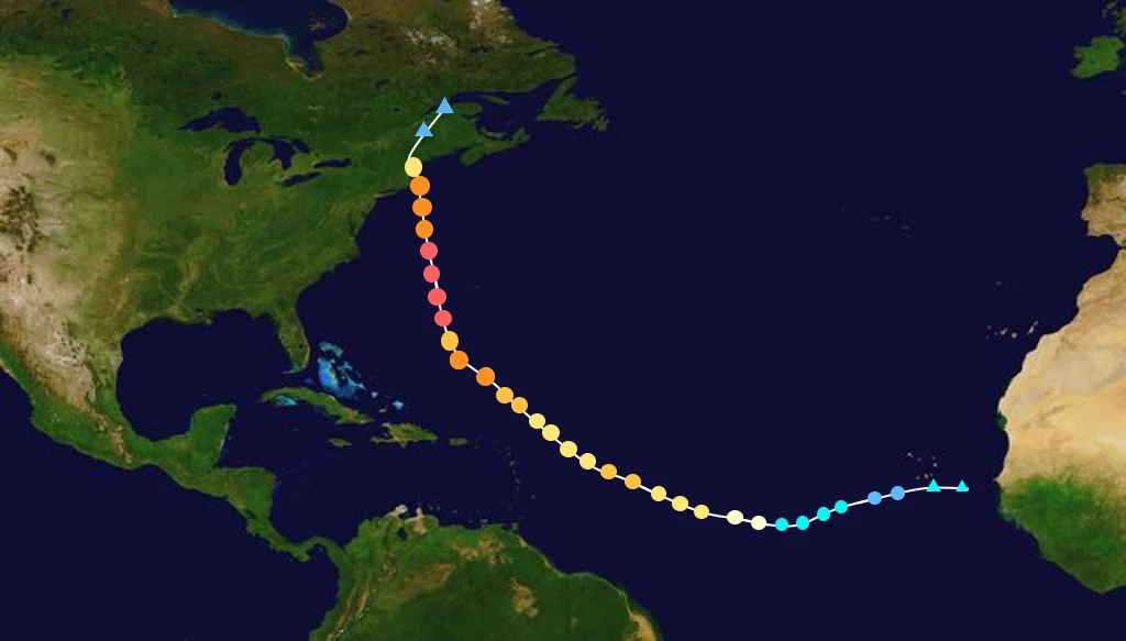
18 hours later, another round of rapid-intensification began occurring and on September 7, a Category 4 Major hurricane was achieved with winds exceeding 140+ MPH and minimal-central pressure of 947 hPa east of the Bahamas. The steering-currents carrying the hurricane pushed it more west-northwesterly bringing it closer to the East Coast of the United States. Additionally, Wanda excessively curbed its speed, slowing down to 4 MPH. Consequently, of this, dangerous rip-currents and very-unsettled beach waves rocked both the Bahamas and southwestern Florida coast. Beaches along these areas issued a high risk for rip currents on September 8. On the same day, however, an unexpected eyewall-replace-cycle caused Wanda to briefly weaken back into a low-end Category 3 Hurricane. But due to the system's slow-movement and the continued trend of very-warm ocean temperatures in the west Atlantic basin, re-intensification was expected to occur the next day. And on September 9, the hurricane underwent another bout of rapid-intensification and erupted from a low-end Category 3 with winds exceeding 115+ MPH to an extremely dangerous and very-powerful Category 5 major hurricane with winds exceeding 160+ MPH, and with a minimal-central pressure of 924 hPa. At this point, steering-currents were pushing this storm extreme Northwestward towards the Northern east coast of the United States (New England), Due to Wanda's unprecedented size, more intense rip-currents, and beach swells were sent out towards the East Coast at an alarming pace. Hurricane Wanda continued its slow-movement trend and went down to a snails-pace of only 2 MPH. Over the course of several hours, the major hurricane continued to intensify-rapidly. 160 MPH+ winds turned into 175 MPH+ winds in just 24 hours. The next day on September 10, multiple reports of rip-current and extremely-violent swell related-deaths were confirmed across the East Coast of the United States and even the Island of Bermuda. One man drowned in western Bermuda after he was caught in a rip current and dragged out to sea by ferocious waves, another swimmer trying to save the man also drowned in the process. Subsequent rip-current deaths were reported in Jacksonville, FL, Savannah, GA, Charleston, SC, Wrightsville Beach, NC, Nags Head, NC, Carova Beach, NC near the Virginia/North Carolina border, and Virginia Beach, VA.. 9 people in total were killed by Rip-currents from Hurricane Wanda. With the extreme threat of a major impact in the Northeastern mid-Atlantic and greater New England United States becoming evident by September 11, the governors of Maine, Rhode Island, New Hampshire, Connecticut, and Massachusetts all declared a state of emergency. On September 12 and 13, the states of Rhode Island, New Hampshire, and Maine issued mandatory evacuation orders for some of their coastal communities, predicting that emergency personnel would be unable to reach people there once the storm arrived. Hurricane Wanda prompted a very panicked and hassled evacuation scare for hundreds of thousands. in coastal Rhode Island alone, Gas stations in Cape Cod were packed to the brim almost immediately. Multiple fights broke out at stores across the state of coastal New Hampshire and Southwestern Maine. Over 500,000 people evacuated the coastlines of New England. Panic-buying caused supply stores/Gas Stations to have items flying off of their shelves at extreme rates. Major Traffic along Interstates 90, 95, 495, 90, 291 and 395 in Connecticut and Rhode Island caused multiple accidents and in some instances, traffic was stationary for hours.
As Hurricane Wanda very slowly, with an extremely slow movement-speed of only 3 MPH, inched closer and closer to the New England states as a Category 5 Major Hurricane with winds now exceeding 185 MPH+ and minimal-central pressure of 915 hPa, the colder waters of the New England coastlines caused a last-minute weakening-trend which brought the storm down to a Category 4 hurricane with winds exceeding 150+ MPH with a minimal-central pressure of 925 hPa on September 15. By the 15th, most people had evacuated, and places like Cape Cod, RI, Boston, MA, Portsmouth, MA, and Portland, ME were left as ghost towns. Approximately 58,000 people decided to ride out the storm, but with dire consequences. Hurricane Wanda maintained its Category 4 major hurricane status as it got even closer to the coast of Rhode Island on September 16. Hurricane path projections that came out on September 9, most forecasters chose to believe that the hurricane would immediately turn west and would make landfall on the west coast of Nova Scotia in Yarmouth. However, that quickly changed and path projections now have a cone of uncertainty ballooning inwards towards eastern New England making landfall in Cape Cod, and then lopsiding to the right towards Nova Scotia on September 11 when Mandatory Evacuations first started being underway.
Finally, on the evening of September 17 at around 4:02 UTC, Hurricane Wanda made direct landfall in Cape Cod, Massachusetts as a Category 4 major hurricane with winds exceeding 150+ MPH with a minimal-central pressure of 925 hPa.
WIP
| Meteorological history |
|---|