To view an animation of this storm, visit the link here: https://www.youtube.com/watch?v=a9sQn1_pXTU
| Category 3 major hurricane (SSHWS/NWS) | |
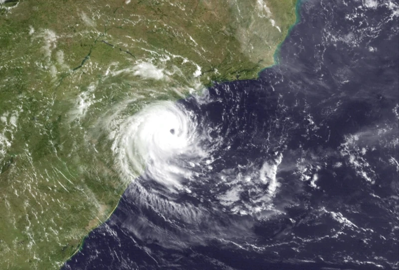 Yakecan at peak intensity on February 8 | |
| Formed | February 1, 2025 |
|---|---|
| Dissipated | February 10, 2025 |
| Highest winds | 1-minute sustained: 120 mph (195 km/h) |
| Lowest pressure | 964 mbar (hPa); 28.47 inHg (Record low in the South Atlantic) |
| Fatalities | 4 direct |
| Damage | $760 Million (2025 USD) |
| Areas affected | Rio de Janeiro, Paraná and Santa Catarina, Southern Brazil |
Hurricane Yakecan (Portuguese pronunciation: [jækə'kɑːn]) was the first ever recorded South Atlantic major hurricane in history, as well at the strongest recorded storm in the basin, overtaking Hurricane Catarina's record set in 2004. It caused severe damage after it made landfall in southern Brazil with Category 3-force equivalent sustained winds.
The storm developed from a cold-core trough on January 28th that produced flooding in parts of southern Brazil, leaving 2 dead and 5 others missing. About 3 days later, the Brazilian Navy Hydrographic Center noted a system about 150 miles south of Rio de Janeiro, designated "Subtropical Depression 01Q". Unusually favorable conditions led to the intensification of the depression, and on February 3rd, the BNHC declared the system tropical. On January 4th, the system acquired gale-force winds and was unofficially named Yakecan by the BNHC. The system continued to steadily intensify as it made a southwestward turn before becoming a hurricane on February 5th. Despite generally moderate wind shear, Yakecan continued to steadily intensify as it moved westward, attaining Category 2 status on February 7. On February 8, Yakecan reached its peak intensity with winds of 120 miles per hour - those of a Category 3 hurricane. Yakecan weakened slightly before making landfall as a major hurricane, before its condition rapidly deteriorated after landfall.
Yakecan caused extensive damage around the landfall area. Flooding was the major impact, as the population were not prepared for an event of such degree; Yakecan was only the second hurricane, and only major hurricane, to make landfall in Brazil. Brazilian officials, although generally unprepared, used resources and experience from Catarina to help take appropriate action while preparing for Yakecan's impacts. Yakecan destroyed over 3,000 homes, and damaging many others in the area, with estimates ranging from 10,000 to 75,000. Four deaths were confirmed after Yakecan's passing, with several hundred more injured. Damages amounted up to US$760 Million.
Meteorological history[]

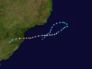
Map plotting the track and the intensity of the storm, according to the Saffir–Simpson scale
On January 28, a cold-core trough exited the coast of Uruguay, entering the southern Atlantic Ocean. The trough was nearly stationary as it slowly moved up the Brazilian coast, where it began to acquire subtropical characteristics. On January 30, favorable conditions led to the development of a disturbance, as the low began to undergo warm seclusion. Unusually warm water temperatures upwards of 27 °C favored further development, and on February 1, a subtropical depression formed.
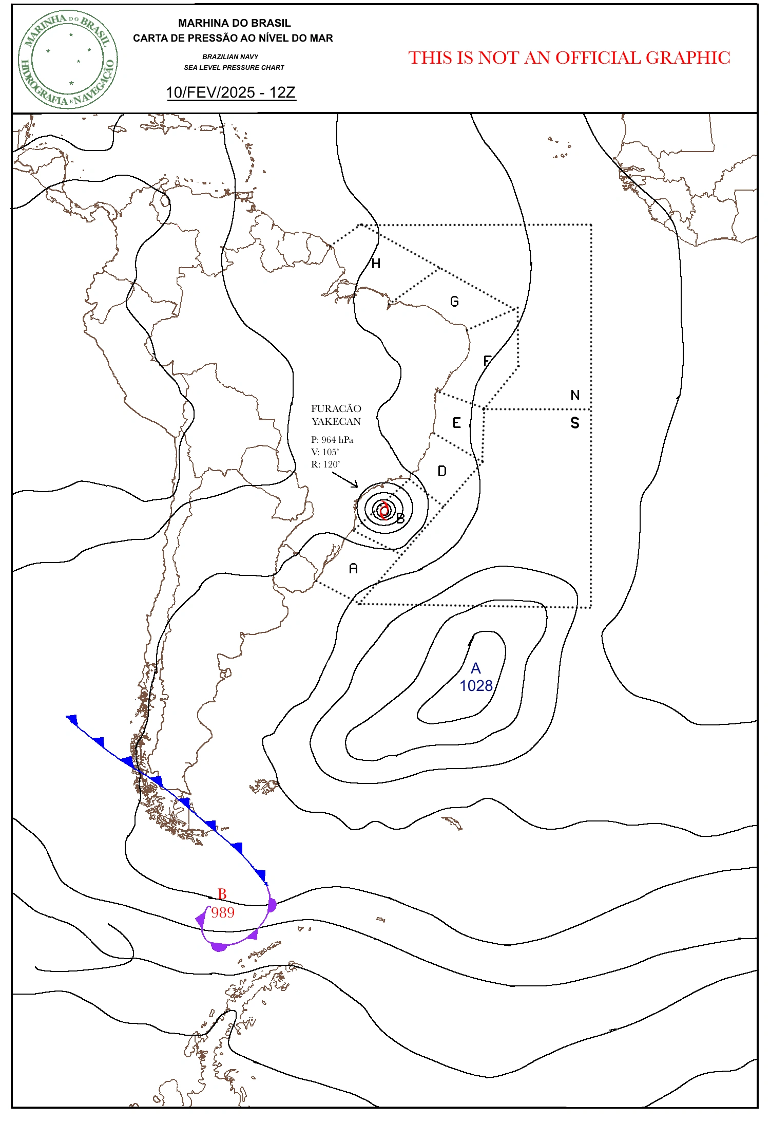
A sea level pressure chart made by the Brazilian navy, during Yakecan's peak intensity
The depression continued generally northwestward as its condition continued to increase. On February 2, the depression became tropical after convection began to increase around the centre of the system. The system made an eastward turn, before turning southward as a tropical storm. Yakecan became a hurricane on February 5, as it moved westward towards the coast of Brazil. The United States' National Hurricane Center declared the system a tropical, full-fledged hurricane on February 5; they described it as having a "defined eyewall" and "the usual characteristics of a hurricane". On February 7, the system attained winds of 110 mph, breaking Hurricane Catarina's record of 105, making Yakecan the strongest South Atlantic hurricane on record.
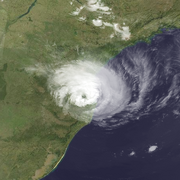
Yakecan became a major hurricane on February 8, stunning meteorologists around the world. The satellite presentation of Yakecan was one never seen before in the South Atlantic, with a well-developed eye and eyewall, as well as rainbands extending over 100 miles from the central dense overcast. Yakecan's presentation continued to improve up until landfall, before making landfall with winds of 120 mph, those of a major hurricane. After landfall, Yakecan rapidly dissipated, and by February 11, the remnants of Yakecan were untraceable.
Naming[]
The Brazilian Navy Hydrographic Centre has an unofficial list of name designations, going in alphabetical order. The name "Yakecan" final name on this list. Most North American forecasters used this name to refer to the system. However, the National Hurricane Center originally used "50L" to designate the system, despite being out of their area of coverage. In popular media, some outlets referred to the system as "Catarina 2" or "Catarina 2.0" during the initial development of the storm.
Retirement[]
Because of the powerful and destructive nature of the storm, the BNHC unofficially retired the name "Yakecan" and replaced it with Yana. Yakecan will never be used for another South Atlantic storm, and Yana will instead be used. In 2026, the World Meteorological Organization decided that the naming list designated by the BNHC will be official, and any names given to storms designated in this area will be officially recognized by the WMO.
Impact[]
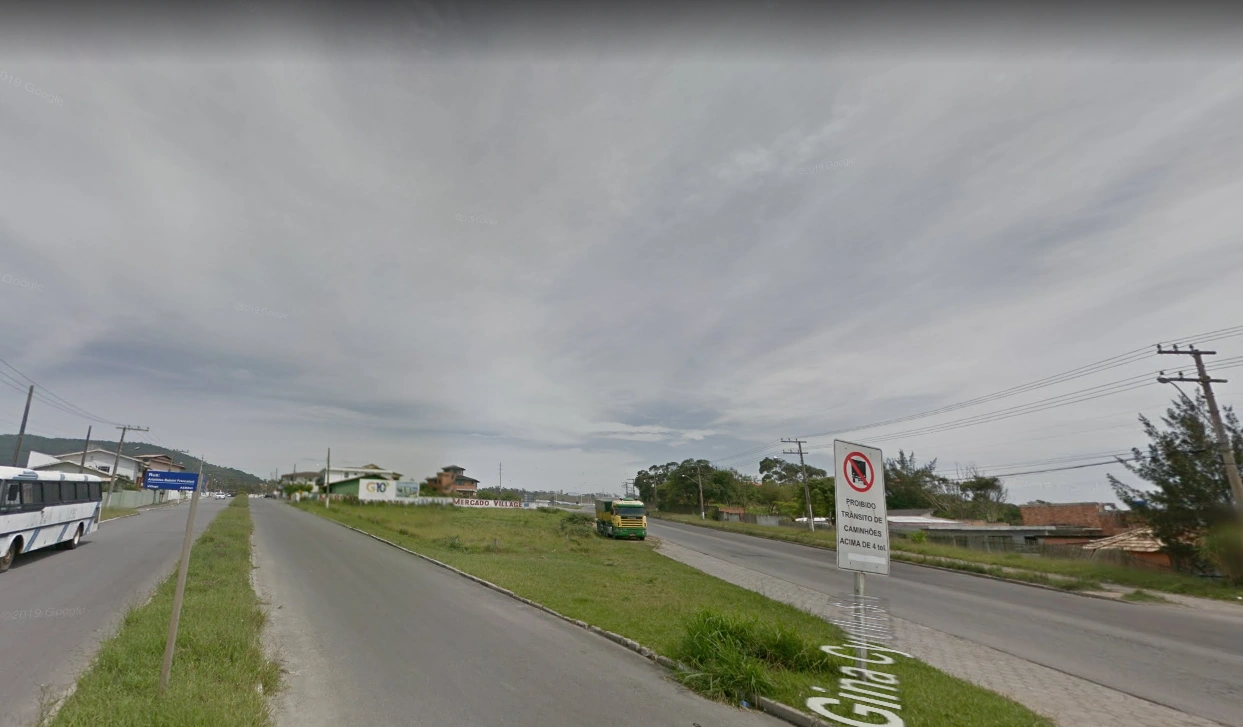
Imbituba, a town in southern Brazil around the landfall area of Yakecan (screenshot from Google Street View™)
Yakecan brought extreme flooding to the areas around it landfall, especially in the lesser-income areas of southern Brazil. The high uncertainty of the system worsened its impacts, as the Brazilian officials were not completely prepared for a disaster of this scale. Yakecan made landfall about 16 kilometers south of Florianópolis, the largest city in Santa Catarina. Storm surge of 9 feet, as well as torrential rainfall caused areas of the city to flood, caused the deaths of 4.
Florianópolis experienced gale-force winds from the generally small system, although areas to the south reported winds upwards of 90 mph, those of a Category 1 hurricane. The Imbituba Port halted all transportation as the Yakecan neared; it resumed on February 10. Several houses around the landfall area were flooded from storm surge, especially those near the coastline, leaving several hundred people homeless.

Yakecan over land, after landfall
After the storm, over 69,000 residences were damaged, and over 10,000 were completely destroyed, the most out of any recorded South Atlantic tropical cyclone. Severe flooding occurred inland as Yakecan continued after landfall, leaving 2 dead and hundreds more injured. The Uruguay River flooded, inundating areas around it in over a meter of water. The town of Barracão in Northern Rio Grande do Sul was forced to evacuate after the waters from the river neared the area.